Here is location of 1st Como Depot

1234

1234
Here is location of 1st Como Depot

|
I believe this old map shows the location of the first Como depot on the West side of the track.
Tell me if I am wrong. John. 
|
Re: Here is location of 1st Como Depot
|
|
This may help.
The location of the depot is in the space of where the Dispatcher's quarters were eventually built to the far right in this map which identifies Broadway street and it's intersection which shows in the next photo.   Following the mainline through, it appears then that the depot was removed for the construction of more tracks West side of the Mainline. Regardless, I still believe that A depot was built south side of the Engine House tank in this common sense level area. Perhaps the depot located West side of the track was relocated there.  I attach a page from the B,B&S book. Look at the size of the Oil House platform.!! Oil House, Item 6. Depot item 1. Only just a little smaller than the current depot platform. And yet to my knowledge, that Oil House was never located although logic would have it close to the Engine House. At least Mike Blazek could not locate the Oil House or its platform.  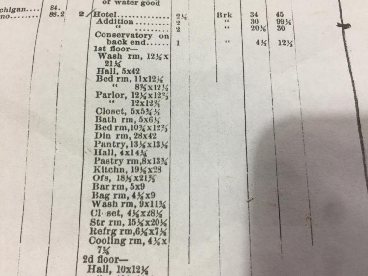 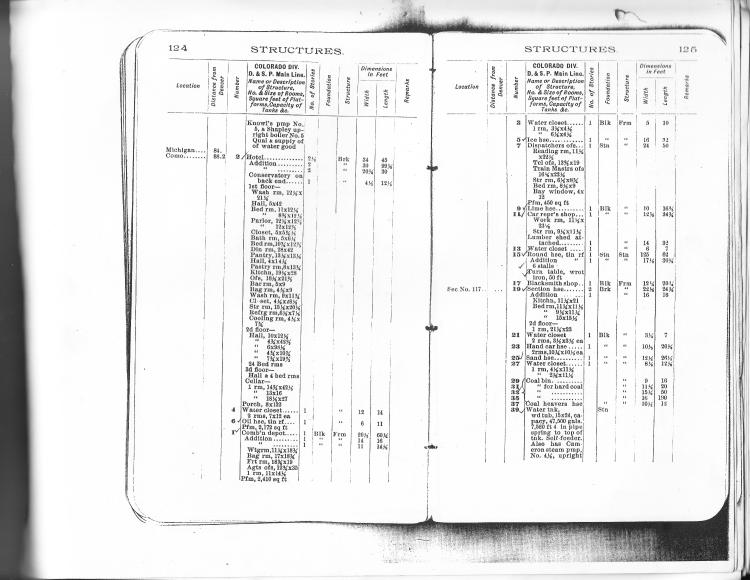 John |
Re: Here is location of 1st Como Depot
|
|
In reply to this post by John Droste
John,
Recently I've been digging through 1879-1881 newspapers on an unrelated topic but in the process have been following the progress of the line as it worked west during the Leadville boom. Starting in June 1879, Como became the major shipping point to Leadville, the site primarily of several large warehouses and then a spur to a local coal bank that would later become the start of the route to Breckenridge. Presumably Como in the first two years was primarily a fairly simple yard focused on teaming the massive freight loads coming in on the South Park (reported as 25+ cars daily to this point). It remained so as the track pushed to the west edge of the South Park in 1879. Even after the Leadville joint track was in operation the next year the forwarding and teaming companies had a strong presence at Como. Como did not become a large divisional railroad center before Spring 1881 when we see the construction of the roundhouse and shops under way. I've not seen any map nor photos of the early, pre-roundhouse, yards. What is the source for the map showing the first depot?
Dave Eggleston
Seattle, WA |
Re: Here is location of 1st Como Depot
|
|
Dave,
From memory, I found the photo in the Como Depot & Roundhouse Facebook page. Just looking now I found some photos explaining that Como was once a town by another name. I had predicted this recently in my other posts.  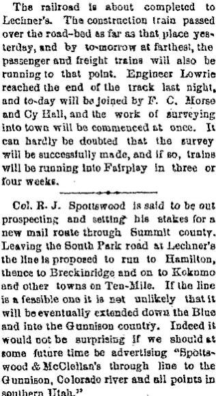 Whilst a member of the DSP&P HS I was informed of these things; North end of the depot was the Ice House. Also the Post Office. The reasoning given that the Ice House was then presumed to be behind the current depot and Pacific Hotel. This of coarse is a ludicrous suggestion. And the Post Office??? Also, early distances to Como were longer and then the distance was made shorter. It was presumed that the track had been realigned somewhere along the way making the distance shorter. No other stops had their distances altered however. Common sense would place the depot below the township on the ideal level grounds which the railroad had gained from the town. Only a water tank was placed here though, a track each side and what seems to have been a platform before it was covered in rubble. The Waste of the Engine House and Tenement buildings construction. 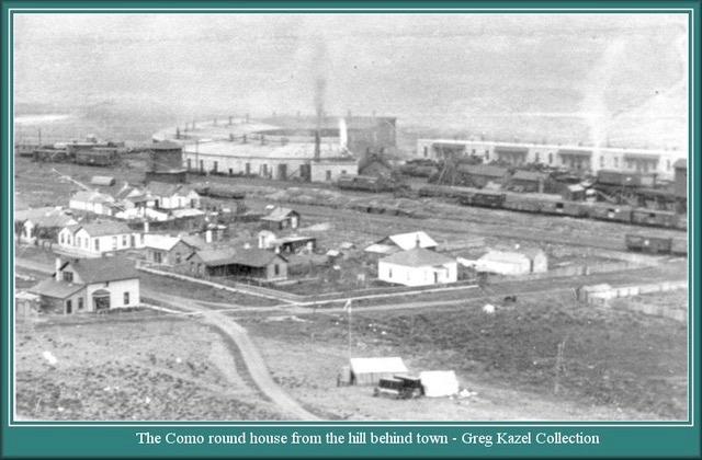 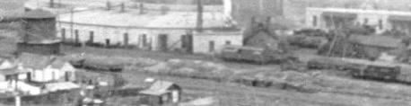 My M. Blazek, Como workbook is packed away but here is a photo also from the CD & RH Facebook page which shows recent works and prior track positioning. In that it shows more clearly that the current depot is straight across from where the building across the way was. I doubt it was a warehouse. If I am correct all round in that case there were then three depot's in Como. maybe it was just a railroad car at first. That happened.  Notice how where the location of the Gilman Hotel which was a whole basement deep inside the curve of R o W is in exact alignment with Rowe street which was the main road south at that time. 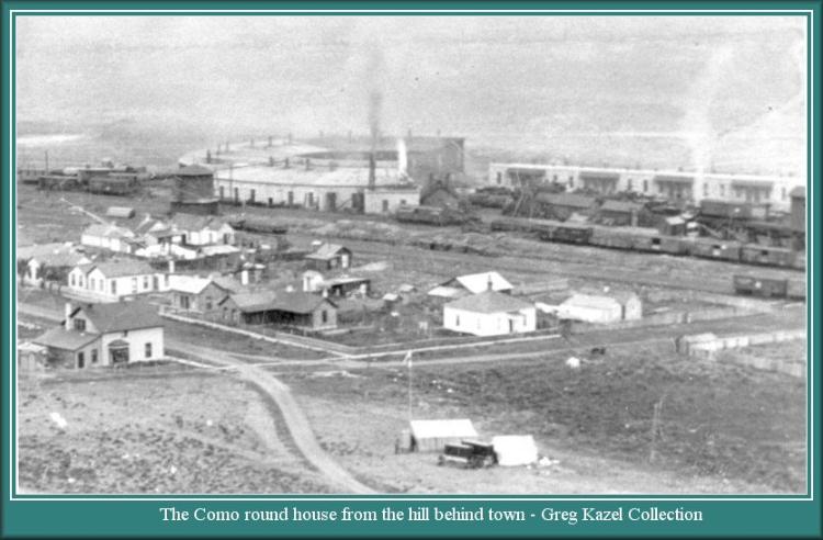 John |
Re: Here is location of 1st Como Depot
|
|
So you don't have the source for that map.
There were several articles on Lechner's (aka Lechner's coal bank) in the Fairplay Flume and Rocky Mountain News from May-June 1879 as the line approached the location of the future Como. These can be found online on the Colorado Historic Newspaper site using its search engine. As far as I can tell, Como at the start was about 75 tents, a few frame structures and at least three teaming companies with large warehouses. What the original depot was isn't reported but there was something being used as a depot, mentioned in passing in the 7/17/1879 Fairplay Flume article on Como. It might've been a tent, a boxcar, a frame structure or someone's bedroom but the report doesn't tell us. All we know is there was an agent named McGill and he often was found in the office across from the depot, whatever that means. Before the railroad the location was empty; people weren't sure if Como would return to that once the track moved west. But it did prove an excellent starting location for the teams heading over Mosquito Pass to Leadville and so Como got a bit more dug in. The what and where of the original yards is a mystery but were geared to unloading 20+ cars a day into wagons and warehouses and dealing with the many many passengers going in and out. The tracks very likely changed dramatically when the roundhouse was built two years later and Como changed focus. Como is not the only place where the listed distance to Denver changes as the years pass. A review of Employee timetables, the B&B books and other documents reveal changes and even handwritten corrections to distances on some documents. An ask: It would be really helpful, as an aid to others who might be interested in looking into your comments, and out of respect for the archive, website or collection holding the image you are using, to cite images and documents you post. This is an important aspect in sharing and growing knowledge--it benefits you.
Dave Eggleston
Seattle, WA |
Re: Here is location of 1st Como Depot
|
|
This link will take you to the page Dave.
Scroll through the photos and you will find the map in question. And others. John https://www.facebook.com/como.depot |
Re: Here is location of 1st Como Depot
|
|
Here are the direct links to the maps:
"Original plat map": https://www.facebook.com/como.depot/photos/pb.100067516044131.-2207520000./2695103490708278/?type=3 Marked-up ICC map: https://www.facebook.com/como.depot/photos/pb.100067516044131.-2207520000./2339997629552201/?type=3
Dave Eggleston
Seattle, WA |
Re: Here is location of 1st Como Depot
|
|
This post was updated on .
In reply to this post by John Droste
Referring to the "original Plat" map (not the one with handwritten notes)
Given the date of the map it is possible that was a proposed site for the depot but not built. One would need to be able to read the entire title to determine the purpose of the map. As to the copy with handwritten notes it may or may not be correct. At some point there was documentation that would indicate date and where depot was built. Jimmy |
Re: Here is location of 1st Como Depot
|
|
Hi Jim,
The area in question does say Depot 'something?' I can't make out the second word. It is the area where the Dispatcher's residence was eventually built however. I guess that we can not confirm for sure if that was the first depot location be it a boxcar or whatever, only a planned location or something other but the word "Depot" is written there. I do ponder over why only this portion of the title came to be revealed. And I wonder why the second plan stops exactly where the depot would start. I can only say that my research is in finding matters which appear to link like two pieces of a puzzle and then finding the other pieces that fit into the picture as the puzzle forms. That as opposed to dismissing linking matters as coincidences on the premise of, 'If it is not written,It did not happen!' Clearly things did happen that we do not have in writing. But to misquote Mac Poor as I don't have his book at hand, "There is so much to research and I only had a limited time. Dont take it as gospel that everything I have written is correct." It was Mac that described the Como Depot. What he thought took place. I have had much mote time to focus on this area. With what he was trying to say in my misquote I think he would be appreciative of someone reviewing his observations and seeking to correct him. The articles about Lechner as a town and the street and cut block maps are evidence that there was a town. It is described as such even. I find that the pointed bend in front of the Gilman to be significant. Especially as the basement is below track level.  And I will point out further that the old highway coming from the direction of the Wye headed straight for the Gilman. Noting that the development of the Right of Way would have forced a rerouting. As can be seen. And more that once. 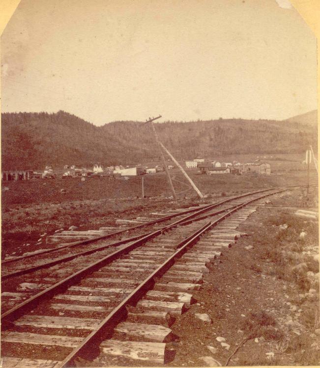 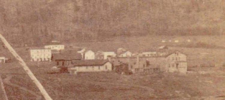 An article in the B&L pointed out that there had been a well under where the hotel was built. Evidence of activity prior to Como. I suspect that the basement of the Gilman at a minimum, was a division point for road traffic long before Como came into being. Stables and hotel. John |
Re: Here is location of 1st Como Depot
|
|
This post was updated on .
What I read is "DEPOT GROUNDS" in the open space.
I fully agree with Jimmy. We're seeing a portion of a bigger map and while the handwritten date puts it squarely on the mark for when Como came into being what is presented is not fully clear. I see the map as a data point, and not necessarily gospel. The location shown for a depot could just be a place holder. I see this as a very common speculative map, setting a stake in the ground, reflecting what was hoped to be. So: What are we not seeing on the map and whose archive holds it? Bottom line: I'm seriously cautious saying the map says much, if anything, about Lechner's. What Poor said is true, we do have limited time and lack access to everything out there. But that can't be used to defend or excuse research. It is very difficult to say something is absolutely true or someone is full of malarky unless you can solidly back it with data. Otherwise it's important to say that what you propose, based on "x, y and z," and then clearly make the case--while also admitting, unless the case is solidly backed, that it's a theory. My view is that Poor offered data and encouraged others to dig deeper.
Dave Eggleston
Seattle, WA |
Re: Here is location of 1st Como Depot
|
|
"What are we not seeing on the map and whose archive holds it?"
Yes, indeed. A good question. A quick reflection before I add more letters to the alphabet, beyond x, y and z. It appears that Lechner was a place, a ranch, however large that may have been. And it appears as if that the road and allotments were drawn before the railroad arrived. And that sometime later, further allotments were incorporated on the east side of the track. Much larger allotments. And those allotments did not allow for the eventual redirection of the old Plat Road.   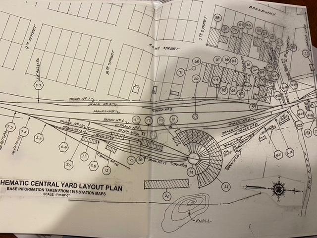 Poor did offer to dig deeper. He encouraged it. I am here because I came along without preconceived knowledge of Como. I could and can see the things that did not make sense. Each a "letter". By now, hundreds of letters that connect. All of what was perceived about Como were presumptions, written into word. This is the difference. A bank is robbed. a person writes a statement claiming they can identify the robber. Meanwhile, photographs are produced which identify the real robber. Yes, the evidence above may be speculation. I will continue showing photographs and asking questions. Asking you all to make sense of what does not make sense to me. Let's see if we can make some progress that way. John |
Re: Here is location of 1st Como Depot
|
|
I am attaching a plan that the owner of the depot supplied to me in order to do my research.
It seems that the more I discovered the less he wanted to know. Anyway, my gratitude to him. 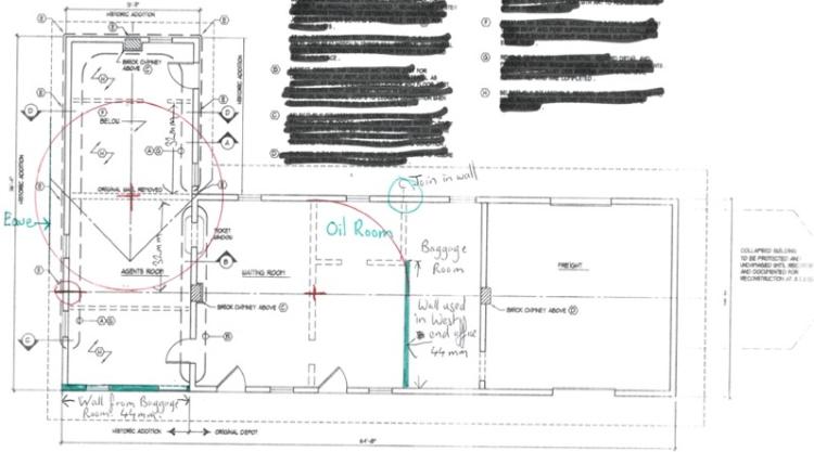 The plan poses a lot of questions so I will just cover sections at a time. If the supposed first stage of the depot (office) was added before the second stage (rear extension), why are the eaves of the first extension not the same size not the same size on the North end as the remainder as of the depot? Second extension stage excluded. I have pointed out the eave in green. Why would the rear of the second extension appear so much like the building next door to the D&RG station building were it was last positioned in Denver? Building on far right. I mean, how many buildings would you have to look at before you would find that likeness? 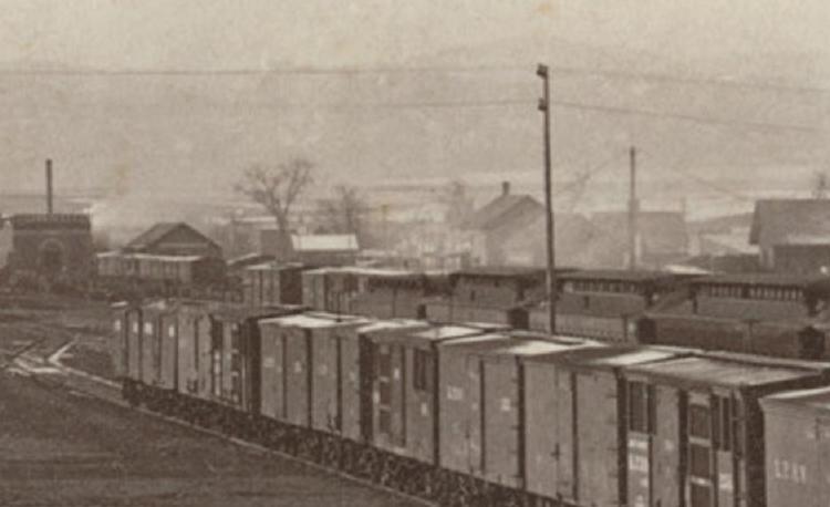  "Photo above and below used by permission Copyright Ken Smith Photography All Rights Reserved.” www.steamandmorephotography.com I would urge anyone with an interest in DSP&P history to buy the photo CD of Ken Smith. There must be almost a hundred photos of the depot alone. Invaluable as the depot is no longer the same.  Why would they make a brace on the corner of the North wall of the rear of the second extension and not the south side? I can answer that one. Because they wanted to dress up the North wall a bit when it was moved away from the hotel. Why the dogleg in the roof ridge? I can answer that one too. Why the infill above the door which is the same hight of the top of the window in the corner of the second extension that has a window the same size as the depot windows? I know the answer to these questions because I understood the questions. The answer is often simply in understanding what the question is. John |
Re: Here is location of 1st Como Depot
|
|
In reply to this post by John Droste
You've added an uncited image of an article. It was published in the Fairplay Flume on 6/26/1879.
Citing your sources is important: Out of respect to the artifact's holder, out of respect to other researchers looking into your assertion and out of respect to your theories.
Dave Eggleston
Seattle, WA |
Re: Here is location of 1st Como Depot
|
|
In reply to this post by John Droste
Are you comparing these two? 
Dave Eggleston
Seattle, WA |
Re: Here is location of 1st Como Depot
|
|
In reply to this post by John Droste
I'm curious.
Regarding the vintage view of the "D&RG depot" in Denver, what documentation would one consult to verify that identity? Jimmy |
Re: Here is location of 1st Como Depot
|
|
This post was updated on .
In reply to this post by John Droste
John,
Here’s an even more compelling question: Why would the South Park cobble together a bunch of structures from elsewhere when they had a dispatchers office in Como that was based on depots such as Jefferson and others. Seems they would just use the dispatchers office as a depot and a “cobbled” structure as a freight building. David Fromm |
Re: Here is location of 1st Como Depot
|
|
In reply to this post by Dave Eggleston
Dave & Jimmy,
Dave. Yes, the two buildings that you have drawn a line between is what I am referring to. As mentioned previously, http://c-sng-discussion-forum.254.s1.nabble.com/History-the-ego-identity-tp18831p18835.html the building behind the power pole was the D&RG station its second location, to my knowledge. And I am saying that it was moved to its third location to the far side of the building pointed at with the arrow. The last location was used for such a short time that it did not even get a listing in the City directory. It was explained in I believe Mac Poor's book in the section on the RG or Kenton Forrest's book, Denvers Railroads and will go for the latter that conditions were so bad for the D&RG that they moved into the Union Station "while the paint was still wet." The first location for the D&RG station was the other side of Cherry creek near 11th & 12th streets, if that makes sense. I believe from observations that the three locations had the very same building. That would mean that the station would have to be slid across the rebuilt Cherry Creek bridge. I am seeking photos of that bridge currently to know if that was possible. During these moves, I believe the D&RG shared depots with both the DSP&P and the CC. My books are currently packed away so it is difficult to verify quoting direct passages to a page. As to referencing where I gain much of my information, it is a very worthy question requiring explanation. I will do that but it will be a long explanation as there are various factors involved. In the meantime I will post a page from the Denver City directory without link (DLP) that gives the location of the D&RG Freight depot where it can be seen behind the D&RG Station in the photo in the location of the photo discussed. The year of the photo being taken is 1874 incidentally. Today, the Union Station would be in the background. The link below will be of a year before the Cherry creek flood, which I am not sure exactly what year that was off hand. But obviously before 1874 as was the history of the photo described to me.  Hello now, I have found my links to the yearly City Directory pages on Station locations. Some of the links may be wrong pages, Sorry. But at the very bottom I have kept the notes from the person that shared with me the information which I shall not name. Nor will I give the name to anyone that has shared information to me in confidence that the source not be revealed. Links below, John. 1884 map of denver Reference URL http://cdm16079.contentdm.oclc.org/cdm/ref/collection/p16079coll39/id/8 1880 annual directory page http://digital.denverlibrary.org/cdm/ref/collection/p16079coll28/id/8670 http://digital.denverlibrary.org/cdm/ref/collection/p16079coll28/id/8670 1881 directory page 25 http://digital.denverlibrary.org/cdm/ref/collection/p16079coll28/id/9690 http://digital.denverlibrary.org/cdm/ref/collection/p16079coll28/id/9102 1879 page 25 passenger and freight depot together http://digital.denverlibrary.org/cdm/ref/collection/p16079coll28/id/8369 1878 passenger and freight together http://digital.denverlibrary.org/cdm/ref/collection/p16079coll28/id/8089 1877 ticket office, freight and passenger depot south west corner http://digital.denverlibrary.org/cdm/ref/collection/p16079coll28/id/7821 1876 freight and passenger depot south west corner http://digital.denverlibrary.org/cdm/ref/collection/p16079coll28/id/7540 1875 freight and passenger depot south west corner http://digital.denverlibrary.org/cdm/ref/collection/p16079coll28/id/7540 1874 freight and passenger south west corner http://digital.denverlibrary.org/cdm/ref/collection/p16079coll28/id/6989 1873 freight and passenger SOUTH EAST CORNER http://digital.denverlibrary.org/cdm/ref/collection/p16079coll28/id/6701 1872 file.php Map 1873 photo 1882 directory Page 31 1882 railroad directory page http://digital.denverlibrary.org/cdm/ref/collection/p16079coll28/id/9721 Map, 1878-79 showing layout Of Kansas/Denver Pacific passenger and freight, Denver & Rio Grande and Colorado Central depots. In 1879 the Denver, South Park & Pacific was also interchanging with the Colorado Central thus the second bridge over cherry creek (Wewatta St), the D&RG being the first being rebuilt after the flood of 1878 (Wynkoop St). Interesting subject. I think the D&RGRy had 4 different Denver stations before the completion of Denver Union Depot in 1881. I need to review some research material which I have in storage, perhaps I can post next week in detail. A big game changer was the washout and destruction of the bridge over Cherry Creek in 1878. Bo a Google search on D&RG annual reports 1871-1883 there are some building reports and valuation. The second D&RG station is left of the telegraph pole, beyond the Kansas Pacific passenger train, 1873. |
Re: Here is location of 1st Como Depot
|
|
John,
You've been making this argument for several years in several forums. I have to admit that I'm still hung up on the same question David Fromm asks: Why would they move this one building section to Como? To push this further: What is so unique about this piece of building that they'd chose a move over either new construction or moving a local Como building? We have solidly verified that the railroad did move some structures in the 1880s (examples include: Hancock station (1887), Crisman water tank to St Elmo (ca 1886-1888), Woodstock section house to Alpine Tunnel (1890), a turntable to St Elmo (1885) and large items such as the Platte Canyon iron bridges in 1878). Records and photos exist for these moves--and all had a specific purpose as a structure that was critical to the move decision. What you propose, while physically possible, lacks that type of justification I see for the other structure moves. That building wing seen in a fuzzy picture looks unpresupposing and common for that time. The logistics of this move would be significant, the costs not insignificant. The questions I ask are: Why this particular piece of a particular building? What was the cost of deconstructing and moving this structure 88 miles up Platte Canyon and Kenosha versus building it new? From mid-1878 up to January 1881 the South Park was making money hand over fist on the Leadville traffic. And yet at the same time every expense was being scrutinized. They were deliberate in what they did. They also didn't have much bandwidth to move things given the vast traffic--Leadville and construction--they were dealing with. When the UP took over the oversight became worse. Yes, the UP spent money on bad ideas (where there was a whiff of profit) like a drunken <fill in the blank> but they also were stingy on spending on small details. Overall, all the detail on the various constructional bits is part of the story. You've gone deep on those. But to me it is just as important to understand the motives and justifications (financial and business ops). Why would they do this move instead of the other options?
Dave Eggleston
Seattle, WA |
Re: Here is location of 1st Como Depot
|
|
… And what is the argument for using what appears to be (at the time) a standard depot in all respects for merely a dispatcher’s office? Why would you have a dispatcher’s office that looks better than the Como Depot? Seems a complete waste of a structure.
David Fromm Seattle, Washington |
Re: Here is location of 1st Como Depot
|
|
In reply to this post by John Droste
I clearly understand the location of the D&RG passenger, freight station was at one time located at 19th and Wynkoop.
However, my question was directed at the photo you posted of a structure and indicated it was D&RG depot. The location of that particular photo, to me, does not appear to be 19th and Wynkoop. You also posted a "train order board" photo you identify as D&RG depot at 19th and Wynkoop. I believe that is not the case. The D&RG was sole owner of trackage leading to 19th street from the west. East of 19th street trackage operation was joint. In viewing the full image of "train order board" that structure appears to be east of 20th street, northeast corner. I do not see a train order board. In the lower right corner of the view, narrow gauge flat cars are visible just west of 19th street. The narrow gauge tracks continue to 20th street at which point trackage becomes 3 rail for certain tracks. Also, in the lower right corner it can be noted that the KP standard gauge tracks do not cross 19th street. As a result I do not believe the D&RG depot is visible in either photo. |
«
Return to C&Sng Discussion Forum
|
1 view|%1 views
| Free forum by Nabble | Edit this page |