Here is location of 1st Como Depot
1234


1234
Re: Here is location of 1st Como Depot.
|
This post was updated on .
We seem to have drifted back to Denver again.
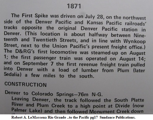
 John appears to have cross-pollinated two different buildings as to supporting his migrating Como Depot addition theory. Robert LeMassena has the only reference to this - (as far as I have read; I do not have Crossen's Denver Railroads) found on pg 248 of his Sundance Publications Volume Colorado's Mountain Railroads, 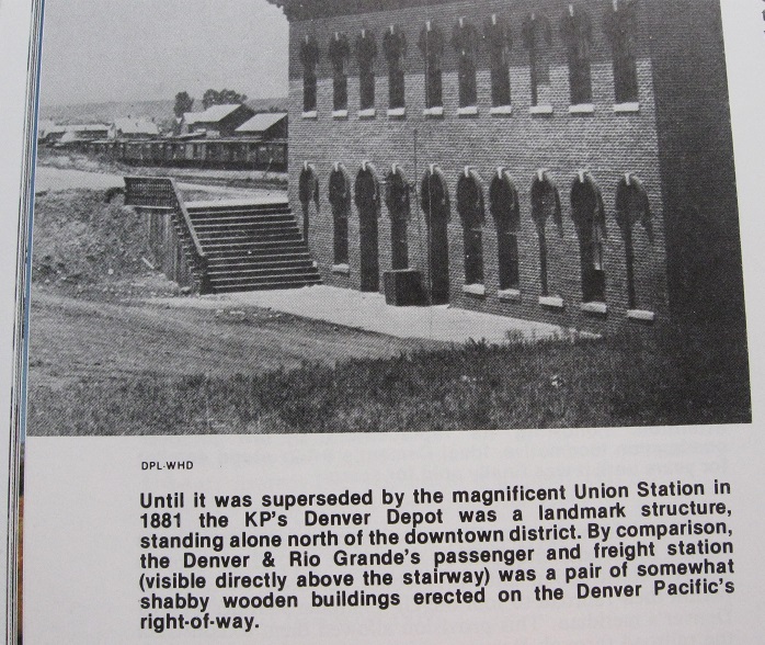 and in his Sundance Publications Rio Grande...to the Pacific pg 19. 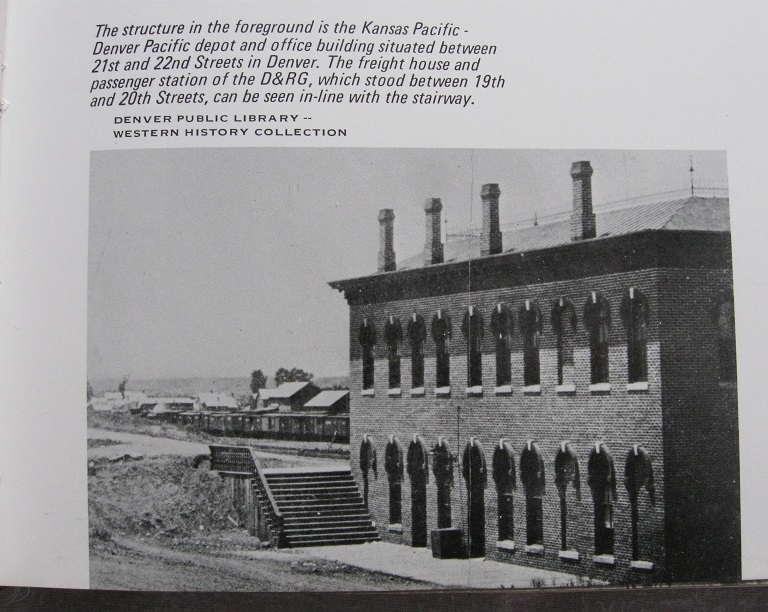 The image is in the DPL X-25217 Denver Public Library CG4314 .D41878 .W5 1878 Map of Denver, the capital of Colorado : compiled from the official records. 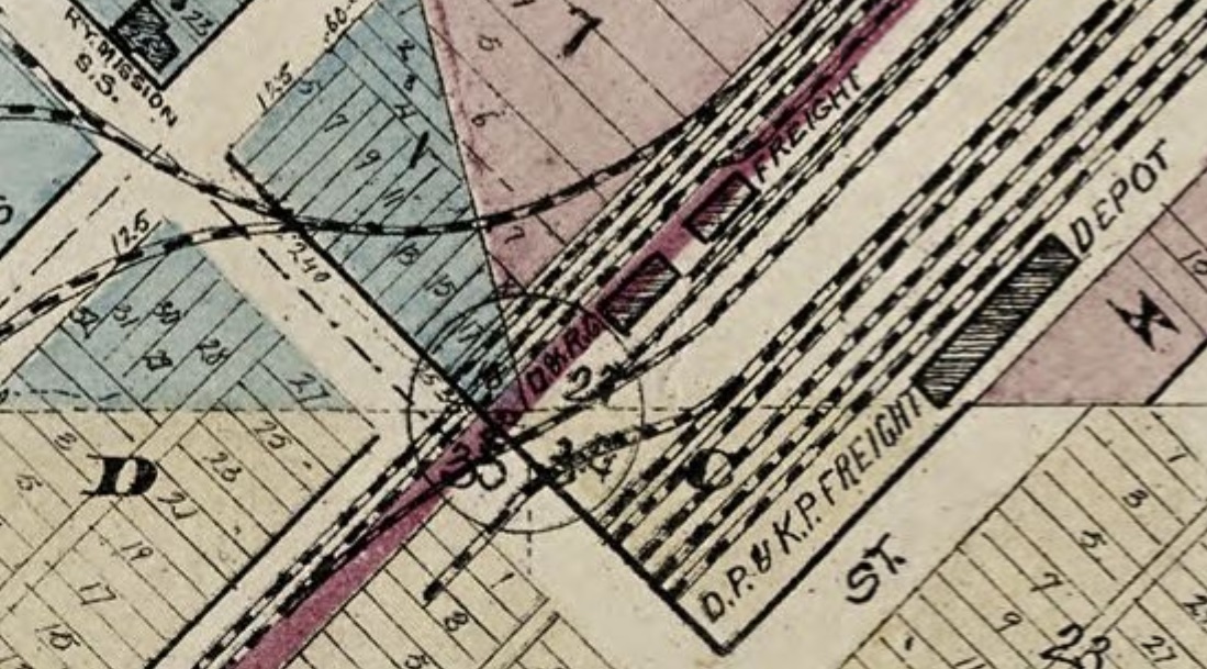 The above map does not differentiate gauge of track. EDIT: not specifically called out, but on further examination of the wider map area, there are actual stub-end of tracks by delination: My Bad; see newer post below. The other Building that John also attributes to being the Como addition is in a different location from those shown in the Kansas Pacific Station image; however it is not on the Northwest corner of 19th St/Wynkoop but behind Delaneys, and now served by a Standard Gauge Denver Pacific/Kansas Pacific(later UP) siding; at this time period(1881;completion of Denver Union) the D&RG was only 3ft gauge. For reference the Grand Hotel visible is on 18th St. and 20th St. is truncated(severed) by the KP/DP yards. There are two versions available DPL Z-11785 and DPL WHJ-10461, the latter has a differing contrast. 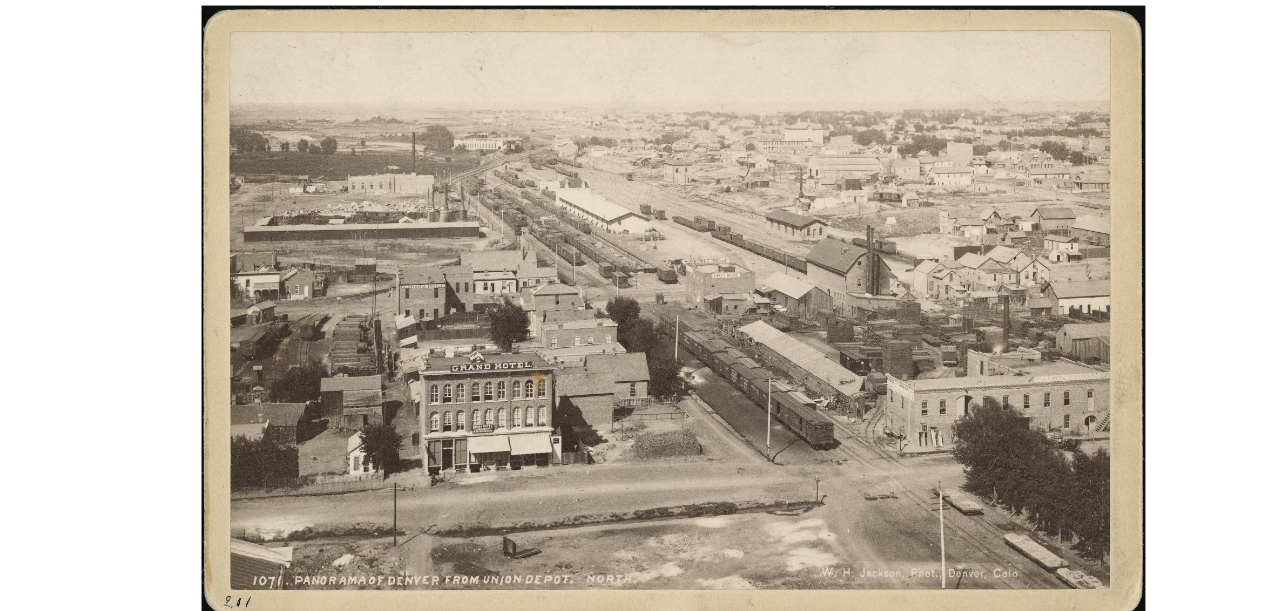 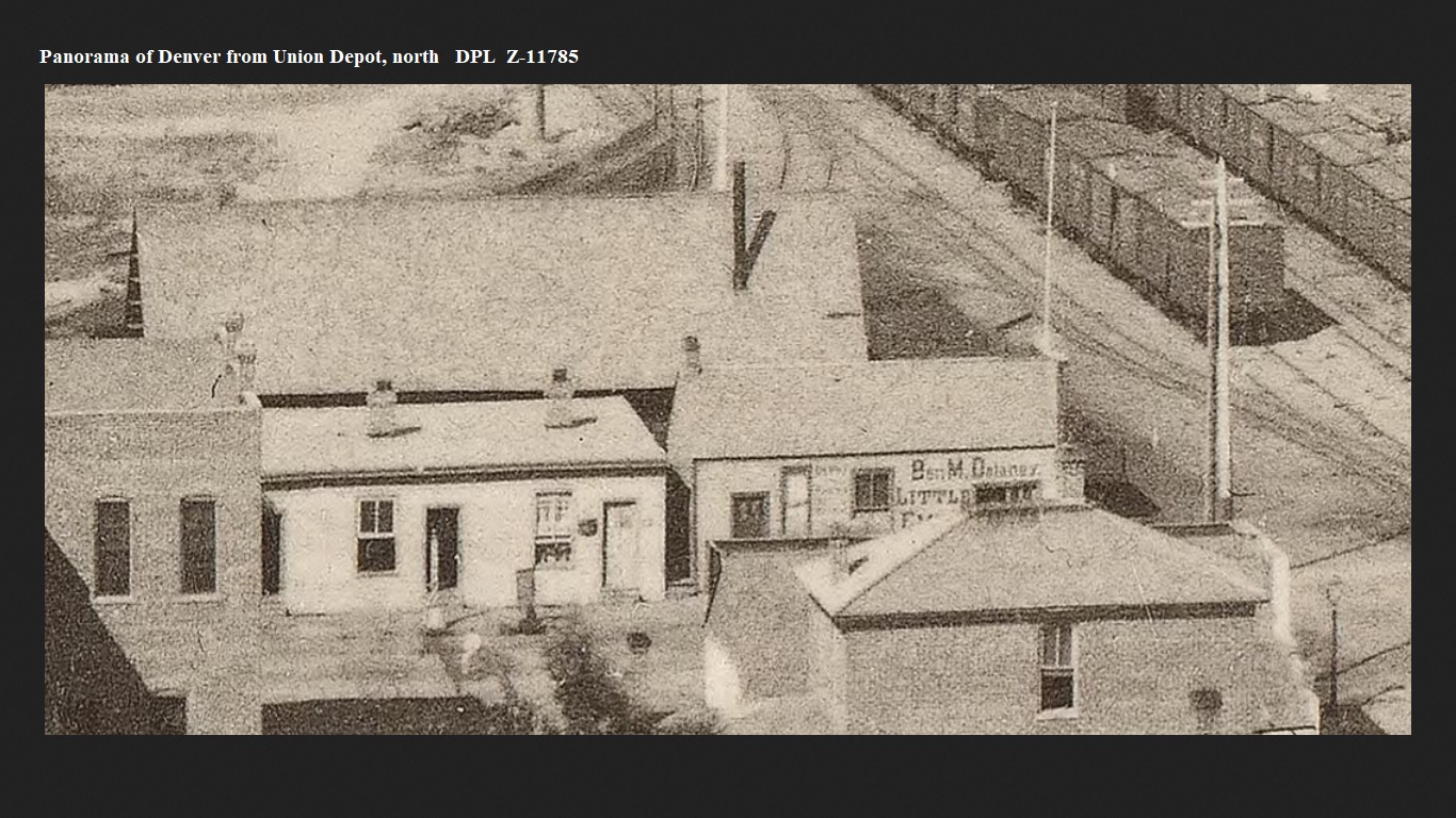 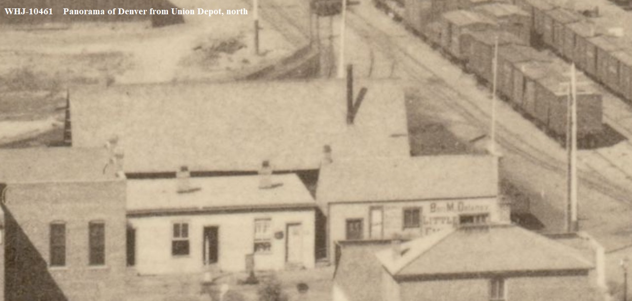 Note the above images; they show an Alley left of the Grand Hotel, that Sanborne Fire Maps(1887 earliest available for Denver) show to be 16ft wide with the Wynkoop and 19th Streets both at 80ft wide. There are loaded Coalcars on the stub-ended s.g. siding. I have for quite some time, hoped someone-else would point out the disparity in the size of these two buildings and the Como Depot addition as is. Mac Poor in D.S.P.&P. (pg 422) states the dimensions as 20ftx60ft Depot: 1st Addition 14ftx16ft. 2nd Addition 11ftx14ft. Maynard Rormans Plan in Colorado Railroad Structures has close supporting numbers. The Alpine Tunnel Telegraph Office(for comparison) is 14ftx20ft and for all intent and purpose, does not impose like the two Wynkoop St examples of Gabled structures. DPL X-6498 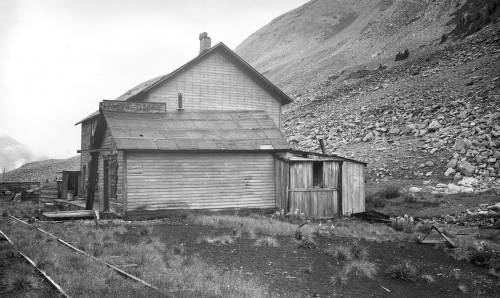 Jimmy, The s.g. track did continue down Wynkoop St to just beyond 16th Street, the site of the DP/KP Depot(circa 1878). Denver Public Library CG4314 .D41878 .W5 1878 Map of Denver, the capital of Colorado : compiled from the official records. 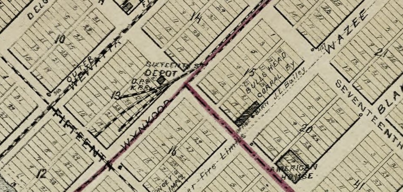 DPL WHJ-10438 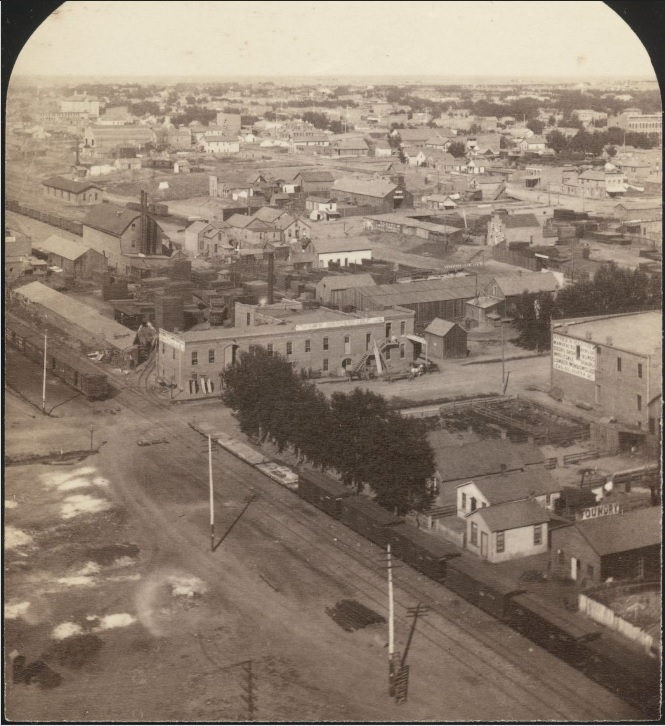 DPL WHJ-10457 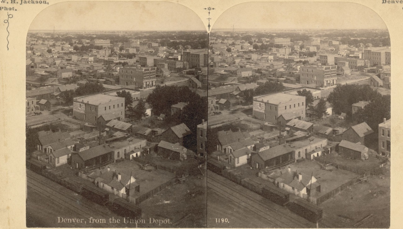 DPL WHJ-10477 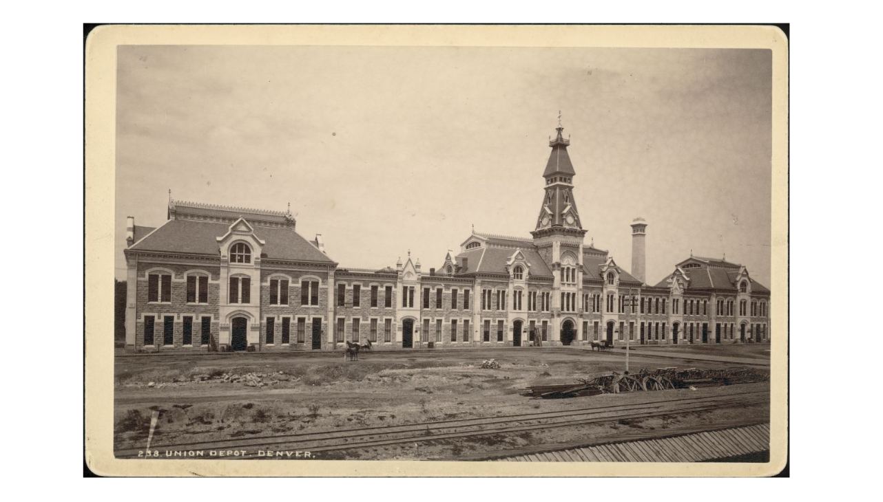 One s.g. and one n.g. track visible here post-completion of the DU; prior to the addition of a 3-rd rail on the D&RG track. Later 1883 photo of DU show changes here. DPL WHJ-10437 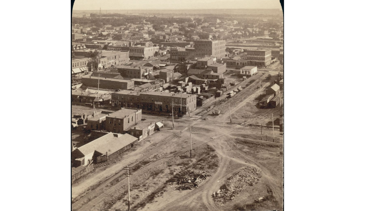 Jeff Ramsey posted this companion image elsewhere a long time ago: Shows the ex-DP/KP Depot in use as a Coal Dealer and the new-ish Stone D&RG Freight Depot* in the distance. 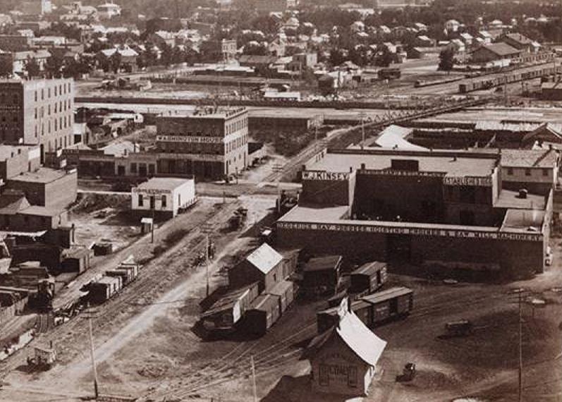 The innocent capture of the Flagman at 16th St is way cool!  *That structure has been mis-identified in some books as to being in Alamosa.
UpSideDownC
in New Zealand |
Re: Here is location of 1st Como Depot.
|
Wow, wow , wow!
So much baggage to sort through today, but first I commend you Chris on some amazing work. I will try and respond to all as best I can hoping I don't miss anything. David used the words "Cobbled together". They are the exact two words that the President of the DSP&P HS used in his President's report in the B&L acknowledging what I had been saying. His words acknowledging that the Depot was assembled from different buildings. Referencing in particular the "extensions". This was I believe the first report following the Commencement of works by Older Than Dirt. Here again is the location of the D&RG station positioned in the middle of the Northern cross hair. 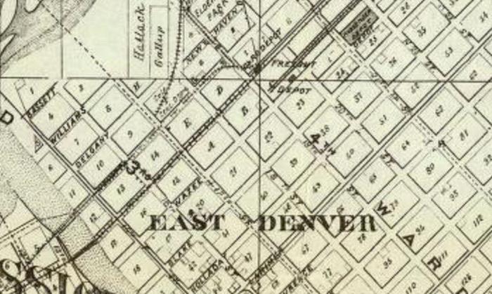 Which also happens to be the location of the 'sleeping quarters wall' that I am obsessed with. 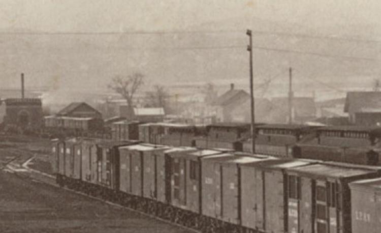 Thank you again Chris, This 1874 photo shows the depot behind the telegraph pole. Later to be positioned in the aforementioned map. The row of cars in front are KP it was explained. Here is another map showing that the building I was obsessed with and the DRG Station is no longer there. Yet the track has not of yet begun to be altered for the coming railroad yards. 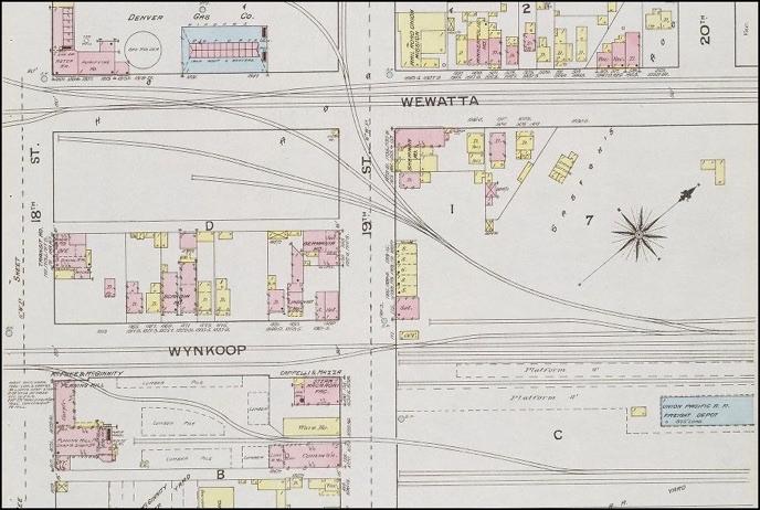 For reference, a broader view of 19th street across the KP yard. 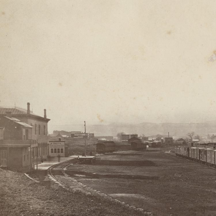 Take notice of facades of the buildings in 19th street facing this way and identify same buildings looking back from the tower of the Union Station. http://cdm16079.contentdm.oclc.org/cdm/ref/collection/p15330coll22/id/88627 I am just going to stray a bit on this last photo. I believe it is the Boulder Valley cutting across above the roof of the RG Station. And I believe it be a row of DSP&P cars along the BV line, parked next to a stone works. I would not doubt that this masonry works was cutting stone for the Union Station, however the Union Station was now complete so they were not likely to be delivering stone any more from their branch quarries but removing refuse. To be used elsewhere. 1881, determined by the grounds of the Union. There is something else. To the right of the stone works in the middle of the narrow gauge train there seemed to be a flat car with an A frame in the middle. I thought this an excellent way to transport building panels. The Colorado Central depot would have been removed first to make way for extra tracks. 4, 5, 6? This occurred within days of the tower being completed, according to Kenton Forrest. Jay Gould financed the CC in order to gain coal supplies. I don't doubt he would have reused the building as that was his modess operandi. I might enter into that again later. But speaking of Gould now. Had not Gould won a court case against the D&RG for not honouring a deal around this time? They would have owed him. Enough to force the DSP&P & the D&RG to work together anyway. Gould and the UP were instructed by their New York bankers and government officials to take every measure possible to get to Leadville as soon as possible. The coffers were empty after the truce made following the Civil War. They wanted to get the nation moving. As I have said before, Gould's first investment into the DSP&P was not long before they reached Como. Poor states that the investment was in supply of stock and equipment but there were no known records of what that specifically was. I might suggest various engine house doors as part of the equipment, no longer suitable for broad gauge railways. The picture that I developed of the railroads in question was less from studying the railroads but from studying the men who owned them. John Evan's was a Denver businessman. His primary objective was to make Denver the Capital of Colorado. He owned most of the land that the Union was eventually built on. He and his backers ended up owning a quarter share in the station. The railroad was an inconsequential tool. The bankers and the Government were now desperate to link link East to West. Evans achieved his objective of making Denver the capital by announcing the DSP&P. A way to cross the divide. Leadville at this time meant little. The full appreciation of the resources there occurred later. Evans never had any real ambition to reach the Pacific. Evan's and his Denver City backers were on their knees. They had run out of money and Evans pleaded with his backers to hold out until a deal could be made. The deal came from Gould who was under his own instructions. I have not seen it written but I do not doubt that Evans went to Morrison first with primary objective of sourcing stone for the Union Station construction in order to maintain that prised share in the building. And so I also don't doubt where those prized stone mason's went when the Union was completed either. Chris, You showed a photo of the bridge across Cherry creek. It is not clear enough to make out clearly and I don't have the skills to enlarge the photo. I have seen so much in the Como depot that does not just match the history of the D&RG station in its last two locations. It is for this reason that I believe the D&RG station was most likely slid along the track across the bridge. Yes, the depot was 20'3" wide. And the bottom wall plates 10-12" high by e6" wide both under the depot and the freight room. I need to go into why I think these were from two different buildings more clearly. But later. But it is as if these buildings were meant to be moved. That is my point. I will end by saying that no-one came forward in the DRG historical society came forward with knowledge of what happened to these building/s. They offered to do the research for a fee. I did not feel the need to do that. One DRG fan did contact me privately. He said that they had never seen or recognised the DRG station in its last location before. John |
Re: Here is location of 1st Como Depot.
John, (1) This is the DPL 1879 Map CG4314 .D4 1879 .T49 I had overlooked the insertion of same into my previous post illustrating the removal of at least one D&RG building. Thanks for the reminder. 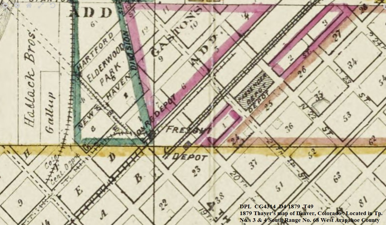 Note: It does not show the "new" D&RG Stone Freighthouse between 11th &12th St., nor does it show the DP/KP Depot at 16th St; both of which were on the earlier 1878 Map I posted above, and on the later 1881.. This is a normal thing when comparing the illustration of Railroad line location(s) correctly, and relying on, vintage Maps. However, they're all we have to work with. (2) That is a portion of the Sanborn Fire Map Sh. 15 1887 Denver. Post Denver Union..... (3) OR, maybe Stone for the recent construction of the Union Pacific Freighthouse(adjacent), not to mention the enlarged UP Roundhouse as well? fwiw I don't recall of where the Union Station stone was sourced from, maybe that is mentioned in Mineral Belt Volume I? Also, just what is the BV reference about? (4) Which photo, and where did I post a photo of a Cherry Creek Bridge? 
UpSideDownC
in New Zealand |
Re: Here is location of 1st Como Depot.
|
Chris,
my reference in the last post regarding What I think was the Boulder Valley line was of interest to me because it also captured George Sebastian's attention, pointing out the DSP cars. To the right of those string of cars are what appears to be a flat car with A frame in the middle. It would be ideal for moving floor, wall or roof frame sections. More recently, I began to wonder if it is a crane. I don't know now what to think on this. Further back though, I think I can barely make out the end of a snow plough. http://cdm16079.contentdm.oclc.org/cdm/ref/collection/p15330coll22/id/88627 Just stating more clearly. I believe that it is part of the former foundations of the D&RG Freight house that is sitting on Wynkoop street. They appear just short of the trees. I don't know anything about the UP freight house or turntable. Mine was speculation. And I further speculate. There are heaps of photos of old Como, Italy in the DPL. Como, Italy being famous for its stone building architecture. Less well known to me for its coal miners. The photo of the bridge you questioned is in the background of this photo. It does not appear to have structures each side as far as I can make out. Seems to be just flat which is what I was expecting. But I can not examine clearly. If the D&RG station was towed across that bridge it would have been overhanging the rail each side by around seven feet. Plus eaves higher up. A simple 3' piece of wood attached to the bottom plate of the walls would have stopped sideways slip. I anticipate things like turnout levers may have to be temporarily moved off coarse. Also, I am presuming that the Bridge is over Cherry creek. John. 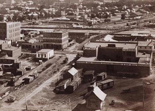
|
Re: Here is location of 1st Como Depot.
|
This post was updated on .
John,
the Bridge over Cherry Creek appears to me, as Kingpost Trusses such as this 1868 crossing at Reno. from Nevada Magazine MJ18 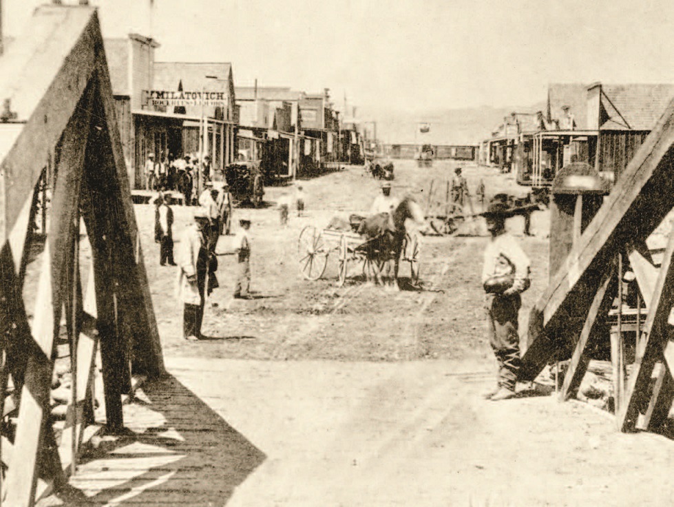 or possibly Queenpost Trusses with a lighter upper chord not quite so visible  DPL Z-5789 Platte River Denver 1868 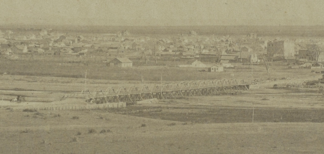 Either way any Building the size such as those under discussion, moved on a Flatcar across that bridge would require considerable cribbed blocking to clear the truss apex. Your vision of a snowplow is prescient; the first Rotary was built in 1883(in Canada), the D&RG not getting OM until January 1889. As to the "former foundations of the D&RG Freight house": I think you are seeing the cross-gauge transfer platform between the cars on Wynkoop. The Stone for the DUD was pinkish-grey Rhyolite quarried near Castle Rock delivered by the D.&R.G. with pink Sandstone accent stone from Morrison via the D.SP.&P. (Mineral Belt V-I) You could be right on an early Derrick; though at first glance(to me) appears to resemble one(or more) horse-drawn Cart tipped back up with the shafts angled upwards, too early in time to be a stationary Baler or Thresher, maybe another type of horse-drawn equipment. Have you considered the rational behind locating a building end-on to another RR Co's siding trackage to serve as a D&RG Depot? Conventional wisdom would suggest placing such a structure adjacent to the trackage owned by the D&RG. The references you have made to the City Directories, given the multiple locations noted, suggest in part to me, the D&RG may have just rented space in existing buildings on 19th St. to sell Tickets, after the removal of the two structures on Wynkoop, that shown in the Kansas Pacific Depot image. A footnote to that Train Order Board you see. As late as the 1970's the D&RGW RGZ left Union Station and only picked up its Orders at Prospect Junction. After reading that, I'd conclude that the trackage under discussion in 1881 and prior, was run under Timetabe and Yard Limit Rules. D&RG locos and train would have been serviced out at Burnham just to the South, backed to 19th St. for boarding and departure on Time. Inbound Passenger trains just the reverse and the Switchengine kept out of the way by Timetable directive. I doubt any Freights would have been run North beyond Burnham, just Transfer runs, probably by the Switcher assigned.
UpSideDownC
in New Zealand |
Re: Here is location of 1st Como Depot.
|
Chris said, "the Bridge over Cherry Creek appears to me, as Kingpost Trusses such as this 1868 crossing at Reno.
or possibly Queenpost Trusses with a lighter upper chord not quite so visible DPL Z-5789 Platte River Denver 1868 " Chris, are you able to provide me a link to the photo of the bridge please? And is that photo taken from the tower of the Union Station of the same bridge in the same location over the Platte river? Chris Also said, "Either way any Building the size such as those under discussion, moved on a Flatcar across that bridge would require considerable cribbed blocking to clear the truss apex." Yes, I agree and that concept is not feasible. I see in the photo in question a row of warehouse ends descending towards the river bank on a bridge very close to river level. It could be a bridge constructed much like this one was built near where I live and around the same era. Ballast excluded of coarse. 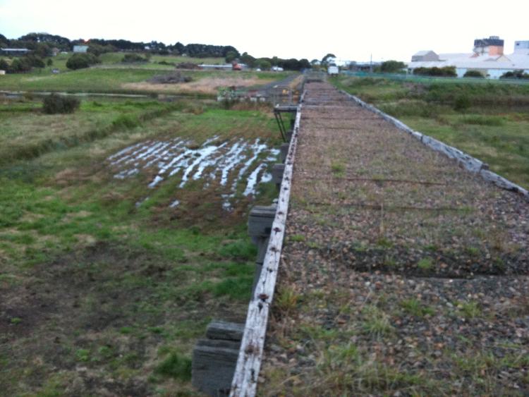 Chris also said, "Your vision of a snowplow is prescient; the first Rotary was built in 1883(in Canada), the D&RG not getting OM until January 1889." Yes. I have looked again at the clearer photo that you posted and I don't see a snow plough in the background. Chris also said, "As to the "former foundations of the D&RG Freight house": I think you are seeing the cross-gauge transfer platform between the cars on Wynkoop." I ask you to look again at the track location on Wynkoop Street. The track is not to the side of the Union Station and therefore the Station and Freight Depot must have been actually on Wynkoop street. And so I say again and more clearly, it looks to me as if what I see just before where the row of trees start that backed behind the Freight depot and Station, the remnants or stairs or a ramp that will have risen to the loading level of the Freight depot platform which would be such or the convenience of loading and unloading cars. Hence the raised Freight Building behind the station which it seems to me were identical end profile but just one higher than the other. And I also repeat, The end profile matches the Como depot. Chris also said, 'The Stone for the DUD was pinkish-grey Rhyolite quarried near Castle Rock delivered by the D.&R.G. with pink Sandstone accent stone from Morrison via the D.SP.&P. (Mineral Belt V-I)" Okay, thanks. Chris also said, "You could be right on an early Derrick; though at first glance(to me) appears to resemble one(or more) horse-drawn Cart tipped back up with the shafts angled upwards, too early in time to be a stationary Baler or Thresher, maybe another type of horse-drawn equipment." I see an A frame in the middle of a flat car. I don't see the things that you are suggesting. Chris also said, "Have you considered the rational behind locating a building end-on to another RR Co's siding trackage to serve as a D&RG Depot? Conventional wisdom would suggest placing such a structure adjacent to the trackage owned by the D&RG. There is an image taken in 1880 that appears not to show the end-on Gable building at that location. I shall post these later on." Thanks. Having realised that the Como depot had been end on to the track prior to being rebuilt in Como, I gained Kenton Forrest's book for reference. His book contained the plan that I have also obtained somewhere elsewhere identifying the D&RG station in the said location. His description of the station was that the station building was unusual because it was deeper than it was wide. And I note also. Where the Train order board seems to have exited the Como depot which sent me on this path is in the very exact location that it would be in the Denver Photograph. And it is difficult to deny that that is and extension. And I say that this was only a temporary location. And I say again that conditions were so bad for the D&RG according to Forrests book that it was explained that the D&RG moved into the Union Station even before the paint had dried. Such circumstances then may have required passengers to take a short walk to board. Such was certainly the case for a good time after the Union Station opened. Chris also said, "The references you have made to the City Directories, given the multiple locations noted, suggest in part to me, the D&RG may have just rented space in existing buildings on 19th St. to sell Tickets, after the removal of the two structures on Wynkoop, that shown in the Kansas Pacific Depot image." I don't understand?? The D&RG almost yearly sold tickets from a different location in the city somewhere. They would have sold tickets from the station, yes. But they would not have required a big ticket window such as the one in the baggage room wall in the Como Depot. I can do another post showing that the other ticket window between office and waiting room was installed after the fact, VERY CLEARLY. And every suggestion to me is that that ticket window was removed from the Buena Vista depot. Given that the Buena Vista ticket window was missing for reasons unexplained but the dimensions of the opening were the same as that of said Como depot ticket window. So they modelled the Buena Vista ticket window upon the original BV ticket window which seems to be in the Como depot. I can come back to this happily. 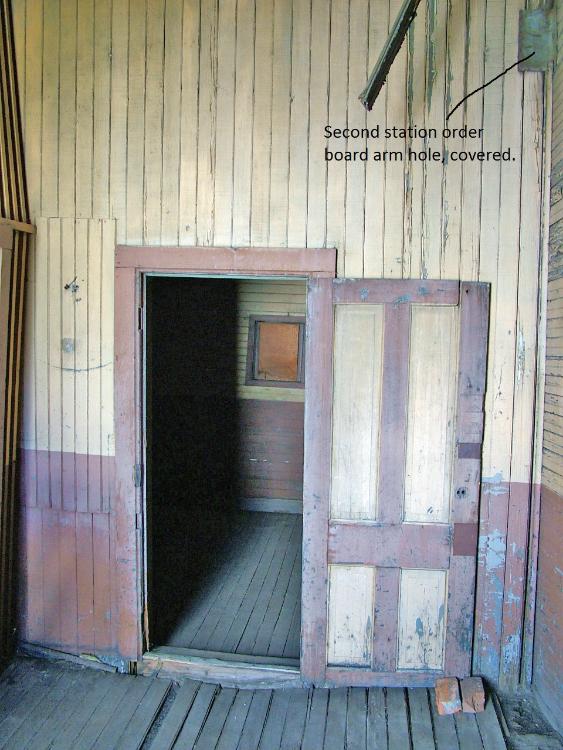 Chris also said, "A footnote to that Train Order Board you see. As late as the 1970's the D&RGW RGZ left Union Station and only picked up its Orders at Prospect Junction. After reading that, I'd conclude that the trackage under discussion in 1881 and prior, was run under Timetabe and Yard Limit Rules. D&RG locos and train would have been serviced out at Burnham just to the South, backed to 19th St. for boarding and departure on Time. Inbound Passenger trains just the reverse and the Switchengine kept out of the way by Timetable directive. I doubt any Freights would have been run North beyond Burnham, just Transfer runs, probably by the Switcher assigned." I will be guided by the City Directories, thanks. But maybe you can help me with this question. Was the Santa Fe sub leasing the D&RG station? I did read that but I am not sure of dates. Perhaps they also were desperate for better facilities, whatever. Regards the train order board. When the location of the station was on corner 19th & Wynkoop the hight of the TOB would be determined by eave hight, same as in Como. It seems to me that they did not bother moving the lever as it was but rather cut holes in the wall which otherwise are impossible to explain reasoning for in Como. But I repeat, those holes are the exact same hight as the pieces of window surround covering what would be insane to then deny will be a hole in the north wall. A hight which just happens to be the exact same hight as the cog bracket attached to the end of the horizontal shaft. You can go into denial as much as you want to. Me? I don't believe in perpetual strings of coincidences. I go looking for reasons. BTW, It was your friend Jeff Ramsey who provided the photos of the Rio Grand station to me. In the Narrow Gauge discussion group. That was when your other friend MHF realised that I knew something that he did not and so he posted to the group not to share information with me. An extraordinary manoeuvre. Just stunning. And then he made the bullet for you to fire. Which you happily did. It's okay. I read you both. Pity about discovering history would fall by the wayside next to the ego. Unbebloodybelievable! You are worth more than this Chris. And so am I. John |
Re: Here is location of 1st Como Depot.
|
This post was updated on .
In reply to this post by Chris Walker
If I'm looking at the "train order" photo correctly the Grand Hotel is on 19th street. And the train order board is on the east side of 20th. Using that scenario, Chris you are right. my re-review discloses that KP did cross 19th street. Jimmy |
Re: Here is location of 1st Como Depot.
|
I am explaining very clearly Jimmy where the station buildings were from documented evidence and how to check proof that as well.
Excuse me but you are now giving opinion without examining what has been explained already. Also, It was the business of railroads to move stuff. And it still is. Back in the day they had to build buildings by hand. They did not have the equipment to do otherwise. Not like today. They did not just tear down buildings every couple of years and build another because they needed to move. There is enough evidence to acknowledge that the railroads did move and restructure buildings. Furthermore, I have also pointed out that the Nation was broke from a Civil war. They made things to last given the costs and shortage of manpower and supplies. I don't know if the D&RG station was dragged across any bridges. But I suspect it from examining the structure of the Como depot. It is not really the point. But it is used as a point of distraction. To be denying that the Como depot is made up of assembled walls from various buildings And railroad cars is just ignorance. Even the President of the DSP&P HS acknowledged that fact and myself. "Cobbled together", were his words in the B&L. Why not acknowledge that much? And what I have shown you and will continue to do so because the amount of evidence is overwhelming. I will keep describing different sections of the depot and how it was assembled, as best I can. I am not sure what is going on actually. People that are raised with a certain set of religious or idealogical beliefs rarely change their views. Maybe it is that lack of logic. Perhaps it is just ignorance and arrogance that prevents acknowledgement. A determination to prove someone wrong just for the sake of it. Just like in the post before yours by Chris. It was a moderator of this group that saw what was going on in the narrow gauge discussion forum. He did not hold the same prejudices, observing what was going on. He asked me explain my observations here. And I feel confident that he is holding true to his character and resisting prompts to have me blocked. Thanks, John |
Re: Here is location of 1st Como Depot.
|
This post was updated on .
Actually John, nope!
I haven't the time today nor tomorrow to respond, (what I never got around to discussing after the http://c-sng-discussion-forum.254.s1.nabble.com/Desperately-Seeking-Signals-The-Saga-Of-The-Train-Order-Board-tp6678.html ) so let's see if you can pick up on the following  Size relativity. Size relativity.
excerpt from Colorado Railroad Structures V-II Klaas Gunnink 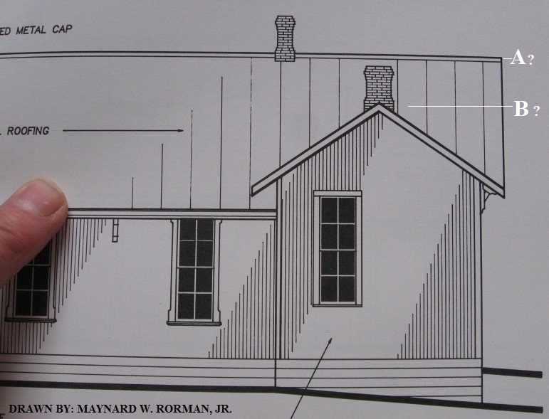 EDIT: Comparison of C&S Caboose in relation to Como Depot, height wise. DPL X-7518 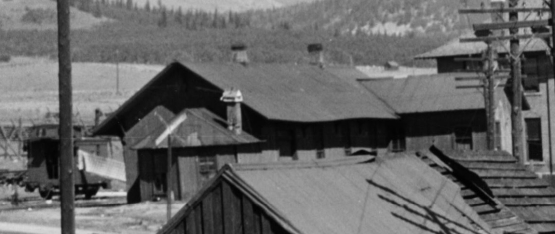 Comparison of Dispatchers Office, 24x50 (MACPoor) with Como Depot 20x60 (MACPoor) 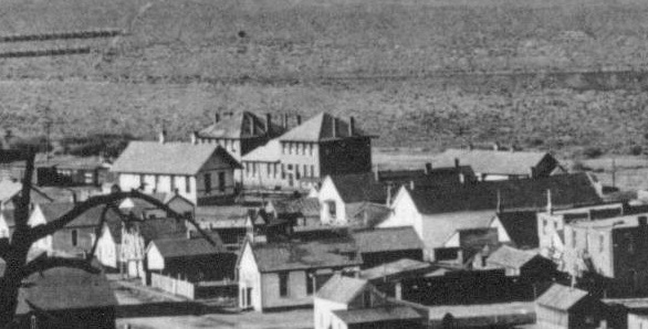 Comparison of (later)Boxcars and Jefferson Depot, 20x44 (MACPoor) 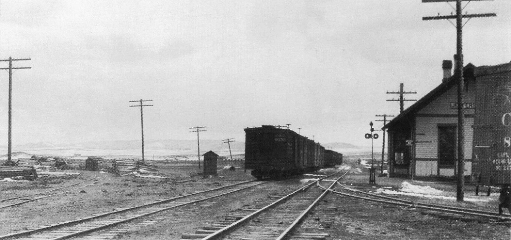 Comparison of (early)Boxcars and Webster Depot, 20x60 (MACPoor) Ted Kierscey Collection 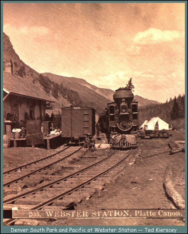 And of course....  A comparison of unknown size Building and adjacent S.G. & N.G. (early)Freightcars. DPL Z-11785  DPL X-25217 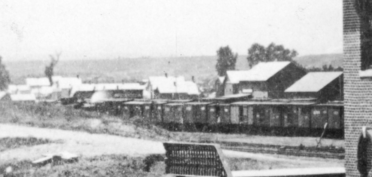
UpSideDownC
in New Zealand |
Re: Here is location of 1st Como Depot.
|
I need to acknowledge a few things, for the second time for those that may have missed it before.
I acknowledge that the map I posted at the start of this thread is not empirical evidence that it was necessarily the location of any depot. I acknowledge once again that narrow gauge railroads outside of Denver did not use train order boards necessarily in 1881. I reject Chris's assertion that train order boards were not used in Denver at this time. I acknowledge that Chris can not acknowledge ANYTHING AT ALL in what I put forward. Instead, Chris seems to be ejaculating in some kind of frenzy all over the classroom in order draw attention to hisself instead of the subject matter. For example, It was my observations of the Como depot and that it was formerly positioned end on to the railroad track that lead me to discover the buildings former location. In other words, I had the clues that lead me to the discovery. Is that a coincidence? 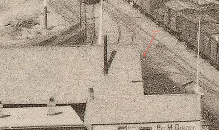 A link to the photo in the DLP photo below. The train orders board stands out far more clearly looking at the link. One would never ever find it unless they knew that the train order board signal would be there. (The building in question is slightly up rom the intersection of Wynkoop & 19th. Behind the Ben Delaney bar on the corner. http://cdm16079.contentdm.oclc.org/cdm/ref/collection/p15330coll22/id/88627 So is Chris correct in saying that train order board looks like anything but a train order board? Make up your own mind but I will continue showing empirical evidence in photographs of the string of events that have occurred. And I repeat that these are my objectives: 1, To show that the Como depot was made up of sections of buildings. (The President of the DSP&P HS has already acknowledged this regards the "Office 'extensions' ".) I will explain through examination of photos that the entire depot is comprised of sections of buildings and how they have been re-assembled. 2, To show that one of those buildings involved was the Denver D&RG station formerly. (I think I have adequately done that already for the open minded.) 3, To further discuss my suspicions that the D&RG station originated from across Cherry creek. 4, I have already explained the Pacific Hotel in a logical manner, far from the contrast of what was perceived. I could go on further in relation to that. I don't understand why Chris posted this photo of Maynard Rorman's elevation drawing. But I will just take it as a lead to explain what I do understand, leading from the photo. 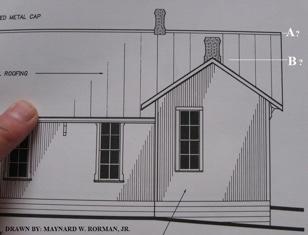 Chris has pointed out (A), the peak of the roof for some reason. I have pointed out that the roof was altered over the office, changing the direction of the roof line. I have also said that the depot was constructed against the first stage of the DSP&P hotel. (Before the kitchen extension). Yes, it is complex and possibly difficult to follow. I will take it slowly. 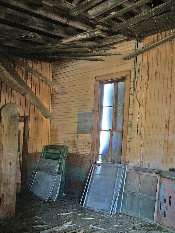 "Photo used by permission Copyright Ken Smith Photography All Rights Reserved.” www.steamandmorephotography.com In the photo above (Exhibit A) showing the direction of the (first and second extension) lining to the ceiling, in both (extensions), the ceiling lining are running in the same direction. According to the outside roofs, the direction over the (second extension) is correct. Over the first supposed extension the ceiling lining is running in the wrong direction. While here, I will begin explaining that the south side walls of the second extension are from the former D&RG station building. The extension of wall visible is a half wall of the former depot. Dont let it defy comprehension, it took me years to understand all this. The window in the very internal corner linked to the second half of the end of the prior D&RG station building wall in question. This plan from the owner of the building which I have drawn upon will help explain. Exhibit (B) below. 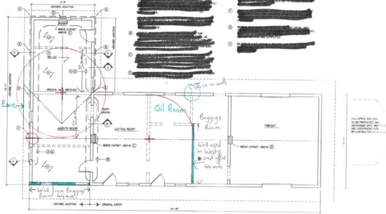 I have mentioned that the wall from the sleeping quarters at the rear of the office was exactly half an internal walls distance away from the rear of the depot. I have drawn a full circle in red demonstrating the circle touching both the centre line of the depot and the sleeping quarters wall. And I repeat again. The dividing wall between office and sleeping quarters is structural. While I am here, I will just point out the missing wall drawn in green in the "Baggage Room" and how it has appeared at the west end of the office, also drawn in green. Corresponding with the owner of the depot, he explained that Older Than Dirt tried to pull the (Second Extension) back square to the rear of the depot. It could not be done and OTD concluded that the extension had never been square. By about 1.5 inches, from memory. My take on this is that the East and West ends of the office having originated from different buildings were a close enough length?! Still looking at the plan above now. I have drawn a red circle in the North wall under the roof ridge line pointing out the join in the walls in the photo below which appears in the wall area painted green. Exhibit (C) for reference. An abstraction of a larger photo. "Photo used by permission Copyright Ken Smith Photography All Rights Reserved.” www.steamandmorephotography.com Exhibit (D) below. 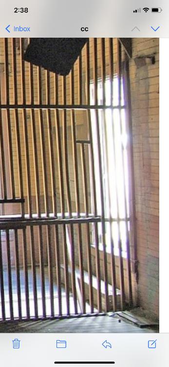 Note: these two half walls referenced above in the North wall of the Como depot were internal walls previously. The windows and window/door were added later. The window/door being added as the depot was constructed against the first stage of DSP&P hotel is my suspicion. Thus the unique style of architecture of this once window/door in the building. Below, exhibit (E). "Photo used by permission Copyright Ken Smith Photography All Rights Reserved.” www.steamandmorephotography.com 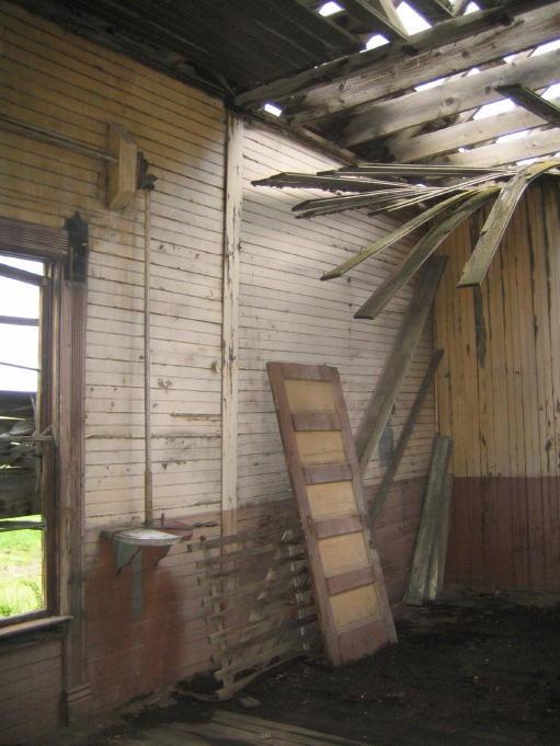 Below is a photo of the North wall from outside. I can't recall in which public forum I found this photo. Note that underneath the clapboard is a layer of packing cases. Note the external board for the telegraph wires. Exhibit (F).  As indicated before noting the packing cases attached to the north wall, I believe that prior to the clap board, wood shingles were fixed to cover the packing cases on this wall. Photo provided to a silent member of the DSP&P HS. Exhibit (G). 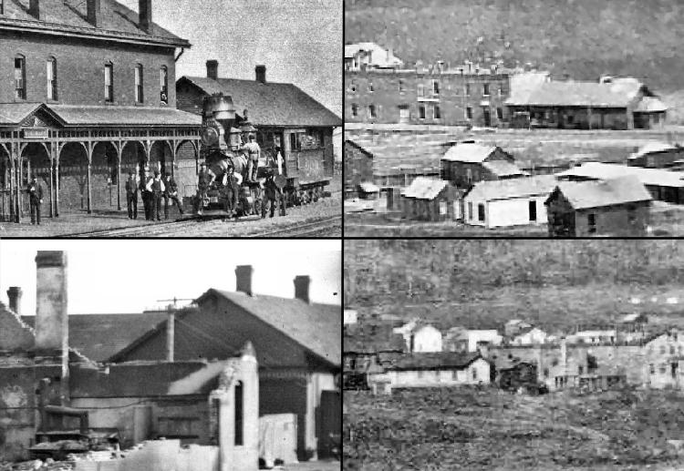 Notice in the photo above that the North wall looks more like wood shingles such as on the roof rather than clapboard. This would hide externally any prior evidence of an external doorway. Notice the line of power poles passing between the depot and hotel. Logic would tell you that the external board for the telegraph wires was applied after the depot was moved away from the hotel. Below again the photo inside of the the telegraph wires board. "Photo used by permission Copyright Ken Smith Photography All Rights Reserved.” www.steamandmorephotography.com. Exhibit (H). 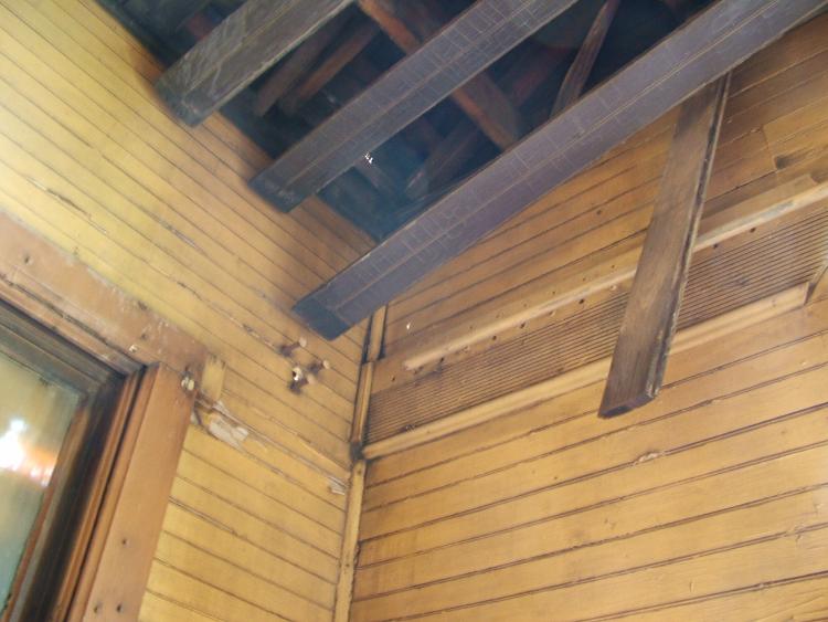 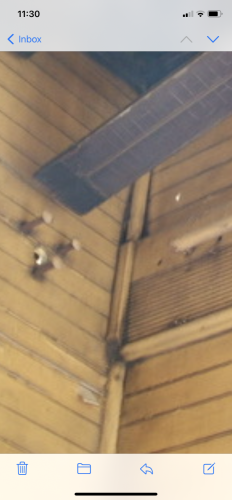 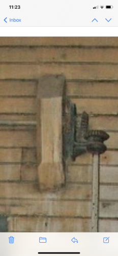 Notice that the sections of architrave or window surround are attached straight into the corner prior to any corner bead. This is in contrast to what has appeared outside. Also notice the exact positioning of these three pieces of wood in contrast to both the cog bracket of the TOB and the hole for the TOB shaft to pass through the wall. The hole is two and a bit wall cladding grooves down from the telegraph wires board top and almost three grooves up. Contrast that to the the cog bracket and associated shaft as well. EXACTLY the same hight. I will explain again. The top flat piece of wood is now upside down and from the underside of a window sill. That is upside down can be confirmed by the cove cut into the end of the wood to the right. Further, it still has the bead attached to it that would have previously butted up underneath the Bullnose of the window sill. Below that, the middle piece is a piece of window architrave, with still the mitre on the end. The third piece below the architrave is also from a window. It is not identical to that used in the window to the left, meaning a different style window. But it was just enough to cover the hole for the TOB cog bracket underneath. Understand how EXACLY precise this is. Which leads me to my discovery in Denver, My approximate date late (1881) of when the buildings were moved to Como and hence why I believe the window architecture was removed from the Gilman during the process of joining the DSP&P hotel to the Gilman. Below, Exhibit (I). The building circled is in the same location that I have pointed out previously. The roof from this building and the rear wall of the sleeping quarters were both used in the office construction in Como. 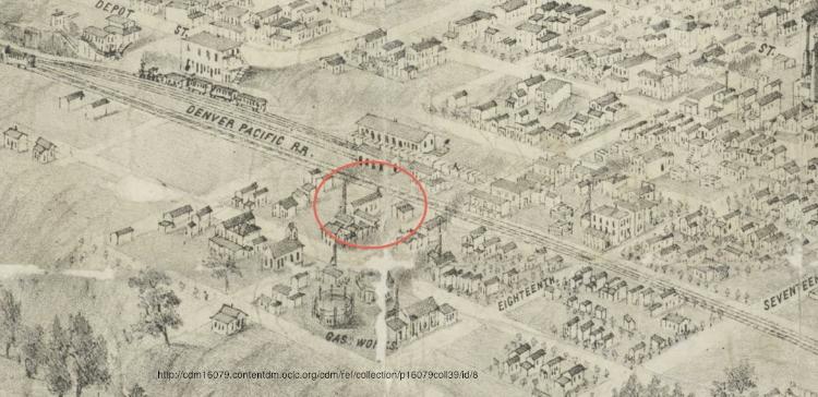 Notice that there is just enough room for a building to slide in between it and the Ben Delaney bar. Also notice that the end that would be facing the track appears to have had a chimney. As in the following photo with smoke coming out of the Sleeping quarters chimney. Exhibit (J). Various sources. One probably being the President of the DSP&P HS. 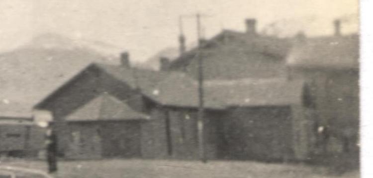 Notice the line of telegraph poles. One pole being between the hotel and the Pacific now. Notice the overhanging roof of the Pacific hotel which is why I say the Depot had to be moved a second time in Como to allow for that construction to take place. Just a little bit clearer and we would have been able to identify the window at the end of the 98.5 ft hallway. And so I now return to the Office roof and the Southern wall of the office and Sleeping quarters."Photo used by permission Copyright Ken Smith Photography All Rights Reserved.” www.steamandmorephotography.com Exhibit (K). 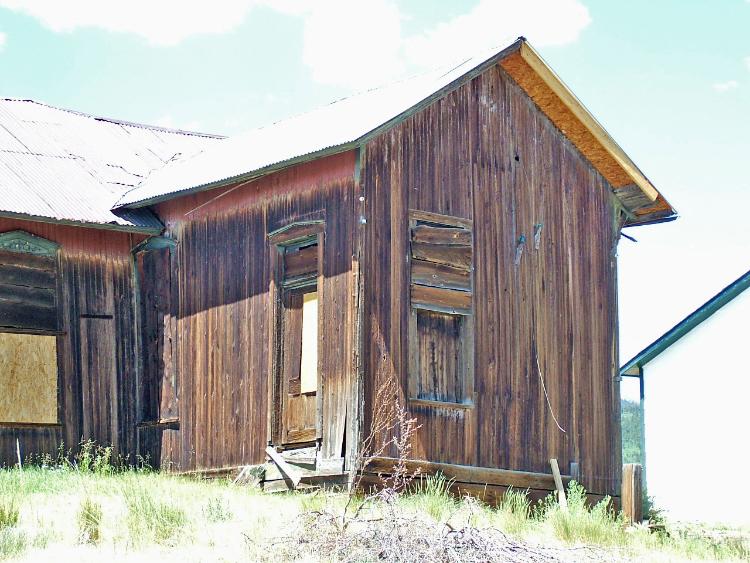 Notice the dogleg in the roof from inline with the wall dividing the office and waiting room levelling once again at the roof ridge line of the office. From there it goes horizontal once more to the outer eave which happens to be in line with the rear office extension. I have already said that the depot was built against the DSP&P hotel and at that time the roof ridge line over the office ran full length east west. Such a roof sloping towards the hotel would have been a snow trap and after one winter the roof would need to be altered. Hence the new roof appearance over the 1883 photo. I can explain the dog leg more clearly using the next photo. Exhibit (L). "Photo used by permission Copyright Ken Smith Photography All Rights Reserved.” www.steamandmorephotography.com 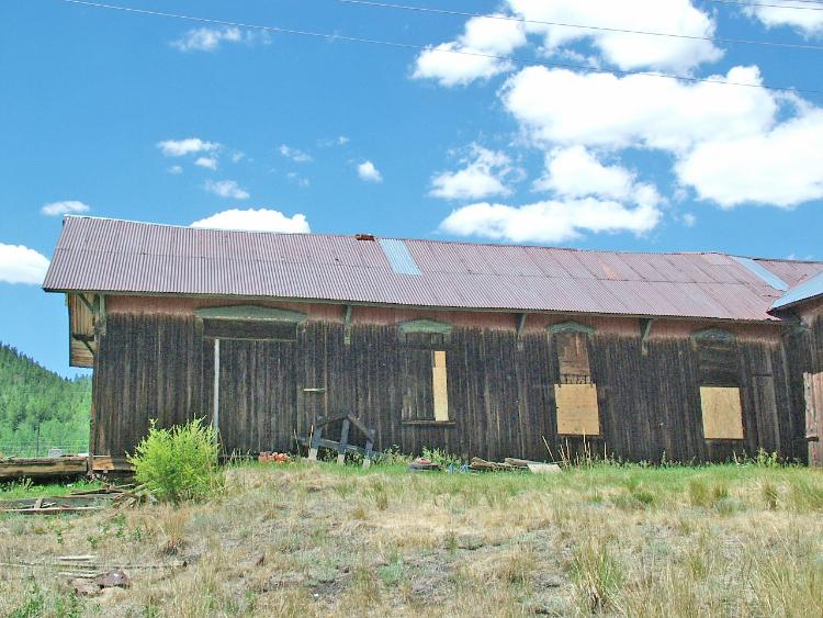 It appears that this photo was taken before the floor of the Switchman's hut and I guess the vestibule on the other side were removed. But it is this odd piece of framework behind the freight room that I wish to draw your attention to. The two pieces top end appear to be the same pitch as the roof. Below that point of the described roof pitch is a piece of wood running crossways. If that piece of wood running crossways was a part of the office original roof ridge line then the peak above it would be inline with the depot roof. This what I think happened actually. The roof starting from above the office waiting room wall being extended to the roof ridge line of the office. There, it stopped with an end much like what is seen in the assembly behind the freight room. This probably happened as the depot was built in Como. The then further revamp of the office roof done as the snow issue was realised. Enough time however for the roof shingles to fade giving the appearance that the office was an extension. Returning now to the external wall south side of the office, Exhibit (K). There are not quite two half walls here. These are genuine end walls of the D&RG station unlike those in the North wall described previously. Notice that the door to the sleeping quarters was once a window opening. I can identify this from short sections of cladding above the doorframe. The external windows and doors in the depot are generally level on top. This doorway is lower than the window to to its left and in the corner. The infill above the door makes its former opening level with the window. And I did note that the half wall extending from the rear of the depot to the office sleeping quarters wall was enabled by the sleeping quarters wall acting as a brace. I say again that this wall is from a boxcar, same as the walls of the Switchman's hut. I say again that the windows of the Switchman's hut were removed from the Gilman. Photo extract is of the Pacific Hotel in the DLG era. DPL. 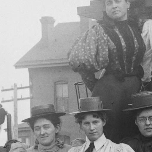 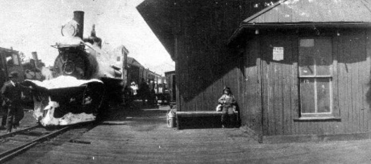 Chris should be able to verify from the Rorman drawings the width of the of the roof over the the Switchman's hut is the same width as the width of the roofer the sleeping quarters. Despite the eaves of the Switchman's hut being lesser than that of around the Sleeping quarters. I put that down to my suspicions that the Switchman's hut was also made of railroad cars. Same as the office/sleeping quarters wall below which only extends up framed a similar distance. 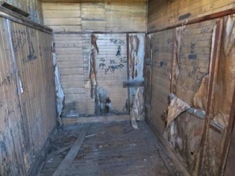 Next time I post I will focus on the main depot walls. So, this is how I string anomalies together until they make sense to me. I hope you were able to follow. John |
Re: Here is location of 1st Como Depot.
|
This post was updated on .
John,
Insults and name-calling. I'd hoped for better this time. I was wrong. When are you going to realize the audience aren't blind zealots determined to gaslight you? That rambling ideas, avoiding questions and tossing insults isn't how you win converts. Clearly we're trying. But what about you? This is like Groundhog Day, the same slow train wreck over and over. Enough: You've lost my interest.
Dave Eggleston
Seattle, WA |
Re: Here is location of 1st Como Depot.
|
Dave Eggleston wrote,
"John, Insults and name-calling. I'd hoped for better this time. I was wrong. When are you going to realize the audience aren't blind zealots determined to gaslight you? That rambling ideas, avoiding questions and tossing insults isn't how you win converts. John Droste wrote So, this is how I string anomalies together until they make sense to me. I hope you were able to follow. John Clearly we're trying. But what about you? This is like Groundhog Day, the same slow train wreck over and over. Enough: You've lost my interest. Dave Eggleston Seattle, WA" ------------- I said, "So, this is how I string anomalies together until they make sense to me. I hope you were able to follow." I think it is normal practice after making a presentation such as my last post to have a Q&A session. Perhaps I should have applied a question mark at the end of my "I hope you were able to follow.", sentence. It was a statement intended to be courteous. Applying a question mark, making it it a question could in my mind intend insult. And that was and is not my intention. I am only here for one reason and that reason is not about me. Before the Como Depot was renovated, I realised that the history of Como was misunderstood and I set about to uncover the reality behind what was not making sense to me. This continues to be an ongoing process as a matter of personal interest and personal mind growth and not for any other reason. I did understand however that with the renovations of the Como Depot history would be lost leaving me as the only person so it seemed that might be able to rediscover the truth. And as not anyone at all has been able to acknowledge anything at all that I have written of, it seems to confirm my concerns. By example, 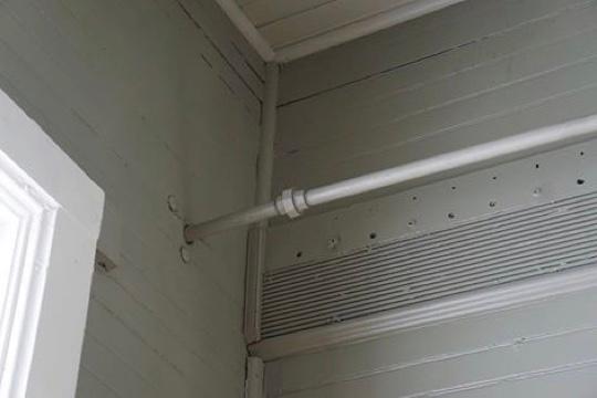 The bead which I say butted up underneath a window sill has been removed. Something which I consider of important historical interest. It is clues like this and many more that are now lost. Regards unanswered questions then. If the implication is that I am not giving credit to sources of photos then it will be because I can not remember the source or the supplier has expressed they wish to remain anonymous. There is a comment Chris Walker made pointing out the date on a photo being 1882. Chris will know better than I that the Union Station was completed after two years construction that the station opened for business in May-June of 1881. The four links that I will attach beneath indicate that the four photographs were all taken on the same day. The cars in the KP yard are the same in the first two links. Three photos show the undeveloped surrounding grounds of the Union Station. That will not have lasted until 1882. http://cdm16079.contentdm.oclc.org/cdm/ref/collection/p15330coll22/id/88627 http://cdm16079.contentdm.oclc.org/cdm/ref/collection/p15330coll22/id/84036 http://cdm16079.contentdm.oclc.org/cdm/ref/collection/p15330coll22/id/84035 http://cdm16079.contentdm.oclc.org/cdm/ref/collection/p15330coll22/id/88640 Chris knows this but he makes the note for reason. It is part of his attack upon me. And which for the greater then, I ignore. Dave, if I have missed other questions I ask you to draw them to my attention. I reject your assertion sorry that I think everyone in this discussion forum is a zealot. But like in every community, I believe there will be some. That said, I can empathise with your loss. Apart from a few acquaintances made and my personal interest in discovering truth, I have completely lost interest in modelling the C&S or anything preceding it. I have lost the people that have an interest in same. My only remaining interest is the history of Como, which I have previously stated. I do not doubt or need to question that your loss or my loss is my doing. I am not a perfect person. I have failed you, for example. I just do the best that I can with what I have, at the time, as far as I can possibly be aware. John Droste Far removed, Australia. |
Early Wynkoop St. with illustrations and notations.
|
This post was updated on .
In reply to this post by Dave Eggleston
EDIT: I started off this post in error: see apology: http://c-sng-discussion-forum.254.s1.nabble.com/Here-is-location-of-1st-Como-Depot-tp18859p18919.html
John, This last location, the building you think has a Orderboard on it and with a platform in front, isn't the structure Dave arrowed. This standard gauge yard photo you rely on is taken North of Union Station(1st) and the building in question, of the one said to be at 19th & Wynkoop is actually behind the more distant(shorter) Pole  which is why I had previously posted the DP-KP Union Station photo, to try and help you out. That building, from your photo, has been there all along. which is why I had previously posted the DP-KP Union Station photo, to try and help you out. That building, from your photo, has been there all along.
Power poles and Train-Order Boards are in the future. You've been posting links to various maps and pictures but you don't seem to see the details, and relevance; that Platte River bridge being one of them. Jeff Ramsey and I have never met, he may not appreciate you suggesting we're friends. 1874 Illustration of Denver DPL CG4314 .D4 1874 .G53b 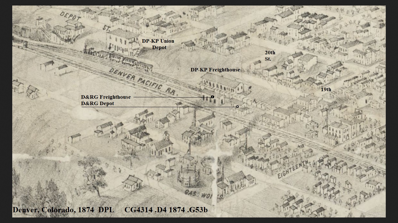 I took the liberty of highlighting the gauges this time.  1878 Map of Denver DPL CG4314 .D41878 .W5 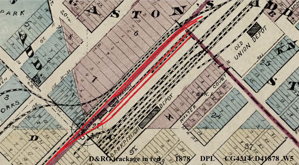 The DPL X-25217, enlarged, unSEATed version for definition. 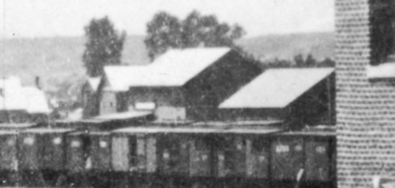 I took the liberty to give it the Structural Element Analysis Treatment  DPL X-25217 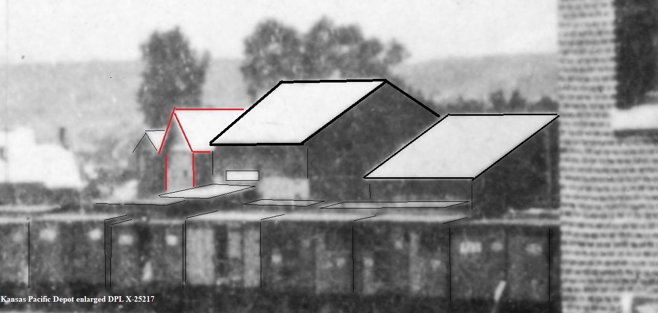 The outlined in Red structure takes on an appearance to be a completely separate building behind. Note how these considerably all stand out above the Freightcars, have lesser pitch to the roofline than the others which brings me to ask...... Did you ever stop to consider the comparitive size aspect, and adjacent details in relation to the height of the building in question? In the WH Jackson Denver Panorama North picture, you've often stated you used the Track gauge to determine length; did you use the D.P. or the D.&R.G. to arrive at your calculation? S.G. is 1.57 times the width of 3'. What about the early D&RG freightcars(10ft high: 24ft-26ft long) adjacent, surely you see the smaller size vs the 1880 S.G. right there? That's why I went back to my earlier post, and included the McPhee & McGinnity Jackson image, which has better s.g. vs n.g. proportional definition. The 16ft wide Alley by the Hotel leading to the Germania House sure would help as well. The building behind Delaney's has a steeper roofpitch than those of the D&RG parallel with the tracks on Wynkoop St. One more observation; The 3-Rail(dual gauge) that appears North of the building behind Delaney's I doubt would be there prior to 1879 as the Colorado Central had no n.g. East of golden to warrant the "break of gauge" interchange capacity. We've all become very familiar with this wonderful image, or have we? DPL WHJ-10461 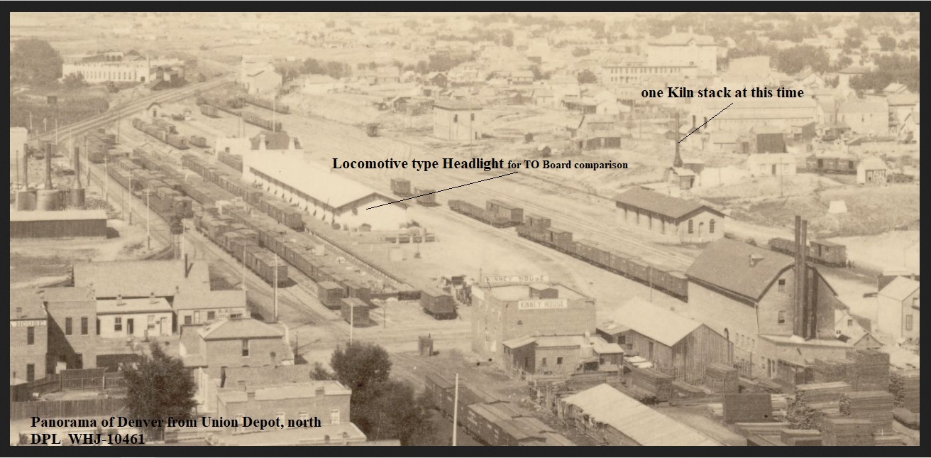 And this.....DPL WHJ-10661 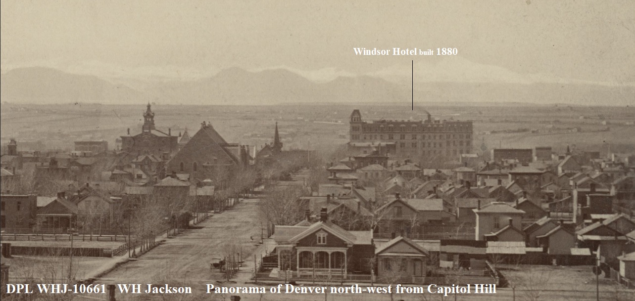 DPL Z-11774 EDITED Picture: 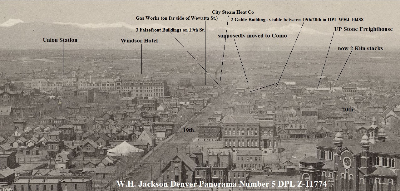 Now back to Como.... A little creativity gives us this, in case you missed the photo in my previous post. I can't help but notice the height size difference. 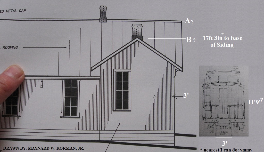 DPL X-7518  Migrating a Structure 80 miles into the mountains and reducing the proportions to just a little extension, seems very wasteful indeed, especially given the carloads of Lumber headed the other way, back to those Lumberyards alongside the new Denver Union Station; Plausibility?
UpSideDownC
in New Zealand |
Re: Early Wynkoop St. with illustrations and notations.
|
Hi Chris,
I may not finish tonight but I will make a start. Yes, as before. I am linking the building two buildings with the arrows. 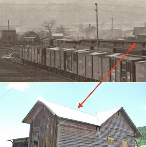 http://cdm16079.contentdm.oclc.org/cdm/ref/collection/p15330coll22/id/88627 JD wrote, "As mentioned previously, http://c-sng-discussion-forum.254.s1.nabble.com/History-the-ego-identity-tp18831p18835.html the building behind the power pole was the D&RG station its second location, to my knowledge." Yes Chris, I will show that photo again.   Chris, I will make three references here, to the photo above. The D&RG freight house is to the far right. I have come to the conclusion myself today apart from your statistics that I can not see how a part of this building was moved to Como to become part of the Como depot. I will address this matter more in a few days. (We are forever learning.) In line with the KP station, on the hill, behind that pole is the building that you have referenced. It can also be seen in the now familiar W H Jackson photo. Third reference. Directly in the middle of the last two references are two buildings side by side with square facades above the roof. I am not as clever as you making notes on photos so forgive my efforts. These buildings are on 19th street and I will point them out in the next photo. 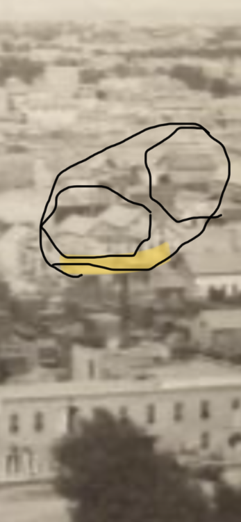 Actually, two circles within one circle. The lower circle shows the rear of the facades of the buildings in 19th street. The other small circle surrounds the building that I believe you are confusing with the building I am interested in. The building I am interested in is not there. But you can see everything more clearly here. Identify that tall building with the Cape cod type roof while you are at it, close to South West corner of 19th & Wynkoop. http://cdm16079.contentdm.oclc.org/cdm/ref/collection/p15330coll22/id/88627 Chris, your photo pointing out the structures beyond the D&RG freight house. 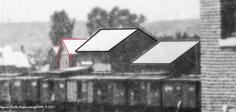 My photo showing the location of those two buildings. 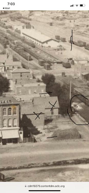 On Wynkoop street, approximately where the the rear of the D&RG station ended I have circled a structure that appears bit like an outhouse. It is not. I asked my friend Doctor Who to surveil the area for me. That is her Tardus. Regretfully she was not able to spend much time there as she was called away on and emergency. 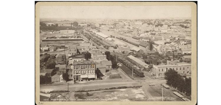 The grounds across the road are the undeveloped grounds of the Union Station. I will have to continue tomorrow. John |
Re: Early Wynkoop St. with illustrations and notations.
|
" Chris,
Thank you to drawing my attention to matters that I am ignorant of once more. You have shown me another location of the depot/s of the D&RG. 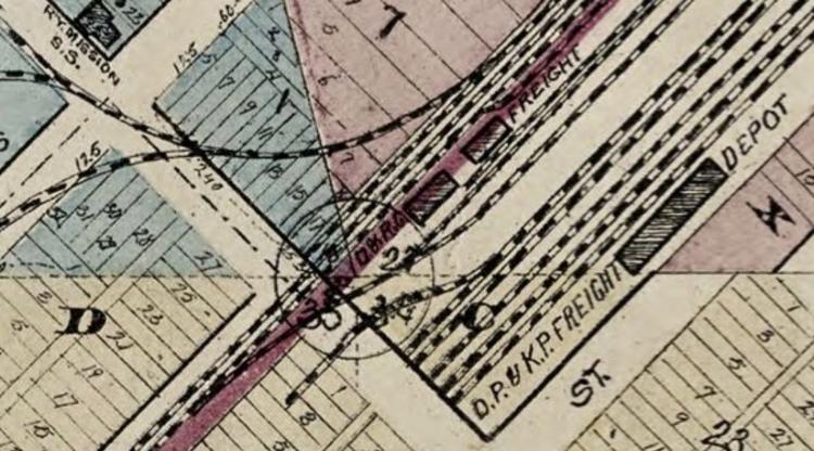 It answers why I did nor recognise the location in the Denver city 1873 directory, 1873 freight and passenger SOUTH EAST CORNER http://digital.denverlibrary.org/cdm/ref/collection/p16079coll28/id/6701 Your map was dated 1874. I guess the City Directories would be near the start of the year for in 1874 the depots were no longer listed in the same location. They were in the location that I pointed out a few days ago. 1874 freight and passenger south west corner http://digital.denverlibrary.org/cdm/ref/collection/p16079coll28/id/6989 Obviously by http://cdm16079.contentdm.oclc.org/cdm/ref/collection/p15330coll22/id/88627 the freight depots were no longer there. I guess they just tore them down after a year or so. Or maybe they just reused them elsewhere. I think you indicated that there would be many more empty cars heading into the mountains than was returning. 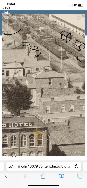 For the convenience of others as well as Chris, I have drawn in some depot shapes on the platform where the depots are not. In the top left I have also circled in where I believe is a flat car with an A frame upon it. Ideal for moving walls, floors and the like. I have also circled in the train order board once again. And Chris, I have also circled some dual gauge track that a narrow gauge locomotive is on, ready to enter Wewatta street and the Union Station for some reason. And I drew in some standard gauge line as well which crosses the road to the south west side, stopping in front of buildings there. I am familiar with dual gauge. It was what drew my attention to the Denver station in the first place when I decided to take up modelling. I decided on modelling dual gauge because I did not wish to enter into a hobby that would become boring. 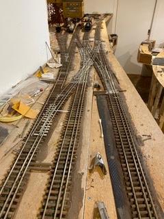 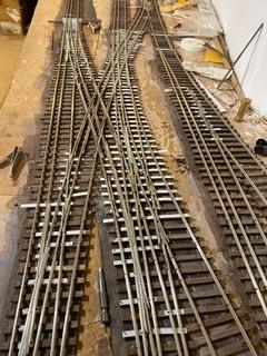 It is not boring. Still under construction, this is DCC with the back broken, two consecutive crossovers. The rest is easy. I wonder where the D&RG station was prior to 1881 for it is not located in the photo that we are now so familiar with. But hey, going backwards: 1882 directory Page 31 1881 directory page 25 http://digital.denverlibrary.org/cdm/ref/collection/p16079coll28/id/9690 1880 annual directory page http://digital.denverlibrary.org/cdm/ref/collection/p16079coll28/id/8670 http://digital.denverlibrary.org/cdm/ref/collection/p16079coll28/id/9102 Chris, you have read my notes on the telegraph wires board in the Como Depot. What would be the odds? Three pieces of window frame attached to the wall even before a corner bead to stop the draft was attached, times, a power pole being established outside year later, times, the three pieces of window surround being at the very same hight as the train order board got bracket and I mean absolutely exactly, times, two holes also the exact same size in the walls along the walls running running in the other direction, also exact same hight and and dimensions, 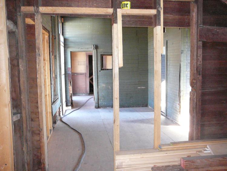 (top left corner of green wall) , times, all the other information I have gone into regarding the office area and the actual depot yet to come, times, actually finding a reference to a station end on to track of what?, not more than half a dozen potential candidates, times, following my nose and actually finding a building that fits the description in the D&RG local. What are the odds of all those things coming together? Millions, billions to one? It is not something that a rational person can deny! Moving on then. 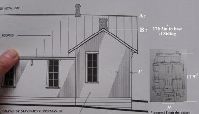 I am not sure what you are getting at with the above photo. Morman's measurement for the rear of the sleeping quarters was 13'9&3/4" wide. 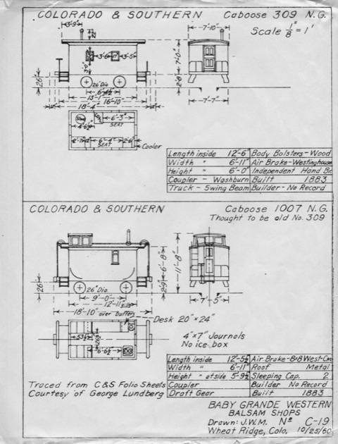 But two cabooses could almost fit in the width of the wall. Whatever, it just does not matter. One last thing before returning to explain the anomalies of the Como depot. You pasted a photo of a trestle bridge. If that was the bridge that was washed away then it is no wonder. I mean, how could a trestle bridge like that collecting everything that was flowing downstream possibly survive? Surely anyone would think twice before building same again. |
Re: Here is location of 1st Como Depot.
|
In reply to this post by John Droste
I just have to ask: Just where, in what post did I say the 1882 Date? I have checked back at the top of this page, can't find that.....wonder if you meant Jeff Ramsey? In another place and time? 
UpSideDownC
in New Zealand |
Re: Early Wynkoop St. with illustrations and notations. An Error Ocurred.
|
In reply to this post by Chris Walker
I owe John an apology.
I was unaware that the image presented was a wide-angle view, that was cropped & enlarged presenting a distorted viewpoint. I should have gone looking for the full image first instead. The other part of my Post stands, especially the Red outlined structure enhanced from the DPL KP Depot image(X-25217). Are you comparing these two? 
John, This last location, the building you think has a Orderboard on it and with a platform in front, isn't the structure Dave arrowed.(wrong conclusion) This standard gauge yard photo you rely on is taken North of Union Station(1st) and the building in question, of the one said to be at 19th & Wynkoop is actually behind the more distant(shorter) Pole (wrong conclusion) which is why I had previously posted the DP-KP Union Station photo, to try and help you out. That building, from your photo, has been there all along.
UpSideDownC
in New Zealand |
Re: Early Denver D&RG with illustrations and notations about Structures.
|
This post was updated on .
Finally,
The next images showing the famous "TO Board" building and the Falsefront lettered for Delaney's(1881), were there in previous years, yet one somehow being the D&RG Depot and moved. I found it interesting the "artists rendition" Map of Denver 1874 actually showed verandahs/awnings on the D&RG Depot, something barely visible in the Kansas Pacific Depot view. Someone really put a lot of detail into that document.  Let's take another look...and note what Structures appear.  , John: Note the size of all three Buildings* over the adjacent Cars. , John: Note the size of all three Buildings* over the adjacent Cars.
DeGolyer Library, Southern Methodist University Ag1982.0086 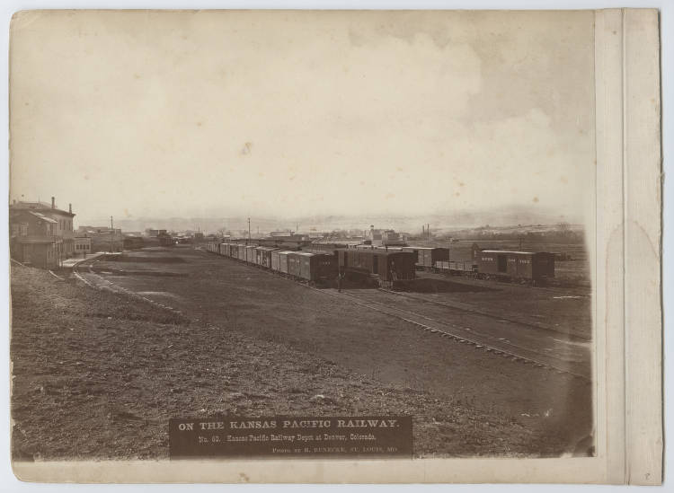 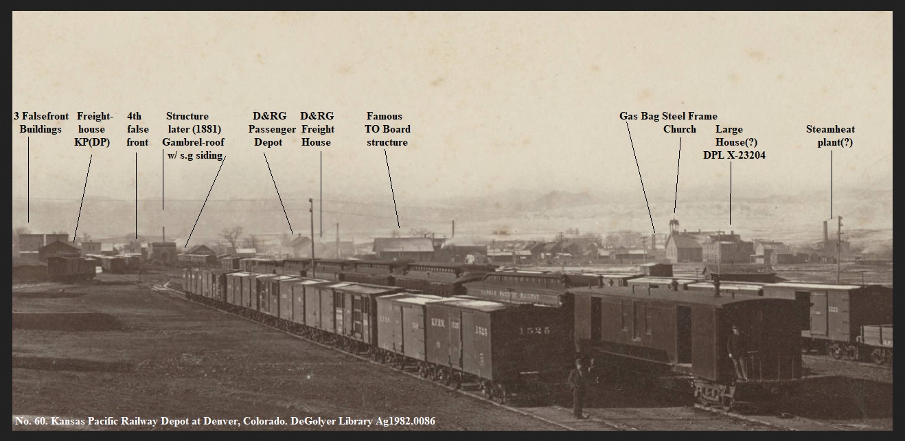 DPL X-23204 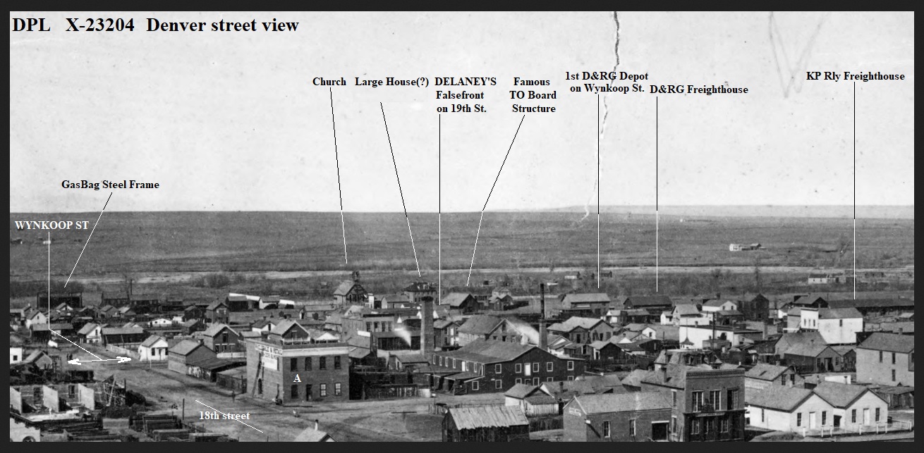 EDIT: I see I missed the anotation for Wazee St where the diagonal arrow is below the dropline from Wynkoop notation. And I have labeled 17th St as 18th. 18th is barely obvious there so a minor Error. And "A" building is on Holladay St.(I missed out that too! Enlarged; note the Clerestory Car(left of Stack), and Flat-top Car at the Depot(best examined in the DPL). 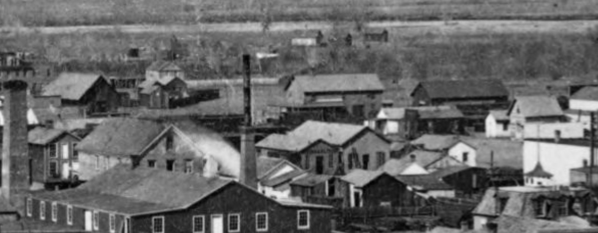 This next photo is of the South Denver magnificent Stone replacement constructed sometime later but before the Denver Union Depot. I've never seen of a date for this. The D&RG obviously built this as a Passenger&Freight Depot more suited to the fast growing Denver City. It reinforces the view expressed many times to John that his theory that the D&RG Wynkoop Depot was rotated 90 degrees and moved off line before the D&RG moved into DUD, is just ......... From Tivis E. Wilkens, Colorado Railroads, Pruett Pub. 1974. pg24. 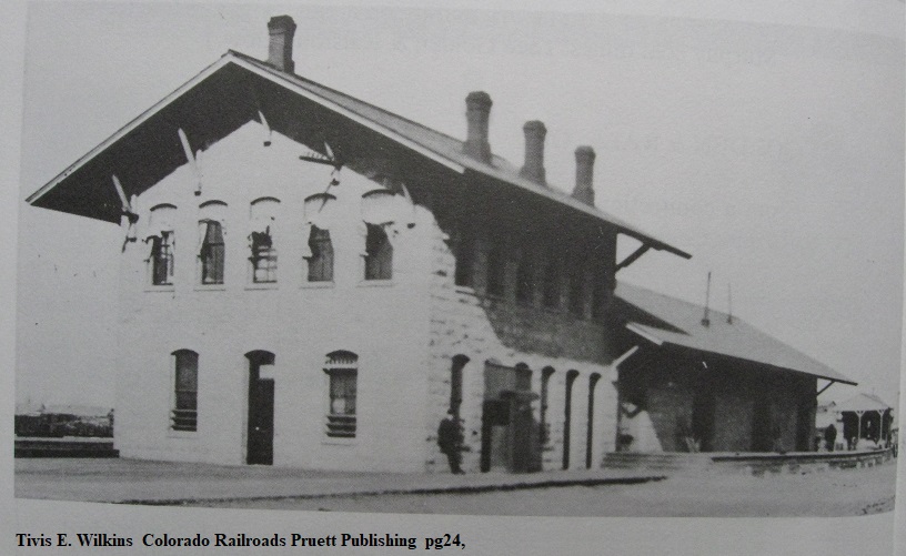 * It has always struck me as odd, as to the overall impression that Como had a Depot that looked like it was S-scale, on an O-scale layout. 
UpSideDownC
in New Zealand |
Re: Early Wynkoop St. with illustrations and notations. An Error Ocurred.
|
In reply to this post by Chris Walker
John,
This last location, the building you think has a Orderboard on it and with a platform in front, isn't the structure Dave arrowed.(wrong conclusion) This standard gauge yard photo you rely on is taken North of Union Station(1st) and the building in question, of the one said to be at 19th & Wynkoop is actually behind the more distant(shorter) Pole (wrong conclusion) which is why I had previously posted the DP-KP Union Station photo, to try and help you out. That building, from your photo, has been there all along.  --------------------------------------------- Chris, I am really really struggling to follow you just now but I know why. You are putting duty before honour. I am very aware that the building with the red arrow pointed towards it in Denver is not the building that had the train order board. I have never thought that. Your second paragraph, I can only guess at. I will try to answer guessing at what I think you wanted to say. I will start by copying and pasting Jeff Ramseys's response before he was warned by MHF not to share anything with me, (Duty before honor). Jeff, "Map, 1878-79 showing layout Of Kansas/Denver Pacific passenger and freight, Denver & Rio Grande and Colorado Central depots. In 1879 the Denver, South Park & Pacific was also interchanging with the Colorado Central thus the second bridge over cherry creek (Wewatta St), the D&RG being the first being rebuilt after the flood of 1878 (Wynkoop St)."  Just note that the RG "depot" is marked north side of the track and the "freight" South side. Jeff again. "Interesting subject. I think the D&RGRy had 4 different Denver stations before the completion of Denver Union Depot in 1881. I need to review some research material which I have in storage, perhaps I can post next week in detail. A big game changer was the washout and destruction of the bridge over Cherry Creek in 1878. Bo a Google search on D&RG annual reports 1871-1883 there are some building reports and valuation." And Jeff again, "The second D&RG station is left of the telegraph pole, beyond the Kansas Pacific passenger train, 1873." 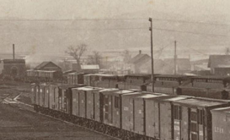 Chris, I have always understood that the D&RG station was located on the far side of 19th street. I think we agree! And the D&RG freight depot directly behind it. Hence the two buildings that you pointed out from the view from behind the KP.  And so the the buildings I marked with crosses are in alignment with the back of the D&RG freight depot.  Line all buildings up with the KP. Not really relevant but acknowledging the building with the red arrow was there before the railroad, it seems. A bit hard to see but it is there. 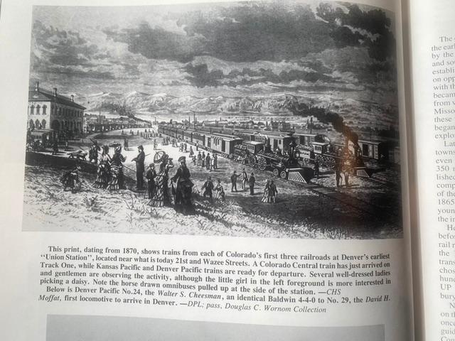 Perhaps I did not explain it as well as I could have previously. The building with the red arrow is here located in the red circle. The important thing to note to stop the confusion about this being the building with the train order board signal is that there is a space between it and the Ben Delaney building on the corner.  I now identify the D&RG freight buildings across the road for the first time, thanks. But we return to this building now, the building that has no gap between it and the tiny Ben Delaney building. The building that I say was the D&RG station previously located south west corner of 19th & Wynkoop streets. Directly across the road from the Ben Delaney building if it were not for the building being actually ON Wynkoop street instead of NEXT to it, as buildings usually are.  (adaptation of the old schoolboy phone call prank. "Hello, do you live on Wynkoop street?" "Well get off! There is a train coming!" I acknowledge that the photo was taken from the roof of the Union Station. This was mentioned in the pages of the Kenton Forrest book that I just posted. I remember many years ago ago a discussion on whether there was a track in front the "TWO" buildings side by side I hope you will now recognise for the second time. Some said track, some said loaded gondolas. I can't remember my opinion then. Now? Loaded gondolas on broad gauge track. I am not welded onto this, but I ask you to look at the window that you drew in above the D&RG freight room doorway canopy. (Above) And below,  Lets take a look inside at the back door. 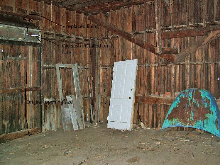  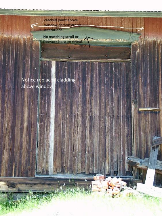 Chris, Except for that maybe the wall has been shorted in hight a bit which would not be a major task given that the the building would be broken down for transport anyway, I am looking at the D&RG freight house door with the window above the canopy. This back door is not even a door although I don't say that it once was in Como. That is not the point. Point is that the original opening of this door opening precedes anything that could have been in Como. So where from? The sash could have been higher previously. Actually under the door frame opening. Note that the window sash is on its side, not vertical , the way it should be. There is not even a door or window frame. Wham, just plonked in there. Is that how a new building is built? There is a brace, as you would do...??? The mock copy of the window head outside does not have the elaborate scroll work that the depot had on its doors and windows. The rear wall, obviously not possible to move in one piece was broken in two. Requiring two braces. Just give me a break here. Just acknowledge something for a change! Just returning to discuss this thanks to your efforts, I think these are walls from the D&RG freight house. I am welded. Weld yourself on the map below. No two buildings where the they used to be, facing the track siding that crossed Wynkoop street.  I hope this helps. I hope you understand that the train orders board was there when the the D&RG station was parallel to the track, south west corner and that it was altered when the station was end on to the track Chris? In case it is not clear print below, "DENVER & RIO GRANDE STATION. 19th & Wynkoop streets 1871-1879." "This wooden depot, longer than it was wide, served the D&RG until the bridge over Cherry Creek washed out and age railroad moved in with the DSP&P. The building was town down by the end of the century." This is on page 11, the last page before moving on to the Union Station. 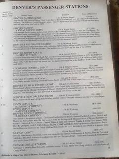
|
Re: Early Wynkoop St. with illustrations and notations. An Error Ocurred.
|
author="John Droste"
Chris, I am really really struggling to follow you just now but I know why. You are putting duty before honour. I am very aware that the building with the red arrow pointed towards it in Denver is not the building that had the train order board. I have never thought that. John: really! You have continually shown the same cropped image and stated you see a TO Board there. Your second paragraph, I can only guess at. I will try to answer guessing at what I think you wanted to say. Jeff, "Map, 1878-79 showing layout Of Kansas/Denver Pacific passenger and freight, Denver & Rio Grande and Colorado Central depots. In 1879 the Denver, South Park & Pacific was also interchanging with the Colorado Central thus the second bridge over cherry creek (Wewatta St), the D&RG being the first being rebuilt after the flood of 1878 (Wynkoop St)."  Just note that the RG "depot" is marked north side of the track and the "freight" South side. John: Wrong conclusion on your part. D&RG Freighthouse not shown on that map. Freighthouse shown is the s.g. DP&KP Rly's. How about you examine more than one map on this; to avoid errors, or intentional omissions by the various Mapmakers. Chris, I have always understood that the D&RG station was located on the far side of 19th street. I think we agree! And the D&RG freight depot directly behind it. Hence the two buildings that you pointed out from the view from behind the KP.  And so the the buildings I marked with crosses are in alignment with the back of the D&RG freight depot.  Line all buildings up with the KP. John: Those scribbled with an X are on 18th St. They would be lost in the smokey distance in that Image. Perhaps I did not explain it as well as I could have previously. The building with the red arrow is here located in the red circle. The important thing to note to stop the confusion about this being the building with the train order board signal is that there is a space between it and the Ben Delaney building on the corner.  I now identify the D&RG freight buildings across the road for the first time, thanks. But we return to this building now, the building that has no gap between it and the tiny Ben Delaney building. The building that I say was the D&RG station previously located south west corner of 19th & Wynkoop streets. Directly across the road from the Ben Delaney building if it were not for the building being actually ON Wynkoop street instead of NEXT to it, as buildings usually are. John: You have overlooked the photographic evidence that there is no gap visible between Ben Delaney's and the TOBoard building; perfectly obvious in the DPL X-23204 I enlarged and notated in my above post. Are you saying they moved that building too? I am not welded onto this, but I ask you to look at the window that you drew in above the D&RG freight room doorway canopy. (Above) And below,  Just give me a break here. Just acknowledge something for a change! John: I did not draw in a window on the D&RG Freighthouse; you are very much mistaken. I only outlined the light/dark areas in the Kansas Pacific Depot image DPL X-25217, of the D&RG Depot and Freighthouse. You seem to be confused here as to just which building is which despite more than a few cross-matching images and maps presented by myself in earlier posts on this page. There appears to be no awnings on the D&RG Freighthouse on Wynkoop. Perhaps you should study the previous posts again. Just returning to discuss this thanks to your efforts, I think these are walls from the D&RG freight house. I am welded. I hope you understand that the train orders board was there when the the D&RG station was parallel to the track, south west corner and that it was altered when the station was end on to the track Chris? John, For the last time: There has never been anything in Print or Image to back up your "end-on" theory. There would be no requirement to have a Train Order Board in a Terminal, what-so-ever! Purpose of said Signal is to advise the Engineer whether he has to stop(or not), for Orders, at Intermediate Stations. Wynkoop St. Depot is the North end of the(D&RG) line. There are no Signals nor Interlocking on the Wynkoop St. trackage of the D&RG: only at the crossing of Wewatta St./19th St. is there any Images of such at the time period circa-1881.
UpSideDownC
in New Zealand |
«
Return to C&Sng Discussion Forum
|
1 view|%1 views
| Free forum by Nabble | Edit this page |

