Pre-C&S Central City map
1234
1234
|
I'm looking for a map of Central City prior to the one drawn by the ICC. What I hope is out there is a map showing the yard limits in the UPD&G or CCRR era--1880s or 1890s. I've been able to create theoretical maps from photos and documentation but trackage details I am trying to verify are missing or are off frame. The ICC is a good start for the general feel but after 1899 the small yard area just beyond the station was heavily modified and enlarged.
The only maps from this era I have seen are the Sanborns (1887, 1890, 1895 and 1900) which show the northwest half of the yard, specifically the business section and spurs from Gregory up Spring St. but these cut off just before the brick section house and omit the small yard entirely. I know the UPD&G mapped Blackhawk in 1898 but haven't seen a similar map for Central City. Does anyone know of, and can share, a map from this era?
Dave Eggleston
Seattle, WA |
|
Dave,
see what you can make of this 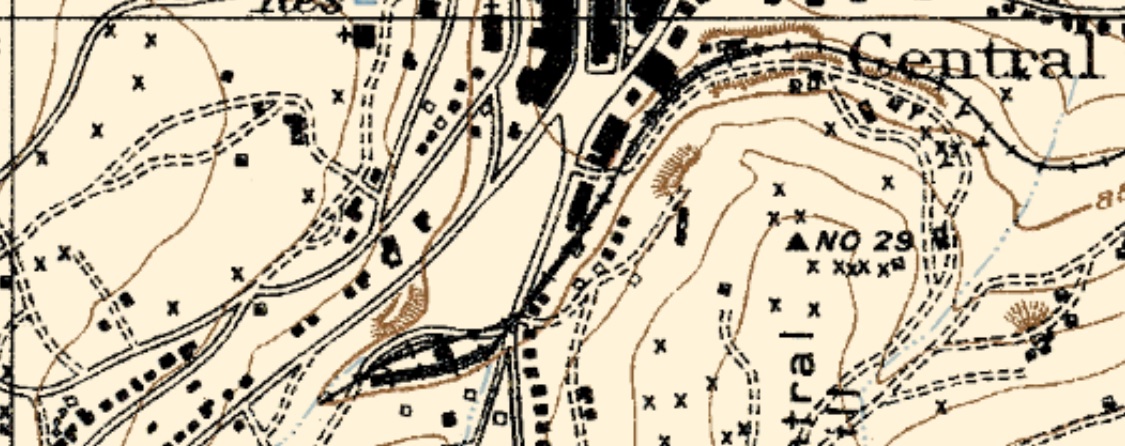 The map is the USGS Central City 1906 special found in the map-pocket Mineral Belt V-III and used in other books on the Gilpin. Doesn't show the Hawley Coal Trestle Siding though. As you mentioned, you can establish the Sidings through photos, Harry Lake's come to mind with the exception of the team tracks at CC where the original Warehouse stood before the new Depot was constructed. There has been several threads covering this area on here in the past.
UpSideDownC
in New Zealand |
|
This shot is from Dan Abbott/Dell McCoy's Gilpin Railroad Era by Sundance pg339, a portion of a Harry Lake photo that didn't show last night when I went through the Lake collection at DPL.
Best I can do under this lighting and printed format. 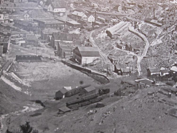
UpSideDownC
in New Zealand |
|
This post was updated on .
Thanks, Chris. Yes, this is a fantastic photo, the only photo of the freight yards likely prior to the C&S that I know of. I have drooled over this photo for years--and have pored over the DPL collections online, hoping to find it, without success.
I believe the caption in the book is incorrect, this isn't 1887 nor 1888, it's mid-1890s prior to 1899. The Hawley and Sauer-McShane warehouses have peaked roofs--they were flat prior to at least 1890 and likely several years later, the D&CC mine is way too big for this period and the billboard for Beeman's Gum, to the best of my findings, wasn't in place prior to 1893 but maybe not put up until the very late 1890s. This last bit *could* date the photo to the first year of C&S ownership prior to the very heavy rebuilding of the yard--but I like to imagine it being late UPD&G. At the minimum it reflects what the UPD&G had there in the final few years. I would love to see an actual print! To me this photo is important as the earliest one I know showing the entire Central City yard limits. It confirms that the yard had already evolved into an arrangement between ca 1885 and ca 1895 that heavily influenced the yard the C&S would build here in 1899. The section house and station are connected and the station has its enclosed porch entry. What appears to be the 2nd freight structure (or maybe 3rd, but that's another topic) is there in all its glory. The stockyards are visible and the foreground shed at the far left end of the yard may be the earliest incarnation of the oil depot. I have no idea what that shed on stilts on the house track just left of the freight house is. It's a weird thing, on stilts above the baseball field, perhaps a warehouse for one of the larger local mining companies. I'd wondered about dynamite, lime, hay and other items but nothing seems right for it.
Dave Eggleston
Seattle, WA |
|
Dave,
I've long given up on the DPL assigned dates, just assemble a collage of like views and work from there. About the C&S rebuilding the yard trackage, where did that come from? I've forgotten. Pity no conclusive UPD&G pictures have surfaced. What's your thoughts on the CC trackage beyond the Depot and runaround siding? Just a couple of end-track sidings at that time, or maybe double-ended as well. Given the traffic levels up there would there be a need (in the early years) for anything other than a couple of spurs? I imagine the turnout to the Coal spur and runaround siding would have been a 3-way at that time. 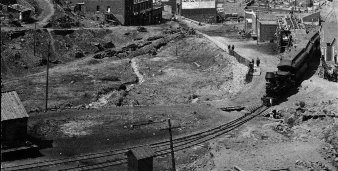
UpSideDownC
in New Zealand |
|
This post was updated on .
Same for me on timing. I looked at as many Central City photos as I could find and started recording unique features--billboards, roof details, etc.--and started to piece a chronology together cross-indexing everything to the Sanborn maps and other details I know for the railroads. It's of course somewhat rough but places things on the timeline. The books and DPL have some interesting captions but fully understandable if you don't look at the non-railroad buildings in town.
The rebuilding of the yard track comes from Dan Edward's Documentation Series, VII, which has a few articles on the rebuilding of the yard area in April, May and June 1899. There is talk of removing the stockyards, moving the oil facility and grading; another article talks of cutting into the hillside to give more space. The size of the new depot would also have required changes. Looking at that photo from Abbott's book and later photos and the ICC map you'll note a couple of things: the "main" at this time is on the near side of the freight shed and the "house" track is on the backside in the photo. After the new yard was put in place, these flipped. It appears the house track in the Abbott photo may not (I am not 100% certain) connect to the tail track in UPD&G days, but later it was. The team track in the Abbott photo, with coal cars sitting on it, certainly would've been a tight squeeze for the teamsters and this roadway was widened by the C&S. One big question I have is if the UPD&G had extended the tail to EOT for a rumored spur for Nevadaville traffic. The trackage on the other side of Spring street evolved slowly over the years but other than the coal bin track every track put in seems to remain to the end in this section of the yards. I now believe what you call the passing track next to Hawley's was used as a double ended siding by the railroad crews, that runarounds happened in the yard area, not here. This track was used by Hawley starting in 1878, and as far as I know was the first and only siding or spur for businesses for the first 10-12 years. Hawley's original 1878 stucture was about 2/3 of the later structure and was primarily storage and stable. The addition, which came around 1879 or 1880, was a hay barn. Hawley's was fed by a chute. Two things I know of Hawley's in the early years is 1) the warehouse could hold 10 carloads of freight and 2) one month very early on in the first or second year they expected 30 cars of freight in a single month. Between 1890 and 1895 Zang's built a warehouse next to Hawley's and used the same siding. There is one photo of Zang's that shows what may be a chute. The coal bin spur seen in the ca 1884-1886 photo may have fed off a 3-way turnout next to the section house or a pair of normal turnouts at that location--I have no info on this as it's covered by the train in that photo. The one broadside photo I have of this area that shows anything is from after it was removed (ca 1887?) and one leg of the trestle remains by the section house. Heading further towards Black Hawk was the Sauer-McShane warehouse spur, put in around 1891-1895. Single-ended and lower than the mainline grade. This warehouse was also fed by chute, perhaps two at the height of business. This spur also appears to have been used for the Denver & Central City mine by 1900, using chutes to feed its coal, and possibly, ore, bins. Around 1905 a final spur, single-ended, was added just before the Sauer-McShane/mine spur, that was used to feed the lumber yard far below on Gregory via a long chute. Between the section house and Hawleys was a beer warehouse (Neef's?) and big coal shed, both showing up around 1905. They were both fed by the double-ended Hawley siding. I also know that the little brick station was not the first Central City station. There was one before it from May 1878 - January 1880. Rather than build a station, they remodeled an unused mill, the Montana, just as they had done at Black Hawk. It sat where the yards were, and I think that horizontal track in the foreground of the photo, of the train coming into the yards with the coal bin, was a remnant of the mill's interior workings. The CCRR used it as a passenger and freight station and also had space to store the engines inside. It was burned down by an arsonist. Porter #6 was damaged in the fire. It was towed to Golden and rebuilt. Something like 6 months later it was switching in Golden and went into the creek when the bridge it was crossing collapsed. Hoodoo engine?
Dave Eggleston
Seattle, WA |
|
This post was updated on .
In reply to this post by Chris Walker
I didn't comment on the USGS map, sorry.
The arrangement mimics that seen on the later ICC map, minus the siding for the lumber yard placed just prior to the D&CC mine. So what I'm seeing looks pretty much otherwise as expected. I'd also wondered about the Hawley double-ended siding on this map but am not convinced it's not there but could be an issue in the printing that ended up merging the two tracks into a wider line. Or it was left off, as I've seen happen on other USGS maps. I've been searching the forum over the years scouring for clues on the early period but there's not much out there. If you know of a thread I've missed, let me know.
Dave Eggleston
Seattle, WA |
|
This post was updated on .
Dave,
I hunted down the USGS Topo of Central City 1906 Special. The USGS has these separately from the actual document of professional papers. Here's the extreme enlargement..... 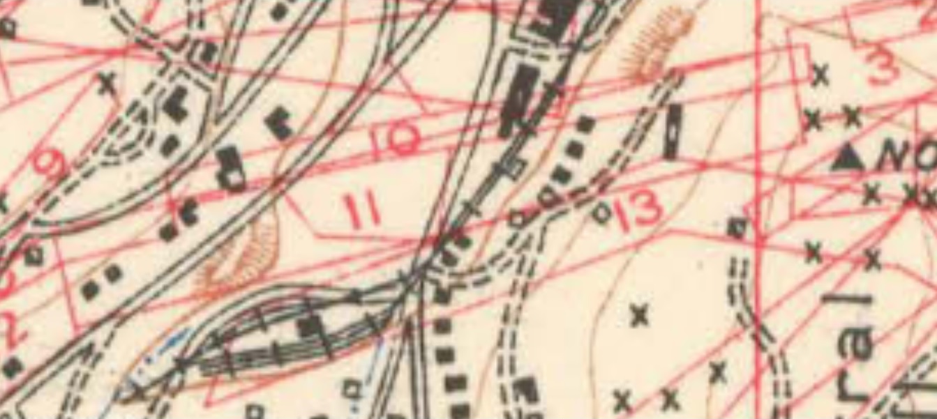 The symbol for a turnout is an elongated triangle, wide crossbars for multiple tracks. and my interpretation of the trackage shown thereon. Whether the Siding is connected at the ?-arrowed spot is debatable. There appears to me to be a turnout symbol there, and certainly 3 Teamtracks. Whatever that minor arrangement was, it sure was a tight little "modellers dream" Yard. 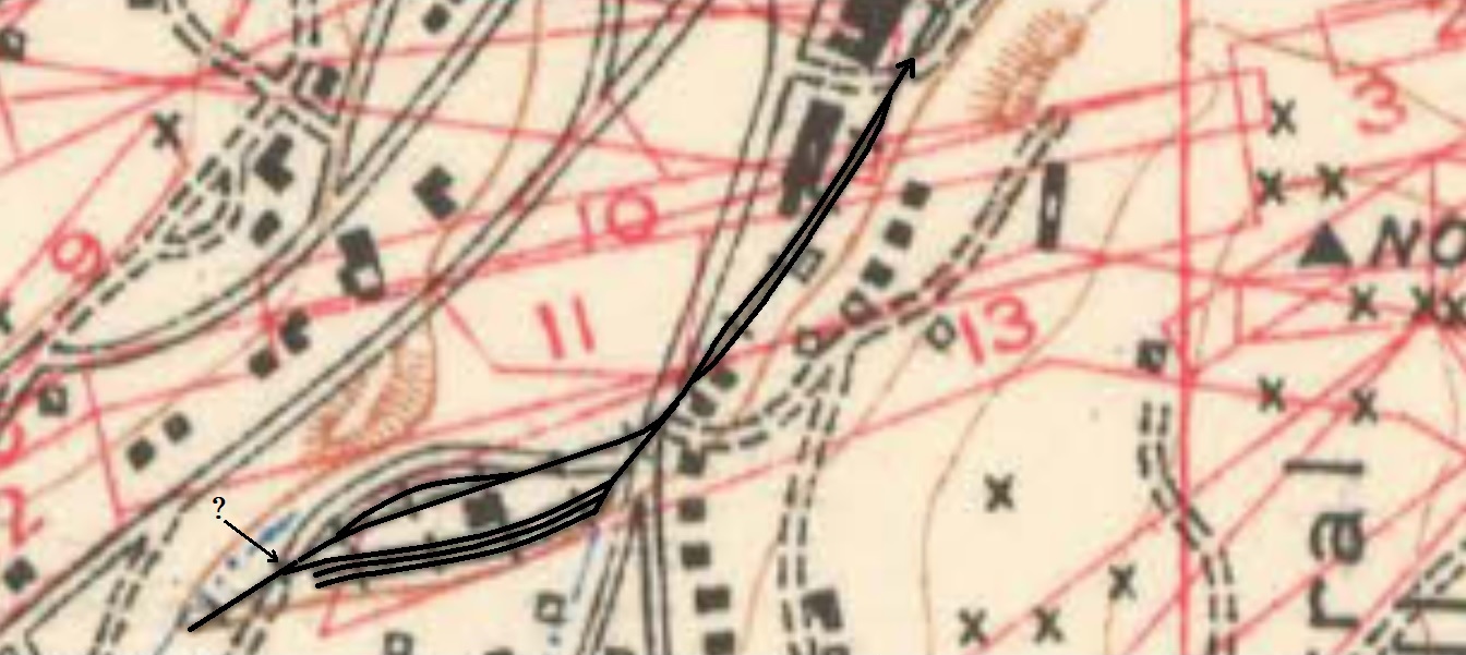
UpSideDownC
in New Zealand |
|
This post was updated on .
What you've drawn agrees with what I saw in the original image. I'm always somewhat leery of USGS topo maps as the final word on specific track details, having seen errors in the past, but that doesn't mean I'm arguing this map is wrong, just that it's one data point and we've got nothing else to say it's absolutely correct.
I did find some images of the 1906 special map on ebay which show the Black Hawk area trackage being pretty consistent with the trackage shown on Sanborn maps, on an 1898 map of Black Hawk and on the 1918 ICC map, and all this for me strengthens the case for the Central City trackage arrangement as shown on the 1906 special map. What concerned me first on the map is the three-track team area. If you connect the middle team track to the track adjacent to the station, making the connection just to the left of the station, you now have the passing siding that held the cinder pit, shown on the 1918 ICC map. Could this middle track have been a spur originally? Could this have been erroneously drawn as a spur? I dunno...some thoughts to keep in the back of my head. At this point in time coal was delivered primarily in this team area, there wasn't a dedicated coal shed, so two tracks may have made sense. But how to get cars unloaded from that middle track to a wagon when all three tracks are occupied? You'd have to unload through cars at times. We also have to consider the issue of needing a runaround at the station. The new station was built for the main to be on the Central City side of the building and the house track on the opposite side. If the other two tracks are spurs there is no allowance for a runaround. This for me argues further that the center of the three tracks was likely connected left of the station to allow an engine to bypass the house track and get around its train. There could be an argument that the Hawley track was used for this, but when occupied it would've been a headache for the crews. Again, the map may be 100% accurate, but it's odd enough in design--they reworked things to make them more functional, not less--that I have to wonder about what we're seeing. Lastly there's that odd, short double-ended siding on the other side of the depot of maybe 100' to 150' length at best. This doesn't show on the 1918 ICC map, so what was it? One theory could be that it's the original location of the scale track, which later was moved to the right of the depot? Or could it have been a holding track for the engine during the time when it overnighted in Central? But why would they need a special track for that? Some really great questions are raised by this map. As you say, Central City is a modeler's dream. This bit of the yard will easily fit into an 8' linear space in HOn3; the overall yard limit at its fullest extent back to the first switch can fit in about 18' in HOn3. A lot of action in a very small space.
Dave Eggleston
Seattle, WA |
|
This post was updated on .
Well, you two have finally drawn me into the conversation.
I tried to scan the Lake photo in the Abbott/McCoy book to see if I could play with it and see more. Alas, this isn't much better: 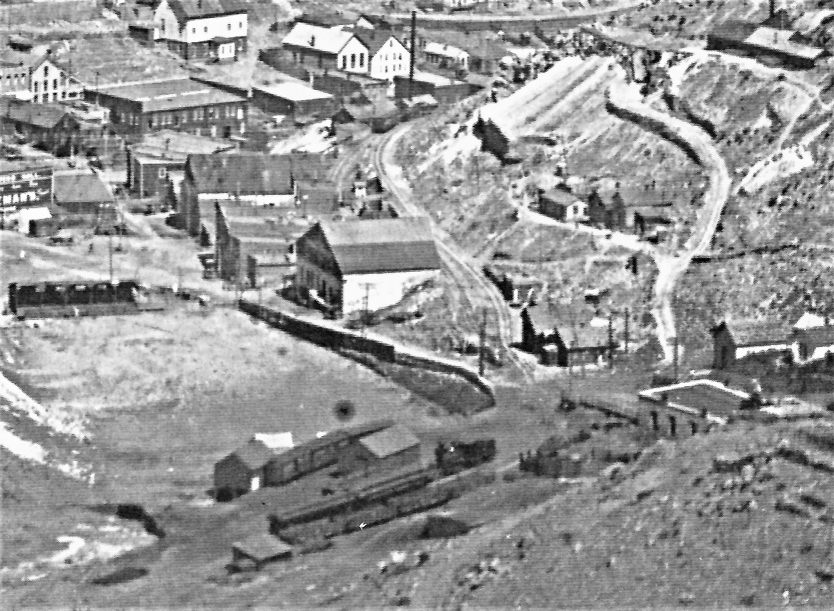 This is what I see: The locomotive is spotted on a track that runs adjacent to the freight house. The passenger cars are spotted on the middle track in Chris's map/drawing. Was the ash pit to the right of the two cars? The coal cars are on the third track, closest to the hillside and stock pens. The "freight shed" has large doors on this side and the left end, with a platform on this side and end as well. The boxcars are spotted on the curving siding in the distance. The only other photo that includes the freight house is a DPL photo that Chris posted on the Central Depot thread: 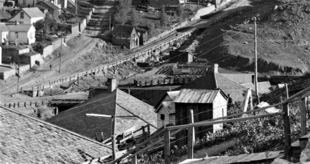 The back spur has the coal cars as above. The roof of the freight shed is visible. The string of boxcars in the foreground seem a bit distant from the freight shed, consistent with the first photo. IMHO, the middle of the three tracks is likely the one connected to the track on the town side of the freight house. In daily operation, it would not be occupied, unless the passenger or a freight were in town. That would allow cars to be spotted on the spur next to the freight house for unloading--none happen to be there on the day of Lake's photo. Teams could access spotted cars on the freight house spur or the "coal car" spur, by driving up on top of the through track--if a train arrived they would have to move. On the far side of the freight house, the closest track would also be a through track, for runaround moves. Teamsters could access the freight house and the boxcars spotted on the short siding, by again driving upon the through track as long as no train was present. My interpretation of the Lake photo is that the late afternoon passenger has arrived, stopped at the brick depot and unloaded passengers. The locomotive has then pulled the two empty passenger cars down the middle track and then cut them off, proceeded left to the switch that formed the runaround, backed down the track behind the freight house to the yard throat, then pulled forward onto the freight house spur, spotted for the night. In other words, the pre-C&S track arrangement was the same as the post-C&S arrangement, with the exception of the short, 4-5 car siding that's about to fall into the outfield of the ball park (maybe that is what happened to it!) Just my two pesos worth . . .
Jim Courtney
Poulsbo, WA |
|
This post was updated on .
Welcome, Jim. From the first time I saw the Lake photo that's what I saw also. This photo does pre-date the 1906 map by 5-10 years and we know that this portion of the trackage was reworked in some way, the area widened and the bigger station put in after it was taken.
The ash pit, in the C&S years, was just to the right of those cars, or just under the right end of the rightmost car. I agree that the pre-C&S arrangement informed the post-1899 C&S rebuilding of the yards. For the space and traffic levels this arrangement is a brilliant adaptation, what the Brits call a "loop and two sidings." The Lake photo represents the evolutionary height of that earlier arrangement--the next earlier photo we have is the one of the train coming into the yard with the still-standing coal bin is circa 1885 and the yard is far simpler. What the C&S decided on was a larger station/freight structure and more space to move traffic in and out of cars, so the hillside was cut into. But there was little space to vastly expand given topography and the baseball field. You raise the question of two tracks on the Central City side of the freight house in the Lake photo. I've always believed there was only one, and a wide platform, with that side being a single house track. But there could be space for two, however the only access to the cars on that outer track is by parking wagons on the track adjacent to the freight house. The other side was a steep dropoff into the outfield of the baseball area. The 1906 map was originally surveyed in 1904 per the captions on it. Just adding that in to fill out the chronology. I do know of at least one other non-map reference, a track listing for Central City from November 1900, also found in Edward's Volume VII, page 208. On this list are the tracks numbered starting with the track switch closest to Black Hawk (Sauer McShane) and increased to the end of track in the yard: #1 Mill (I believe this is the Central City/Sauer-McShane shared spur--I am not certain why it is listed as "Mill" as I don't know of such a thing there...perhaps Sauer-McShane milled grain or they are referring to the lumber mill down the hill that was fed by a chute) #2 Warehouse (I believe this is Hawley/Zangs shared double-ended siding) #3 House track (I believe this is the track on the backside--opposite the Central City side--of the station) #4 Cinder Pit (I believe this is the middle "team track" which was a double-ended siding) #5 Wagon (I believe this is the team track) The mainline track in the yard is not numbered, of course. No other tracks are listed in 11/1900 since the final spur just beyond the Central City mine was not yet built. This list corresponds almost exactly to the 1918 ICC map and I think works when back-engineering it to the Lake photo, except I believe the house and main are flipped in that earlier timeframe. I have a very slight suspicion that in Lake photo that the house track may not connect to the main due to space issues. This November 1900 track list, for me, further puts into question the1904/1906 Special map's interpretation of the team area by calling out the cinder pit track and not two team tracks. It may also argue against Jim's two tracks on the Central City side of the station, unless the mainline is on the opposite side of the station an un-numbered. Hopefully all this makes sense. I'm still not going to say the map isn't correct, maybe things did change to its shown configuration by 1904, it just doesn't seem the wisest arrangement for operation. And lastly, that short runaround in front of the station could represent the original location of the scales before they moved closer to Spring street.
Dave Eggleston
Seattle, WA |
|
Jim, I am late to the party an admittedly not a Clear Creek expert. In the image from the Abbott book, isn't the ball field there already, with the tracks curving around the outfield wall?
I confess that I considered Central as my modeling subject for a bit. I like the compact yard, and the brick Italianate depot is a plus. Aside from Harry Brunk (?), I don't know of any models. You are all making the yard even more interesting with the additional switch. Seems like the track with the passenger train is the arrival/departure track. The various tracks around the depot have very particular functions and the siding east across the road is a handy runaround. The whole works is just screaming to be modeled and can easily fit on a shelf or peninsula.
Keith Hayes
Leadville in Sn3 |
|
This post was updated on .
Yes, Keith, the ball field was there. It showed up in the late-mid-80s.
I'm not aware Harry modeled Central City at all. Did he make a model of the station? Yes on the tracks and specificity. They had almost no space and the yard definitely grew out of need and experience. The C&S station and yard reconstruction expansion reflect an optimism that seems well placed in 1898. Fewer tracks actually make it the most interesting to me, keep it to the two business spurs (feeding 4 businesses) outside the yard proper, a house and team track in the yard proper. Runaround track and you've got the fixings for a really interesting operational layout. Change the date and add the coal bin or coal shed and Neef's beer and you've got even move in the same space. I think it's one of the most interesting compact prototypes for narrow gauge out there. I've been planning a layout of this in HOn3 and with a staging area just around the corner could fit in under 24'. Have started building structures or have materials on hand. It would be a really great 1-2 operator layout. The near-level mainline running behind Sauer-McShane through the Hawley track into the yard would contrast wonderfully with Spring Street climbing steeply up to the crossing of the railroad, with the various warehouses and brick buildings on the slope, mostly lower than the railroad. I really hope I can find the space to do this!
Dave Eggleston
Seattle, WA |
|
This post was updated on .
This is how I have always guessed trackage in the Lake photo which I date to after 1895 (Hawley's and Sauer-McShane have peaked roofs after 1894) and before the C&S rebuild in 1899.
Red is the main, yellow is sidings. Dashed yellow line is where I'm not sure if there is a connection at that end of the house track to the main. I've indicated where the original coal bin was (1879-ca 1887), the coal shed (after 1905) and Neef's (after ca 1905). This area appears from photos to have been mostly empty from ca 1887 to ca 1905, except for some lumber loads at times. Jim, if I understand, you put in another track between what I've called the house track and the freight warehouse. 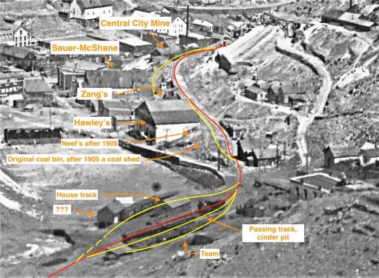
Dave Eggleston
Seattle, WA |
|
This post was updated on .
Dave,
Your map is one reasonable interpretation. The only issue I see is the long platform and freight door along your "mainline" at the freight house. Doesn't make since to me. Unless I misunderstand, before the C&S brick depot was built, the only structure here was a "freight" house. The structure has no man doors or windows to suggest that passenger trains used the platform. Passengers would not have boarded trains here, rather at the brick depot and section house area. Blackhawk bound trains would have boarded/loaded on the right side of the road(s) crossing. Arriving trains likely would have unloaded on the left side of the road crossing. Plenty of space for carriages and wagons to meet the trains. I think your red line by the freight structure was a freight house loading spur (possibly a siding, if joined again to the left of the big structure). So I think the though track is the same as in the C&S years, the middle track with the coaches on it. As to the two tracks on the City side of the structure, I didn't put them there, Chris did, with his topo map interpretation: 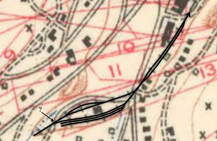 Bars crossing tracks, by convention indicates multiple tracks. The map suggests a teamsters road between the short track where the boxcars are spotted and the ball field. If the middle track on the uphill side was the only through track on that side of the freight house, the straight track on Chris's map, between the structure and the "boxcar" track would have been necessary as a runaround. Granted, I don't know how much faith to put in this single document (we've all seen even "official" C&S documents, that have survived, that really bore no semblance to reality). But the topo map is the only document that we have. I would suggest that the throat of the three tracks near the street intersection was a three-way stub, as in later years: 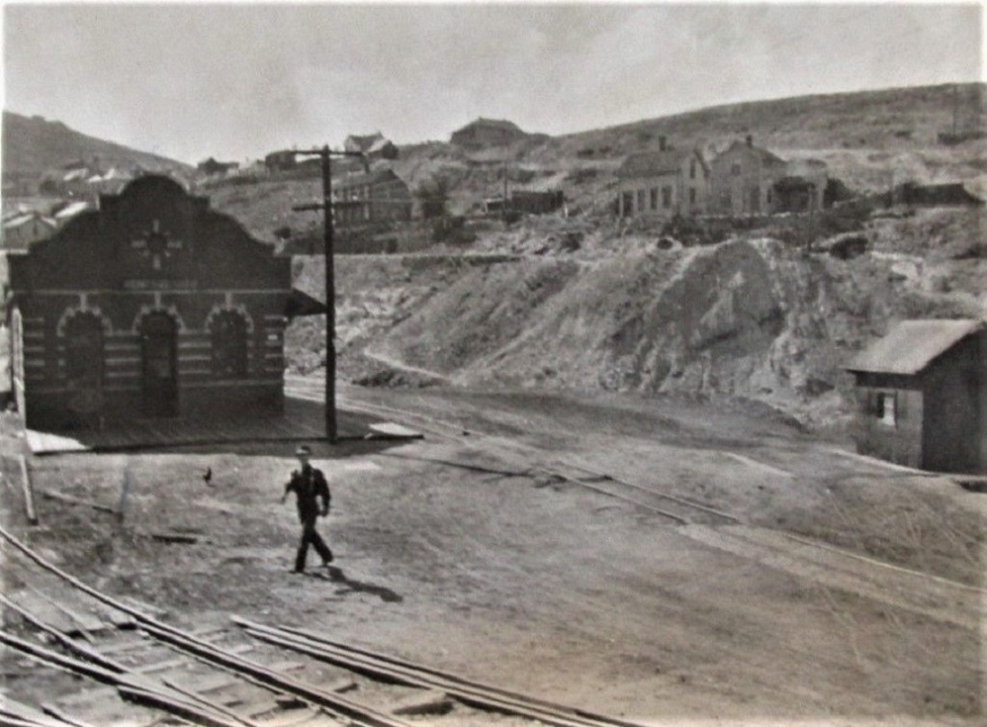 Note that the scale house to right is for wagons, not freight cars. Also note that the ties and rail aren't really an impediment to teamster's wagons--the ground was pretty much level with the top of the rail with fill dirt and gravel, with wood crossings at the points of most frequent use. So wagons could have accessed the two outside tracks in the three track area, by simply driving between them, where the though track ran (as long as the trains were out of town). That might suggest the cinder pit was originally on the right end of the freight house spur, where the locomotive was spotted in the Lake photo. I'm not being facetious to suggest that the short "boxcar" siding may have fallen into the ball park outfield. The slope from the depot area down to the ballpark was very steep and constantly eroding. Several photos in the 1902-1918 period show that the railroad was constantly hauling in fill to shore up that slope. I believe that it was a flood coming down the gulch to the left, that ultimately took out the ball park and bleachers. And yes, Central is a perfect theme to model. It is my back up plan for Sn3 C&S, if I ever lose my current space and end up with just a spare bedroom. This is what I'd model in that eventuality: 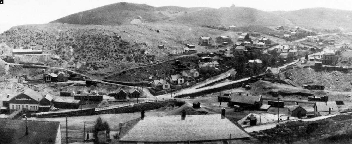 A small layout good for 1902, 1909 or 1920. Plenty of opportunity for compression of background structures for perspective, ala' Keith's Leadville residential area. I would probably need help with that brick depot, though, Keith 
Jim Courtney
Poulsbo, WA |
|
This post was updated on .
Also include 1887 or 1895 as really interesting periods for a model. For me the early 1890s is the sweet spot for modeling, when the roofs on the two warehouses were still flat, there was a lot of variety in cars and road markings and the yard space was slightly smaller. I'm even considering moving it back to 1887 so that I can have the coal bin siding. And building those big stone and brick warehouses will provide some big challenges.
My original thinking for the house track on the opposite side of the freight house is based on that line of boxcars unloading there in the Lake photo. Or are they simply parked while the engine breaks up the train to switch? Lots of room for interpretation and what I drew was just one possibility in this pre-C&S period. It would be phenomenal to have a photo looking at the other two sides of the freight shed. The mainline track always extended into the yard area to the EOT past the freight shed, even in the era when the passengers detrained at the small brick depot, as was the case in the Lake photo. The spurs and sidings fed off it, even in the freight yard. I don't think that I implied passengers detrained at that freight shed. The Lake photo and the 1906 map represent two different phases in the life of the yard. The C&S dug out the hillside to expand the width in 1899, and moved or expanded trackage somewhat, so that road next to the ball field seen on the 1906 map may not have been possible earlier in the yard's life. I also believe the switch to those three tracks was a three-way, even in the Lake photo.
Dave Eggleston
Seattle, WA |
|
Charles Dollins has some 3D stl files for The Central City depot.
I haven't printed them but his pics look good http://charles.dollins.org/buildings/index.html Ken Martin 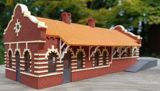 |
|
This is intriguing, Ken.
It appears that the gentleman will sell the stl files for the Central Depot for $4.00. So what then? Does one then need to buy a Prusa printer and PLA plastic filament and then print your own parts to assemble? Can one purchase the files and have an outside firm do the printing for you? Are the pieces printed in different colored plastic, like an injection molded structure? How does the PLA plastic take paint and weathering? Following the link, there are some other C&S related structures like the Forks Creek structures and some Blackhawk stores . . .
Jim Courtney
Poulsbo, WA |
|
Jim,
Once you have the stl files you can print them yourself or have someone else print them. The printed color depends on the filament color used. I know a man who uses PLA printed items in his garden railroad. Also after you paint them that blocks uv rays so no deterioration. As others can attest 3D printing is a whole nother world of modeling. Ken Martin |
|
The one question I'd add in is around the scale of the initial drawing. If designed for a large scale output there can be issues printing in smaller scale, from what I'm hearing on 3D printing groups. Not just the object's details but also the supporting structure added for the print process. I've not done any 3D printing but just tossing that out there.
Dave Eggleston
Seattle, WA |
«
Return to C&Sng Discussion Forum
|
1 view|%1 views
| Free forum by Nabble | Edit this page |

