D&RG Grading Through Platte Canyon...

Previous Topic Next Topic
 
classic Classic list List threaded Threaded
38 messages Options
12
Reply | Threaded
Open this post in threaded view
|

D&RG Grading Through Platte Canyon...

chtrout
This post was updated on .
I have been conducting very detailed research regarding the D&RG "South Platte Extension" (aka Acequia Cut-Off") for which the Location Survey was completed on 1 May 1879 as far as Deckers, with at least preliminary grading starting almost immediately from "Platte Junction" (D&RG m.p. 13.7, now Wolhurst, just north of Acequia), and then all grading being discontinued in January 1882 approximately 4.7 miles short of Deckers, the latter being the end of the completed 1879 Location Survey.  The actual grading base camp was located at Acequia (D&RG m.p. 17.5), which for this reason, is sometimes confused as the starting point for the extension.

As I'm sure many fellow members are aware, the C&S later used brief segments of the dormant D&RG grade, first near Vincent (C&S m.p. 21.3 opposite Waterton) on the initial C&S approach to Little Willow Creek and what would become the 3.89-mile C&S "Silica Branch" (1909-1941).  They also used a segment of the dormant D&RG grade between South Platte and Nighthawk to become the 4.12-mile "Nighthawk Branch," which was proposed in 1899 and actually built in 1902, with service being discontinued in 1916.

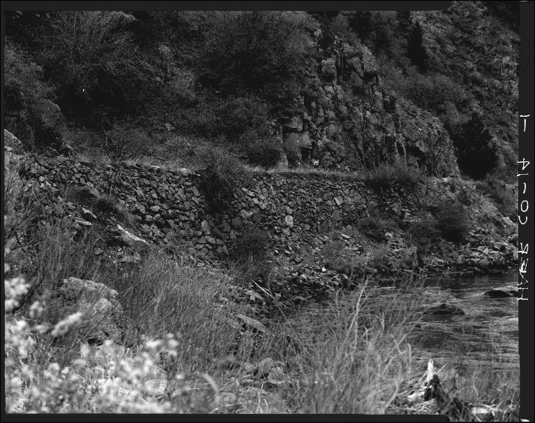
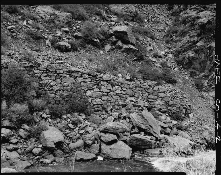
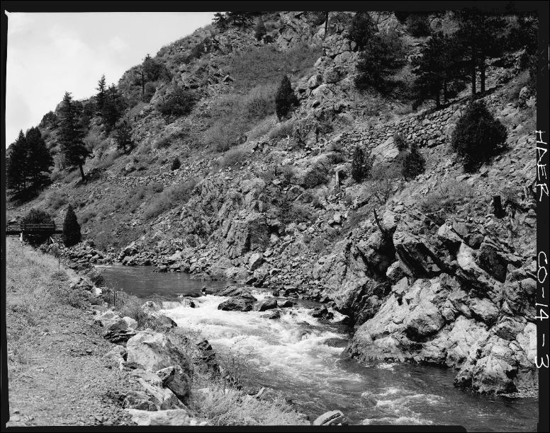
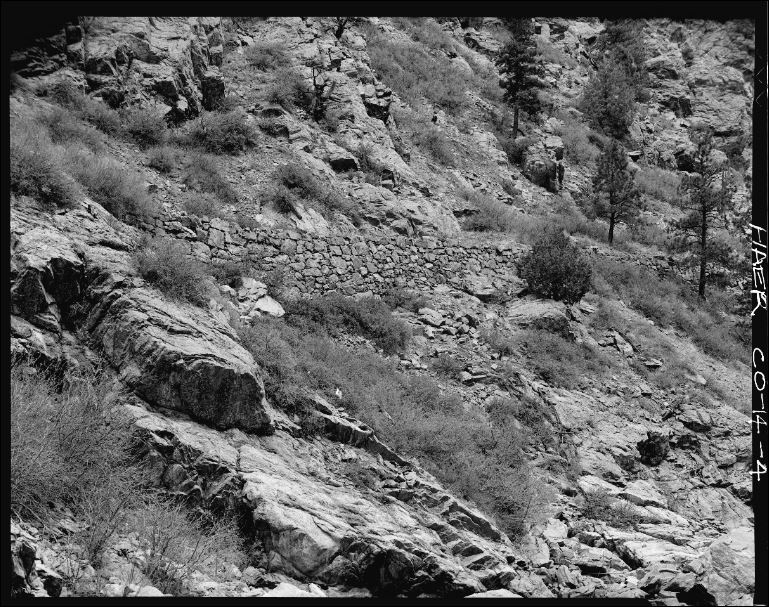
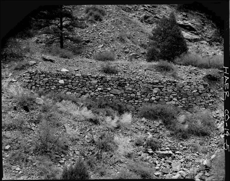
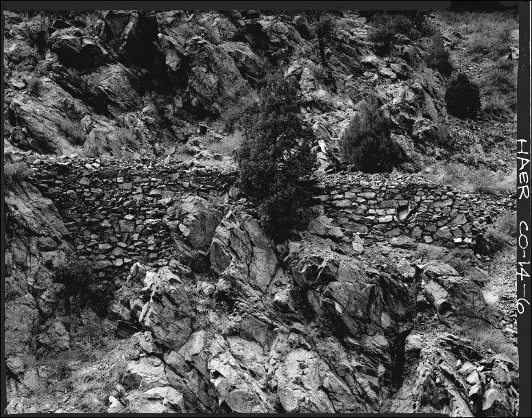
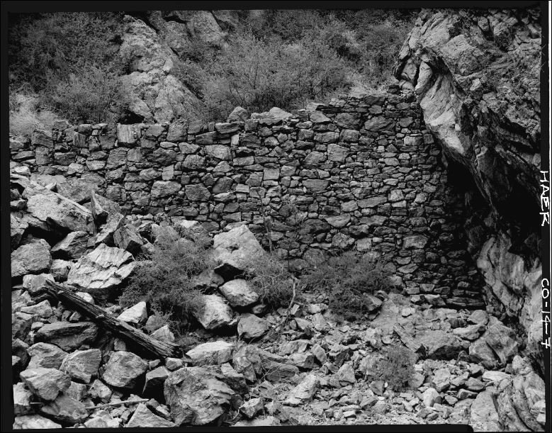
In very general terms, the D&RG grading, after leaving "Platte Junction," dropped down to a sweeping curve and bridge over West Plum Creek (belowAcequia), again climbed back out of the West Plum Creek drainage, then generally following the terrain contours to make a relatively high-level entry into Platte Canyon just opposite of the Platte Canyon (Waterton) wye.  Nearly complete grading continued on throughout most of the canyon, first exchanging sides of the canyon with the DSP&P via a proposed high bridge near Mill Gulch (DSP&P "lower iron bridge") to the north side of the canyon, then once again exchanging sides of the canyon with the DSP&P in the rocky narrows just above Deansbury and the "upper iron bridge" via a proposed high bridge and tunnel and then continuing on the south side of the canyon until eventually returning to a near-river-level grade approximately 1.5 miles east of South Platte.  The only major gaps in the nearly-complete grading occurred first at the rocky ridgeline which would have required either a tunnel or deep rock cut high up on the ridgeline from the Highline Canal tunnel below, and the second significant gap occurred just above Deansbury where very expensive tunneling and bridgework would be required.  Most other segments of the grading were fully completed, or nearly so, and some even required significant rock retaining walls.

>> My question is this…  Has anyone been able to locate the original D&RG survey completed in May of 1879, or of the renewed survey activity from 1889, still based on the original 1879 survey?  Does anyone have any DSP&P right-of-way maps, C&S blueprints, or trackage diagrams that also show the D&RG grade or related construction data?   On a side note, the DSP&P had already been operating through the canyon for a full year before D&RG grading actually began.

(The ICC maps do show where the D&RG "Acequia Cut-Off" left the D&RG mainline nearly midway on what is now the Wolhurst sliding, as well as the very short segment of D&RG grade just west of Vincent, nearly opposite Waterton.    
Craig H. Trout
Reply | Threaded
Open this post in threaded view
|

Re: D&RG Grading Through Platte Canyon...

Chris Walker
Craig,

I haven't found the east end Map like I said in an older thread..... but how about some pictures, eh!

HAER CO-14
ca. 1875 Initial Construction


https://www.loc.gov/item/co0042/
UpSideDownC
in New Zealand
Reply | Threaded
Open this post in threaded view
|

Re: D&RG Grading Through Platte Canyon...

chtrout
This post was updated on .
Hi Chris,

Wow!  I had recalled that HAER had very good coverage of incomplete D&RG grading segments in Platte Canyon, but I had forgotten there were actually at least (7) images in the series – I think I may have actually missed one or two.  

Obviously, the HAER file label (1875) is incorrect since D&RG grading did not even begin until shortly after 1 May 1879 when the final Location Survey was staked and completed.  Initially, relatively-small crews were grading the first 5-mile segment from "Platte Junction" (D&RG m.p. 13.7, now "Wolhurst") to just opposite the Platte Canyon (Waterton) wye at the mouth of the canyon, and most heavy work within the canyon itself did not occur until 1880-1881.  As with most D&RG grading projects, multiple contracts were let simultaneously, with various segments all under construction by different contractors all at the same time. Interestingly, some of the very same contractors, to include Isaac W. Chatfield, who had just finished the DSP&P construction through the canyon, now received contracts for the D&RG grading, and in some cases, even used their same original grading camps, such as Chatfield had set up on the gentle slope directly across the river from Deansbury.  As a point of clarification, it was frequently called the "Acequia Cut-Off," since the station at Acequia [D&RG m.p. 17.5] was the nearest settlement to Platte Junction, and Acequia was also the main grading and supplies base camp for the entire project.

Considering how relatively complete the various rock walls are and such in the HAER photos, I would estimate that they date from the 1881 construction season, recalling that construction was discontinued on 30 January 1882.  

While I do know that the project was totally resurrected in 1889, this time envisioned as a standard-gauge "Denver Shortline" to "Lidderdale" (downriver from "Lake George"), I have not been able to confirm if any "new" work was actually done on the ground.  Obviously, to "standard-gauge" the line would have required reductions in curvature, widening the grade, and such, but I have not seen any evidence of that actually occurring.  Regardless, the 1889 Location Survey reportedly was based on the original May 1879 Location Survey, with the exception of changing the original destination of Buena Vista via the Salt Works and Trout Creek Pass, to now connecting with the Colorado Midland at Lidderdale instead.  Interestingly, "Denver Shortline" construction was described as a partnership with the Colorado Midland and also envisioned allowing trackage rights for the Rock Island.  Of course, this entire scheme totally collapsed during the rapidly developing period of extreme financial stress, partially caused by the "Sherman Silver Purchase Act" (1890).

Thank you, Chris, for sharing these wonderful HAER photos, they are extremely helpful.
Craig H. Trout
Reply | Threaded
Open this post in threaded view
|

Re: D&RG Grading Through Platte Canyon...

Robert McFarland
Plenty of photos of C&S bridges in Platte Canyon  including diagrams of the one that I think is now in  the park in Bailey
Reply | Threaded
Open this post in threaded view
|

Re: D&RG Grading Through Platte Canyon...

Robert McFarland
In reply to this post by chtrout
Wouldn't the Salt Works be a little out of the way?
Reply | Threaded
Open this post in threaded view
|

Re: D&RG Grading Through Platte Canyon...

chtrout
This post was updated on .
Robert McFarland wrote
Wouldn't the Salt Works be a little out of the way?
Hi Robert,

Numerous newspaper accounts during the initial 1879-1882 construction phase frequently include the projected route as being towards the old "Salt Works" in South Park (near the DSP&P station at "Platte River"), thence down Trout Creek Pass to Buena Vista.  

While it is not mentioned by name, I assume the "approach" to South Park would have been via 11-Mile Canyon, as the proposed D&RG extension continued to follow a water-level route along the South Fork of the South Platte all the way from South Platte, Nighthawk, and Deckers and on into the southwest end of South Park.  

Said another way, the proposed D&RG "South Platte Extension" (aka "Acequia Cut-Off") would first parallel the existing DSP&P through Platte Canyon, then once again from "Salt Works" down Trout Creek Pass on into Buena Vista, much like the C&S later roughly-paralleled the existing D&RG "Blue River Branch" over Fremont Pass and on into the Dickey and Dillon area.

Craig H. Trout
Reply | Threaded
Open this post in threaded view
|

Re: D&RG Grading Through Platte Canyon...

Jeff Young
Yeah, if they were headed for Trout Creek Canon via Trout Creek Pass then the salt works would have been more or less on the way.

A lot of people at the time seemed to expect lots of traffic out of the salt works -- but it never worked out that way.
Reply | Threaded
Open this post in threaded view
|

Re: D&RG Grading Through Platte Canyon...

South Park
  Even in the rough and tumble mining region, Victorian mores prevailed.

  Things were just too salty there.

  Thanks, thanks, ...  I'll be here all week.
"Duty above all else except Honor"
Reply | Threaded
Open this post in threaded view
|

Re: D&RG Grading Through Platte Canyon...

chtrout
In reply to this post by Jeff Young
Jeff Young wrote
Yeah, if they were headed for Trout Creek Canon via Trout Creek Pass then the salt works would have been more or less on the way.

A lot of people at the time seemed to expect lots of traffic out of the salt works -- but it never worked out that way.
I don't think the "Salt Works" area was ever envisioned as a source of D&RG freight revenue, but rather as a well-established familiar landmark since the 1860s. Nearby DSP&P "Platte River Station" had been a major freighting load-out (inbound supplies for, and outbound silver bullion and such from the Leadville District, but then dwindled down to disuse after completion of the DSP&P line down Trout Creek, and a period of very brief "joint operations" with the D&RG into Leadville.


Craig H. Trout
Reply | Threaded
Open this post in threaded view
|

Re: D&RG Grading Through Platte Canyon...

Robert McFarland
Weston was the major shipping and receiving point for Leadville ,not Platte River.You are thinking about Platte Station-a stop on the way between Weston and Weston Pass that some people confuse with Weston.
Reply | Threaded
Open this post in threaded view
|

Re: D&RG Grading Through Platte Canyon...

Robert McFarland
There was quit a bit of activity around Platte River too-particularly a saw mill.
Reply | Threaded
Open this post in threaded view
|

Re: D&RG Grading Through Platte Canyon...

chtrout
In reply to this post by Robert McFarland
Robert McFarland wrote
Weston was the major shipping and receiving point for Leadville ,not Platte River.You are thinking about Platte Station-a stop on the way between Weston and Weston Pass that some people confuse with Weston.
Hi Robert,

Perhaps you are exactly right...  I was thinking that DSP&P "Platte River Station," m.p. 113.5 was one of the same as "Platte Station," but your explanation makes perfect sense, in that Weston Pass was a major early freighting route into the Leadville District.  Regardless, I do not believe the D&RG ever considered the Salt Works area as a potential source for any significant revenue, beyond perhaps some lumber products, timothy hay, and such -- it was simply a well-known landmark for reference purposes.


Craig H. Trout
Reply | Threaded
Open this post in threaded view
|

Re: D&RG Grading Through Platte Canyon...

Jimmy Blouch
In reply to this post by chtrout
More than one route was surveyed for the Denver Short Line.
I have documentation showing the various routes.
However, it is presently not at hand.
When I find it I will try to post the various routes that had been surveyed.

Jimmy
Reply | Threaded
Open this post in threaded view
|

Re: D&RG Grading Through Platte Canyon...

chtrout
Jimmy Blouch wrote
More than one route was surveyed for the Denver Short Line.
I have documentation showing the various routes.
However, it is presently not at hand.
When I find it I will try to post the various routes that had been surveyed.

Jimmy
Hi Jimmy,

Yes, the 1889 "Denver Shortline" was based on the original 1879 survey, which actually considered several possible routes on the west end.  I have highlighted the original route via the Salt Works and Trout Creek Pass that seems to have been reported most often in the newspapers, and the route apparently most-favored by the D&RG.  The D&RG had also considered taking off northwest from the vicinity of the Salt Works, and instead, heading over Hoosier Pass to Breckenridge to connect with the "Blue River Branch," which was already being planned.  A third route being considered took off from Lidderdale (just downriver from Lake George), and then headed southwest over the Calumet Divide and down to Brown's Canyon, although due to the very "rude" grades involved, I cannot imagine this third choice being very attractive.  The very steep Calumet Branch was eventually built on the final segment of this third route.  

Regardless, by the time of the 1889 "Denver Shortline," D&RG president David H. Moffat directly stated that he intended to connect with the Colorado Midland at Lidderdale, or that is to say a near-water-level route along the South Fork of the South Platte for the entire distance, so any alternate routes had apparently been discarded. Also, the "Denver Shortline" had now evolved into a partnership with the Colorado Midland for construction purposes.

A previous post by Chris Walker on 28 Feb 2017 in the "Hello Folks" thread showed west-end of the 1879 survey and selected segments of several of those various alternate routes being considered.   The "Platte Canyon" end of the survey, which all the routes shared as their common origin, seems to be missing unless someone has finally found it.

 
Craig H. Trout
Reply | Threaded
Open this post in threaded view
|

Re: D&RG Grading Through Platte Canyon...

ComoDepot
The arrival of the Railroad in Colorado took a lot of business away from the Salt Works and it does not seem they were active by 1879, there was an attempt to resurrect them in the early 1880's but that failed.

Weston was only there for one winter 1879/80.

Salt Works had a Hotel and sounds more a road junction at the time.

Going over Hoosier into the Blue River is certainly not an obvious route and would have been a major engineering challenge.
Reply | Threaded
Open this post in threaded view
|

Re: D&RG Grading Through Platte Canyon...

chtrout
1881 S.W. Eccles map of the Denver & Rio Grande Railway showing the D&RG "Acequia Cut-Off" grading and proposed routes along the South Fork of the South Platte, with one proposed route branching off at Lidderdale (not labeled) and extending southwest over the Calumet Divide to Brown's Canyon; the second route following the South Platte into South Park, then just north of Salt Works, turning southwest and heading down Trout Creek Pass to Nathrop, with an intended destination of Buena Vista; and the third route instead continuing northwest over Hoosier Pass to Breckenridge, to connect with the existing "Blue River Extension."  Based on newspaper reporting of the time, it appears that Trout Creek Pass become the "preferred" route.

 As with all maps of this early period, there is some distortion in South Park, but this will give the general idea of the proposed alternate routes as envisioned in the 1879 survey.

1881 "S.W. Eccles" map of the Denver & Rio Grande Railway
Craig H. Trout
Reply | Threaded
Open this post in threaded view
|

Re: D&RG Grading Through Platte Canyon...

ComoDepot
The map shows Weston which would suggest it was late 1879, Salt Works just as a stop. At this time I thought the DRG had an agreement not to encroach with the DSP&P but certainly shows a system that would.

Reminds me of a map in the Durango Court House which from hazy memory showed all sorts of intended lines in SW Colorado, some were built some were not and some looked like somebody had draw a line with no appreciation of the geography.

For example why would you bypass Fairplay and how would you bypass Fairplay.
Reply | Threaded
Open this post in threaded view
|

Re: D&RG Grading Through Platte Canyon...

chtrout
ComoDepot wrote
The map shows Weston which would suggest it was late 1879, Salt Works just as a stop...
The map is dated 1881 and obviously includes events that had already occurred in 1880, and were still being completed in 1881, such as the "Blue River Branch," which was completed to "Wheeler" in September 1881.  That being said, there is nothing unusual about old familiar place names continuing to be brought forward from previous map versions, even if those place names were already beginning to fade on the ground.
Craig H. Trout
Reply | Threaded
Open this post in threaded view
|

Re: D&RG Grading Through Platte Canyon...

ComoDepot
Weston I think pretty much ceased c May 1880, I remember coming across an announcement in the Flume that the Post Office had closed and you could pick any mail up in Hartsel. Agree that it was unlikely that Maps would be updated very quickly.

Is it clear what the difference is between the thicker and thinner lines? I sort of assume thick was ones they definitely intended to do or had done and thin was more of a maybe.

I realise that we are unlikely in most cases to every find out the motivation behind all this, one of the fascinating things about the South Park, some of the things they did obviously must have made sense then but for reasons that are less than clear now.

Would certainly have been busy if 3 lines went down Trout Creek.
Reply | Threaded
Open this post in threaded view
|

Re: D&RG Grading Through Platte Canyon...

Robert McFarland
In reply to this post by ComoDepot
You already know the answers to the two questions posed in the last sentence.1)DSP&P wanted to get to Buena-FAST 2)They followed the easiest route
12