Ten Mile Stations of the D&RG
12345
... 7


12345
... 7
Re: Ten Mile Stations of the D&RG
|
This post was updated on .
And while we wait for the D&RG mixed train to depart Dillon for Frisco, here are a few more photos of the Dillon depot area:
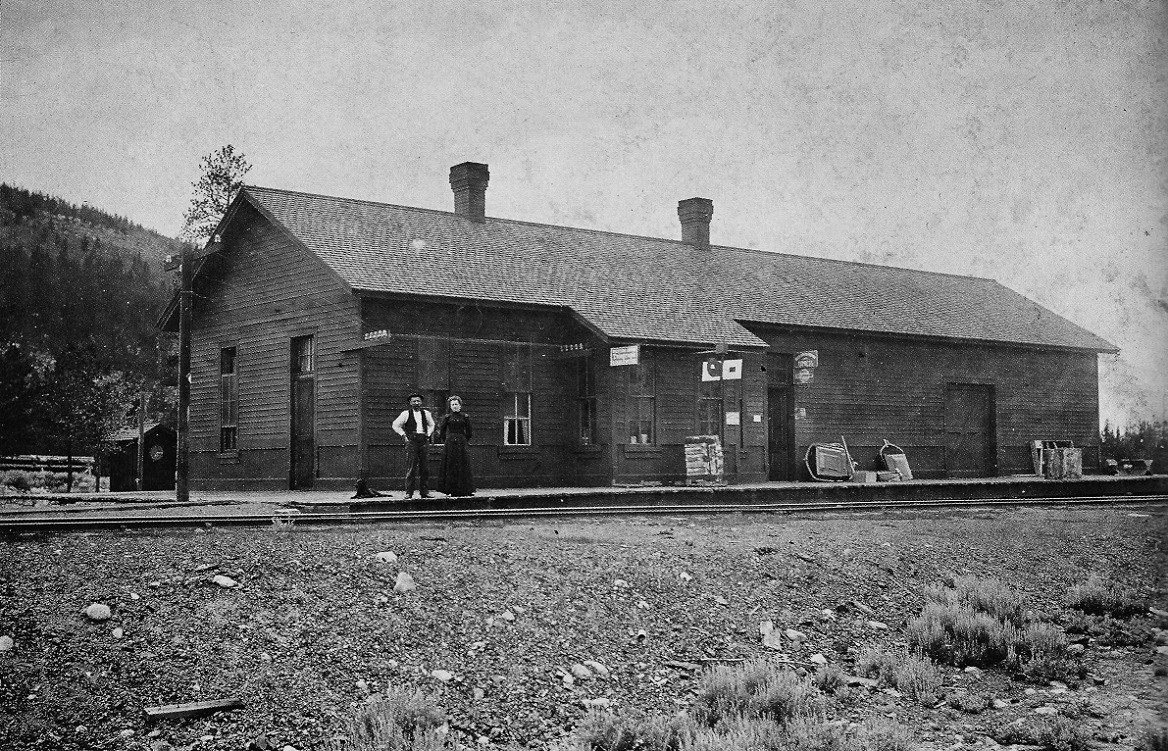 Otto Westerman photo, in Digerness, The Mineral Belt, Volume II, page 188. The depot looked like this during DL&G days, about the time that Jimmy's map was drawn. Roper pointed out the depot dog on the platform. And that's quite a few telegraph lines running into the depot, eh South Park? 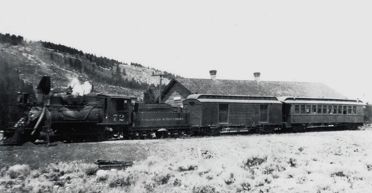 The passenger train at the depot, powered by a big B-4-E freight engine, in the early 1920s. One wonders whether the D&RG bridge and wye are still in place to the left. 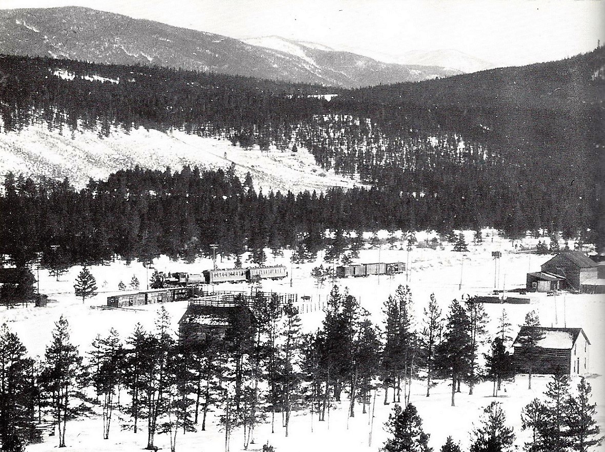 C&S Company photo, in Digerness, The Mineral Belt, Volume II, page 186. Finally, our old friend, the Denver Water Board special of January, 1929, spotted on the main between the house track and the depot, with the stock yards at the bottom left foreground. The only photo that I've ever seen of a passenger train at Dillon with the locomotive pointed north.
Jim Courtney
Poulsbo, WA |
Re: Ten Mile Stations of the D&RG
|
In reply to this post by Jimmy Blouch
While waiting for another one of my maps to appear I thought I would post this one.
This map shows D&RG surveys in the Dillon area during 1882. Note there is also a DSP&P survey, bypassing Dillon headed to Grand River. D&RG completed laying track to Dillon November 22, 1882. Jimmy 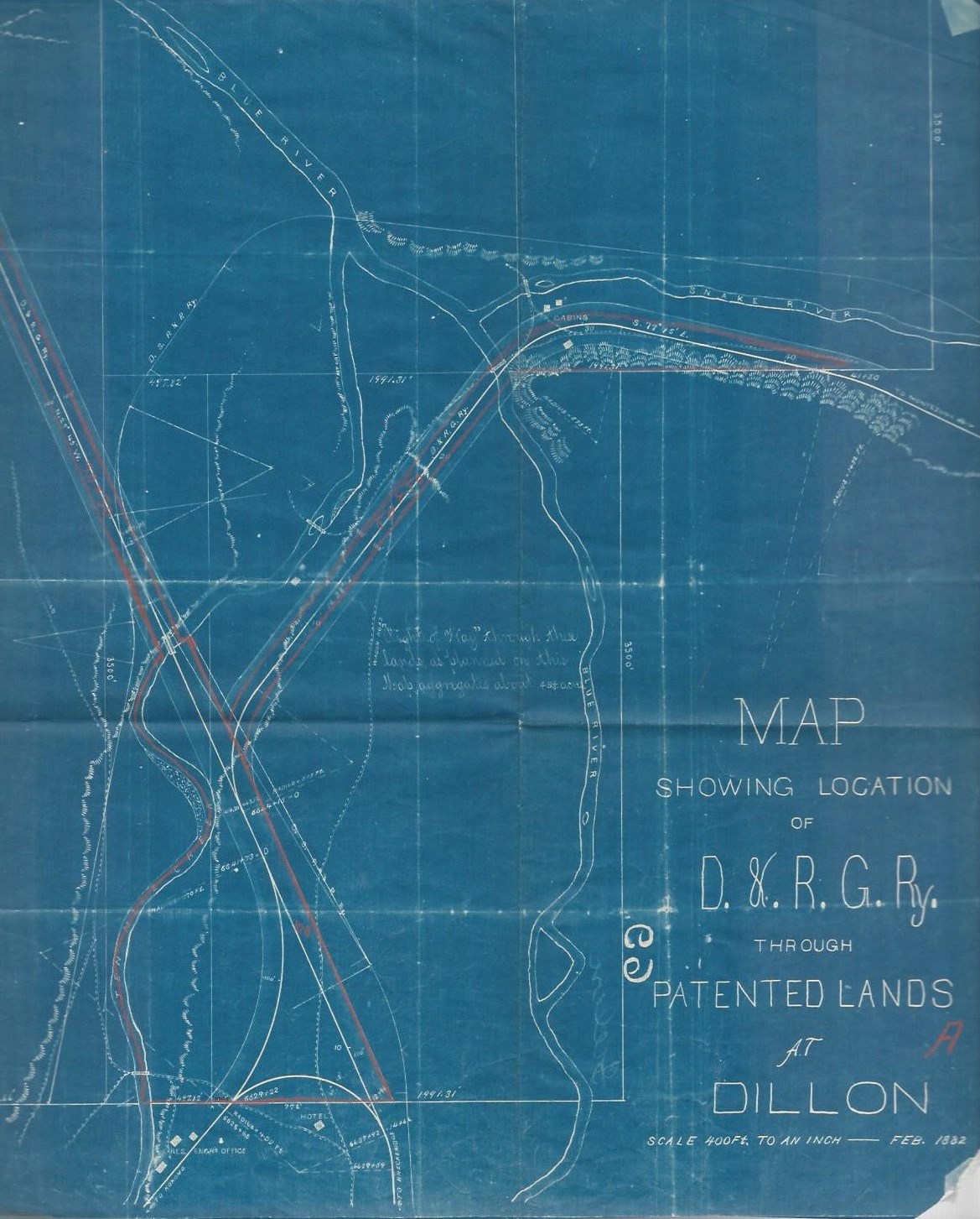
|
Re: Ten Mile Stations of the D&RG
|
This post was updated on .
Priceless map, Jimmy!
Answers many questions and straightens out misconceptions on my part. 1) The D&RG mainline from Frisco entered Dillon on the west leg of the wye, not the south leg. 2) Had the D&RG built all three of its surveyed routes off the line from Leadville and Fremont Pass, Dillon would have been quite the rail junction, with several D&RG lines branching out: a) Northwest, down the Blue River valley, to the Grand River (instead of just the stock yard). b) East up the south bank of the Snake River, perhaps to Montezuma and Sts John. c) And finally a line to the southeast, headed up the Blue River to Breckenridge, off the south leg of the wye. One wonders at what might have been at Dillon (depot, water tank, roundhouse, section houses, etc) if General Palmer hadn't run out of money. The South Park might never had built into Dillon had all this happened. 3) The South Park spur that crossed the D&RG at grade, just south of the stock yards, was initially much longer, following the west Bank of Tenmile Creek up in to "downtown" Dillon proper. The valuation map that I posted does show a dotted extension of the spur in that direction. One wonders what was at the end of that long spur. 4) The original South park survey shows a track diverging to the northwest off the mainline, near the D&RG wye, and linking up with the D&RG mainline north, just south of the spur crossing the D&RG. Had this line actually been built, there would have been three bridges across Tenmile Creek, all in a row, instead of just two! I will disagree with you about the DSP&P survey, though. It isn't headed to the Grand River, it is turning to the east past the site of the future depot and crosses the Blue River, below the confluence of the Snake River and Tenmile Creek with the Blue. It is then headed east on the north bank of the Snake River, on its way to Keystone. It is an accurate survey of the line that was actually built, hoping to link up with the Colorado Central above Silver Plume, to form the "Short Line" to Leadville. The South Park bridge across the Blue was an iron through truss bridge, and survived until abandonment: 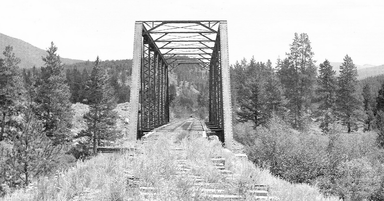 In the Klingers' C&S Highline Memories . . . Keep the maps coming Jimmy, I'm learning lots of new stuff here! Jim
Jim Courtney
Poulsbo, WA |
Re: Ten Mile Stations of the D&RG
The blue line continuing north from where DSP&P turns east is the D&RG ROW line which I stated in error as being DSP&P survey line. However, I do not think that area where the DSP&P line turns east is the Dillon location. To me Dillon area is at the bottom of the map where the "wye" type lines are shown. That would be where both the D&RG and DSP&P entered Dillon after crossing Ten Mile Creek. The DSP&P curved east past the depot and crossed the Blue River east of Dillon. As a result it would appear the DSP&P survey line bypassing Dillon was not used. Jimmy |
|
Administrator
|
In reply to this post by Jim Courtney
Passenger trains could just as easily backed to Dillon as run head end first from either direction. Seems logical that in snow they would not have backed up to Dillon.
All trains arriving into Dickey would have taken coal and water and probably on arrival. Switching in Dillon or Keystone in clear weather would almost certainly have been accomplished at the discretion of the crew. The photo of the engine in the middle of a cut is proof of this. Engine first last or middle could have been common, remember in later years, all freight switching to Dillon and Keystone was done by one of the helpers of the Eastbound freights. They were not seperate trains unless a stock extra. |
Re: Ten Mile Stations of the D&RG: Dillon
|
In reply to this post by Jimmy Blouch
Jimmy's two period maps from 1882 and c1890 got me thinking about how the Dillon/Keystone branch was operated in the early years, and I recalled this photo:
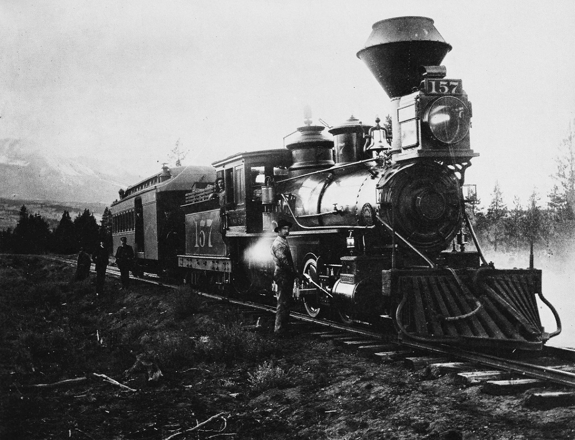 C.C. Rogers photo, in Digerness, The Mineral Belt, Volume II I've always loved this late 1880s photo of "cold water" Brooks mogul 157 and one of the "Bowers-Dure” combines, either 703 or 704 (post 1885 numbers). The photo, per the caption, was taken between Dillon and Keystone, with the Blue River valley in the distance. One of the problems of aging is that I have trouble remembering where I read things, wish I had made better notes over the years. I could swear that I have read that in the 1880s into the 1890s, a mixed train served the Keystone branch from Keystone to Breckenridge and return every day -- my recollection is that the train left Dillon northbound early every morning to Keystone, turned, then ran the entire distance back down the branch to Dillon, Dickey and then used the mainline to reach Breckenridge for a late morning arrival. A mid afternoon departure from Breckenridge retraced the above route to Keystone, where the train turned and returned to Dillon, to tie up for the night. The August, 1889, South Park timetable on the inside end covers of the Mac Poor Memorial Edition. . . does show a pair of mixed trains operating on the mainline between Dickey and Breckenridge: Train 482 left Dickey at 9:15 AM, arriving at Breckenridge at 10:15 AM. Train 483 departed Breckenridge at 3:15 Pm and arrived at Dickey at 4:25 PM Unfortunately, the end cover timetables do not include the branch lines, so info on the Dickey to Keystone segment isn't included. Anyone have an early South Park timetable that includes these trains on the Keystone branch? There were wyes at Keystone and Breckenridge. If the train followed the daily route in my failing memory, it would seem that the engine and combine would have to be turned at Dillon at least once in 24 hours, possibly on the D&RG wye in Dillon, as Jimmy suggests.
Jim Courtney
Poulsbo, WA |
Re: Ten Mile Stations of the D&RG: Dillon Mixed on D,SP&P
|
Back in the first Dillon thread http://c-sng-discussion-forum.41377.n7.nabble.com/Freight-trains-at-Dillon-or-Keystone-td1868.html#a1885, Chris Walker posted this Otto Westerman photo of a DSP&P mixed train somewhere between Breckenridge and Dillon:
http://http://digital.denverlibrary.org/cdm/singleitem/collection/p15330coll22/id/72032 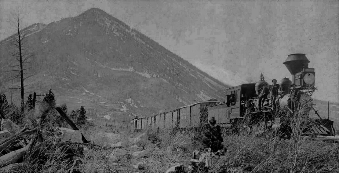 The original print is in sepia tones, but (unlike Paul Simon) I think everything looks best in black and white. One wonders if this is the north bound mixed, train number 483, headed back to Dillon and Keystone from Breckenridge. To me the mountain peaks in the background look like the Tenmile Peaks at the mouth of Tenmile Canon. If so, Frisco would be directly behind the locomotive. Perhaps some of you "Then and Now" experts can find the location on Google maps. (  Do the "street views" work, if this location is now under the water of Dillon Reservoir?). Do the "street views" work, if this location is now under the water of Dillon Reservoir?).
The photo must date from the early 1890's, about the time of Jimmy's first map. The locomotive, D,SP&P number 268 is one of the Baldwin 2-8-0s delivered in December of 1890. Later, it would be re-classed as a B-4-D on the C&S and be renumbered to 65.
Jim Courtney
Poulsbo, WA |
Re: Ten Mile Stations of the D&RG: Dillon Mixed on D,SP&P
|
As per my caption....it is indeed coming into Frisco Jim.
 I'm leaning to Dickey bound from Leadville with Frisco ahead of the Loco but with uncertainty as to the locations of where the line(s) were exactly. That's Chief Mountain in the background. 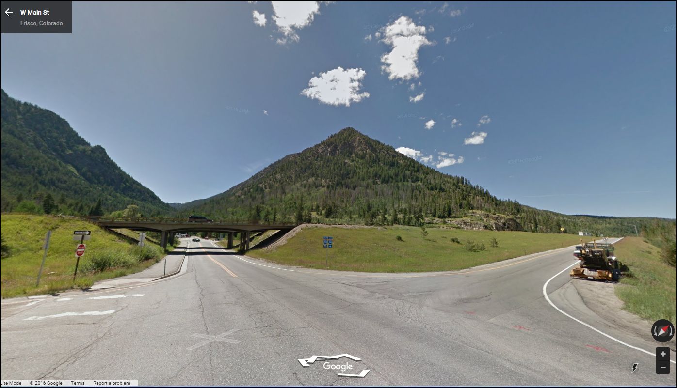
UpSideDownC
in New Zealand |
Re: Ten Mile Stations of the D&RG: Dillon Mixed on D,SP&P
|
This post was updated on .
Good detective work, Chris.
When the South Park / C&S mainline exited the mouth of Tenmile Canon, it didn't enter Frisco proper but turned back around to the east toward Dickey, around the north flank of Mount Royal. The Frisco siding was located there: 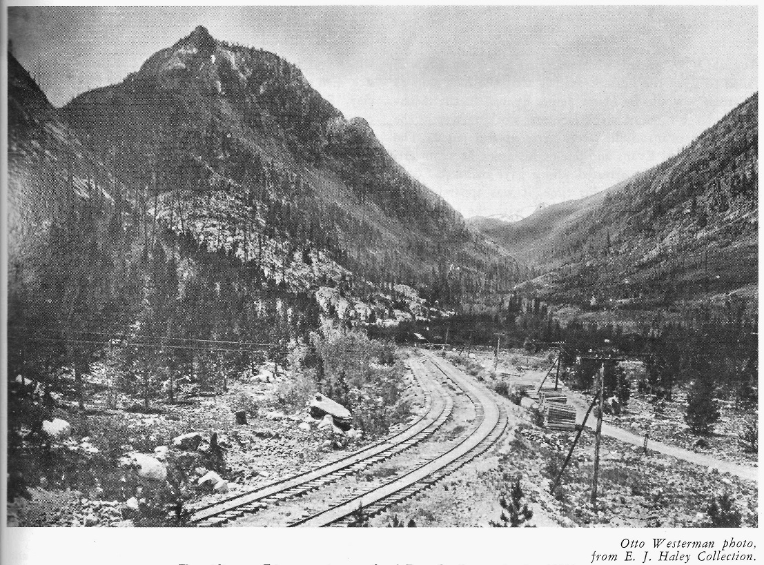 From Mac Poor's Denver, South Park and Pacific, Memorial Edition. This Otto Westerman image is likely a contemporary of the mixed train image, looking west: Mt Royal on the left frame, Wichita Mountain to the left center, North Tenmile Creek dead ahead with Chief Mountain to the right frame. The town of Frisco proper would have been in the flats to the right frame. The distant mainline curve to the left marks the entrance to Tenmile Canon. So, I guess I would agree, the mixed is probably near or just past the Frisco siding, heading southeast toward Dickey -- so probably not on the Dillon branch, unless is was just north of Dicky, northbound to Dillon. Your explanation is likely the best. I've never seen anything on maps other than the D&RG and C&S mainlines with respect to Frisco. Here is hoping that Jimmy's maps can shed new light on how things were arranged there.
Jim Courtney
Poulsbo, WA |
Re: Ten Mile Stations of the D&RG: Dillon Mixed on D,SP&P
|
This post was updated on .
Snap!
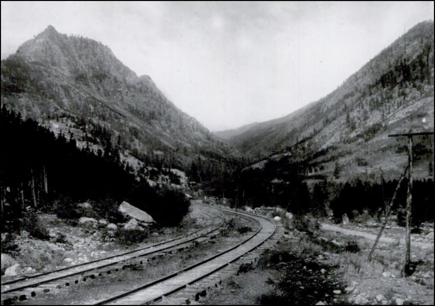 Summit County Hist. Soc. 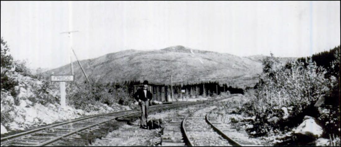 Summit County Hist. Soc. X-8544 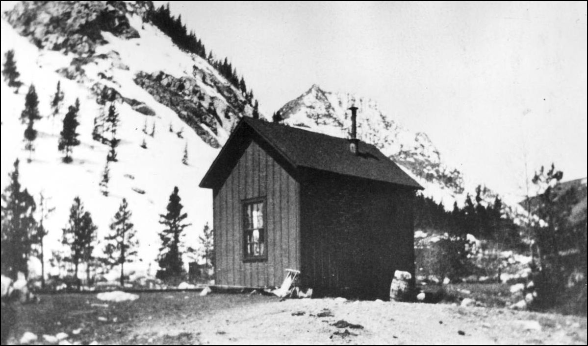 http://digital.denverlibrary.org/cdm/fullbrowser/collection/p15330coll22/id/8287/rv/singleitem/rec/3 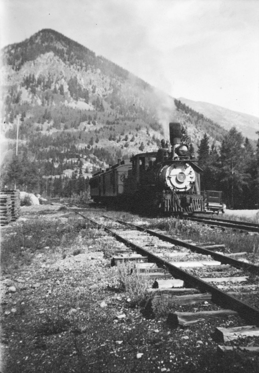 Summit County Hist. Soc. The D&RG line through Frisco proper X-8543 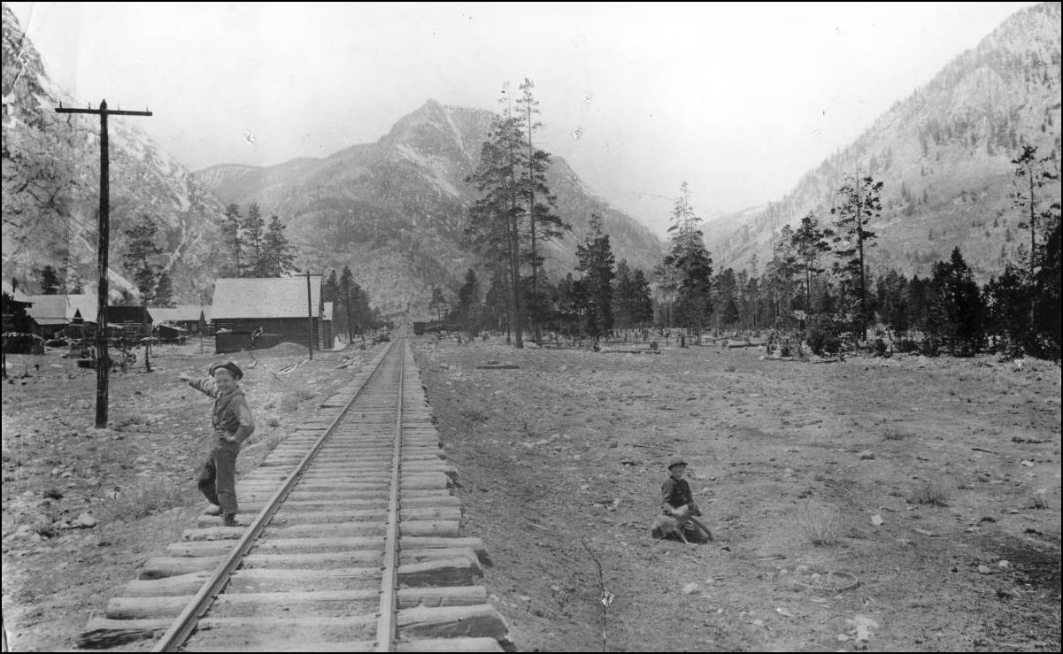 http://digital.denverlibrary.org/cdm/fullbrowser/collection/p15330coll22/id/8370/rv/singleitem/rec/40 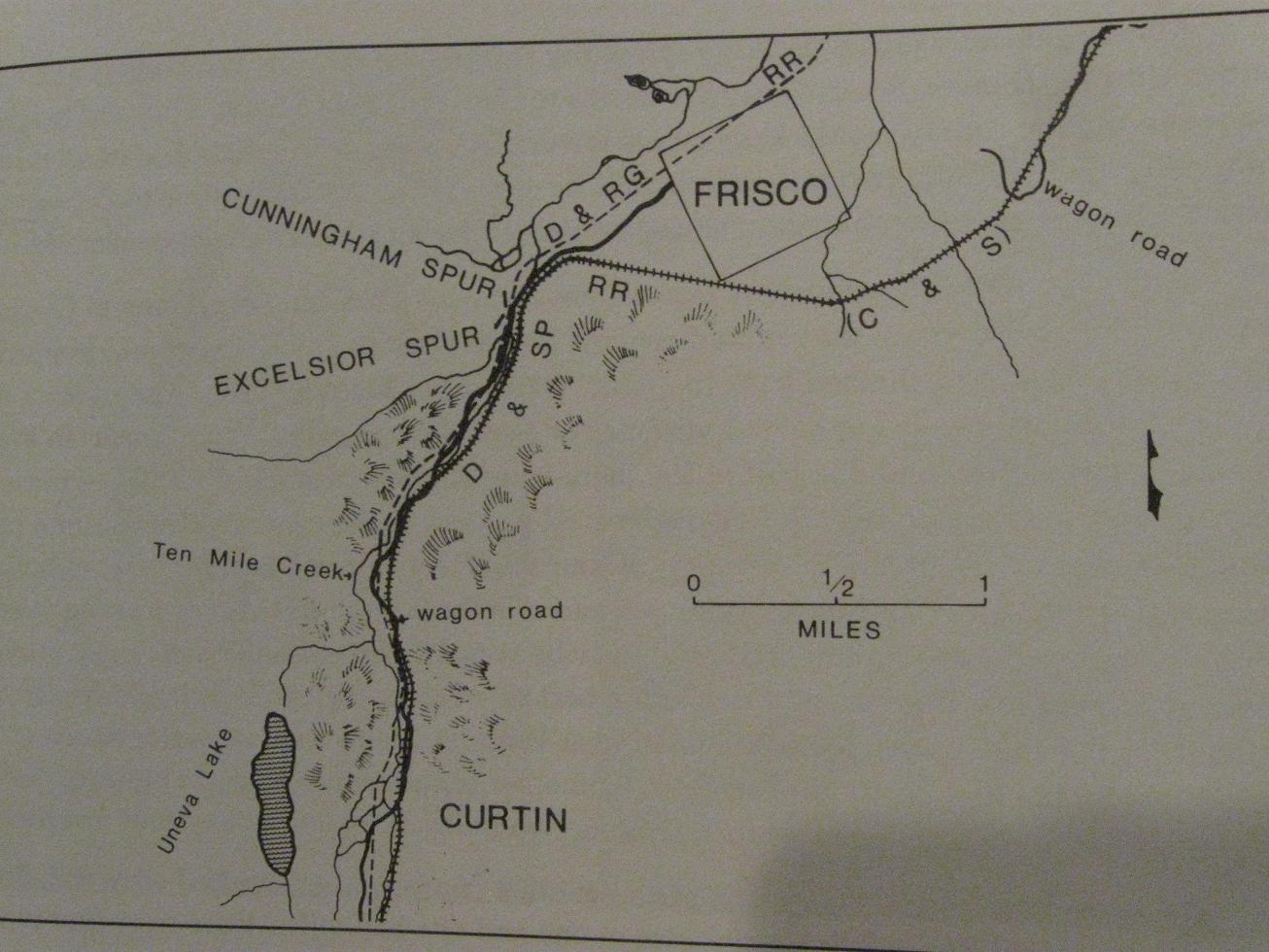 Roadside Summit Part II:The Human Landscape. Sandra F. Pritchard, Summit County Hist. Soc. Publication 1992 Views of the Tenmile range from what is now under the Dillon Res. WHJ-541 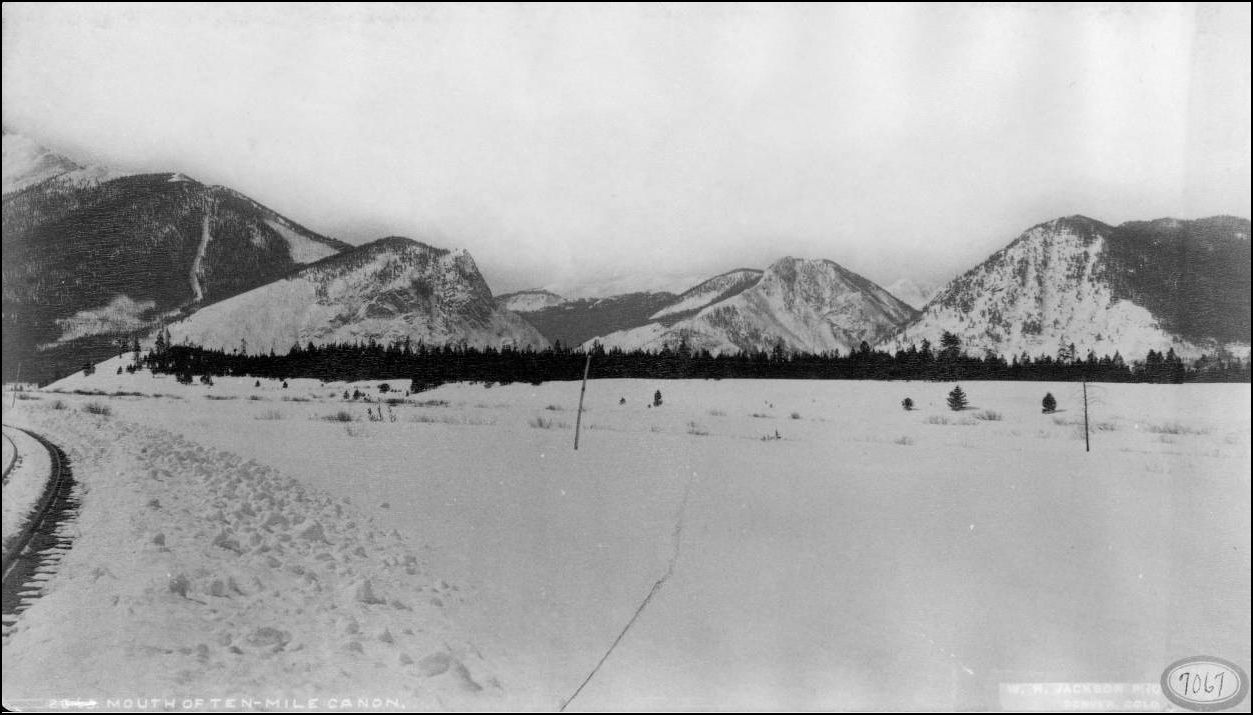 http://digital.denverlibrary.org/cdm/fullbrowser/collection/p15330coll22/id/37655/rv/singleitem/rec/4 CHS.J919 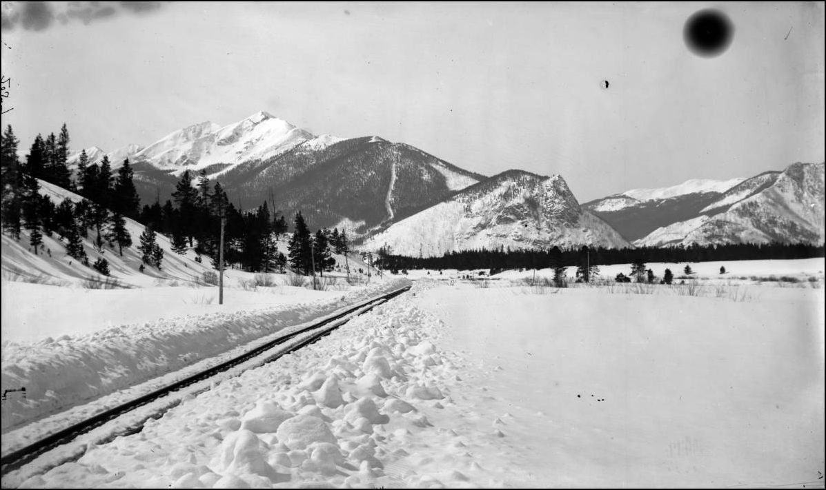 http://digital.denverlibrary.org/cdm/fullbrowser/collection/p15330coll21/id/7135/rv/singleitem/rec/151 CHS.J920 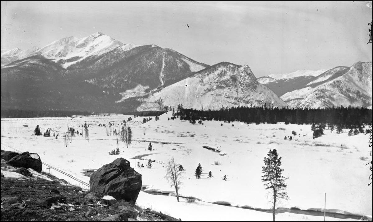 http://digital.denverlibrary.org/cdm/fullbrowser/collection/p15330coll21/id/7136/rv/singleitem/rec/109
UpSideDownC
in New Zealand |
Re: Ten Mile Stations of the D&RG: Dillon Mixed on D,SP&P
|
Awesome!
Keith Hayes
Leadville in Sn3 |
Re: Ten Mile Stations of the D&RG: C&S at Frisco
|
This post was updated on .
In reply to this post by Chris Walker
Great overview of Frisco, Chris.
A couple of more: 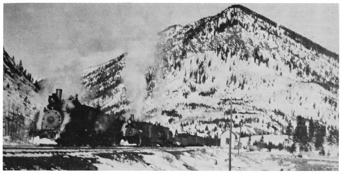 C.O. David photo, in Digerness, The Mineral Belt, Volume II A three engine east bound freight waits at Frisco siding for a meet, c1908. The little second depot has been repainted in the grey and green scheme. 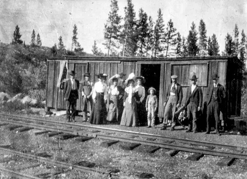 http://c-sng-discussion-forum.41377.n7.nabble.com/http-digital-denverlibrary-org-cdm-ref-collection-p15330coll22-id-55333-td2856.html#a2868 The first Frisco depot. 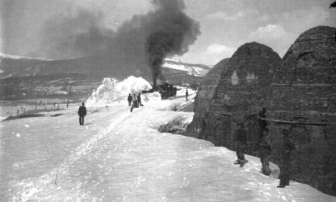 Summit County Historical Society. A two engine rotary train on the C&S works westbound past the charcoal kilns. I believe this is southeast of town on the mainline between Dickey and Frisco siding. Anyone know for sure? Jim
Jim Courtney
Poulsbo, WA |
Re: Ten Mile Stations of the D&RG
|
In reply to this post by Jimmy Blouch
The map of Dillon I wanted to post is still in hiding.
Now that the conversation has turned to Frisco here are a couple of maps. Though the "South Park" line was in place, neither map shows it. The first map is a portion of the first Dillon map I posted. The second map dates from around 1896. D&RG had no water tank at Frisco. Early on they had a depot but by 1891 it was gone. Jimmy 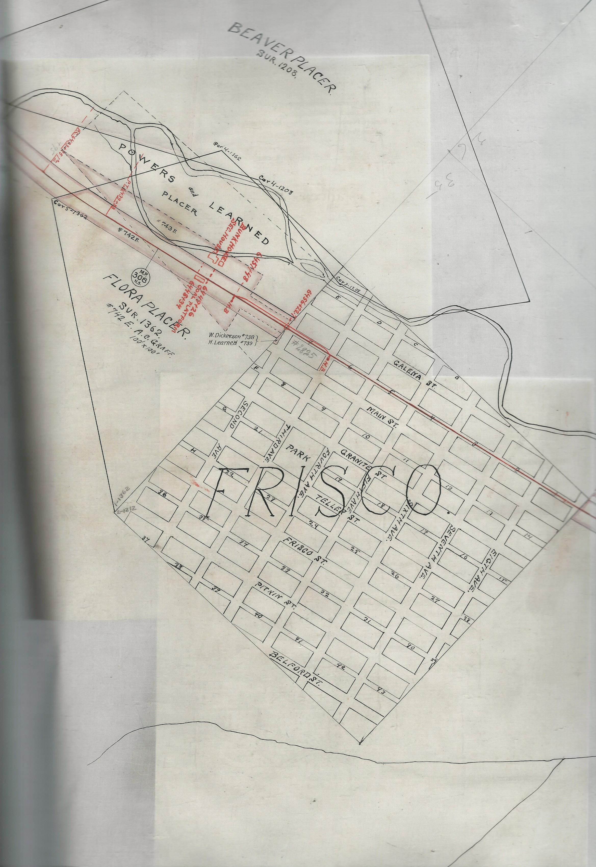 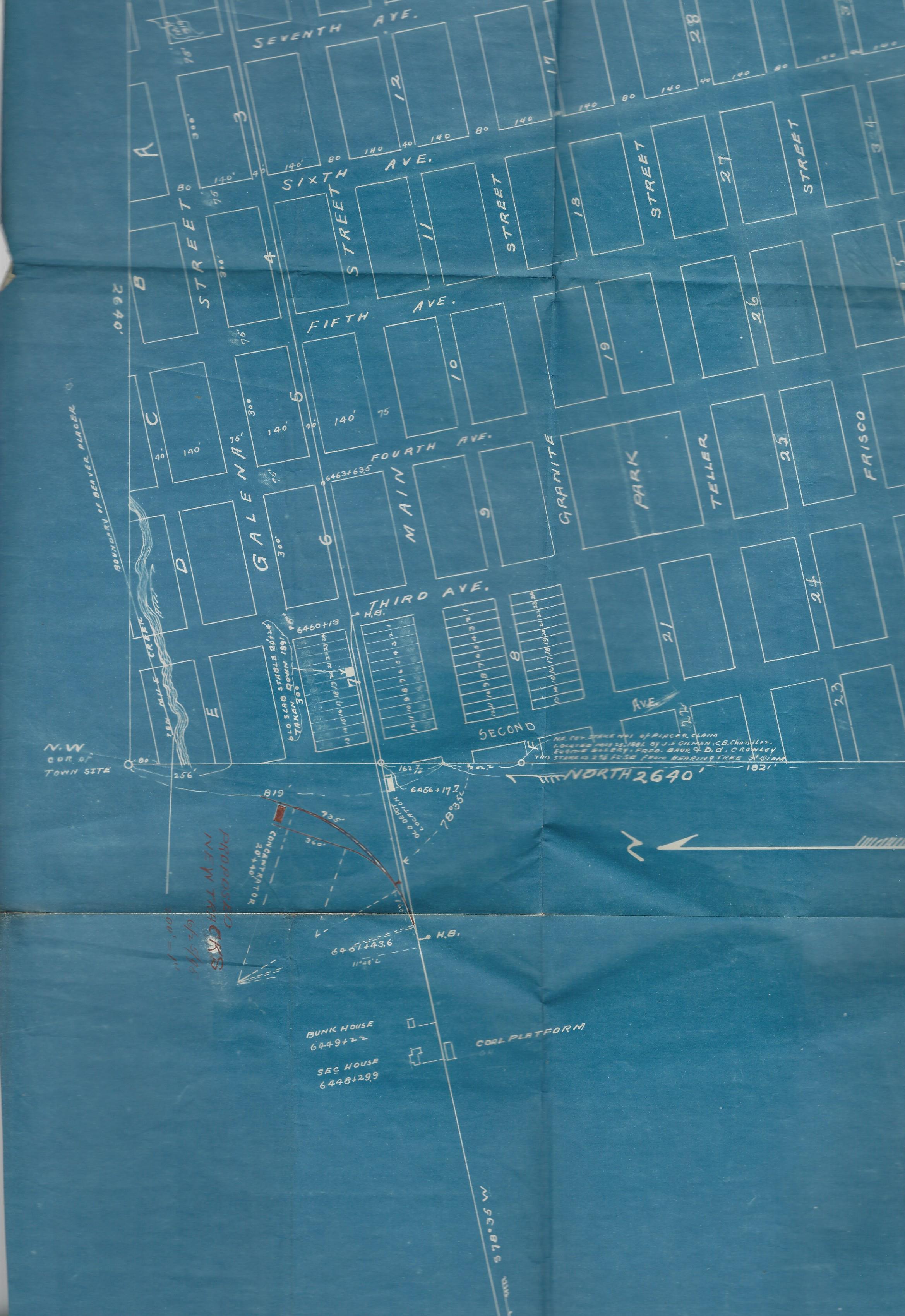
|
Re: Ten Mile Stations of the D&RG: Frisco Maps
|
Great stuff, Jimmy!
To resize your first map: 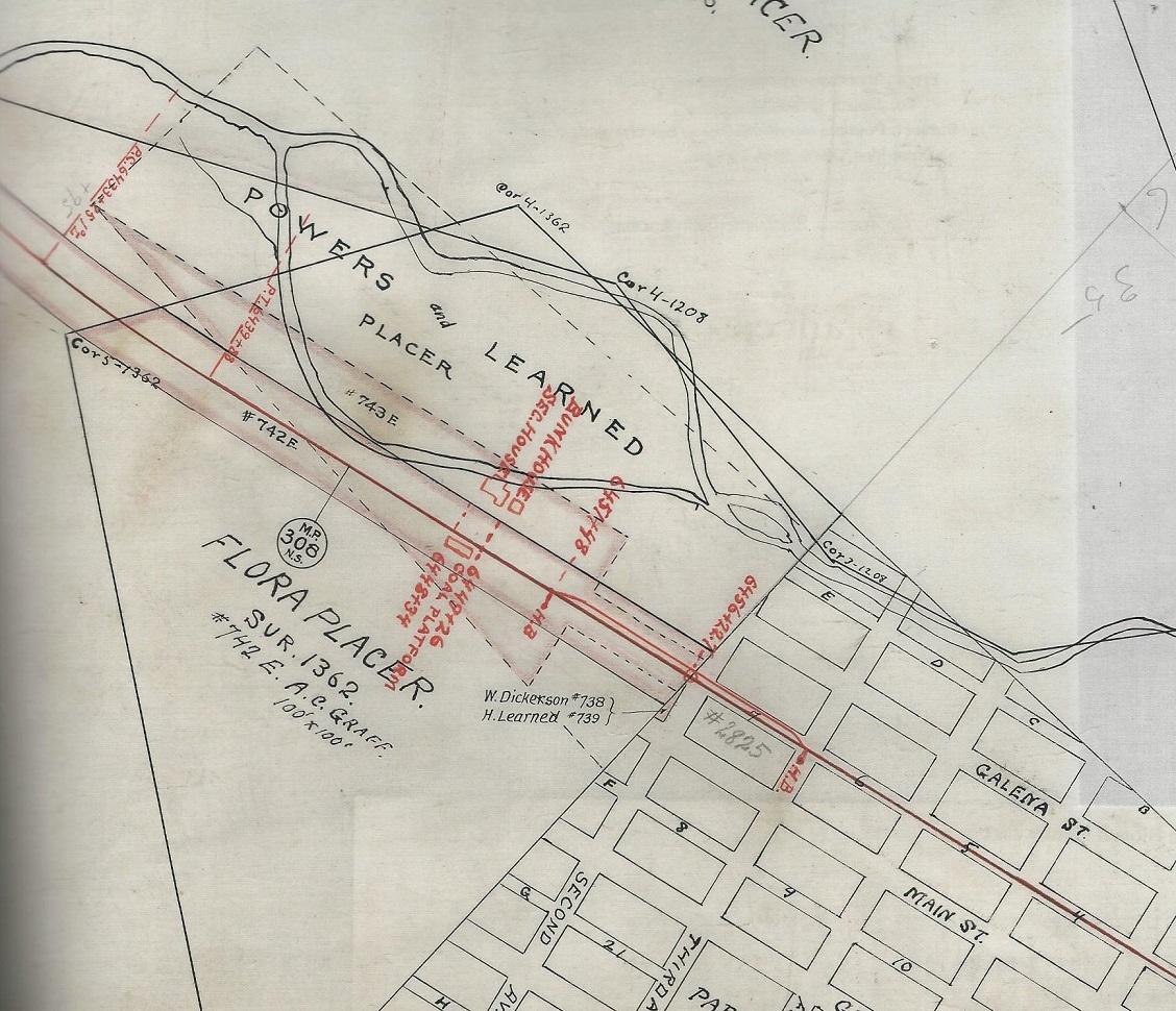 The D&RG entered the mouth of Tenmile Canon to the left is my assumption. Then the photo that Chis posted above, when enlarged, would show the D&RG siding on the right of the main, as the line headed toward the canon mouth: http://digital.denverlibrary.org/cdm/fullbrowser/collection/p15330coll22/id/8370/rv/singleitem/rec/40 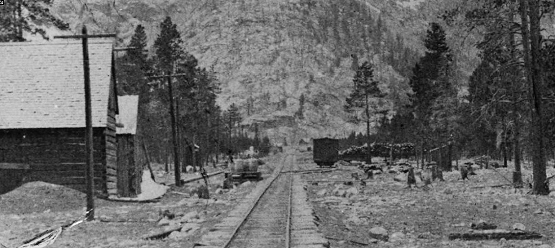 Looks like a D&RG 24 foot boxcar spotted on the siding just opposite the "2825" on Jimmy's map. I can't make out the coal platform or section structures in the distance though. Nothing looks like a depot on the left of the main. Was this photo after the depot was removed? Jimmy's second map shows proposed tracks coming off the D&RG at the the far end of the siding, to an un-named concentrator. The only concentrator at the mouth of Tenmile canon that I've read about, on the northwest side of the D&RG was the Excelsior Mine concentrator: 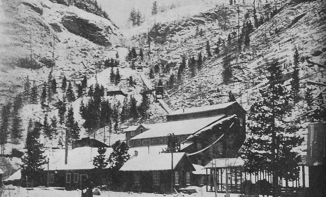 In Gilliland, Summit, page 138. Do you think the "concentrator" on the second (blue) map is the Excelsior, or was it located further to the south, in a ways from the mouth of Tenmile Canon? Again, thanks for sharing these marvelous maps here. Jim
Jim Courtney
Poulsbo, WA |
Re: Ten Mile Stations of the D&RG: Frisco Maps
|
It appears I need to work on sizing my maps, some show up small and others too large.
Yes, to the left is entrance to Ten Mile Canon. The depot was on the right and it and section buildings were beyond the west switch in this view. This appears to be an early view and perhaps prior to construction of buildings. I have seen reference that the early depot was either a car body or car placed on siding. I have another map of Frisco that shows the depot location. Will try to get that posted. The blue print pertains to a spur track for the B&R Gold Refining Co, dated 1895. It does not appear that is the Excelsior concentrator is that shows up down at Cunningham Spur. Jimmy Sorry this image is too large again 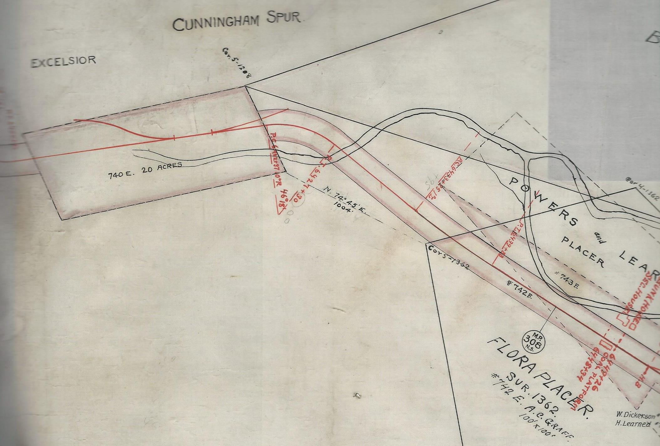 |
Re: Ten Mile Stations of the D&RG: Frisco Maps
 Jimmy, when resizing images for this forum, they turn out best with horizontal width of 1000-1200 pixels. OK, so now I understand, the D&RG crossed Tenmile Creek then made a left turn to enter the canon. The Cunningham and Excelsior spurs are just inside the mouth of the canon. I just found a couple of "Images of America" books on Amazon regarding Frisco and Tenmile canon. I'm hoping that they will better illustrate some of the mines on both the D&RG and C&S sides of the canyon. I've walked and biked the old C&S grade in the canon a couple of times, but still have difficulty envisioning how everything looked and related to each other in the old days. You're maps are helping me understand things better.
Jim Courtney
Poulsbo, WA |
Re: Ten Mile Stations of the D&RG: Frisco Maps
|
So, if there were no water tanks in Frisco and Dillon proper, did the D&RG have a free standing water tank somewhere between the two stations?
And Upside Down Chris, you are the mining guru, any images of the Cunningham or Excelsior operations?
Jim Courtney
Poulsbo, WA |
Re: Ten Mile Stations of the D&RG: Frisco Maps
|
This post was updated on .
Nothing comes to mind between Frisco and Wheeler other than the Mary Verna and Powerhouse Siding which you did in some other thread, http://c-sng-discussion-forum.254.s1.nabble.com/Rural-electrification-tp4229p4236.html
The Water Tank was at Wheeler, and I think there is very small mention of the mines in Uneva Gulch in Summit or Mining The Summit. EDIT: link url updated 
UpSideDownC
in New Zealand |
Re: Ten Mile Stations of the D&RG: Frisco Maps
|
Wheeler was the D&RG name for the site the C&S referred to as Solitude, correct? If so, we're the two tanks proximate?
Dad refers to this location as "Wheeler Junction." Did one of the railroads ever anticipate a branch from Wheeler, or is that a highway overlay in anticipation of the road over Vail Pass?
Keith Hayes
Leadville in Sn3 |
Re: Ten Mile Stations of the D&RG: Frisco Maps
|
Wheeler Trail is an old sheep trail from Wheeler Flats over the 10-mile range to just south of Breckenridge. I wonder if Wheeler Junction refers to a junction on the trail, rather than railroad or highway?
(Just speculation; I have no idea where the name comes from.) Cheers, Jeff. |
«
Return to C&Sng Discussion Forum
|
1 view|%1 views
| Free forum by Nabble | Edit this page |

