Freight trains at Dillon (or Keystone)?
123456


123456
Re: Freight trains at Dillon?
|
Probably not.There are several DPL and History Colorado photos credited in books that don't seem to have made it to the Digital site,but keep looking,they'll show up some day.One I'd like to see is a long distance panoramic view of Nathrop showing the Nachtrieb Hotel ,a part of the town,and a D&RG loco idling on one of their sidings-located in CRA#12.Speaking of photos ,David Tomkins' Como Depot Facebook page has 2 photos-C&S 9 and caboose 1002.From the fact they have PROOF stamped on them,I'd suppose they're on Ebay.
|
|
In reply to this post by Jim Courtney
As Weston keeps holding out on us with his sources, try this one from the Park County Archives
http://www.parkcoarchives.org/photo_inventory/inventory_2800to2899/2881.jpg Could be Dillon bound.... 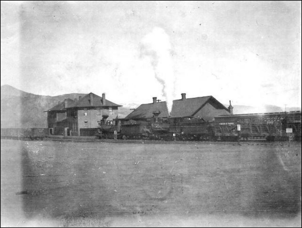 2881. Como Railroad. Early 1900s. Train with Como Hotel and depot. Source: Wadley Family Collection
UpSideDownC
in New Zealand |
|
Chris, I think you are correct. Unlike the Powderhorn, the C&S did not traverse the area during a time when ranching became widespread enough to justify entire trains to move stock. The operations must have been more localized, and the ranchers needed to thin herds and dispose of steers in quantities that only justified 1-2 carloads.
It is peculiar that the C&S had so many stock cars, though. The roster I have consulted lists 119 stock cars, or about 8% of the fleet. While this is a modest number compared to the 778 boxcars and 503 coals, it is still quite a few pieces of rolling stock to stash about the railroad only to move them a couple carloads at a time periodically. Also, this compares with 448 stock cars on the D&RG (17% of that road's fleet) during a similar timeframe.
Keith Hayes
Leadville in Sn3 |
|
This post was updated on .
Sorry, Keith, I just can't accept that concept.
See my June 17th post on page 2 of this thread. There is written documentation from Summit County records that the Blue River ranches shipped livestock out of Dillon in vast numbers, commonly in 10 to 20 car trains, from as early as 1903 until as late as the 1930s. We just haven't found many pictures of them yet. I think that this is a pitfall that we must acknowledge as model builders of the C&S: Model builders try to reproduce what they see (in real life or in vintage photos) rather than what we read about and have to imagine. So, if Otto Perry takes several photos of 1 or 2 stock cars in the passenger train, we tend to assume that was the norm. Without written context, we cannot know if Otto considered them the norm or, rather, an incredible anomaly, prompting the photos. Take Chris' Como photo of 1902-1903 posted above. We only "see" two stock cars in the photo, but cannot know if there are another 15-20 cars to the right of the frame, with 2 more helpers in front of the caboose. That is what impressed me so much about Derrell's "Eight wheel caboose" thread: The incredible amount of information from written records that Derrell had patiently sifted through to draw conclusions. Many of my cherished beliefs about C&S cabooses, established by study of only photos, without context, turned out to be incorrect.
Jim Courtney
Poulsbo, WA |
|
Administrator
|
Jim,
I don't think we can possibly think the stock cars in passenger trains were the norm at all. What we now know is that it happened on occasion, and that can't be denied. In fact, that they were in occasional passenger consists would have made it quite an interesting subject to Otto Perry and others, but still rare. I'm quite sure that an occasional reefer and boxcar were also run as express on the passenger train, but that probably would have been even more rare. The reason it makes sense to run stock cars in the consist was because it was a way to get around the 12 hour law to release the critters. It was probably never necessary to run stock cars in the passenger train between Denver and Como in either direction, and was also not necessary to run stock cars in the consist between Leadville and Como in either direction. It was necessary across the subdivisions at Como because of the way the regular freights were operated on a two day schedule twice a week. A 20 car stock train between Denver and Dillon would have been run "Extra", but would still have had to overnight at Como. Most likely, that would have been run on Friday and Saturday. East End Engine crews would have had to hole up at Como until their engines were returned late Saturday, and then run light back to Denver that night or Sunday. I don't know how big the pens were at Como,, but it seems to me that 20 cars of stock would be a sizable population. The only time the Como stock pens came up in my conversations with Doug Shnarbush was when he told a story about a government revenue agent who came up there looking for a still in the 30's. One of the local guys had a still down by the lower tank where the stock pens were and the guy went down and dumped all his stuff into the troughs, so the agent found only a bunch of drunk hogs. So, safe to say that hogs were transported as well, sober or otherwise. |
Re: Freight trains at Dillon (or Keystone)?
|
This post was updated on .
I saw this photo on eBay, one I've never seen before, so I bought a copy to add to this thread:
 Okay, so it's not a freight train at Dillon. But it is a freight engine on the daily Leadville passenger train. The photo is not dated, but considering that there is not an RPO on the train, just a 4 door baggage car (is it number 1 or number 2?), the photo must have taken place between 1917 and 1931, when RPO operations were limited to the "Denver & Como RPO". The locomotive, B-4-E number 72, gives other clues as to date: The rebuilt "modern" tender, the CB&Q style box headlight, the Ridgeway spark arrestor, the modern sanding pipes all suggest post 1918. The steel pilot beam still has a wood slat pilot attached. To me this suggests 1922-1925, based on dated Otto Perry photos of engines with similar features. Note the Dillon depot still is painted in the light grey with green trim at this date--note also the painted light bands on the two chimneys. The darker red and green scheme is still in the future. There are little piles of cinders on either side of the switch stand, suggesting that the switch stand was possibly used as a marker, to spot the passenger train at the depot. At this point, I've still not seen a photo of the passenger train at the depot, with the engine headed north toward Keystone. Is it possible that both the eastbound and westbound passengers were backed from Dickey to Dillon, and both returned to Dickey engine first?
Jim Courtney
Poulsbo, WA |
Re: Dillon / Keystone Operations Revisited
|
This post was updated on .
Quite a few years ago, I purchased two sets of 1918 C&S Valuation Maps from the Colorado Railroad Museum, the sets that covered Platte Canon through Como, my primary C&S interest.
Jimmy Blouch's excellent thread on the D&RG Blue River branch (http://c-sng-discussion-forum.41377.n7.nabble.com/Ten-Mile-Stations-of-the-D-amp-RG-td6164.html) prompted me to recently purchase the two sets of maps covering Como to Leadville, via Boreas Pass, Breckenridge and the Ten Mile. Tucked into the last several pages of the second Leadville set were maps for the Keystone Branch, including the Dillon station map:  This busy map, showing the bridges over Ten Mile Creek, the C&S house track and the C&S depot area, was colored in at the top of this thread. Turns out, the house track at Dillon was the only double ended siding on the entire Keystone branch, at least by 1918.  This right hand continuation of the Dillon station map shows how the C&S mainline made a near 180 degree curve to the east, from the crossing of Ten Mile Creek to the crossing of the Blue River. Just east of the Blue River bridge was a spur, Sterne's Spur, connecting to the mainline at the east (by compass) end. Note the spur had its own station sign, a couple of platforms for loading / unloading freight and a log skidway was located on the main between the bridge and the spur switch. Mac Poor lists the spur as 223 feet in length. But by 1918, Sterne's spur was much longer:  The spur was extended to the north, along the east bank of the Blue River three-quarters of a mile or so, to a power house serving some sort of industry, a placer mining operation perhaps? The history book Roadside Summit, The Human Landscape describes a shingle mill near this location and lime kilns just a bit further east. Note that the end of track for the spur, next to the power house, seems to have an elevated trestle or some such, for coal unloading. Further to the east, headed toward Keystone, the mainline crossed the Snake River, on a pile trestle, just before mile post 122:  Just east of milepost 122 was a 599 foot spur that Mac Poor does't list, connected to the mainline at the east (compass) end. The 1918 valuation map lists the spur as Colligan (any relationship to "Curly", the engineer?). Two platforms with ramps at each end are clearly drawn on the south side of the spur, both connecting to the wagon road from Dillon to Montezuma and Peru Basin to the east. Who knows what was loaded / unloaded here -- local hay, perhaps, or maybe ore from the mines to the east. The valuation map for Keystone itself was both surprising and disappointing:  A single 700 foot spur, connecting to the mainline at its west end, served a coal bin, loading platform and the sawmill located here. The mainline simply stopped just east of the spur switch. The original mainline of the DSP&P to the depot and beyond, is shown as a dotted line, out of service. There is no representation of the wye that Mac Poor describes here at the end of the branch line. But the map does jive with the only photo of Keystone that I've seen: 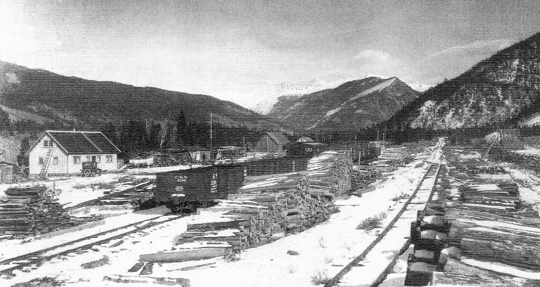 November, 1928. Colorado Historical Society, Whatley Collection, negative F15169. In the Klingers' C&S Highline Memories . . . Looking east down the mainline, there is a single post used as a bumper of sorts at the end of track. The disconnected mainline to the depot remains visible in the distance. Clearly, any in bound freight cars delivered to Keystone were pushed upgrade ahead of the locomotive. The track layout of the spurs at Colligan and Keystone, finally explain what's going on in this photo that we've discussed in the past: 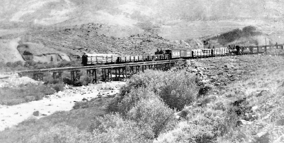 The locomotive and cars are backing across the Snake River trestle just below Colligan spur. The freight cars in front of the engine (loaded flats with mine props, two empty Peninsular coal cars, the boxcar) were likely pulled from the facing spur at Keystone, while the 2 or 3 boxcars behind the tender were likely pulled from the trailing spur at Colligan. I still don't understand D&RG boxcars north/east of Dillon. Perhaps they were inbound loads of supplies, taken in interchange with the D&RG at Leadville, consigned to Colligan spur for trans-shipment to the mines of Montezuma or Peru Basin. Now empty, perhaps they are being returned to Leadville. This new (to me) information has changed my understanding of the Keystone branch: By 1918, there was no mechanism to turn locomotives anywhere on the Keystone branch north of Dickey. There was only one double ended siding on the entire branch, the house track by the Dillon depot. It seems to me that the entire branch line, from Dickey to Keystone, functioned as a very long seven-mile spur. Any round trip train movement, freight or passenger, required running in reverse half the time.
Jim Courtney
Poulsbo, WA |
Re: Dillon / Keystone Operations Revisited
|
Hard to believe that a wye was never built at Dillon or Keystone. 50+
years of backing up or down a branch seems well worth the effort to grade and put rail down for a wye. 
"Duty above all else except Honor"
|
Re: Dillon / Keystone Operations Revisited
|
But there was a Wye at Keystone, S'Park.
 Mac Poor, DSP&P pg446
UpSideDownC
in New Zealand |
Re: Dillon / Keystone Operations Revisited
|
But there was a Wye at Keystone.
Yes, indeed, there was, Chris. Early South Park timetables show a daily mixed train from Keystone to Breckenridge and return, connecting with the Denver - Leadville passenger trains. The earliest C&S employee's timetable that I've seen, showing facilities at each station is from June, 1906. Unfortunately, the Keystone branch was omitted. I spent quite a few summer vacations with my kids at the Keystone Resort back in the early 1980s. The old depot was used as a tack barn for the stables at that time. The old C&S grade down to the crossing of the Snake River was a bridle trail. The horses hooves would sometimes turn up C&S artifacts along the grade. One summer my son found a rusted journal lid from a freight car truck -- wish we had brought it home as a keepsake! The Keystone History Center, an educational arm of the resort, put together information on the surviving buildings at the site of the rail "yard", if you can refer to two tracks as such. The locals say that there was a wye at the depot or just east of the depot in "Jackstraw Flats".
Jim Courtney
Poulsbo, WA |
Re: Dillon / Keystone Operations Revisited
|
This post was updated on .
In reply to this post by Jim Courtney
So now I'm wondering about that powerhouse located at the end of Sterne's spur, northeast of Dillon, on the Blue River. Why was it there, what industry did it power?
A DPL search for "Sterne" showed no hits. But a few interesting things came up in "Dillon": http://digital.denverlibrary.org/cdm/singleitem/collection/p15330coll22/id/26623/rec/1 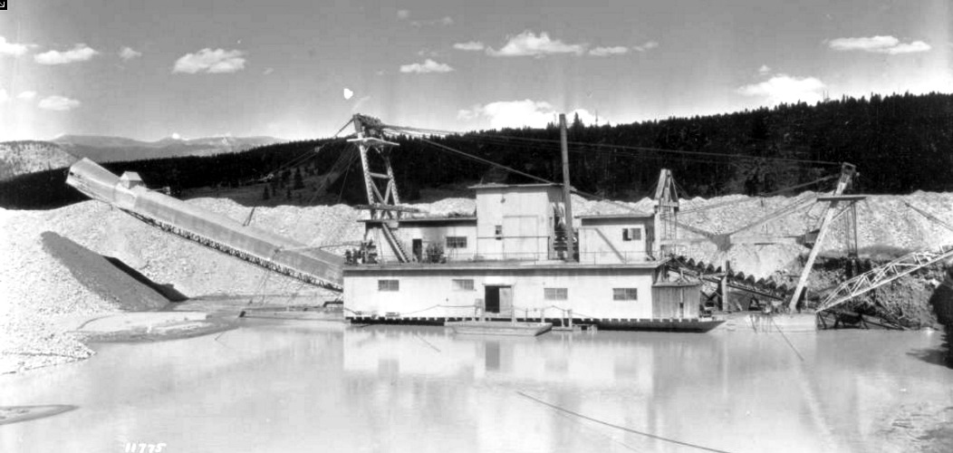 This photo is captioned as "Dillon Dredge, Public Service Co.. July 29, 1924", written on the print. Was there a dredge on the Blue River north of Dickey, or below (north of) Dillon? To me, this looks like one of the dredges on the Swan or Blue Rivers in the Breckenridge vicinity. Perhaps the photo is mislabeled. Anyone know? Any dredge experts out there? Darel, you're the "Along the Blue" guy; or maybe Roper knows. And then there is this: http://digital.denverlibrary.org/cdm/singleitem/collection/p15330coll22/id/14926/rec/2 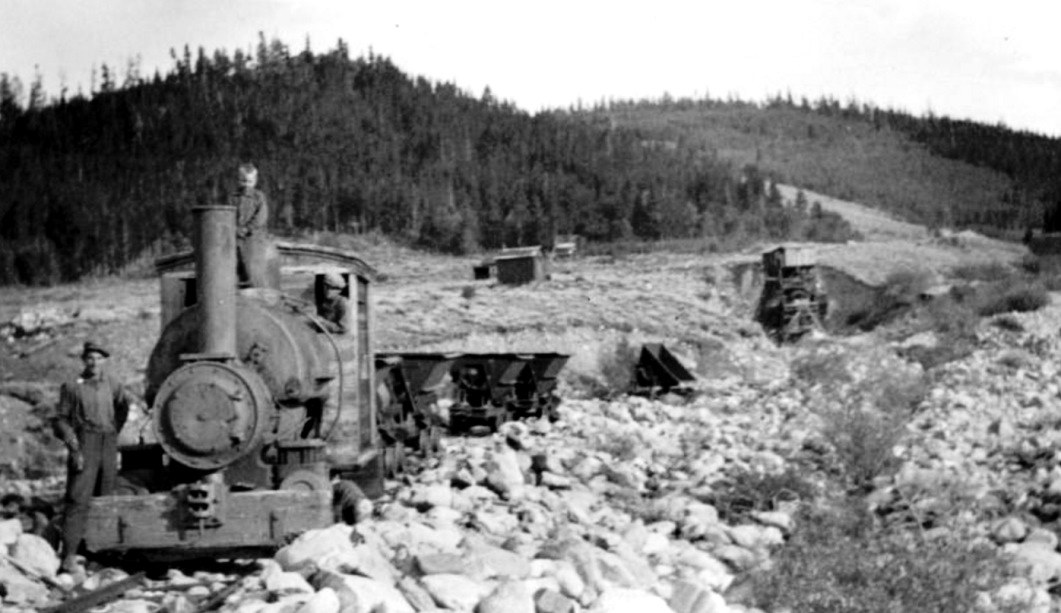 This photo is captioned: "An old mine in Summit county, near Dillon, Colo., July, 1925". Any ideas as to what this tram operation was and whether it was really near Dillon?
Jim Courtney
Poulsbo, WA |
Re: Dillon / Keystone Operations Revisited
|
In reply to this post by Jim Courtney
Jim, given the preponderance of mine props being loaded at Keystone, perhaps the loading platforms at Colligan are for the same purpose?
Can someone find a USGS map of Dillon and vicinity? Being born 'after the dam' I have never understood where Dillon was.
Keith Hayes
Leadville in Sn3 |
|
In reply to this post by Jim Courtney
I am not an expert on Dredges but I do not remember seeing the effects of their operation in that area. All the ones I have read about were a long ways away from Dillon.
There is nothing much in those photos that give a clue, does not look right for that area, but no way of being certain. I was there on Friday and the hills just looks too low Somebody who knows their dredges could hopefully say which one it is. |
Re: Dillon / Keystone Operations Revisited
The whole area was dredged from Breckenridge to Dillon. In recent years the Breckenridge area has been cleaned up. However, the last time I was in that area, the "damage" was still visible along highway north of the Dillon reservoir. Jimmy |
|
By 170?
Breck and South Park show very obvious traces, not so much Frisco etc. Frisco museum did not mention it, just never seen anything about operations along there. |
Re: Dillon / Keystone Operations Revisited
Along highway 9, south of Dillon reservoir. Sorry, got turned around, SOUTH of Dillon Reservoir. Jimmy |
Re: Dillon / Keystone Operations Revisited
|
According to Colorado School of Mines, that dredge operated north of Breck (but they don't say how far north).
http://hdl.handle.net/11124/8779 Here it is in the 1940s: 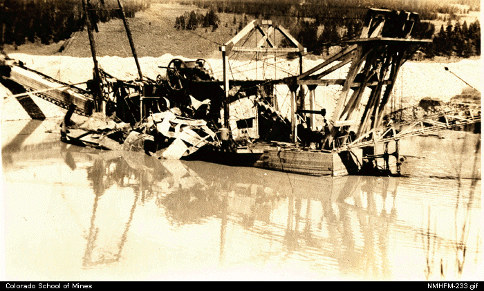 Cheers, Jeff. |
Re: Dillon / Keystone Operations Revisited -- Dillon Dredge.
|
This looks a lot like the "Dillon Dredge" that I posted above:
http://digital.denverlibrary.org/cdm/singleitem/collection/p15330coll22/id/32023/rec/8 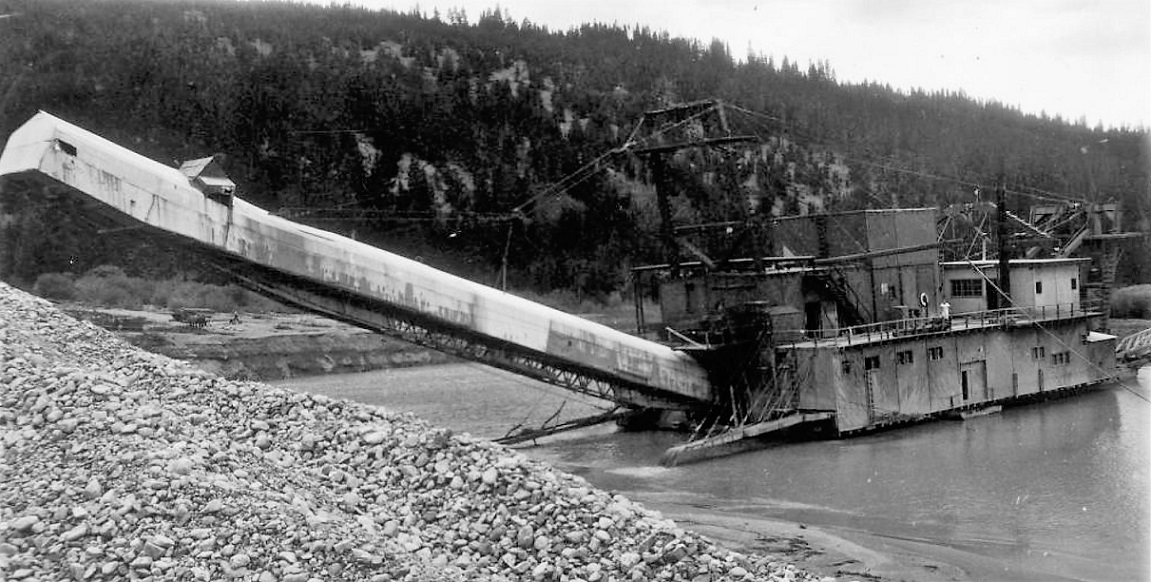 The DPL caption says: View of the Blue River Placer Mining Company (or Continental Mining Company) bucket-line dredging boat, in Breckenridge, Summit County, Colorado. Date is 1917-1938? There is also this view of a dredge on the Blue a couple of miles north of Breckenridge: http://digital.denverlibrary.org/cdm/singleitem/collection/p15330coll22/id/32025/rec/1 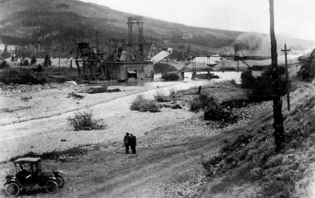 The DPL caption: Summary View of a Tonopah Placer Company bucket-line hydraulic gold dredge in the Blue River, at Breckenridge, Summit County, Colorado. "Two-Mile Bridge" is to one side; placer mine tailings are against hills, men and a parked car are in the foreground. Date July 28, 1918 This dredge looks to be bigger than the "Dillon Dredge" but smaller/not the same as the "Tiger Dredge" that ended up near the Breckenridge depot. So, it looks like dredges didn't make to the north of Dillon. Still, fascinating stuff, worthy of its own thread. 
Jim Courtney
Poulsbo, WA |
Re: Dillon / Keystone Operations Revisited
|
In reply to this post by Keith Hayes
Can someone find a USGS map of Dillon and vicinity? Being born 'after the dam' I have never understood where Dillon was.
Here you go, Keith: 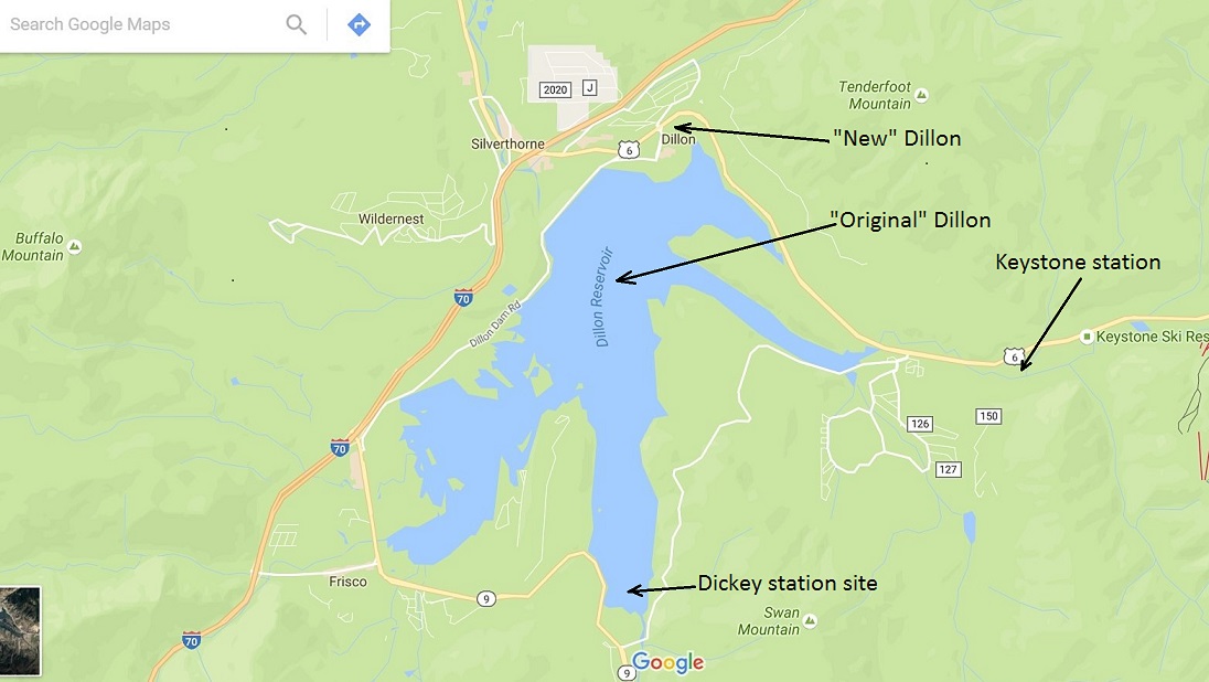
Jim Courtney
Poulsbo, WA |
Re: Dillon / Keystone Operations Revisited
|
This post was updated on .
Jim:
I was able to find a USGS topo from 1929 (Dillion Co, 1:62.5) that shows the contours roads and townsites before the lake. The location of the dam TOTALLY makes sense to me now. The map includes Dillon, Dickey, Frisco and Solitude/ Wheeler. Though the map is dated 1929 (based on 1927 data), it does not show the C&S or D&RGW ROW. There is also no indication that this was a map that was updated in, say, 1946 based on 1927-9 data. Even later maps often feature the abandoned ROW. But we really don't need the ROW. Now, if I was on the office computer, I could probably save the free PDF I downloaded to preview the map, along with a shaded area indicating the modern extant of the approximate shoreline. But that is for someone else to do. The USGS maps are in the public domain. It might be interesting to find the TOC maps and post them. Just an idea. Okay, take II: 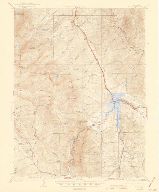 This is the Dillon quad from 1934. For reasons I don't understand, it has the ROW, which is extra handy. I grabbed the laptop and sketched in the water line just below the 9,000-foot contour for contemporary reference. It all makes so much more sense now. Enjoy. Okay, take III, a bit larger this time: 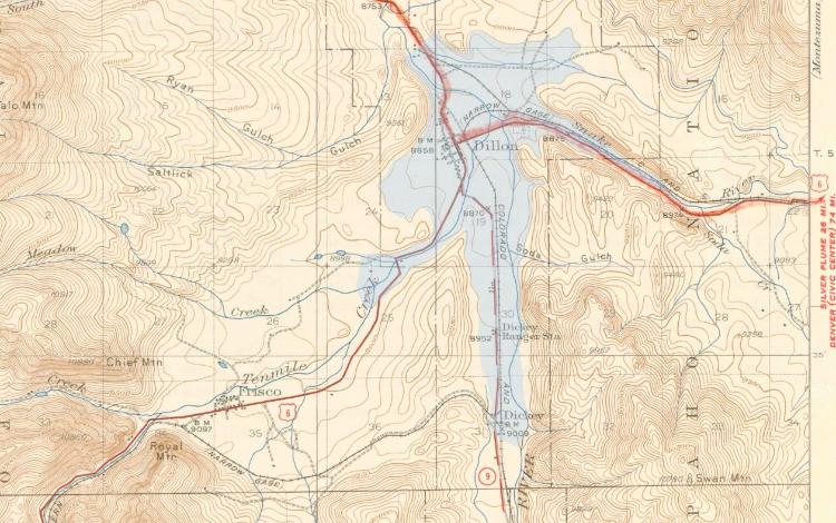
Keith Hayes
Leadville in Sn3 |
«
Return to C&Sng Discussion Forum
|
1 view|%1 views
| Free forum by Nabble | Edit this page |

