Braddocks, MP 113.29 -- Center of Gold Dredge Construction
12


12
Braddocks, MP 113.29 -- Center of Gold Dredge Construction
|
This post was updated on .
In Gerard's recent sawmill thread, our esteemed South Park, asked the question,
What was shipped at Braddocks, on the High Line above Breckenridge ? Was it just props ? I do remember an over-track crane/rack for loading and stacks of material waiting to be loaded. Seems to me, I recall the material was sawn, but I could be remembering it wrong. The more interesting question is not what was shipped out of Braddocks, but what was shipped into Braddocks. Braddocks was located 3.29 miles north of Breckenridge and had a 32 car siding, offset a ways from the mainline a bit. Prior to the turn of the century it was merely a passing siding between Dickey and Breckenridge, as this familiar photo illustrates: 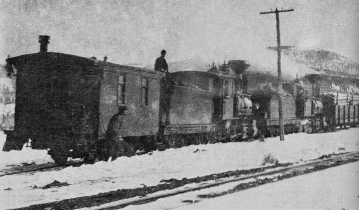
Kindig, et al., The Pictorial Supplement . . . A four engine Boreas bound freight is in "the hole" for the Leadville passenger train to pass. But beginning in 1898, Braddocks and Valdora (a 13-car spur one-half mile to the north, near the confluence of the Swan and Blue Rivers) became the staging areas for the construction of most of the gold dredges that were built between 1898 and 1918. All the timber for constructing the hull, deck and super structure of the vessel, most of it Oregon fir, was shipped in by the C&S and unloaded at Braddocks or Valdora and moved to the construction sites by team and wagon. That was followed by carloads of machinery from the east coast or California (depending on the builder) including the power plant (boilers in the early dredges, later large electric motors), the large bucket arms, the buckets themselves and parts for the spud poles (anchoring the dredge in it's pond) and the metal parts for the conveyors that deposited those ugly piles of gravel behind the slowly moving dredge. The materials for the first two (unsuccessful) Risdon dredges were likely unloaded at Braddocks in 1898 and hauled up to the Swan River for construction. The third Risdon dredge was constucted in April of 1899, with 18 carloads of machinery set out at Braddocks.* The fourth dredge was the first Bucyrus dredge constructed, also in 1899:  As far as materials for the 4th dredge, DL&G records indicate that 100,000 board feet of timber from Portland, Oregon, was shipped to Braddocks, one-fourth of the timbers were 40 to 50 feet long, requiring two flat cars to haul them from Denver. Some of the timbers were 24 inches square. In addition, 200 tons of machinery were shipped. The steel spud poles required shipping on 3 flat cars, one being an idler between the load bearing cars. In 1907, the Colorado Gold Dredging Co. simultaneously built the 6th and 7th dredges, Bucyrus products, on the lower Swan River, just above its joining with the Blue River. The spur at Valdora to the river building site was constructed then, so that materials on C&S freight cars could be delivered directly to the building site. Both dredges were electrically powered and cost $105,000 each to construct. Both began operation in May of 1908:  The 7th dredge (right) is beginning its journey up the Swan River. The 6th dredge (left) will work a short distance down the Swan, make a left turn at the Blue River and work the east bank of the Blue River all the way to Breckenridge, stopping near the depot in the 1920s. Some photos of the 6th dredge: 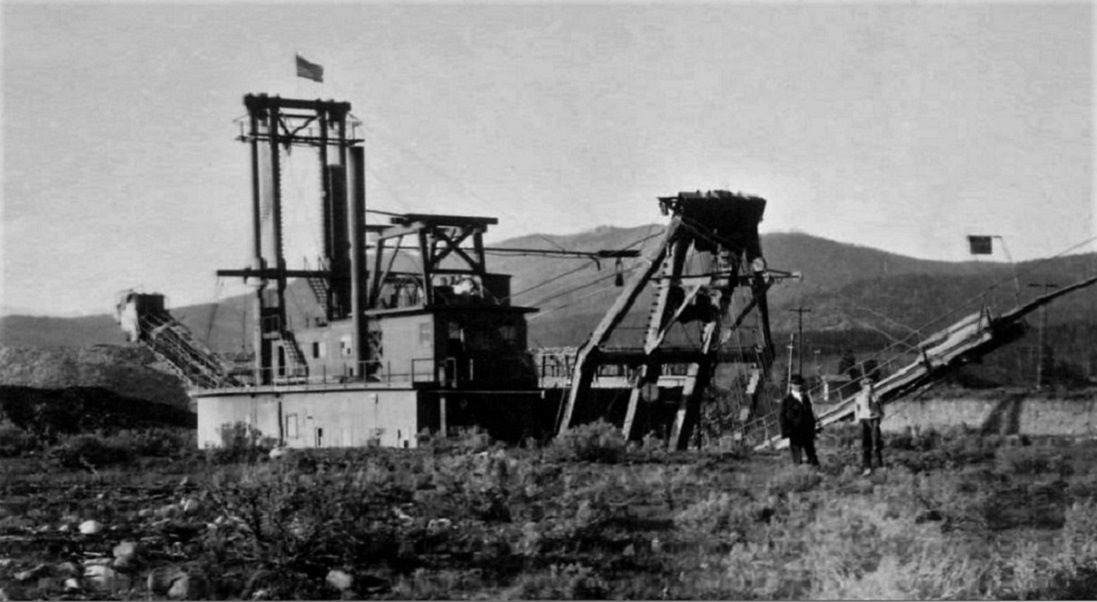 June, 1917. A WWI view, flying a battle flag.  July, 1918. At Two-Mile Bridge. 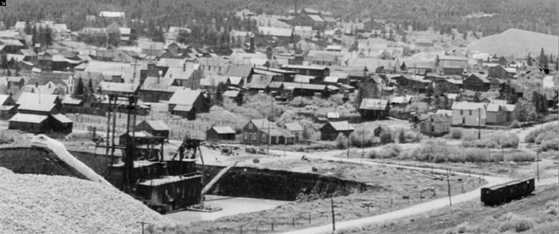 About 1925. Resting near the C&S depot and yards in Breckenridge. The dredge wouldn't begin working into Breckenridge proper until after 1938, when the railroad was gone., The busiest time period for Braddocks was 1917-1918 when it served as the staging area for construction of the 9th and last dredge, built by the Yuba Dredge Company of California for the Powder River Gold Dredging Co. The dredge pond was dug across the river from Braddocks siding, on the west bank of the Blue. A tent city of Californians was set up at Braddocks for the construction. The 97 bucket dredge was finally completed in April, 1918, a shortage of C&S railroad cars having delayed delivery of the large transformers for the power plant.** This is how the big dredge looked: 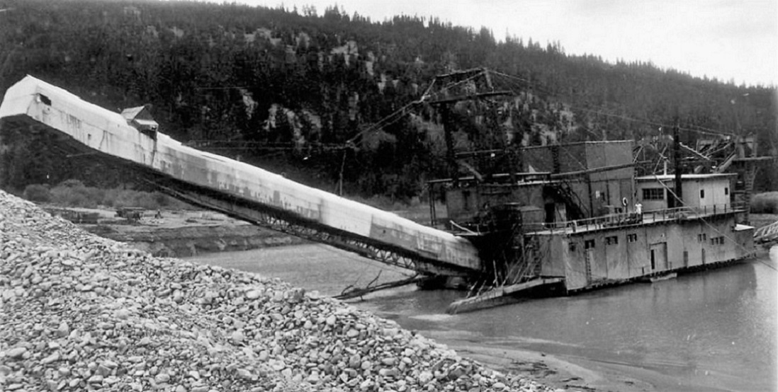 1922 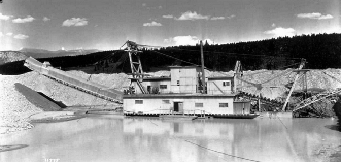 1924  1925 The Yuba dredge was likely the most successful of the Summit County gold dredges, from 1918 to 1938 it was in almost continual operation, under at least four owning companies. It made multiple round trips between Braddocks and the outskirts of Breckenridge, thoroughly chewing up the gravels of the west bank of the Blue River. During its 20 year carrier, it burned to the waterline once and sank in its own pond on multiple occasions, always re-floated or rebuilt. Several employees were crushed, electrocuted or drowned in the dredge pond. When operations ceased in 1938, the dredge was dismantled, the machinery and buckets installed in a new dredge hull near Fairplay. This shipment was likely by truck over Hoosier Pass, as the C&S was gone by then. After 1918, Braddocks reverted to being a siding for loading mine props and sawn timbers / ties, the Yuba dredge occasionally passing by, on its back and forth journeys to Breckenridge:  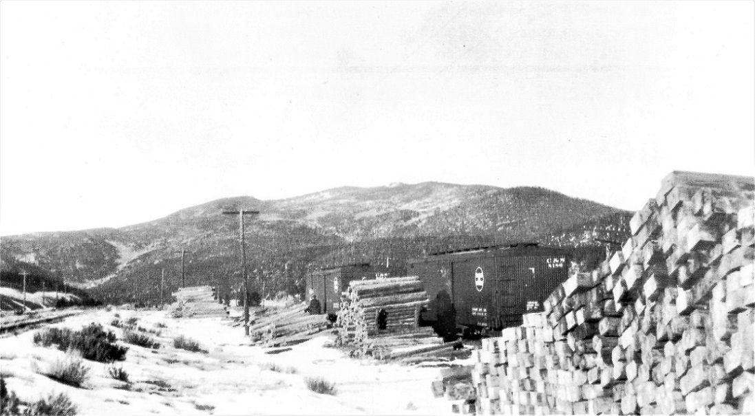 Both photos dated November, 1928. Whately Collection in the Klingers" C&S Platte Canon Memories . . . It isn't clear whether the wood crane that straddled the siding was installed during the Yuba Dredge construction or was a later addition for the folks shipping timbers. ______________________________________________ *The source for the dredge construction information and photos was Ellis, Erl H., The Gold Dredging Boats Around Breckenridge, Colorado, Johnson Publishing, Boulder, CO, 1967. I was lucky to acquire a signed copy many years ago. **1917-1918 was a time of intense activity in the Climax area. Three companies sought to develop the molybdenum deposits there for the WWI war effort. In addition to the first mill at Climax, a competing mill was built just to the north of Fremont Pass. The C&S was quiet busy delivering hundreds of carloads of construction materials and machinery to the two mill sites, hence the freight car shortage. When the war ended in 1918, both mills shut down. The Climax mill was the only one to reopen in 1924, as demand for moly again began to grow for industrial uses.
Jim Courtney
Poulsbo, WA |
|
Thank's Jim,
I had a image in my head of the Gantry SthP'k was referring to but never got as far as the Klinger books before bed last night. Since those volumes are of "recent" addition, my brain has not yet fully added them into any search equation, unlike the other books of 30+ years I have memorised.
UpSideDownC
in New Zealand |
|
That is the imagae I had in my head, ... big stacks of sawn timbers of some
sort, and the rail-straddling crane. For some reason, I was thinking the siding was upgrade from Breckenridge, on the backside of Nigger Hill.
"Duty above all else except Honor"
|
|
This post was updated on .
In reply to this post by Chris Walker
Chris,
As I get older, I can remember a specific photo, but have increasing difficulty remembering which book said photo is in. So, I've been gradually scanning photos into my computer, using these threads as an impetus to keep doing it. Have you noticed that the photos in the older books are beginning to fade? Especially all the wonderful photos in The Pictorial Supplement ? By scanning them into my computer, I can play with the contrast and light to restore them somewhat to their original appearance. And organizing them by decade and location has made them easier to find. I've been meaning to post some stuff about the gold dredges, "The Blue River Navy", for some time--South Park's question seemed a good excuse. BTW, Chris, did you know that gold dredging was a Kiwi invention? First dredge on the Clutha River, near Alexandra, an early spoon dredge in 1863 slowly developed into a "steam bucket and ladder dredge" by 1882. By 1899 there were 171 dredging companies in Otaga Province alone. In 1895 a New Zealander named Robert H. Postlethwaite arrived in California and went to work for the Risdon Iron Works, patenting many of the New Zealand dredge concepts in this country, The first Risdon dredge built was on the Yuba River, and was the first successful gold dredge in California. So, maybe New Zealand is indirectly responsible for all those ugly piles of gravel north of Breckenridege . . . 
Jim Courtney
Poulsbo, WA |
|
In reply to this post by Jim Courtney
There are plenty of references to sawmills, also plenty of reference to spurs being constructed to meet customers requirements, I had not appreciated until recently quite how common this was. Policy probably changed over the years but certainly at times as long as the business case was made and the customer covered the cost then the spur would be installed and the customer would receive a rebate on shipments up to the install cost.
I can not recollect a sawmill having a spur constructed, a clue may be the reference to bringing in wood for the construction of the Dredge from out of state. There is very little left of the dredging north of Breck, I would imagine most visitors are not aware of this part of Breck's history. |
|
" ... ugly piles of gravel ... "
As piles of gravel go, what do the good looking ones look like ? .... asking for a friend. 
"Duty above all else except Honor"
|
|
Well, South Park,
I consider this to be the most attractive pile of gravel on the entire C&S:  The gravel removed from the Gold Pan pit -- it's tall, symmetric, slightly taller at the far end. Nicely dwarfs a C&S locomotive. Would make a nice scenic divider on a model railroad representation of Breckenridge. Chris might opine that the gravel piles at the Argo Tunnel in Idaho Springs, are the most attractive C&S gravel piles. Anyone else have a favorite gravel pile?? 
Jim Courtney
Poulsbo, WA |
|
I had no idea of the extent of these operations! What a fantastic traffic generator and scenic element. The only model of a dredge I've seen in the past was on Brian Pate's exquisite HOn3 layout set in the area around Dawson City. Sure would be a show stopper on a model of Breckenridge!
Dave Eggleston
Seattle, WA |
Re: Braddocks, MP 113.29 -- More Dredge Info
|
This post was updated on .
Yep, the Breckenridge area was unique in the diversity of the various mining operations. Placer mining, hard rock mining, mills, smelters and dredges.
For those who would like to dredge up more information on these gold mining oddities, here is additional info from Sandra F. Pritchard's Roadside Summit, The Human Landscape (1992). 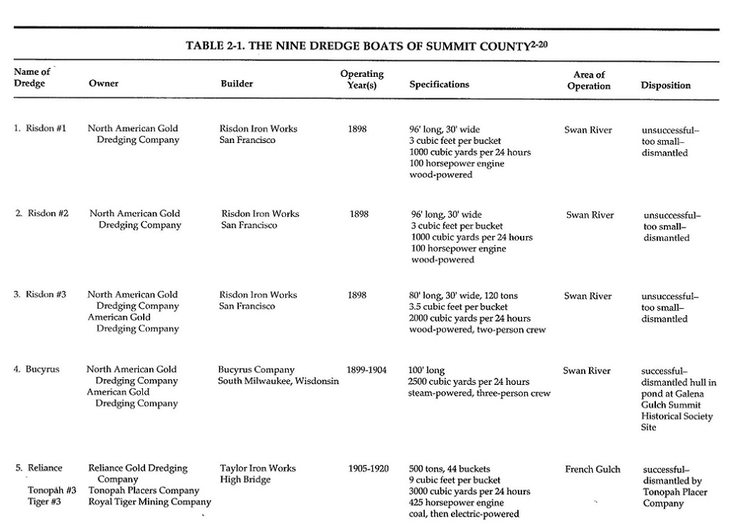 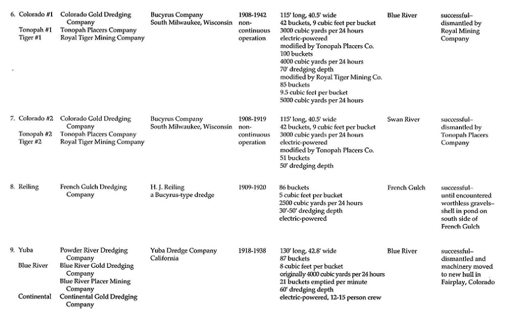 A map of the location of operations of the various dredges and the placer claims that they worked. 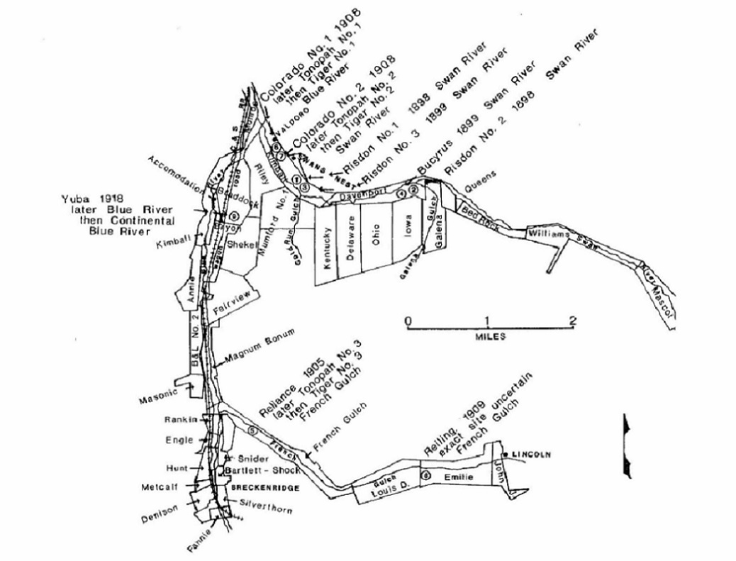 There were two other gold dredges that were built to work up French Gulch, just a bit north of Breckenridge. Their construction had nothing to do with Braddocks. Materials were likely set out in the Breckenridge yards and moved by team and wagon up to the building sites on French Gulch. The fifth dredge AKA the "Reliance dredge", built in 1905:  1906 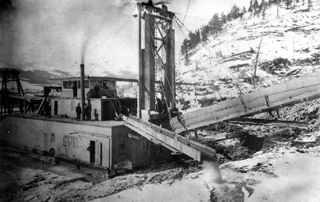 1908 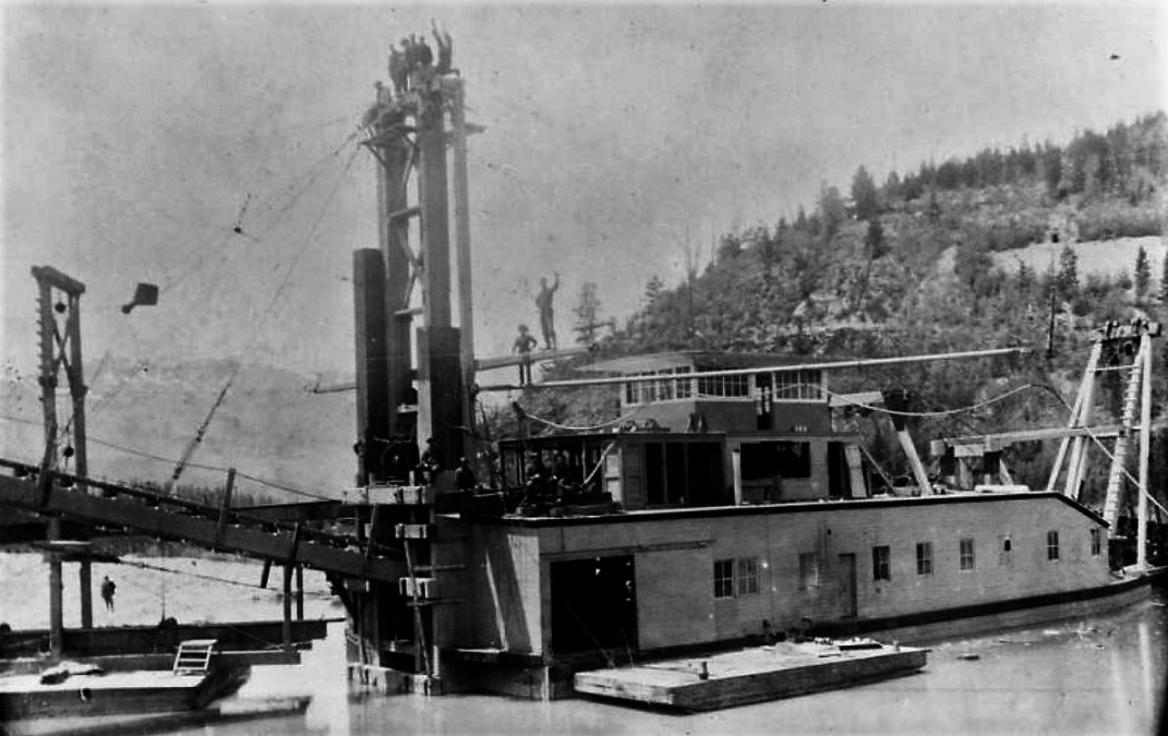 1910 The eighth dredge AKA "Reiling dredge" was built in 1909 and worked upper French Gulch: 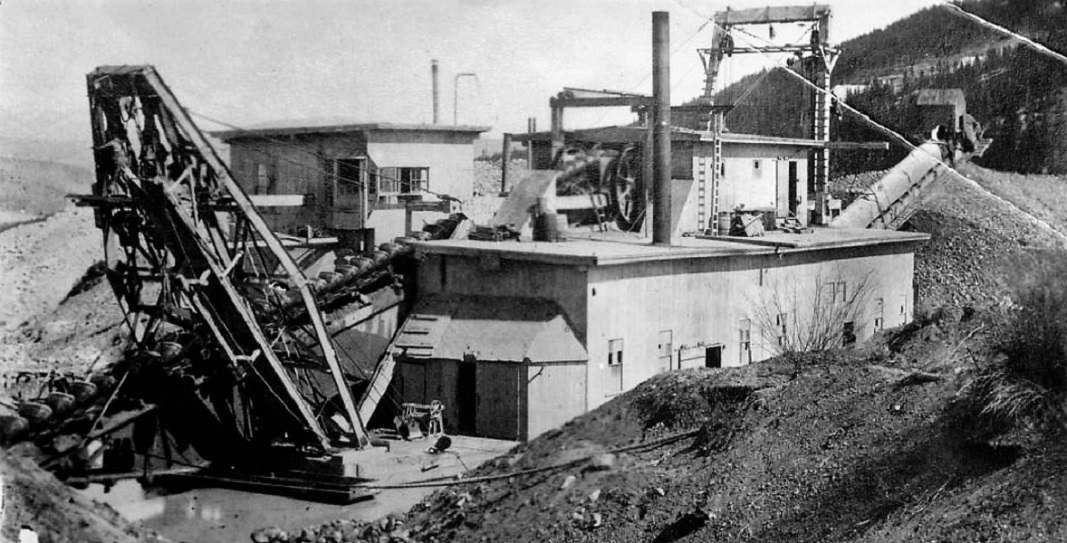 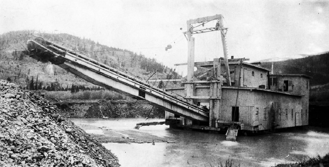 Two photos from 1920. Just like the failed Gold Pan Pit, the early dredges were financial failures due to a basic misconception of the owners and builders. At the turn of the century it was believed that the gold in the alluvial gravel beds around Breckenridge was evenly distributed in the gravel "from tree roots to bedrock". In fact, over the millennia, the gold had worked its way down the gravels to near bedrock. The only financially successful dredges were the big boats, with long bucket arms that could chew down to that depth. For model building purposes, only the 6th and 9th dredges worked the Blue River and were the only two boats anywhere near the C&S railroad tracks. For those interested in how the dredge was rigged / operated: 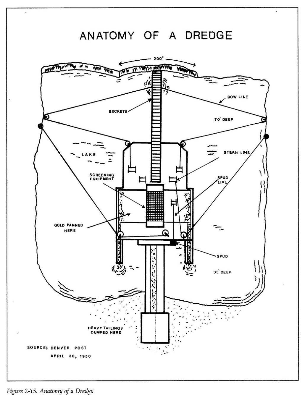
Jim Courtney
Poulsbo, WA |
Re: Braddocks, MP 113.29 -- More Dredge Info
|
Which boats made the better looking gravel piles ? For the cost of a dredge,
one would think the buyer would specify one that made attractive gravel piles ! 
"Duty above all else except Honor"
|
Re: Braddocks, MP 113.29 -- More Dredge Info
|
What about a beautiful city dump?Or exquisite poop?
|
Re: Braddocks, MP 113.29 -- Center of Gold Dredge Construction
|
In reply to this post by Jim Courtney
Panoramic image from the Library of Congress which in 1917 shows the area near French Gulch between Breckenridge and Braddocks that soon will be worked. The highway pin truss must be what has been referred to as "Two Mile Bridge", with the railroad's trestle over the Blue River beyond. At the far right looks like there is possibly 2 stiff leg derricks. I wonder if these derricks were used for assembling and dismantling the dredges in the vicinity?
What a backdrop! 
|
Re: Braddocks, MP 113.29 -- Center of Gold Dredge Construction
|
Is Breckenridge to the left in that panorama shot ?
"Duty above all else except Honor"
|
Re: Braddocks, MP 113.29 -- More Dredge Info
|
In reply to this post by Robert McFarland
"What about a beautiful city dump? Or exquisite poop?"
Ask anyone familiar with a stout tangle with constipation, and they can tell you all about an exquisite poop. Liken it to a clearing a train wreck and now all the backed up trains can get on to their destinations. The feeling of the Roadmaster would be nothing short of exquisite. 
"Duty above all else except Honor"
|
Re: Re: Braddocks, MP 113.29 -- Center of Gold Dredge Construction
|
Seriously Robert !
Some of your posts of late have been really out of whack, is everything OK? Before this thread makes a turn for the worst with more talk of constipation...  Jeff, what you see is the Hydraulic headpipe stand and a Stiff-leg Derrick used to hoist out the huge stones and boulders encountered, these were part of a pre-Dredging placer operation as can be seen in this view.https://digital.denverlibrary.org/digital/collection/p15330coll22/id/32025 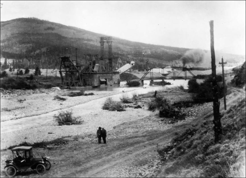  the headpipe stand and stone boat, but at the Goldpan pit https://digital.denverlibrary.org/digital/collection/p15330coll22/id/26450 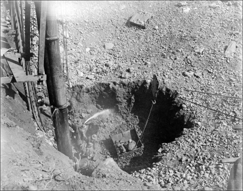 Yes Jim, I'm well aware of the NZ contribution of the Bucket Dredge to the world, want me to tell you about all the others?  Chris might opine that the gravel piles at the Argo Tunnel in Idaho Springs, are the most attractive C&S gravel piles. Well maybe not since the Argo dump was broken metamorphic rock waste and the gravel piles along the Blue are aluvial, big difference there, almost like Proctology and Gynecology to put the context into your arena.  ... ... ... ...
UpSideDownC
in New Zealand |
Re: Re: Braddocks, MP 113.29 -- Center of Gold Dredge Construction
|
I've always found these two views of the Two Mile Bridge area to be fascinating.
At this point, about MP 112.0, the C&S tracks crossed from the east bank of the Blue to the west bank for the remainder of its journey to Breckenridge. According to the 1918 ICC valuation map, this crossing of the Blue was on a 9-span low pile trestle. Just a tad upstream, the county road between Breck and Dickey moved from the west bank to east bank, on the iron pin-connected truss bridge. The 6th dredge working south, upstream, toward Breckenridge, on the east bank of the Blue, had to cross both the railroad and the county road at this point. In the DPL photo that Chris re-posted, the dredge has already chewed through the railroad grade and moved on south, the railroad grade refilled, graded and track relayed. The dredge has cut through county road to the left of the bridge abutment and move a bit south, but the fill leading up to the bridge abutment hasn't been repaired yet. As to the "stiff-leg" derricks in the "panorama" photo, are we sure that isn't the 6th dredge just entering the area at the right frame?  The vertical elements suggest to me the rigging of the dredge -- on the left the derrick that raised and lowered the bucket arm, the one on the right, the rigging of the two spud poles, with the dredge superstructure in between. Compare the vertical rigging of the clear photo of the dredge in the DPL photo. Chris's explanation also makes sense. I've never been sure . . . 
Jim Courtney
Poulsbo, WA |
Re: Re: Braddocks, MP 113.29 -- Center of Gold Dredge Construction
|
In reply to this post by Chris Walker
There's no such thing as an attractive gravel pile.Look at all the landscapes that have been ruined by dredging and hydraulic mining.What about what recently happened when hasmat that had been dammed up in SW Colorado leaked out and polluted local rivers?As for me I'm feeling fine thank you.
|
Re: Re: Braddocks, MP 113.29 -- Center of Gold Dredge Construction
|
In reply to this post by Jim Courtney
I don't agree with your thoughts that the Railroad has been relaid or relocated, Jim.
Everything sits in relation to the other features in both photos, btw Jeff's LibofCongress photo is here https://www.loc.gov/resource/pan.6a02629/ To me the Dredge has only made one run in this location, run alongside the grade, stopped piling up the tailings at the C&S Trestle to allow the Blue to continue downstream, then cut through the County road approach to the road Bridge, but still staying East of the RR grade. You can see the disparity in the pile sizes where the stacker has been moved depositing tailings before starting a new pile thus keeping the river channel open. A Dredge makes its own pond, can and did work in open ground without a river channel. The Derrick stacker piles are also of lighter colour and shape from the Dredge tailings which are not coned. All the vertical elements in both photos are still in place, relative to the placement of those coned piles. 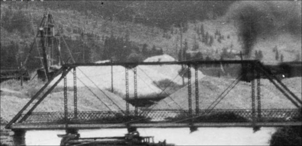
UpSideDownC
in New Zealand |
Re: Re: Braddocks, MP 113.29 -- Center of Gold Dredge Construction
|
Do we really need to talk about coned piles ?

"Duty above all else except Honor"
|
Re: Re: Braddocks, MP 113.29 -- Center of Gold Dredge Construction
|
This post was updated on .
In reply to this post by Chris Walker
I suspect you are right, Chris.
I think that I misconstrued a couple of passages in Ellis's book: "Early in March of 1917 there was a fire in the workshops of Dredge No. 1 (the sixth dredge). In the summer there was again a problem of dredging where the rails lay and so the tracks were moved for temporary purposes. It appears that the land of the Placers company on the east side extended further south. Trains returned to the regular route about mid September." . . . "At the end of the year Dredge No. 1 was working up the Blue River, on the east side of the tracks, and approaching the Two-mile bridge . . . the boat would be on the Magnum Bonner Placer early next season." and "In July (1918) the No. 1 dredge had reached the Two-mile bridge and found bed rock only twelve feet below the surface . . . later in the year the dredge passed Two-mile bridge." "Dredge No. 1 started up April 11, 1919 . . .To have the best advantage is working the Magnum Bonner Placer it was necessary to move about a mile of the railroad tracks (from the Breckenridge Cemetery north) . . . and this was done in the summer." No where could I find a reference of the dredge actually crossing the railroad tracks, and it appears that it always worked on the east side of the tracks. I'm interpreting this as the various placer claims were in place long before the arrival of both the railroad and the dredge. The railroad was given a right of way across the placer claims. The dredge worked placer claims both owned by the company (in 1916-1919 Tonopah Placers Co.) and contracted to work claims owned by others, who received a share of the profits. If the railroad grade / tracks was in the way of dredging, a temporary "shoo-fly" was built to allow the dredge to work the gravels under the right of way, as in the first instance. Or, the tracks might be relocated altogether, as in the second instance, to allow the dredge room to work. I wonder who paid for the track relocation, both temporary or permanent -- the railroad or Tonopah Placers Co.??  U.S.G.S. photo in Ellis's book. The photo is from about 1920-1921. The sixth dredge is working south between Two-Mile Bridge and Breckenridge, opposite Barton Gulch. The C&S tracks are in the distance, on the far (west) bank of the Blue River. I wondered if the grade in the foreground was the original C&S grade, with the stacks of what look like ties. But the 1918 Valuation map, compiled when all this happened, shows the tracks to be pretty much a tangent from MP 112 at the Two-mile bridge, south to the Breckenridge yard throat, always on the west side of the Blue River. The Magnum Bonner placer is shown on the maps to occupy both the east and west banks of the Blue. No where on the maps are there any notations of "shoo-flys" or relocated grade.
Jim Courtney
Poulsbo, WA |
«
Return to C&Sng Discussion Forum
|
1 view|%1 views
| Free forum by Nabble | Edit this page |

