Loading... |
Reply to author |
Edit post |
Move post |
Delete this post |
Delete this post and replies |
Change post date |
Print post |
Permalink |
Raw mail |
I saw photo today that was new to me, at the History Colorado website. This image's Photo ID is 2022.57.12651. The photo caption given is, "Ore Train Gilpin County: Gilpin Tramway Engine No. 4 with coal cars in winter." This is located here.
![]() So, where was this image taken? My first guess, could be of the train is backing down the mainline, on the south slope of Gunnell Hill? Note the mine near upper right - could that be the Prize Mine? If it is, the buildings in the upper left background might be the “Dogtown” area in lower Nevadaville. Any other thoughts? Opinions? Seeing this photo was very fun for me, as unfamiliar images of the Gilpin Tram don't come up very often! Keith
Keith Pashina
Narrow-minded in Arizona |
Loading... |
Reply to author |
Edit post |
Move post |
Delete this post |
Delete this post and replies |
Change post date |
Print post |
Permalink |
Raw mail |
Keith your guess is right and that is the Prize mine.
Great find GRUMPY |
Loading... |
Reply to author |
Edit post |
Move post |
Delete this post |
Delete this post and replies |
Change post date |
Print post |
Permalink |
Raw mail |
Thanks Grumpy for help with identifying the location of the photo.
For reference, here is a partial USGS map from 1917, showing the vantage point from where this photo was taken: ![]() And here is about the same area as it looks this century. I saw some recent Facebook postings that seem to show that mine has partially collapsed from recent snowfalls. ![]() Keith
Keith Pashina
Narrow-minded in Arizona |
Loading... |
Reply to author |
Edit post |
Move post |
Delete this post |
Delete this post and replies |
Change post date |
Print post |
Permalink |
Raw mail |
This post was updated on Dec 22, 2024; 4:58am.
I'm a bit late to the party I see, Keith has been MIA.
![]() On your Topo: the Prize is 4 arrowed (as per USGS PP94) see Plate 06. Note: the Argo Tunnel passes below slightly to the West(the heavy black vertical line on your Topo segment). I had another one saved for you; unable to cross-check on your Freerails to see if you had already discovered it. What I think is GT Coalcar #5(reno.14) at the Hawley-Gardner mine. EDIT: that's the First National Kansas mine; I was going off Sundances Gilpin book, pg122/123 for the id, and I read it as the number in brackets after the name; looks like I was wrong; the number in brackets comes first. ![]()
UpSideDownC
in New Zealand |
Loading... |
Reply to author |
Edit post |
Move post |
Delete this post |
Delete this post and replies |
Change post date |
Print post |
Permalink |
Raw mail |
In reply to this post by Keith Pashina
![]() Going through my railroad un filed papers and came across this photo. Don't know where came from or maybe it's been posted before GRUMPY |
Loading... |
Reply to author |
Edit post |
Move post |
Delete this post |
Delete this post and replies |
Change post date |
Print post |
Permalink |
Raw mail |
In reply to this post by Keith Pashina
Keith, great photos. So, you still can ID snow after the move. The before and now photos always are great.
Monte
Mlp
|
Loading... |
Reply to author |
Edit post |
Move post |
Delete this post |
Delete this post and replies |
Change post date |
Print post |
Permalink |
Raw mail |
Grumpy,
That's a nice view of the Prize Mine. I wonder if a higher resolution copy is available somewhere? There could be some interesting details visible at the mines on Quartz Hill in the background. Keith
Keith Pashina
Narrow-minded in Arizona |
Loading... |
Reply to author |
Edit post |
Move post |
Delete this post |
Delete this post and replies |
Change post date |
Print post |
Permalink |
Raw mail |
Keith,
Originally posted on here http://www.gilpintram.com/prize.html I'm not exactly sure, but I have a feeling this was a Lachlan McLean image.... ![]()
UpSideDownC
in New Zealand |
Loading... |
Reply to author |
Edit post |
Move post |
Delete this post |
Delete this post and replies |
Change post date |
Print post |
Permalink |
Raw mail |
Chris - I've seen that image before - there used to be a website, "Mining Bureau", where they sold a CD of several images. By the time I discovered the site, they were no longer selling them. I haven't found the same photo on other online collections. Maybe it'll turn up somewhere, sometime?
Keith
Keith Pashina
Narrow-minded in Arizona |
Loading... |
Reply to author |
Edit post |
Move post |
Delete this post |
Delete this post and replies |
Change post date |
Print post |
Permalink |
Raw mail |
The Gilpin Tram train photo we’ve been discussing was taken on the south slope of Gunnell Hill, along the Gilpin Tram main line. The train pictured appears to be backing down from mines further up the line, perhaps one of the mines on Gunnell Hill, or further up the line .
There was a runaround track and wye a short distance ahead of the train, so maybe they turned the shay before descending Chase Gulch. The elevation where the train is sitting is about 8,950 foot elevation, and the train will need to descend Winnebago Hill and Chase Gulch to reach the Black Hawk “roundhouse”, which is at about 8,225 foot elevation. The train will descend 725 feet in about 3.63 miles (using the C&S official mileage chart dated 7-01-1914). This equates to about an average 3.7% grade – no wonder the tram used shays! Chase Gulch is an interesting and very scenic part of the Gilpin Tram’s route, and I think well worth while to take a closer look. So, let’s expand on this post, and take a look at the mainline and the route through Chase Gulch, and the various sights along the way. For some background, there have some previous relevant posts dealing with Gilpin Tram track and facilities Black Hawk: The Gilpin Tram in Black Hawk: The Gilpin Tram in Black Hawk And Chris Walker’s thread on the Gilpin Tram’s Engine House in Black Hawk: Speculations on the Gilpin Tramway at the Black Hawk Roundhouse
Keith Pashina
Narrow-minded in Arizona |
Loading... |
Reply to author |
Edit post |
Move post |
Delete this post |
Delete this post and replies |
Change post date |
Print post |
Permalink |
Raw mail |
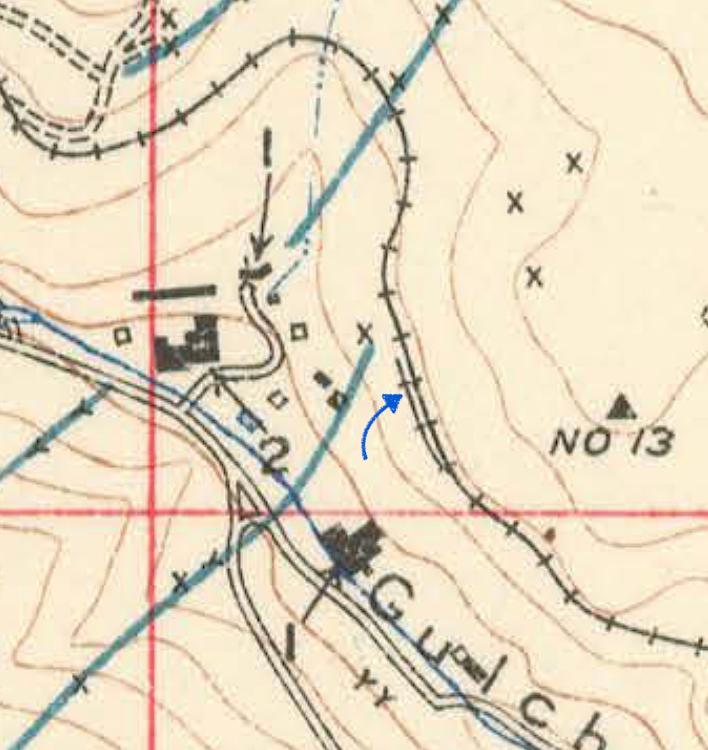
![]() ![]() This map shows the area we're starting from - the engine house (or roundhouse as the tram like to call it) and yards are nestled down along the North Branch of Clear Creek, and the mainline takes off to the lower right, in a general westward direction to reach the mines. The railroad and Clear Creek, along with a wagon road, are closely intertwined at this point. 
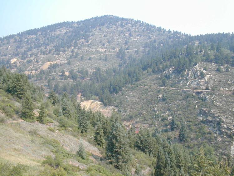
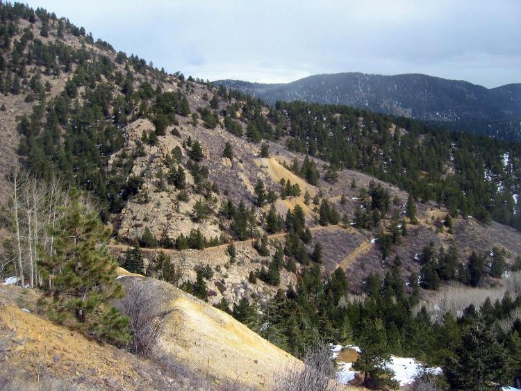
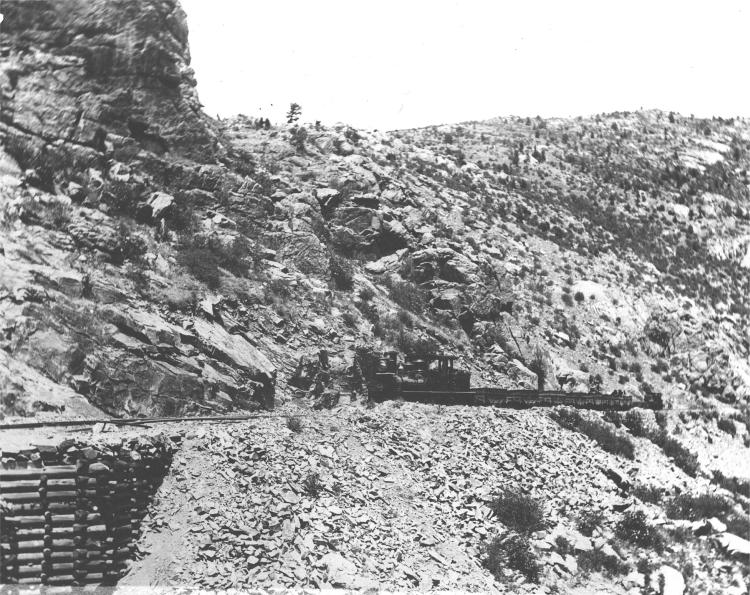
Chase Gulch was a major operational challenge for the Tram. The grade was about 3% to 4% throughout, and had numerous sharp curves. Photos published in previous books on the Gilpin Tram show double-headed and triple-headed trains of empties and loaded coal cars blasting up the grade. 
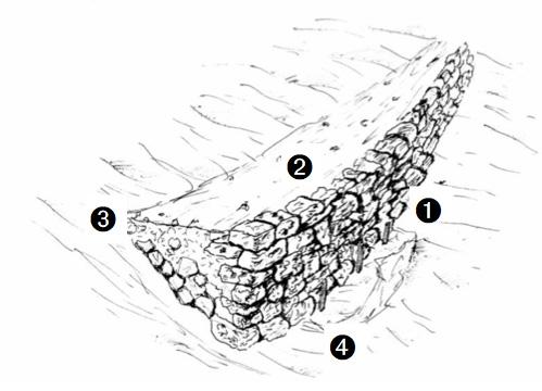
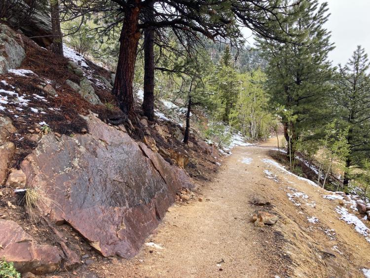
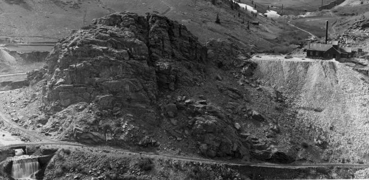
Chase Gulch is a rugged and narrow gulch with steep, rocky sides. The Gilpin Tram negotiated the gulch by snaking around major rock outcroppings, and building a lot of the right of way on narrow ledges supported on stone walls. Few sections could be built in straight or in easy-to-dig soil. ![]() 
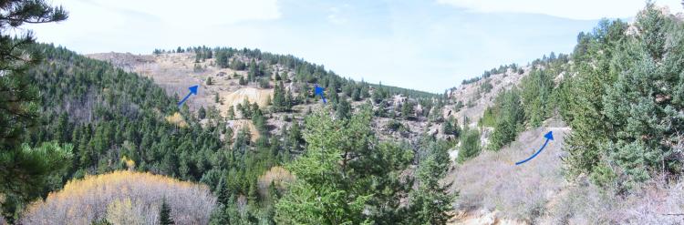
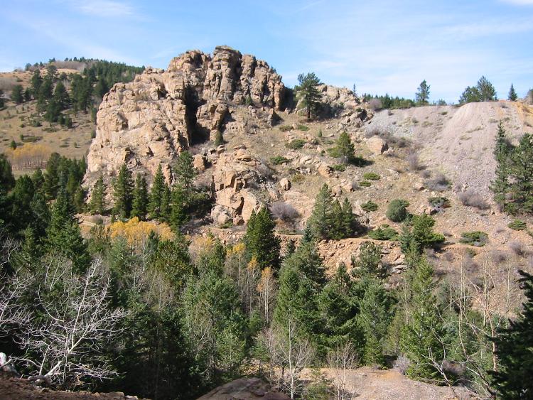
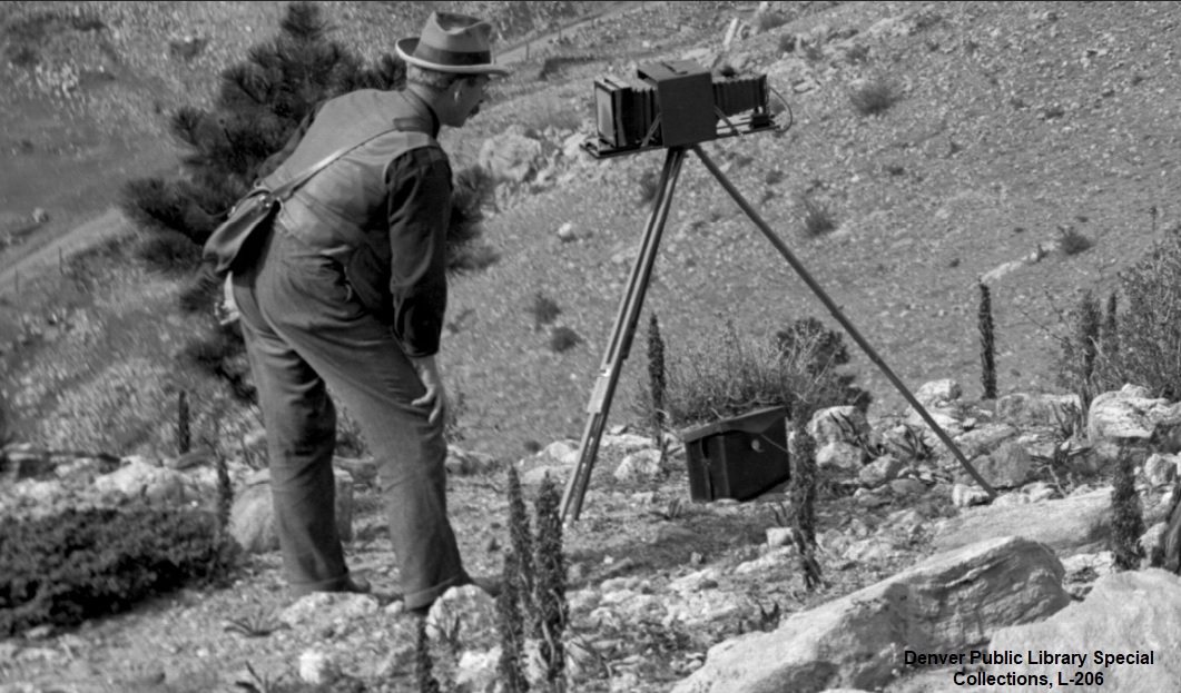
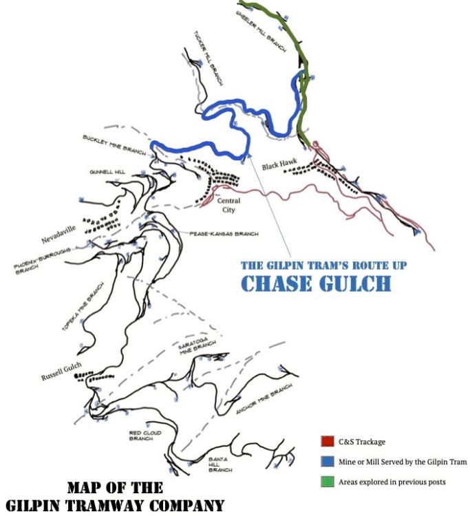
Here, our own website owner and moderator, Darel Leedy, is studying where the start of the switchback to the Hidden Treasure Mill (dashed arrow) diverges from the main line (solid arrow). Photo taken on a cold November day in 2000. ![]() 
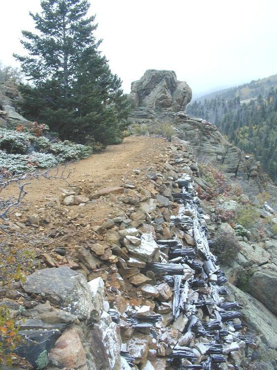
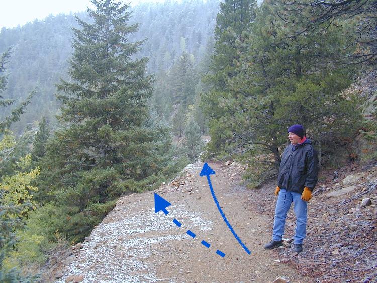
The grade is built on a steep hill side most of the way, and is a combination of minimal grading of the dirt and rock, and stone retaining walls. Here Gilpin Tram experts Dan Abbott, Chris Walker, and Joe Crea are hiking the grade in 2001. ![]() 
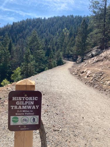
A few years ago, the local government rebuilt the grade for hikers and mountain bikers, so the old grade is very easy to explore. The trail head and parking lot are located about where the Gilpin Tram’s stone warming house was located. After climbing the east slope of Maryland Mountain, the grade takes a sharp turn to the west, about where the Smith Hill Road crossed the grade. 
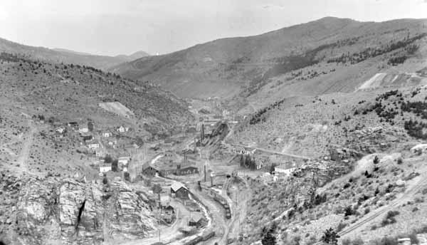
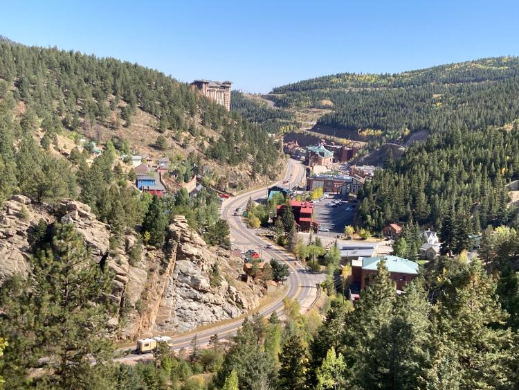
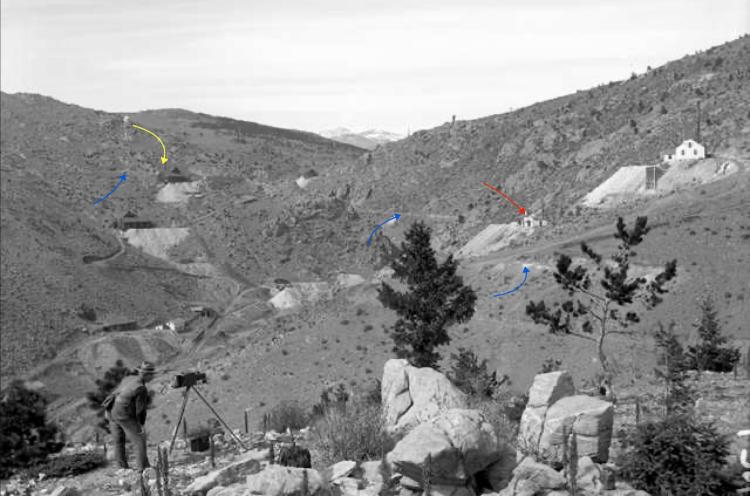
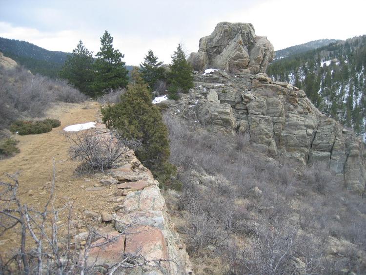
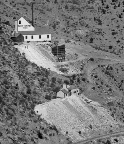
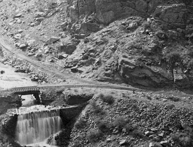
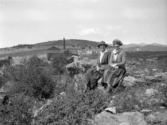
This location was photographed a few times in Gilpin Tram days, and was located more or less above the Polar Star Mill down below, in Black Hawk. ![]() 
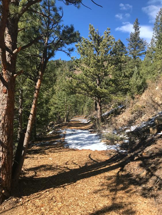
After leaving the switchback spur, the grade climbs along the east slope of Maryland Mountain. Many parts are graded such as shown here. ![]() 
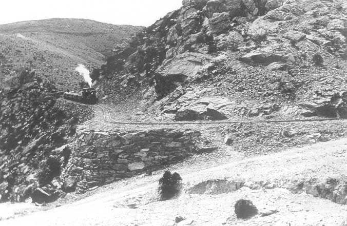
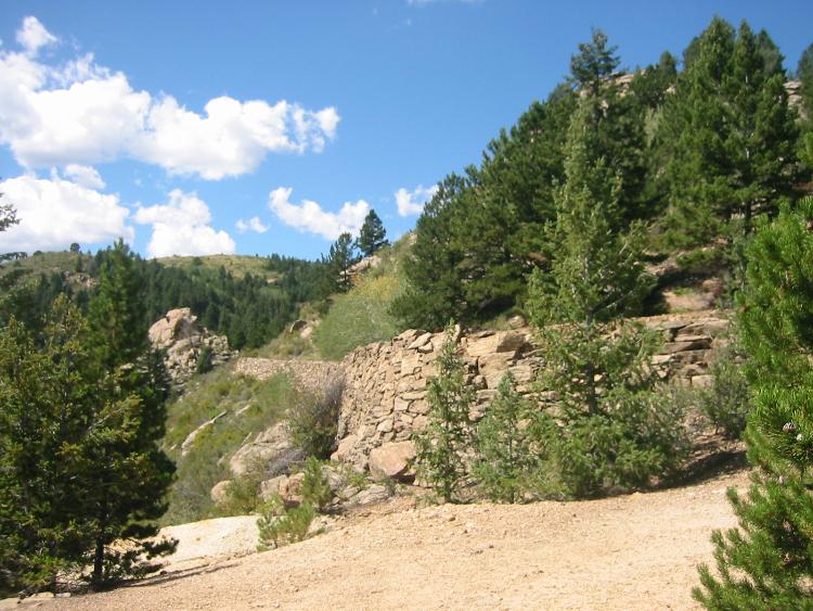
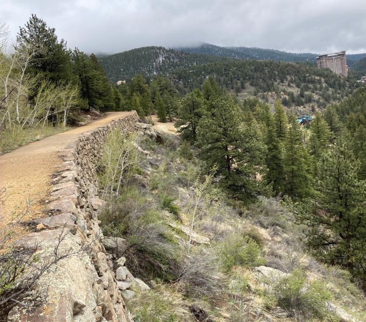
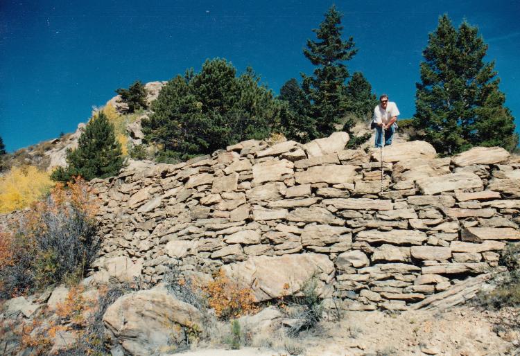
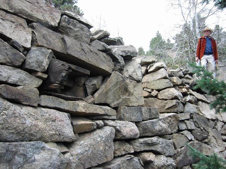
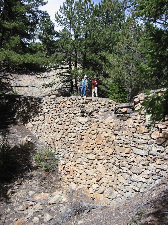
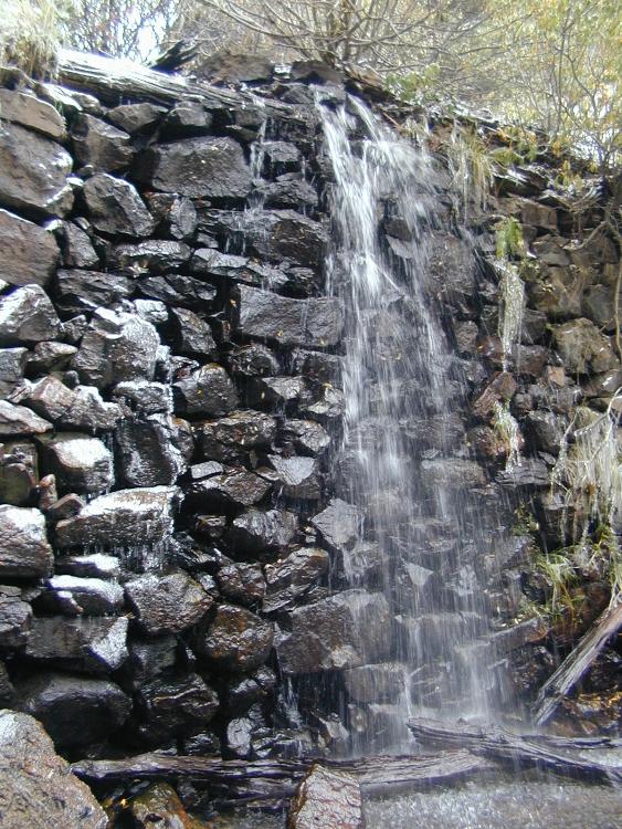
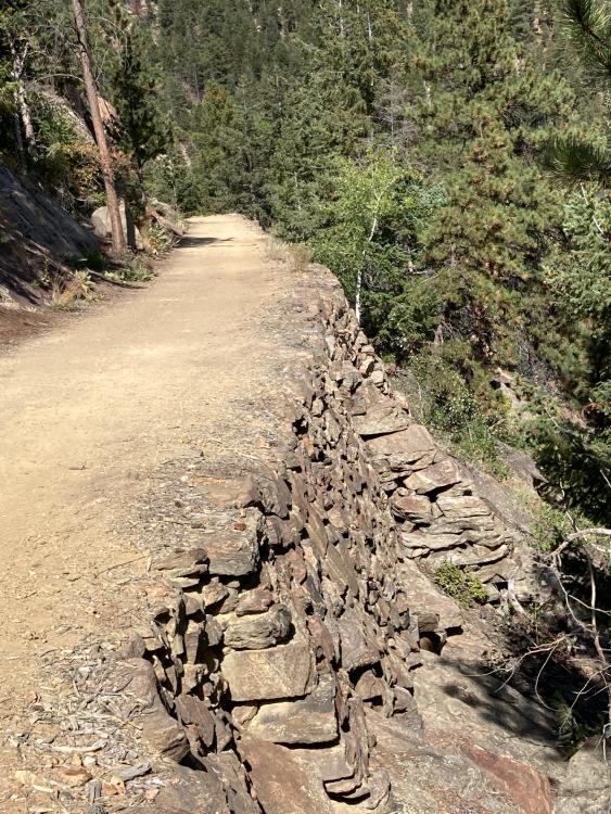
Other parts of the grade required stone retaining walls. These walls were dry laid (no mortar) of stone, and are generally in as good condition as when they were laid 136 years ago. This view is of a typical wall on the east slope of Maryland Mountain.
Keith Pashina
Narrow-minded in Arizona |
Loading... |
Reply to author |
Edit post |
Move post |
Delete this post |
Delete this post and replies |
Change post date |
Print post |
Permalink |
Raw mail |
![]() This view is from the Denver Public Library, Western History Collection, showing Black Hawk. This photo could have been taken from the Chase Gulch Grade. Compare this view to the next photo – much has changed in the past 120 years. ![]() A view from the grade shows Black Hawk below. The Polar Star Mill can be seen just above the green roofed building in the foreground. The 50 Gold Mines/Bobtail mill was about where the red-roofed building located. Very little of Black Hawk milling and railroad construction can be seen today. This photo was taken in 2021. ![]() This photo, from the Denver Public Library, Western History Collection, shows a loaded ore train headed downgrade and approaching Smith Road Crossing. ![]() This is the Smith Road crossing site today. The road is in the foreground, and the grade snakes is way on top of a dry laid stone wall. ![]() Looking back east towards Smith Road, on top of a long stone retaining wall. The building at the upper right is a modern hotel in Black Hawk. ![]() This sketch illustrates how the grade was constructed with dry laid stone retaining walls. (1) dry laid stone is trimmed to shape, and laid up by masons, (2) the space between the laid-up stone and hillside is filled with a combination of rock, gravel and dirt, (3) The hillside was minimally excavated - - it was easier with the hand labor of the day to build walls upward and outward than to excavate and blast into the hillside, (4) Sometimes, the rock wall was laid on top of a rock outcropping. To prevent the wall from sliding outward, sometimes the wall builders drilled holes and inserted metal rods, rail, or whatever was handy to keep the toe of the wall in place. This is shown in the photo at above right. ![]() This photo illustrates the size and how the dry laid stone walls were constructed. Here, I am measuring one the walls back in 1993. Stones ranged size from quite large to small filler pieces. ![]() Where the stone wall was laid on bare rock, and there was a risk of the wall slipping downhill, holes were bored into the rock and old mine rail or drill steel used to pin the rock wall into place. ![]() Some locations required culverts for drainage. Here, Dan Abbott is examining a wooden box culvert laid into the stone wall in 2001. ![]() Some sections of the grade have wooden retaining walls, laid in crib fashion (think of stacking of Lincoln Log toys, such as in a log cabin). The wood segments are usually short, and perhaps represent a repair made to the grade after construction, such as small washout.
Keith Pashina
Narrow-minded in Arizona |
Loading... |
Reply to author |
Edit post |
Move post |
Delete this post |
Delete this post and replies |
Change post date |
Print post |
Permalink |
Raw mail |
![]() At about 750’ further west of the Smith Road Crossing, a spur was laid to serve one of the stamp mills located down in the bottom of the gulch. There was at least a 75’ drop down to the mill, so perhaps the ore was slide down a wooden chute – I have found no record of how the ore was moved. The mill spur was used by the Colorado-Tellurium Gold Mining Company for processing gold ore taken from the Freedom Mine (located on Winnebago Hill, about 2/3 mile further southwest of the mill). The company purchased the former Oliver Mill, renaming it the Freedom Mill. The Mining News reported on November 17, 1904: “This company has purchased the Olive (usually referred to as the Oliver Mill, so, a typo in the account) stamp mill near Chage gulch….For delivering ore to the mill, a switch has been built from the tracks of the Gilpin Tramway Company…From the 500-foot west level daily shipments amounting to three cars are made to the company’s Freedom mill in Chase gulch.” Interesting – for a while, the tramway had short daily haul of three ore cars between the mine and mill. ![]() This is the Oliver, later Freedom Mill in Chase Gulch. The main line ran high above the mill and can be seen just below the top of the smoke stack. The tram built a short spur here in 1904, for unloading ore from the Freedom Mine. The mill in the left background is the Bonanza Mine and Mill – I have seen no record that this was a customer of the Gilpin Tram. This image is from the Denver Public Library, Western History collection, image X-61769. ![]() A contemporary view, looking north. The Gilpin Tram grade can be seen along the south slope of Maryland Mountain. The waste dump from the Oliver/Freedom, and Bonanza Mills can be seen at center. ![]() Now we’re looking west, towards the head of Chase Gulch. The arrows point out the grade. The waste rock dumps at center are the Queen of the West and Virginia Mines, which are actually on the east slope of Winnebago Hill. ![]() Here’s a similar historic view (the photographer can be seen in the foreground). The blue arrows point out the Gilpin Tram grade, the red arrow the Robbert Emmet Mine, and the yellow arrow the Queen of the West Mine. ![]() Here is a sizeable dry laid stone retaining wall with Joe Crea and Dan Abbott standing on top, for scale. ![]() A view of the grade looking east, as we near Castle Rock. The combination of the rock outcropping, trees, and dirt grade could make an appealing model scene. ![]() Here, the Gilpin Tram main line squeezes past a rock outcropping, building up the grade on yet another stone retaining wall. ![]() The Gilpin Tram grade is easily seen here. The waste rock dump in the foreground is from the Queen of the West Mine, and the mine dump on the far hillside at center is the Robert Emmet Mine. We’re looking east in this photo. Nothing remains of either mine today, except for the waste dump.
Keith Pashina
Narrow-minded in Arizona |
Loading... |
Reply to author |
Edit post |
Move post |
Delete this post |
Delete this post and replies |
Change post date |
Print post |
Permalink |
Raw mail |
![]() Climbing further along the grade, we pass by the Robert Emmet Mine. This is another Denver Public Library, Western History Collection photo This apparently was a good producer at one time, and was set along the hillside above the tramway grade. This mine was not a shipper on the Gilpin Tram - perhaps they teamed their ore down to the nearby Bonanza or Oliver Mills, or one of the other mills down in Black Hawk. The Gilpin Tram grade can be seen at the bottom right edge of the photo. ![]() We’re now nearing the head of Chase Gulch. The rock formation is Castle Rock. The Gilpin Tram grade can be seen directly below it. ![]() A closer view of the Robert Emmet Mine, courtesy of the Denver Public Library, Western History Collection. ![]() And now we arrive at the head of Chase Gulch. Castle Rock is at the center, with the Gilpin Tram main line directly below. The Castle Rock Mine is at upper right – I don’t think it was a Gilpin Tram shipper. At left, the main line curves off to the south, crossing over Chase Gulch, which has a high water flow at this time. The track veering towards upper left is the start of the Tucker Mine and Mill branch. ![]() Here is a closer view of the Castle Rock mine, courtesy of the Denver Public Library, Western History Collection. I like the lines of this structure – it would make a great model. ![]() A Gilpin Tram train headed upgrade with two locomotives is nearing Castle Rock. Photo courtesy of the Denver Public Library, Western History Collection. ![]() A closer view of Tucker Mill Junction. The main line crosses over a waterfall made by the stone retaining wall constructed here. A stub switch with harp switch stand controls the start of the Tucker Mill Branch. ![]() This waterfall is Chase Gulch during spring water runoff. The stone retaining wall supported the Gilpin Tram main line as it made a 180 degree curve and started up the north face of Winnebago Hill. What a wonderful model scene this could make! So, this wraps up a short tour of the Gilpin Tram’s Chase Gulch grade. This area has some dramatic scenery, and interesting mining and milling activity. Now that we’re at the Tucker Mill Branch junction, we’ll head up that way next and see what is to be seen there, then continue on up the main line onto Winnebago Hill, and then the mining districts. Until then, Happy New Year. Keith
Keith Pashina
Narrow-minded in Arizona |
Loading... |
Reply to author |
Edit post |
Move post |
Delete this post |
Delete this post and replies |
Change post date |
Print post |
Permalink |
Raw mail |
In reply to this post by Keith Pashina
Keith nice pictures and great modeling ideas thanks. The picture with the photographer showing the arrows shouldn't the
red arrow be up on the mine with the ore bin I think that one is the Robert Emmet Mine. Keith have a great new year thanks again GRUMPY |
Loading... |
Reply to author |
Edit post |
Move post |
Delete this post |
Delete this post and replies |
Change post date |
Print post |
Permalink |
Raw mail |
Grumpy - you are correct. In the photo of the two mines, the Robert Emmet and Queen of the West, the Robert Emmet mine building is above and to the right of the red arrow - the red arrow as I drew it points to a lesser mine structure, not the main facility with its ore bin.
Keith
Keith Pashina
Narrow-minded in Arizona |
Loading... |
Reply to author |
Edit post |
Move post |
Delete this post |
Delete this post and replies |
Change post date |
Print post |
Permalink |
Raw mail |
This post was updated on Jan 11, 2025; 3:24am.
Keith, and "Grumpy",
![]() The small (exploratory) Shafthouse is most likely the John Morris. Note there is an Adit as well, which was the initial start here by him. ![]() USGS ![]() EDIT: added. ![]() ![]() ![]() EDIT: added. ![]() Harry Lake, himself ![]()
UpSideDownC
in New Zealand |
Loading... |
Reply to author |
Edit post |
Move post |
Delete this post |
Delete this post and replies |
Change post date |
Print post |
Permalink |
Raw mail |
Thank you for posting the information on the Robert Emmet Mine, Chris. Also, thank you for identifying the photographer as Mr. H.H. Lake. He took several very useful photos of the area mines and railroads.
Here is another one he took - this apparently is his wife and daughter, and I think this was taken on the top of Winnebago Hill, looking generally westward - note the cemetery in the background. ![]() The above image is from the Denver Public Library, Western History Collection, image L-182.
Keith Pashina
Narrow-minded in Arizona |
Loading... |
Reply to author |
Edit post |
Move post |
Delete this post |
Delete this post and replies |
Change post date |
Print post |
Permalink |
Raw mail |
Administrator
|
So easy I even beat Chris to it. But I'll cut you some slack with your move and all
![]() ![]() |
Loading... |
Reply to author |
Edit post |
Move post |
Delete this post |
Delete this post and replies |
Change post date |
Print post |
Permalink |
Raw mail |
Darel - a good find, thank you. Darel was alluding to my recent move from Minneapolis to Tucson. I can definitely say that I am finding the winter weather here quite enjoyable. I'm still a 12-hour drive away from the Gilpin Tram, though.
That's the Boodle Mine and Mill seen in the background. It's located quite some distance from any Gilpin Tram tracks, and at a much higher elevation, too. Yet, there are records that this mine shipped some ore on the Gilpin Tram. They would have had to move it by horse-drawn ore wagon to one of the Gilpin Tracks. I wonder how and where? ![]() Here's a photo taken of the Boodle in 2005. Since then, the owner(s) have rehabbed the exterior siding, and repainted it. I've been re-reading the Gilpin Railroad Historical Society newsletter, all 50 issues. This group was founded, and the majority of the information written by, Dan Abbott (chief author of THE essential book on the Gilpin Tram, Sundance Publication's "The Gilpin Railroad Era"). There is an impressive amount of information there, and it will be re-visited in future posts. I will be gradually posting more information about the Gilpin Tram, based on Dan's published research, my own research, and help from others.
Keith Pashina
Narrow-minded in Arizona |
Free forum by Nabble | Edit this page |