The Gilpin Tram in Black Hawk

12

12

|
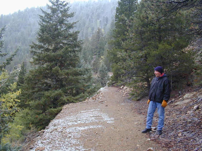
 The Gilpin Tram in Black Hawk I think the Gilpin Tram (for simplicity, I will refer to both the Gilpin Tramway Company and successor Gilpin Railroad by this term) trackage, facilities, industries and operations in Black Hawk are fascinating subjects that deserve a closer look. In some ways, this area is so much unlike other narrow gauge locations, because of the concentration of industries, homes and retail buildings all crowded together, in a bit over a mile in Clear Creek canon. The feel here is more like a big city industrial area. For the modeler, there is a lot here to like. Mill structures vary from narrow to wide, walls of stone, metal and wood, mill buildings with sloping roofs, flat roofs and combinations thereof. Trackage in town includes two foot and three foot gauge, and extensive dual gauge and the trackwork bridges crosses Clear Creek and its tributaries numerous times. The Colorado Central was built to serve the rich mining towns of Black Hawk, Central City, and satellite towns, following rich gold strikes beginning in the 1850s. However, by the 1880s, the mining district was hurting. Operations had evolved from capturing the easy-to-reach gold in placers and shallow shafts and tunnels, to having to mine more complex ores at greater and greater depths. The mining districts began reconstructing shaft houses with more technically advanced and larger hoists and equipment. But, even though there was plenty of ore to claim, their gold, silver, and other metals content tended to be lower. The plentiful, but lower-value ore meant more ore shipped to the mills, but their lowered value increased costs, and strained the capabilities of the local teamsters to haul it. Even worse, the ores at greater depths became more complex in their mineralization, meaning the formerly productive milling techniques no longer were capturing much of the gold and silver in the ores – more and more was going out the launders into the tailings dumps. The district was declining, and things would get worse, unless these issues could be overcome. Fortunately, advances in milling and smelting methods found ways to get most of the values from the ores, and mining was rejuvenated and expanded rapidly. As luck would have it, another technical marvel was available to help develop the Gilpin County mines – a very narrow gauge tramway. The 2’ gauge Gilpin Tramway was constructed to serve the local mines and mills in Gilpin County. The mines needed coal and assorted supplies hauled in, and the mills received the ores for further processing. The tramway was able to very economically haul the lower-valued ores to the mills. Almost all of this traffic either originated or terminated in Black Hawk. 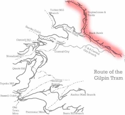 The red-shaded area shows the Black Hawk area The Gilpin Tramway (and beginning in 1906, the Gilpin Railroad after the C&S purchase) based its operations in Black Hawk, and served the many mills through a network of spurs and dual-gauge trackage. There was a freight transfer, too, where coal and other supplies were received from the Colorado Central/C&S, and ore shipped out to mills and smelters not located in Black Hawk. 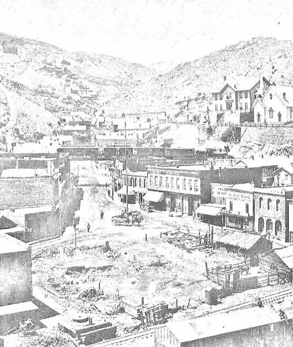 Black Hawk has a lot of interesting features that make for great modeling subjects: 2 narrow gauges, interesting structures, all crowded into narrow mountain valleys 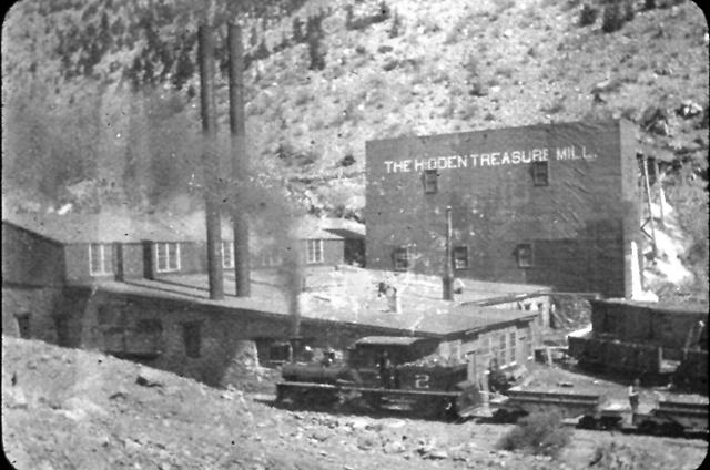 Shay #2 is pulling empty ore cars back to the Black Hawk yards, chuffing past the Hidden Treasure Mill. This mill was also directly served by the tram 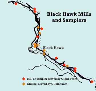 A map showing the locations of the mills, sampling works, and concentrators in Black Hawk The Gilpin Tram Warming House 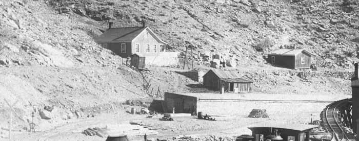 The Gilpin Tram’s warming house only appears in a few photos. This enlargement of a photo in the Denver Public Library, Western History Collection (image Z-187) shows the warming house This is an enlargement from a photo in the Denver Public Library collection, and shows the north end of the warming house. A harp switch stand for the lead track to the warming house can be seen by the left margin (next to the railroad crossing sign for the wagon road). There are ties and barrels stored by the warming house. The track enters what appears to be a wooden sliding door, where inside, the track branched out into three parallel sidings Across Clear Creek from the engine house, the Gilpin Tram built a stone warming house. This structure was need to provide a place for loaded ore cars to be parked and warmed until the ore loads thawed. The gold-bearing ores tended to be mined in wet conditions, so during winter months, the ore often froze up. By parking the loaded ore cars overnight, or for several hours in a heated structure, the loads would thaw, and then be taken to the various mills to be dumped into the ore bins. 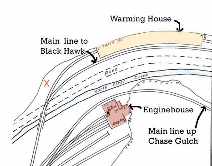 The Gilpin Tram’s enginehouse area. The warming house was on the east side of Clear Creek. The red “X” shows the location of the possible water tank discussed in the thread, “Speculation on the Gilpin Tramway at the Black Hawk Roundhouse” begun by Chris Walker on February 2, 2023. 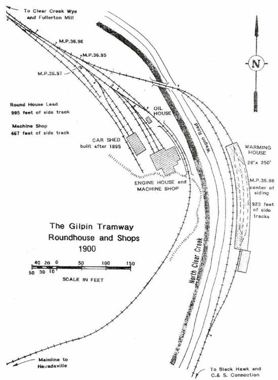 This map was drawn by Dan Abbott, and originally published in Issue 4 of the Gilpin Railroad Historical Society Newsletter. A similar map of Dan's was also published on page 33 of the book, The Gilpin Railroad Era. Dan's research shows the mainline down into Black Hawk passing by the stone structure, next to the creek. Dan's research showed the building eventually measured 28' wide by 250' long, and had three tracks inside. I think this structure was modified quite a bit over the years. Originally, the building was heated by a series of stoves, but later, a large boiler was set up, and fed steam pipes throughout the building. The small structure addition on the south end may be a boiler house. This structure was located on a sloping grade, so the loaded ore cars would be dropped by gravity into the north end of the building, and on to one of the three interior tracks. In the morning, the now-thawed cars would be carefully dropped down onto the main spur on the south side of the warming house, to be picked up and switched by one of the shays. The building was too low for locomotives to go inside. 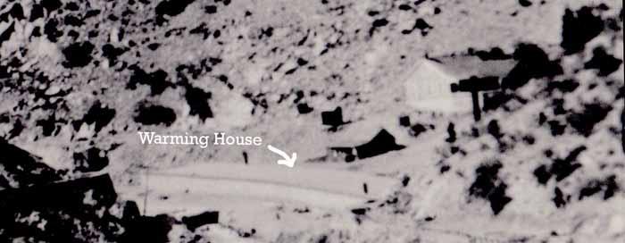 Photos of the warming house are rare, and it appears in the background in only a few older photos. This is another enlargement of a Denver Public Library, Western History Collection photo, and shows a (distant) overall view of the warming house. There are two houses next to the engine house. On the far right (north side), there is a large structure of some size. I thought this was an ore bin for a nearby mine, but Chris Walker’s recent thread here indicated this could possibly be a squarish water tank.  By the 1980s, not much remained of the warming house, except for a few stone walls on the north end of the structure. These were later buried under dirt fill for construction of a parking lot.  The former Gilpin Tram mainline up Chase Gulch has been turned into a regional trail for hikers and mountain bikers. The trailhead, next to Highway 119, is on the former site of the warming house
Keith Pashina
Narrow-minded in Arizona |
|
|
It is a very fascinating prototype. I miss your posts over on the Freerails forum on the modeling the Gilpin tram threads. Any idea what happened there when the forum went down? I thought I would share that some is preserved on the wayback machine on archive.org. However any pics hosted on their server do not seem to show (or at least quite a few are missing) and several pages are gone. Here is what is left. If a page does not appear you can select a different date on the top.
Part one https://web.archive.org/web/20220928194607/https://www.freerails.com/view_topic.php?id=4599&forum_id=17 Part two https://web.archive.org/web/20221003040746/https://www.freerails.com/view_topic.php?id=7338&forum_id=17
Jim Curran
|
Re: The Gilpin Tram in Black Hawk
|
|
Yes, I had been posting on the FreeRails forum for about 10 years.
 FreeRails was an interesting site - it had lots of very creative modelers on it, and a lot of the material was stuff you saw no where else. I knew a couple of the moderators, and they gradually dropped out. In the end, all I know is that of January 1 of this year, I could no longer access the site. Since it has been over 7 weeks now, I assume the site is not coming back. Jim, thanks for post the wayback links to the site. These may be useful to others. Fortunately, I have my own backups, so all of the original photos and the text have survived. If there is interest in this group, I will continue to post Gilpin Tram stuff, and eventually recreate what was on FreeRails, with the benefit of adding new information I've come across in the past few years.
Keith Pashina
Narrow-minded in Arizona |
Re: The Gilpin Tram in Black Hawk
|
|
Good to see you here, Keith! I've always considered the Gilpin Tram to be a part of the C&S family!
I have my own backups, so all of the original photos and the text have survived. If there is interest in this group, I will continue to post Gilpin Tram stuff, and eventually recreate what was on FreeRails, with the benefit of adding new information I've come across in the past few years. By all means, pleas do! If you have any Gilpin drawings, Darel or Mike can add them to the files section as pdf's. A quick question, we recently discussed this photo that showed up on eBay:  Doug Heitkamp identified the location as the train is moving down grade along Eureka Gulch in Central City (see: http://c-sng-discussion-forum.254.s1.nabble.com/C-amp-S-Photos-on-eBay-td8859i240.html#a18396). What the heck are the two steel towers on either side of the Gilpin train??
Jim Courtney
Poulsbo, WA |
|
|
In reply to this post by Keith Pashina
Glad to hear that part has survived. I had seen while trolling through archive that many photos were missing especially with a couple of posters (but can not remember who) I know anything I had put in their picture archive of Nevadaville was not showing. Someone on another forum had noted that it was past time for their renewal so I would guess that it is gone permanently. I would like to encourage you to share these posts also in the C&S group on Facebook (Pretty please  ) We do include the Gilpin there. https://www.facebook.com/groups/ColoradoandSouthernNarrowGauge ) We do include the Gilpin there. https://www.facebook.com/groups/ColoradoandSouthernNarrowGaugeThanks Jim Curran
Jim Curran
|
Re: The Gilpin Tram in Black Hawk
|
|
In reply to this post by Jim Courtney
Jim,
As you noted, there two towers in this photo: 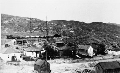 The two towers are identified as "wireless towers" on page 33 in Frank Hollenback's "The Gilpin Tram", published in 1958. This seems plausible - if the photo were taken in 1900-1917, radio had been invented by then, so someone must have been experimenting... I think in this photo, the train has just passed by the Eureka Street Water Tank and headed down to Black Hawk.
Keith Pashina
Narrow-minded in Arizona |
Re: The Gilpin Tram in Black Hawk
|
|
Keith,
Great to see you posting the Gilpin info. There was a lot on that Free Rails site and it would be very sad if it disappeared. I say post away! Also, thanks for the reference to the "wireless towers" in the photo above. Jim Courtney was asking about those a short while ago. Regards,
Doug Heitkamp
Centennial, CO |
|
|
Great news on Freerails
This appeared this morning when I just out of curiosity checked the site "Freerails has returned with a new host. Please be patient as we test the new system. The forum will open as soon as data integrity reaches 1" Great to hear! Jim Curran
Jim Curran
|
|
|
I am afraid that you are wrong. Everybody knows there is nothing
interesting about Colorado narrow guage railroading, especially in the Clear Creak area.
"Duty above all else except Honor"
|
Re: The Gilpin Tram in Black Hawk
|
|
GILPIN TRAM ENGINEHOUSE AREA
Across Clear Creek from the Gilpin Tram’s warming house was the engine house, a small yard, wye, and shops. The Gilpin Tram referred to their engine house as the “roundhouse,” but there was nothing round about it. The Gilpin Tramway purchased and modified a former horse barn on the north side of Black Hawk, about 1/4 mile north of town. In the narrow Clear Creek Canyon, there wasn’t much real estate available for railroad tracks and buildings, so reusing a conveniently located barn fit in well with the Gilpin Tramway’s inexpensive construction philosophy. An early photograph shows that the barn was modified by cutting in a door for one locomotive stall at the west end, for the Gilpin Tramway’s first locomotive. The barn also may have been sheathed in metal siding around this time. 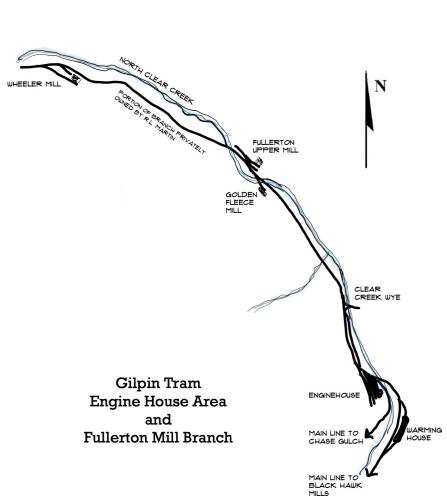 A map showing the enginehouse and yards area, and Fullerton Mill branch north of there. This and the next few posts will cover this area. Later on, as the roster grew, an extension was added to the west side, and the barn, now called a roundhouse by the Gilpin Tramway, was modified for 3 locomotive stalls. These stalls were very small, built just wide enough and tall enough for the railroad’s diminutive shays to fit inside. The end stall was built slightly wider and taller than the other two stalls, probably when the larger Shay #5 was purchased. 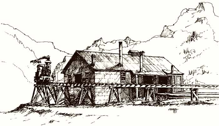 A wonderful sketch by Joe Crea, showing the enginehouse with themain line trestle passing by. This depicts the “final” version of the engine house, when it had been enlarged to three stalls. The engine house was set right next to the main line that headed up Chase Gulch, and eventually, to the mines. The main was on a wooden trestle, needed to gain elevation around a rock outcrop and pass over part of Clear Creek. The trestle was so close, that a corner of the roof was notched to allow clearance! Later on, the trestle was at least partially filled in with soil. The Gilpin Tramway also built a few other buildings on this site. A small shed, possibly to house flammable paint or oils, sat in front of the engine house. And of course, directly across the river was a warming house, where loaded ore cars were parked overnight and thawed out during cold winter months. Sanborn maps also show a two-stall car shed built at the ends of the two spurs that ran next to the engine house. I have never seen a clear photograph of this building, but it first shows up on the 1895 insurance company map. 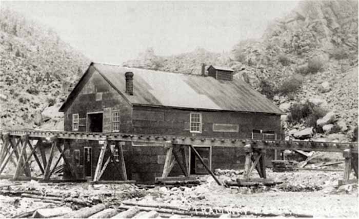 At first, the engine house was a single stall, as the tram only had the one locomotive. This would be later expanded to two, and finally three stalls. The origins as a horse barn are evident here, even though contemporary news sources refer to this as the “roundhouse”(from Denver Public Library, Western History Collection, image Z-3481). 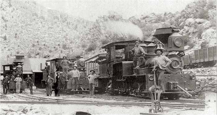 By now, Shays 1, 2, and 3 were on the property, and proudly lined up for this photo by the engine house. This image is from Denver Public Library, Western History Collection, image Z-3476). 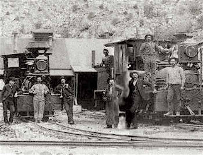 A closeup of the same image as above shows some more details of the doors to the engine house stalls. 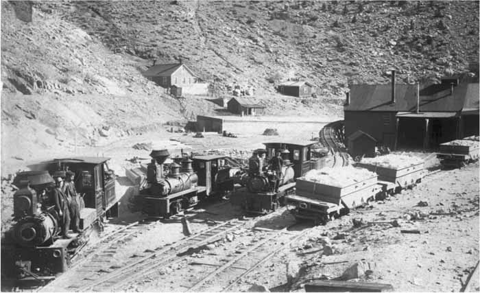 This photo shows Shays 1, 2 and 3 again at the engine house. The warming house can be seen across the creek. There are two tracks next to and up the slope from the engine house, apparently used for classifying cars to be switched to the mills, and for excess car storage. This image is from Denver Public Library, Western History Collection, image Z-187). 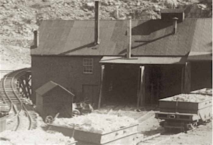 A closeup from the same image as above, shows a small shed in front of the engine house. This shed may have been used to store flammable materials, such as oil, grease, and paint. 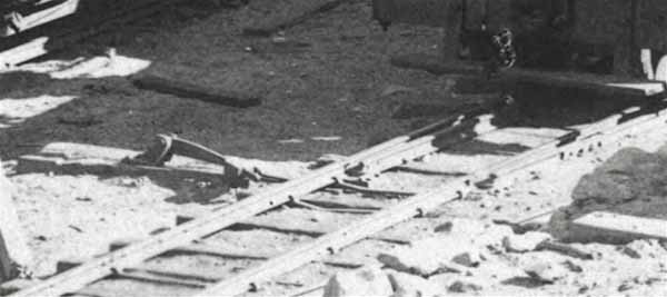 Another close-up of the same image – showing a ground throw for one of the turnouts in front of the enginehouse. Chris Walker originally discovered this while scrutinizing images of the area. 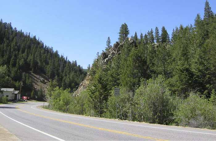 If you visit the engine house today – you will likely get your feet wet, and find – nothing. During a low-water month, I walked across the creek, and could not find much, Some small pieces of wood, sheet metal, and brick, but no foundations or any indication a railroad had ever been here. Highway 119 construction appears to have altered the creek bed location, from Gilpin Tram days,too. 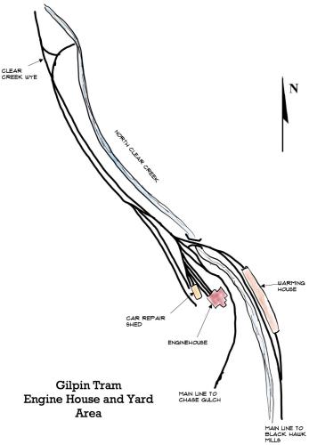 This map shows an overall view of the enginehouse and yard area 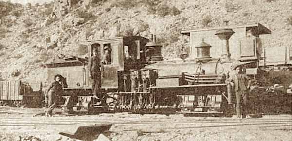 Shay #3 is posed in the tracks immediately in front of the engine house. Behind it, one of the caboises and one of the coal cars can be seen on the storage tracks. This image came from a Brotherhood of Locomotive Engineers 1903 magazine article. 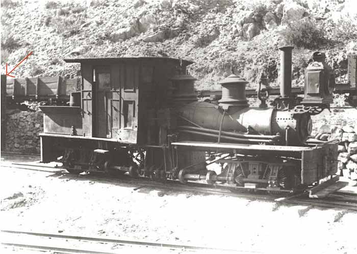 Shay #1 was the first locomotive, and was sold off in 1905 to the Silver City, Pinos Altos and Mogollon Railway in New Mexico. Here appears to be stored, possibly prior to its sale. Note the red arrow at left margin – it points to what appears to be one of the doors to the car shop. No other image of the car shop appears to be available. Image from the Colorado Historical Society, image CHS.X9533. 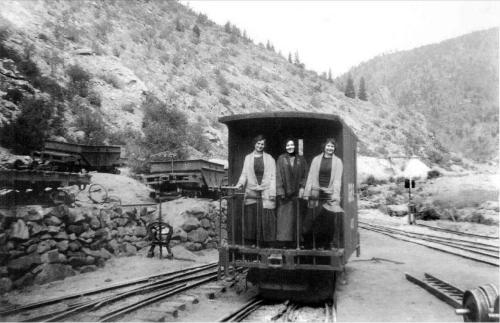 This image shows three young ladies on the end platform of Caboose 400, constructed after the C&S purchase. Note there are three types of switchstands in use in the yard area – the much-abused harp switchstand that no longer has its target, a rotary stand (to the right of the caboose), and the ground throw previously show in this post. Photo courtesy Mark Baldwin collection. 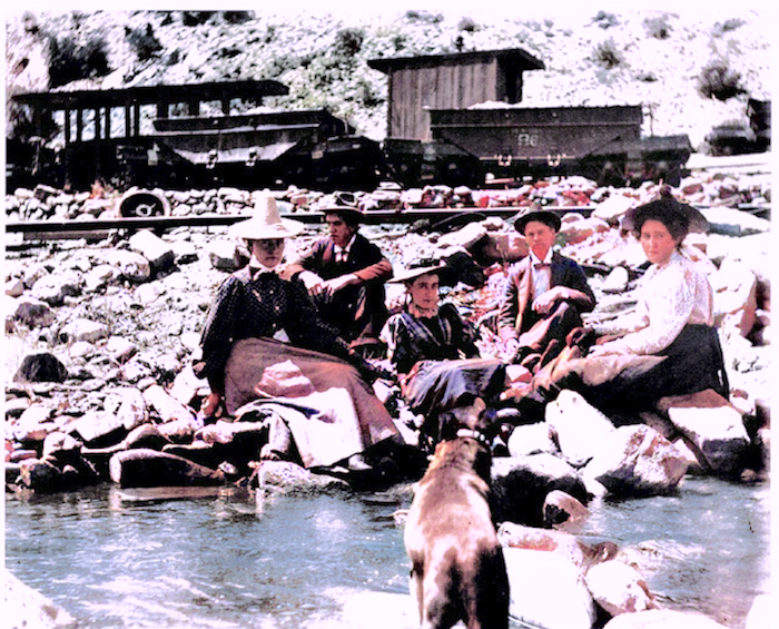 I couldn’t resist trying out a photo app to colorize this photo. I don’t know if the colors are correct or not, but it does bring the little group touring the area to loife. Note an excursion car, caboose, and three ore cars in the background. Photo courtesy Mark Baldwin collection.
Keith Pashina
Narrow-minded in Arizona |
Re: The Gilpin Tram in Black Hawk
|
|
The Fullerton Mill Branch
At the Gilpin Tram’s engine house, if we looked north, we would have been peering over the runaround track and wye, and looking up Clear Creek at what was known as the Fullerton Mill Branch. 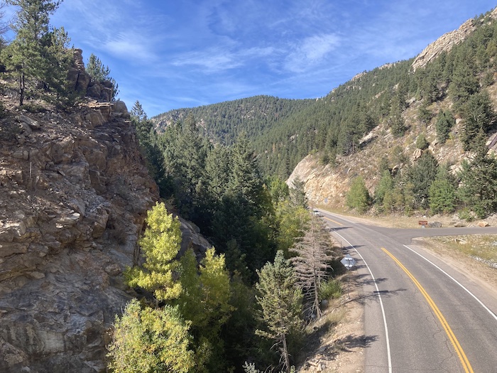 Looking north from the enginehouse site. The mainline up Chase Gulch and to the mines curved around the rock outcopping on the left side of the photo. Looking straight ahead, we are looking up Clear Creek Canyon, and the general route of the Gilpin Tram’s Fullerton Mill Branch. M.P. 36.95 SWITCHBACK No. 1 (Engine House) The Fullerton Mill branch officially began at the engine house, at milepost 36.95. This is where the mainline began its climb up Chase Gulch, the main headed downgrade to Black Hawk and several mills, and the trackage north went to more mills. The Fullerton Mill Branch extended for about a mile to the northwest. The branch started out on the west side of Clear Creek, crossed over to the other side to reach two mills, then crossed back to the west side to reach the Martin/Wheeler Mill. This branch was built to serve three ore-processing mills: the Golden Fleece/Brooklyn/Gunnell Gold M & M Company, the Fullerton Upper Mill, and the Martin/Wheeler Mill. The owners of the Martin/Wheeler Mill owned the trackage from “Martin Junction” at milepost 37.32, the to their mill, which was 2,693 feet of trackage, or about 0.51 miles. The branch was built early in the life of the tram – newspaper records show the branch was in place to the Upper Fullerton Mill in 1887. 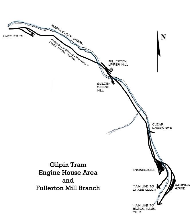 Map of the Gilpin Tram’s Fullerton Mill Branch GOLDEN FLEECE/BROOKLYN/GUNNELL GOLD M & M COMPANY This small mill was about 0.3 miles north of the engine house, although official records don’t document its location. I have never seen a photo of this mill, nor are there many records describing it. What we do know is that it started out known as the Golden Fleece Mill, maybe, although I don’t know this for sure, before the tram. Newspaper reports mention in processing ore from the Rialto Mine, in 1893 and 1894. Later on, the mill was described as the Brooklyn Mill, then finally as the Gunnell Gold M & M Company. This latter name implies it was part of a larger conglomerate of the mines consolidated on Gunnell Hill. The 1917 USGS Economic Geology of Gilpin County report stated this mill had 1 jaw crusher, 10 stamps, amalgamating tables, jigs, and Gilpin bumping tables. The report describes this mill as still extant in 1917, but I don’t know when it quit operating. 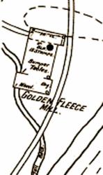 The 1895 Sanborn Fire Insurance Company map shows the Golden Fleece Mill, which was served by the Gilpin Tram. The landscape in this area has been greatly changed since Gilpin Tram days. The highway construction has moved the creek to the west side of the canyon, and has been partially built over the old grade. However, the concrete foundations for the Golden Fleece/Brooklyn/Gunnell Gold M & M Company mill can still be found, now down in the creek bed. This area is heavily overgrown with underbrush, and in the summer, when the bushes are leafed out, almost impossible to find. My impression of the ruins was that the shape of the foundation was similar to what was depicted in the Sanborn Insurance Company map. 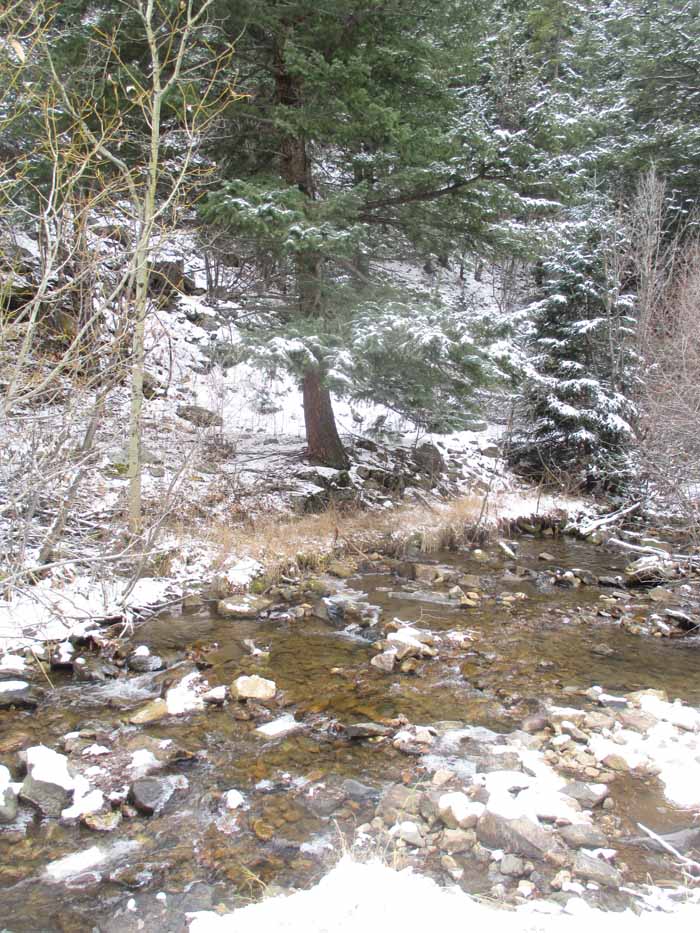 The general site of the Golden Fleece Mill is overgrown today. Road construction seems to have shifted Clear Creek further to the west side of the canyon, so that the foundations are very close to the creek and the soil eroded. Some of the concrete foundations of the mill can be found in the underbrush. M.P. 37.31 UPPER FULLERTON MILL SPUR This mill apparently had two spurs to it. The upper track was 728 feet long, according to Dan Abbott. Dan also reported that some maps described this spur as having one switchback before it reached the mill building. Over the years, this mill was variously known as the Gunnell Mill, St. Louis-Gunnell Mining and Milling Company, and the Kimball & Fullerton Upper Mill. Mine production records said the mill had a 30-ton ore capacity each 24 hours, and used 20 stamps. William Fullerton was a prominent mining man in the area, and built his first mill in 1867. He also owned the Gunnell Mine for a while, one of the largest producers in the area. 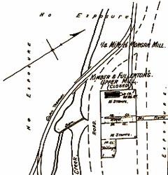 The 1895 Sanborn Fire Insurance Company map shows the Upper Fullerton Mill, which was served by the Gilpin Tram. Some maps show two spurs to the mill – one at the upper (right side), presumably to dump ore, and one near the base of the mill (left side). Highway construction has obliterated the site, and there are no remains of it today. Also, I have never seen a photo of this mill. There are very few records of this mill’s use, but it was used by the Tramway soon after railroad construction. The Weekly Register-Call, a Central City newspaper, reported some details on July 15, 1892: The St. Louis-Gunnell Mining and Milling Company have placed sheet iron on their mill building, on North Clear Creek above Black Hawk, which has received a new coat of mineral paint. Before the water season is over and cold weather sets in, the company will secure a new steam boiler to supplant the upright boiler formerly in use. They will also widen the building on the east side, and add such other improvements to the premises as will better facilitate the milling of ore taken out by them from their group of mines on Gunnell hill this city. This will give them more room in which to store concentrates, and better facilitate the loading of the same into the Tramway company’s cars. Since I built a model of this mill, I was interested in learning the mill was clad with sheet metal siding, painted mineral, which I would interpret to be a mineral red. Also, note the reference to Gilpin Tram cars being loaded. The article is also noting the upgraded boiler is needed to power the mill, which presumably used a water wheel to power the mill when Clear Creek had good water flow. The same newspaper reported on August 25, 1893: The main line of the Gilpin County tramway company is now extended to the Fullerton upper stamp mill, which is located only a short distance below. (note – the remainder of the news story is referring to the Wheeler Mill) Note that within a year, the name reference changes from the Gunnell to the Fullerton mill. The news editor is loose on the name of the Gilpin Tram, too. Things were busy here 8 years later, when the Gilpin County Observer reported on May 23, 1901: Last week the Gunnell Gold Mining and Milling Company kept 80 stamps dripping on ore from the Gunnell and Grand Army shafts on Gunnell hill. This week they have kept 53 stamps dropping. The upper mill on North Clear creek, 33 stamps, is kept employed on ore from the workings of the Grand Army shaft. I always thought stamps were used in group of 5 stamps per battery, but obviously not. 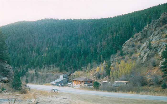 This is looking southeast in Clear Creek Canyon, and at the approximate location of the Martin/Wheeler Mill. The buildings here are not original to the Gilpin Tram. That is Highway 119 in the foreground. M.P. 37.32 MARTIN JUNCTION This junction was on what would probably be a switchback to the Upper Fullerton Mill spur, and was very close to this mill. A Mr. R.L. Martin owned this trackage, and it was used to reach his Martin/Wheeler Mill. R.L. Martin was a prominent mine and mill operator in the area, and he also owned the Gettysburg Mine, and I have seen his name mentioned with several other mining ventures. 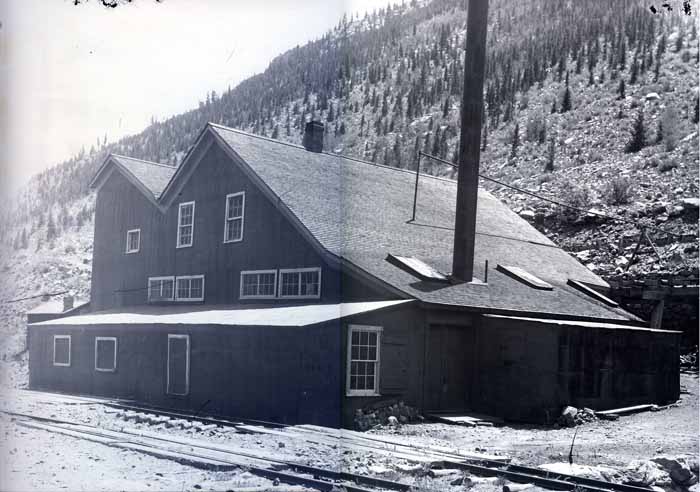 The Martin Mill, or better known as the Wheeler Mill. This photo courtesy of the Mark Baldwin collection. The branch grade is closest to the photographer, and there is a spur, perhaps to unload coal, next to the mill. I think there was an ore unloading spur on the opposite side of the mill, not shown in this photo. This is a very unusual building configuration for a mill, not typical of others in the area. M.P. 37.77 WHEELER MILL (ON MARTIN’S EXTENSION) The Martin/Wheeler Mill was also known as the Climax Mill at various times, according to Dan Abbott’s research and local newspaper accounts. An 1879 Mines Directory also lists this as the “Bostwick and Wheeler Mill.” But, the same report describes this as the “Wheeler Mill, owned by W. Wheeler and D. Sullivan” – I mention this to demonstrate how challenging it can be to track information on these operations – there were frequent changes. This mill had 25 stamps and outside amalgamating tables, 5 Gilpin County bumping tables, and could handle 37 tons of ore each 24-hours. 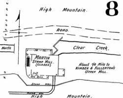 The 1895 Sanborn Fire Insurance Company map shows the Wheeler Mill. The Gilpin Tram trackage is not shown The Weekly Register-Call reported on the mill on August 25, 1893, and noted the mill was operated with a 28-foot diameter water wheel with an 8-foot face, fed with a 2’ x 3’ flume. The flume was being replaced with a new one, and workers were slightly altering the Clear Creek channel to make more room for concentrates storage. The stamps were of the “modern Gilpin County pattern” – more on that later. There was also a boiler and 35-horse power steam engine in use. The mill also had five “Gilt Edge concentrating or bumping tables”, too. And, of greatest interest to us: The main line of the Gilpin County tramway company is now extended to the Fullerton upper stamp mill, which is located only a short distance below. This is a probability that this enterprise will be extended up the creek to the mill, should proper terms be made for the tramway company for transportation of the Climax mine to the mill. Of course, we know track was eventually laid this mil. I think there were 2 spurs to this mill: one for coal unloading and supplies, and an upper track for presumably ore unloading. Both spurs faced south, so train movements would have required the train to pull the train up to the mill, then work the spurs. Since this branch is on a steep upgrade from the engine house, the shays must have put on a good show when switching the mill! 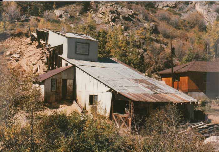 The mill is on or near the former Wheeler Mill site. It was built sometime after the Gilpin Tram ceased operations, and this particular structure was demolished perhaps 15 years ago. The Gilpin Observer reported on August 31, 1899, that the mill was being overhauled, still a 25-stamp mill and the mill still used water power whenever the creek flowed, and mentioned: “…is connected with the main track of the Gilpin County tramway.” I could find no detailed records of shipments or traffic to this mill. By 1917, this mill was reported as being partially dismantled. When the mill quit operating is unknown. We are fortunate to have a photo of this mill. Mark Baldwin, who also hosts the Gilpin Gold Tram website, gave permission to use this photo. This mill is looks very different from the typical mills in the area – it seems to be a wood-framed building with peaked, shingled roofs. 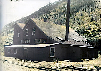 This is the photo from the Mark Baldwin collection, which was colorized by my photo software program. I don’t know if the colors are realistic or not, but to me, this helps hring the structure to life. This would make a unique and very interesting model.
Keith Pashina
Narrow-minded in Arizona |
Re: The Gilpin Tram in Black Hawk
|
|
Keith, this is wonderful information. Please do keep it coming!
Dave Eggleston
Seattle, WA |
Re: The Gilpin Tram in Black Hawk
|
|
Ditto what Dave said!
I cannot wait for the next installment!
Keith Hayes
Leadville in Sn3 |
|
|
Great stuff- Looking forward to more- I am glad to report that the Freerails forum is back up
Gilpin Tram part one https://www.freerails.com/view_topic.php?id=4599&forum_id=17 Part two https://www.freerails.com/view_topic.php?id=7338&forum_id=17
Jim Curran
|
Re: The Gilpin Tram in Black Hawk
|
|
In reply to this post by Keith Pashina
"Please, sir . . . I'd like more"
Feel free to add photos of your HO interpretations of the scenes as well!
Jim Courtney
Poulsbo, WA |
|
|
Caught Keith's excellent presentation on Narrow Gauge off the Beaten Track today- excellent Keith. https://www.youtube.com/watch?v=HnOTpVBrHgk
Jim Curran
|
Re: The Gilpin Tram in Black Hawk
|
|
THE HIDDEN TREASURE MILL AND VICINITY
 A map showing the Hidden Treasure Mill trackage. The Gilpin Tram mainline up Chase Gulch is the left-most track. The line down to Black Hawk and more mills is the line on the right bank of Clear Creek.  Shay #2 passing the Hidden Treasure Mill. Photo courtesy of Mark Baldwin collection. The previous posts began at the Gilpin Tram’s warming house, moved across the creek, examined the “roundhouse” and small yard facilities, and then looked at the three stamp mills along the short Fullerton Mill Branch. Now, we’re going to go back to the starting point, and head south from the Gilpin Tram engine house area. The Hidden Treasure mill was served by both the Gilpin Tram and Colorado Central/C & S, and this area is well worth taking a closer look. 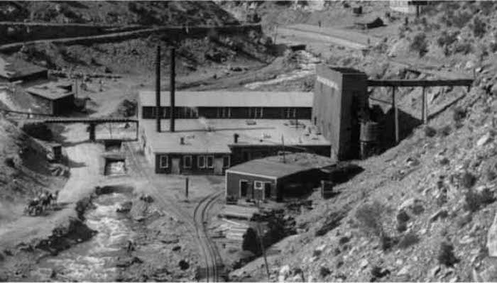 Overall view of the Hidden Treasure mill. Photo from Denver Public Library, image L-50. The main line split into two directions, the line on the east side of the Clear Creek heading south, towards the Hidden Treasure Mill and other mills in Black Hawk. On the opposite side of Clear Creek, the main line headed in the other direction up Chase Gulch, towards the numerous mine branches. The line heading along Clear Creek and to Black Hawk went past the previously mentioned warming house, wound around a bend in the creek and soon reached the Hidden Treasure Mill. The Hidden Treasure Mill marked the end of the 3’ C&S dual gage trackage, and the beginning of the 2’ gauge-only Gilpin Tram. This point was mile marker “36.77 – End of C&S Track,” as designated referring to the C&S Official Mileage Table dated July 1, 1914. 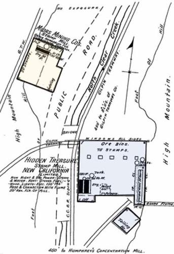 The Hidden Treasure Mill (blue) and Midas Mill (yellow). From Sanborn Fire Insurance map, 1895. This mill was also known as the New California Mill – At various times, this mill had been either owned by or associated with the mining interests that operated the California and Hidden Treasure Mines on Quartz Hill, along with others. This mill was also the furthest upstream that the 3' gauge Colorado Central/Colorado & Southern reached. The C&S actually had two spurs here. One spur branched off to the east (right), and may have been used for loading ore concentrates, supplies, and possibly unloading coal. The wood-framed shed on the east side of this spur is identified as a “Tailings House” on the 1895 Sanborn Fire Insurance Map. The other track was dual gauge, and 2' and 3' gauge and passed by the west (creek) side of the mill. The C&S track ended here. See those big doors in about the middle of the left wall of the Hidden Treasure Mill? Those were used to unload coal from C&S coal cars into the mill. At the mill, the large box-like structure at the upper right houses a water wheel to power the mill. Many mills along Clear Creek used water wheels to power the mills during periods of high water. When water flow was low, they reverted to steam power. This was common to the mills near Black Hawk. The mills along the Fullerton Mill Branch also used this system. 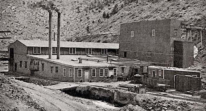 The mill’s west side. From Glimpses of Golden Colorado, 1908 promotional brochure. 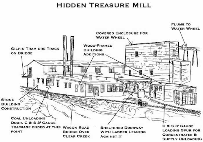 Sketch showing some of the more salient features of the mill. 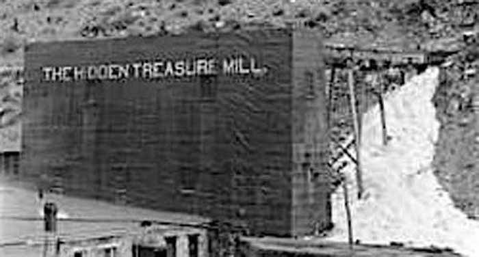 Closer view of the large enclosed water wheel, used to power the mill when the creek was running high. The boilers would be fired up and steam-power used to operate the mill when water levels were low. 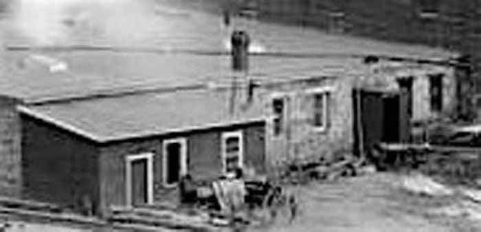 The south wall of the mill has manuy details – stone and tarpaper construction, stored junk, and a parked wagon.  There were two interesting outbuildings by the mill and C&S spur.
Keith Pashina
Narrow-minded in Arizona |
Re: The Gilpin Tram in Black Hawk
|
|
 This is where the switchback spur diverged from the Gilpin Tram mainline. That is our intrepid moderator Darel Leedy standing on the mainline grade. The Hidden Treasure/New California Mill was, at one time, a very important shipper on the Gilpin Tram. This mill at its peak had 75 stamps, amalgamating tables, and Gilpin County Bumping Tables. As years went by, the mill seemed to have been downgraded, and its capacity reduced. The 1917 Economic Geology USGS report noted that the mill had formerly had 40 stamps, and now was reduced to 10 stamps. The other mainline, the one heading up Chase Gulch, had a spur about 150’ from the engine house. This was a switchback spur branching off from the main, and directly served the Hidden Treasure Mill. This location C&S Official Mileage Table dated July 1, 1914, is mile marker “37.05- HIDDEN TREASURE MILL SPUR No. 1”. The same spur passed next to the Midas Mill, but this mill appears to have been closed down before the Gilpin Tram was built. Sanborn Fire maps from 1900 note the structure was closed and dismantled by then. The Midas Mill had 20 stamps at one time. This mill also may been have named the Dallas Mill, based on a Weekly Register Call newspaper report dated March 9, 1894. 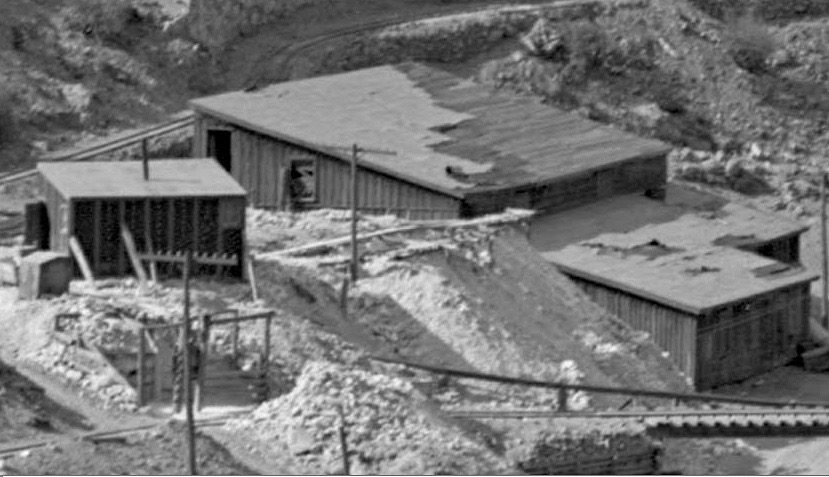 The switchback spur descended down on the west side of the abandoned Midas Mill. It’s an interesting small mill structure. Next, we encounter a short spur and what appears to be an ore bin. What was this for? I think this was for loading ore into cars from the nearby Margaret Glenarm Mine, and then the cars were switched into the Hidden Treasure Mill. There is this report in the Gilpin Observer dated July 19, 1900: “The Central Improvement Company are working the Margaret Glenarm vein on the easterly slope of Maryland Mountain…The ore from the Margaret Glenarm is trammed directly from the mine through the Midas tunnel workings to the Hidden Treasure stamp mill where it is treated.” 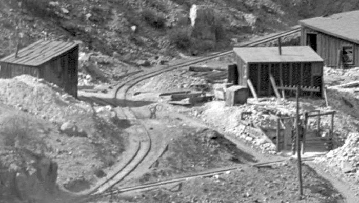 This S curve is winding around to the tail of the switchback, on it’s way to the Hidden Treasure Mill. The short spur and small ore bin at left may be where the Margaret Glenarm Mine ore was loaded into ore cars, then moved the short distance into the mill for dumping. Traffic records for this mill seem to be minimal or non-existent, and I have no good information regarding how traffic ebbed and flowed over the years. A report, “Summary of Mineral Industry Activities in Colorado”, published 1922, notes that no mills were operating in Gilpin County by that time. However, an example of how the unexpected sometimes occurs, there is a report in the Gilpin Observer newspaper on May 9, 1902, reporting, “ There was received last Saturday at the Hidden Treasure mill in Black Hawk three Colorado & Southern railroad cars loaded with stamp mill ore from a gold mine in New Mexico for treatment at that mill. There were six cords of ore, or about 50 tons.” Today, the site is a wooded slope, and heavily altered over the years by Highway 119 construction. I have not found any artifacts indicating a mill had ever been located here! 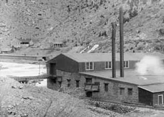 The tram spur entered the mill on a short trestle that extended over Clear Creek and the Gilpin Tram mainline to Black Hawk. This point was also the northernmost extent of the Colorado & Southern trackage. 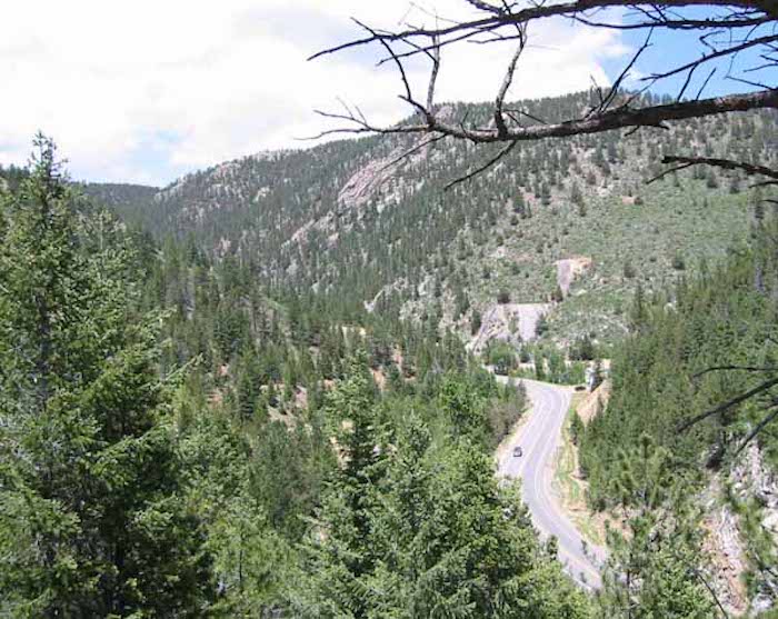 Driving by the mill site today, one would never know that this large mill complext once sat here. The site has been modified since this photo was taken – now there is a visitor parking lot and pedestrian bridge crossing Hwy 119, for the Gilpin Tram hiking and biking trail that heads of Chase Gulch. Lots of modeling inspiration around this area. I have never had the space to really model this mill, but it would make an impressive model, with the switchback, bridges crossing the creek and trackage, dual-gauge track, etc.
Keith Pashina
Narrow-minded in Arizona |
Re: The Gilpin Tram in Black Hawk
|
|
MORE ON THE UPPER BLACK HAWK MILLS
In previous posts, we started at the upper end of Clear Creek, and looked at the Gilpin Tram’s engine house and small yard, the Wheeler, Golden Fleece, and Fullerton mills on the Fullerton Mill Branch, and the Hidden Treasure Mill. In the next few posts, we will look at four more stamp mills, and the Gilpin Tram – C&S freight and ore transfers in upper Black Hawk. 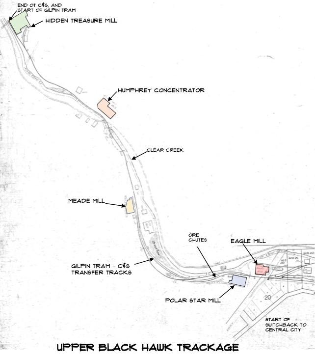 This map shows the locations of the next four stamp mills we will look at, and the Gilpin Tram - C&S ore and freight transfers in Black Hawk Continuing following Clear Creek downstream, we encounter two more mills that were literally “just around the bend”. From the Hidden Treasure Mill, the main trackage was dual gauge 2’ and 3’ all the way to the south end of Black Hawk. Along the route, there were some dual gauge side tracks, as well as individual 2’ gauge and 3’ gauge spurs. The next mill that sat next to the Gilpin Tram was the Humphrey Concentrator. This mill seems to have followed typical practice of the time in regards to milling machinery used in the mine. The 1890 Sanborn Fire Insurance Map refers to a rolls and crusher, sizing screens, 20 stamps, and revolving buddles. 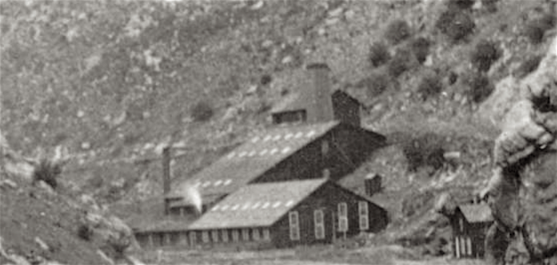 The Humphrey Mill (also called the Humphrey Concentrator) back when it was operating - note the steam exhaust from the roof vent pipe. Notice also that big square stack - we'll see more of that later. This mill apparently never received any ore shipments from the Gilpin Tram. Photo courtesy of the Mark Baldwin collection. There is not much information I could find out about this mill. The 1890 Sanborn Fire Insurance Map shows a spur from the Colorado Central 3’ gauge to this mill. The 1895 and later Sanborn maps don’t show this mill. Also, I could find no references to it receiving any ore from the Gilpin Tram or by other means. My opinion is this mill closed down probably by the turn of the century. 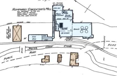 This is the 1890 Sanborn Fire Insurance map showing the Humphrey Mill. Note the 3' gauge Colorado Central spur which served the mill at the time. This seems to have a been a very active mill operation at one time 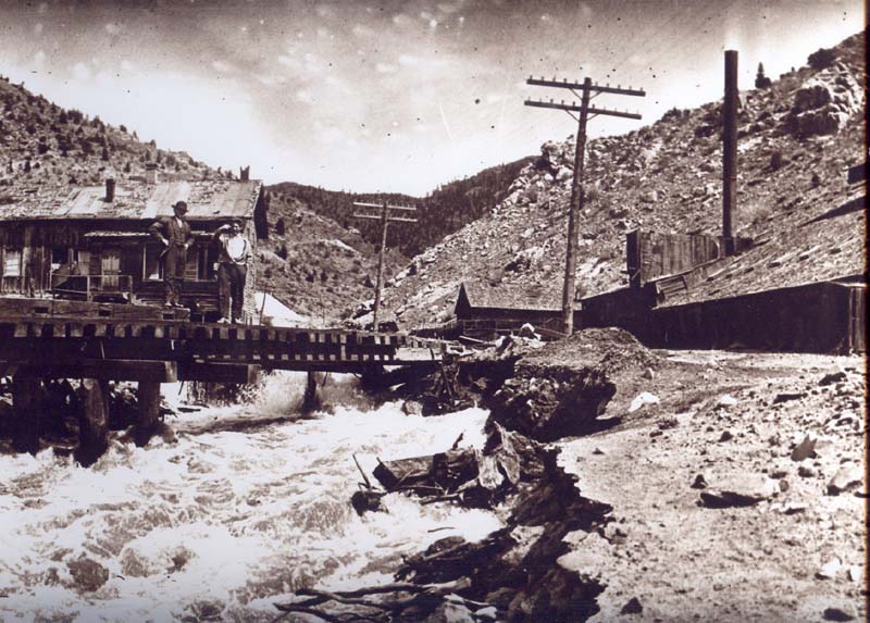 Here is a later view looking upstream at a high-water Clear Creek, with the C&S bridge. By this time, the Gilpin Tram had shut down and the 2' dual gauge removed. The Humphrey Mill is at the right hand side of this photo. The mill looks inactive, and rather dilapidated by this time. Photo courtesy of the Mark Baldwin collection. 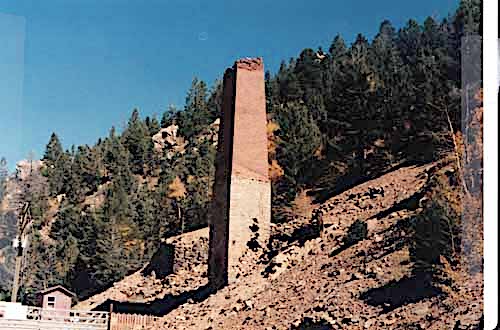 By the 1980s, all that remained of the Humphrey was some foundations and the brick smokestack (which you could clearly see in the previous photos showing the mill when operating). The City of Black Hawk chose to remove this "eyesore" sometime in the 1990s, dug out part of the hillside, and used this space for parking for a few years
Keith Pashina
Narrow-minded in Arizona |
Re: The Gilpin Tram in Black Hawk
|
|
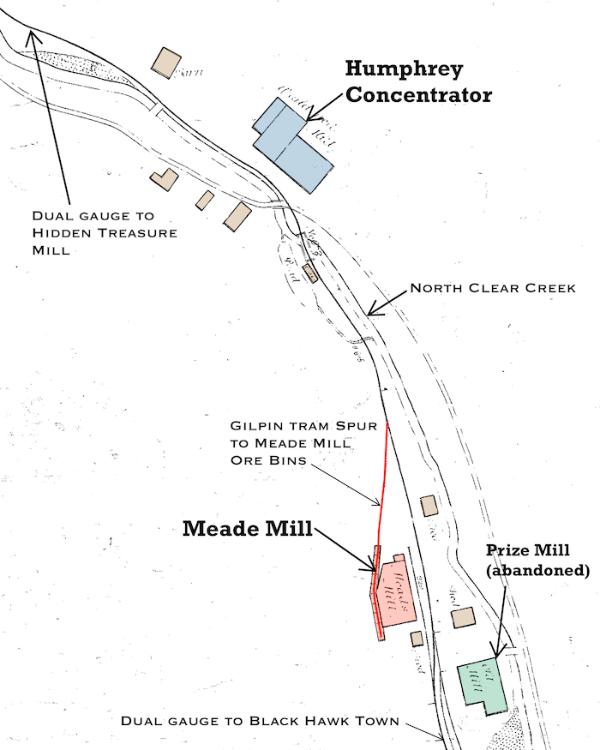 This map shows the details of the area around the Humphrey and Meade Mills Next, we come to the Meade Mill. The Meade Mill was another mill that was constructed before the railroads were built, and expanded over the years. As the Gilpin Tram was being built, the mill owners modified the mill to put metal sheeting over the wooden ore bins, and had a spur built to serve the elevated bins. This mill received the first ore loads shipped over the Gilpin Tram, from the Gunnell Mine on December 11, 11887, when six ore cars were shipped to the mill. 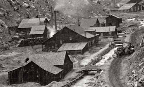 In this pre-railroad photo, the Meade Mill is the building with the smoking stack in the center of this photo. Several additions were constructed over the years on this building. This photo is from the Denver Public Library, Western History Collection, image X-60795 Another incident was reported in 1888, when a runaway ore car in what must have been an exciting accident. The runaway ore car, which had been unloading ore at the Hidden Treasure Mill, ran downgrade to the Meade Mill, where the runaway ore car struck a wooden ore wagon, demolishing it, killed one and injured the other mule, then when on to strike another GT ore car loaded with ore. This collision released the second ore car’s brakes, and the two runaway cars continued on to near the Polar Star Mill, where they struck a UPD&G 3’ gauge boxcar before everything finally came to a stop! 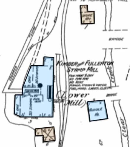 The 1890 Sanborn Fire Insurance map shows the Meade Mill. The map doesn't show it, but the Gilpin Tram spur ran parallel to the double dashed lines (water flume for water wheel) and dumped into the ore bins The Meade Mill was sometimes referred to as the Fullerton, Gunnell and Kimber and Fullerton Lower Mill as various times. The mill building housed 40 stamps, powered by a water wheel seasonally, and a boiler and steam engine the remainder of the year. There was also a separate buddle house across the tracks. 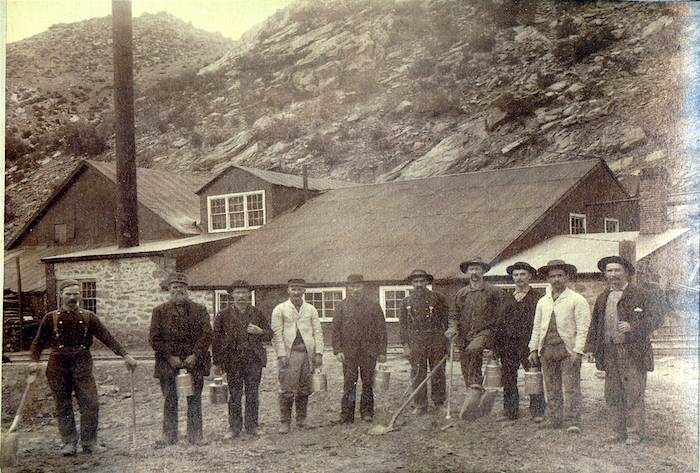 This image shows the Meade Mill, from the creek side sometime in the late 1890s and before 1902. The Gilpin Tram Era Sundance book has a series of three photos taken at about the same time showing more details of this mill. I think this would be an interesting structure to model - I like the combination of stone, wood, and metal-clad walls, and varied roof lines. Nothing remains of the mill or its site today, due to more recent highway and water drainage construction. Photo courtesy of the Mark Baldwin collection. There is a record of 27 ore cars being shipped to the Gunnell Mill in September 1906, but that could have been this mill or another operation using the Gunnell name at the time. I could not find any records of any other shipments to this mill after this date. 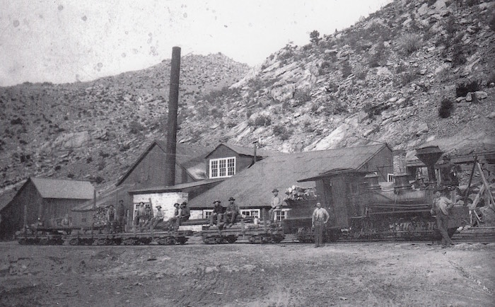 This photo is from the Gilpin Railroad Era by Sundance Publications, and shows Shay #1 and a work train in front of the Meade Mill. The Meade Mill was a conglomeration of several building styles, and would make a very appealing model As we continue our visit down along Clear Creek, we round a bend and approach a very fascinating area - the location of the transfer tracks between the Gilpin Tram and C&S, and further downstream, the Polar Star and Eagle Mills. The main part of Black Hawk becomes visible in the distance. 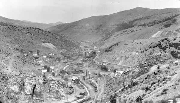 Here is a great view from the Denver Public Library, Western History Collection, showing a view of Black Hawk looking south. Lots of detail can be seen in this view 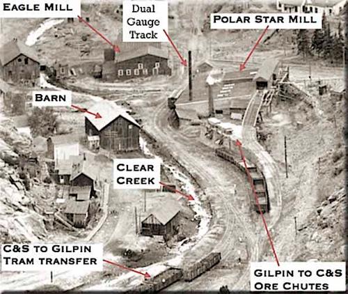 Here is a key to the photo above, identifying the areas of interest I will pause for now, but in the next posts, we will examine this area in detail. 'all for now!
Keith Pashina
Narrow-minded in Arizona |
«
Return to C&Sng Discussion Forum
|
1 view|%1 views
| Free forum by Nabble | Edit this page |