Idaho Springs Tank
12
12
|
This one is for you, John.
Harry Brunk's nice drawings of the Idaho Springs tank (or was it Georgetown?) with the cast iron columns inspired me to build one for my small layout. This was circa 1995. 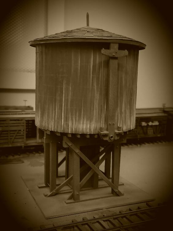 I built the barrel easy enough, but could not figure out an easy way to make the columns. Now we have 3d printing. At the time, I built up a wooden support frame, and then went on to the roof. The roof is all styrene shingles, and, as Derrel's theorem suggests, I didn't not figure out the C&S favored battens over building felt for roofing. That will be harder to fix. But, I might dig out Harry's book and make those cool columns and the strap ties.
Keith Hayes
Leadville in Sn3 |
|
Hmmm, looks to be different from the one at Idaho Springs to me {:))
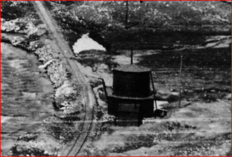 http://digital.denverlibrary.org/cdm/fullbrowser/collection/p15330coll22/id/3356/rv/singleitem ...the 2nd tank at Idaho .... 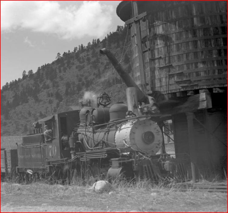 http://digital.denverlibrary.org/cdm/singleitem/collection/p15330coll22/id/42719/rec/5
UpSideDownC
in New Zealand |
|
Chris, as usual you are on SPOT for finding collateral images. My model started as the 2nd tank, of course.
Keith Hayes
Leadville in Sn3 |
|
In reply to this post by Chris Walker
Who built the castle?
|
|
Robert, you might like to read this page.
http://www.dupontcastle.com/castles/co_unk4.htm
UpSideDownC
in New Zealand |
|
In reply to this post by Keith Hayes
CONTENTS DELETED
The author has deleted this message.
|
|
This post was updated on .
EDIT:Note, this later view does not show the first tank, I have pasted it in to show location. Ahhh, holdon there, not quite succumbed to the pile, as the houses seen in the later McCure pic http://digital.denverlibrary.org/cdm/fullbrowser/collection/p15330coll22/id/90657/rv/singleitem/rec/7 are still (inside the yellow line) in existance in todays I.S. 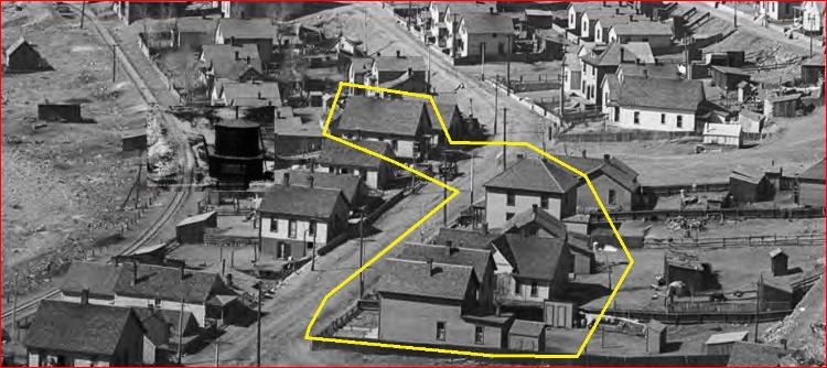 Just being picky, not picking a fight {:))
UpSideDownC
in New Zealand |
|
This post was updated on .
CONTENTS DELETED
The author has deleted this message.
|
|
Do we know the source of the water for the IS tanks? City supply or out of the creek itself or perhaps a spring? There are various examples of railroads moving structures from one place to another. Could this be the case here where the tank was relocated for some reason. Perhaps related to a supply of clean water? The water in Clear Creek west of IS was likely cleaner than the water on the east side of IS.
So, perhaps the tank was moved and reused by mounting it on the new cast support structure. Best, Todd Ferguson Harrisburg, NC |
|
The 1st IdahoW.T. in question may have had a pumphouse in the foreground shadows, there is definitely something there, at a time when there are no other buildings on that section of ground. Looking deeper into the picture it seems the roadbed was raised across an old meander or dry channel in the streambed of the Clear Creek. In that case then the water would have been taken from the Creek. Ever so slightly further West of this spot the drainage for Virginia Canyon enters the Clear Creek, this may have had a piped supply to the 1st Tank that wasn't reliable and /or constant. Speculation on my part.
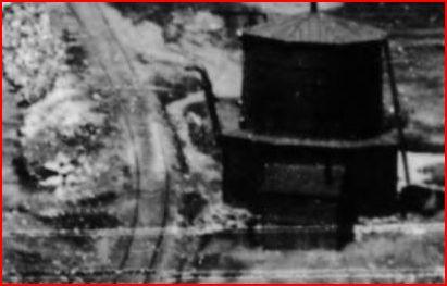 http://digital.denverlibrary.org/cdm/fullbrowser/collection/p15330coll22/id/3356/rv/singleitem In his Up Clear Creek article on the 2nd W.T. at Idaho, NG&SL Gazette Nov/Dec 84, Harry Brunk muses.... "There were at least two water tanks in Idaho Springs over the years. In the early days of the Colorado Central, there was a tank just west of the area where the Argo Tunnel was built. This tank was gone in later years but it was near enough to the Argo that I suspect that it may have been removed because it was in the way of the tunnel construction."
UpSideDownC
in New Zealand |
|
CONTENTS DELETED
The author has deleted this message.
|
|
This post was updated on .
Hang on a minute! How did you get that out of that? I'm certainly not here to tear down Harry Brunk. I merely postulated a possible reason. Mining up Virginia Canyon increased and maybe took the water supply? Seems logical to draw that conclusion after reviewing the following growth of the Newhouse/Argo. And I'm not saying I'm RIGHT either, just posting the info as I find it. The photos above (if you look deep into the links) closely show the same buildings and verified from todays views available on GoogleStreetview. I for one cannot find a photo that shows the Newhouse Tunnel Dump ever encroached on 23rd Ave. Just use streetview to see how far from the Argo Mill, 2017 Virginia St is. The 2-storey house w/attic dormer, uphillside of that address is visible in MCC-614 http://digital.denverlibrary.org/cdm/fullbrowser/collection/p15330coll22/id/90657/rv/singleitem/rec/7 which is opposite the 1st W.T. The Dump was extended East shown here in this view 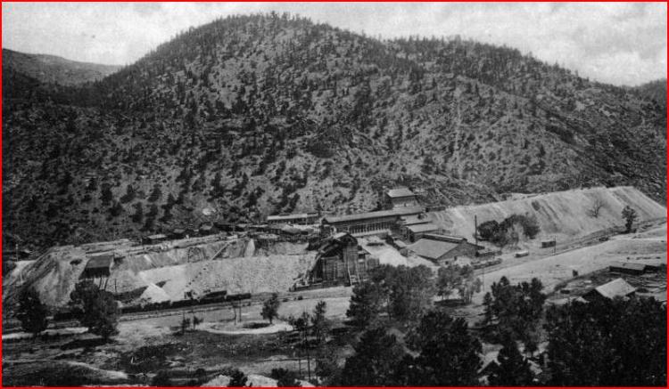
X-61683 http://digital.denverlibrary.org/cdm/singleitem/collection/p15330coll22/id/38917/rec/79 Take this earlier one so you can study the relationship of the dump size in various photos. 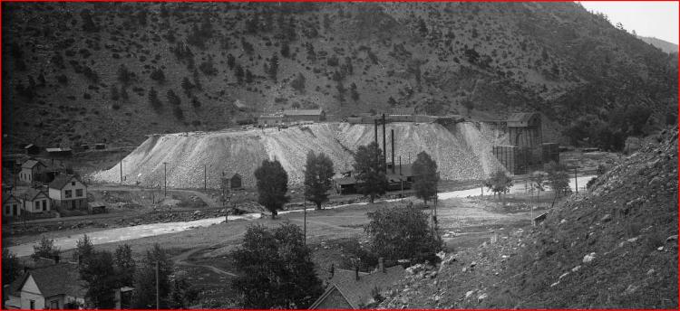 Z-2797 http://digital.denverlibrary.org/cdm/fullbrowser/collection/p15330coll22/id/67651/rv/singleitem/rec/71 In this view note the switchstand right of the houses, it still appears in the same place as in the McClure MCC-614, I doubt that siding grew any longer. Also there now are three Stacks at the Powerhouse, down to two Stacks in the MCC-614 and that the Powerhouse dissappeared in the X-61683. In this next view that shows the location of the 2nd W.T., greatly enlarged to show the relationship of the Newhouse tunnel Dump before the Argo Mill was built. This picture has a C&S "Colorado Road" lettering car in it, setting the date after 1899, (Derrell will correct me ...)  http://digital.denverlibrary.org/cdm/fullbrowser/collection/p15330coll22/id/3381/rv/singleitem/rec/2 Reading between the lines, Harry has often intimated find clues, new information, new photo's and correcting things was all part and parcel of his Gazette series "Up Clear Creek on The Narrow Gauge" e.g. read his words in part 120 Jul/Aug 2000. A footnote in regards to the Powerhouse, Harry's caption Part 17:Argo Tunnel-The Mill, photo #4 pg 58, Nov/Dec '82 pg58 "As the sign tips off: this was when everything was brand new. The purpose of the tall-stacked building lower left is unknown; it was gone in later years." From that I take it Harry was really unaware of the importance of the powerhouse and it's tall stacks as it does not appear in any of his sketches, maps or photo's presented.
UpSideDownC
in New Zealand |
|
CONTENTS DELETED
The author has deleted this message.
|
|
In reply to this post by Chris Walker
CONTENTS DELETED
The author has deleted this message.
|
|
This post was updated on .
Yes, the Powerhouse. Steam Boilers running huge Compressors to supply compressed air for the drills, air Pump (blower) for the tunnel ventilation, hence Pumphouse. Water was used in the drills after the Leyner (1897) invention.
UpSideDownC
in New Zealand |
|
This post was updated on .
In reply to this post by John Schapekahm
Actually I still don't see your arguement, the first W.T. was there on the floodplain of the Clear Creek, the Colorado Central raising an embankment across the meander. Maybe as another thought not yet put forward, the Clear Creek became angry and washed it out or undermined it? EDIT: The propensity for Cloudburst flooding in the region of Fall River/Idaho Springs was known at the time, and is documented in my thread. Here: http://c-sng-discussion-forum.254.s1.nabble.com/Castle-Eyrie-An-Oddity-in-Idaho-Springs-tp4436p18265.html 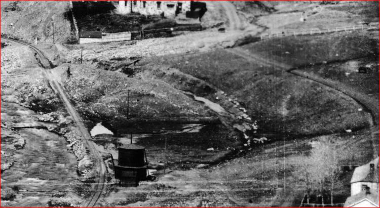 http://digital.denverlibrary.org/cdm/fullbrowser/collection/p15330coll22/id/3356/rv/singleitem This area of land was filled in and houses built upon it, as I have shown above in the DPL X-2278 picture taken from opposite the 2nd Tank location. The Newhouse Tunnel was started in 1893, in ernest by 1895 and completed by 1904. After that the Mill was built and all the waste rock was dumped along the undeveloped Eastern side of the Tunnel. Looking back at I.S. in pre-Newhouse times with the 1st Tank visible. 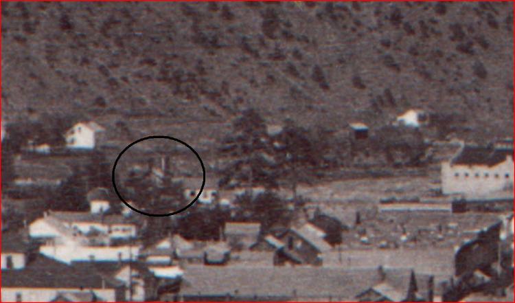 http://digital.denverlibrary.org/cdm/fullbrowser/collection/p15330coll22/id/41181/rv/singleitem In this enlargement there is no 1st Tank visible, the Wastedump appears to have reached its extent and the Argo Mill has yet to be constructed. 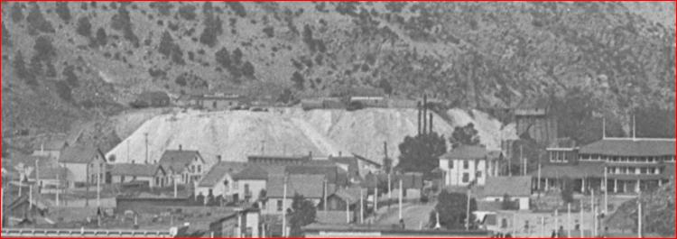 http://digital.denverlibrary.org/cdm/fullbrowser/collection/p15330coll22/id/67650/rv/singleitem Your supposition that the Argo bought off the C&S to move a Tank alongside the Railroad to possibly bury with a Wastedump when they would have just cribbed past it seems odd at the least, and I can't read that into Harry Brunk's quote above. That's a major number of houses to buy up and bury "should the need arise" as you infer. Not only that but the Tank location was 500ft past 23rdAve which is 250ft West of the Portal. Twice as much distance further in addition to what has already been dumped and after completion of the Tunnel. 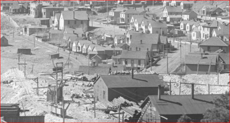 http://digital.denverlibrary.org/cdm/fullbrowser/collection/p15330coll22/id/42271/rv/singleitem And I wish to add that the Big5 Tunnel at the far Western end of I.S. didn't buy up all the surrounding houses but dumped the wasterock on the oppositeside of the valley all along the Clear Creek halfway to the confluence of Chicago Cr. I pointed out the Pumphouse in the shadow of the first Tank in my earlier post. Todd Fergusson did offer speculation, I saw no need to repeat his thoughts hence my speculation on the Virginia canyon mining, they would have needed water for their boilers until electricity arrived and I don't think for any minute the Mine drainage that you refer to would be suitable for Loco Boilers. As for the inclusion of the Argo flooding mishap you brought to the table in counter of my supposition, that is some 35-40 years after the relocating of the tank. EDIT: the Water Supply issues..... 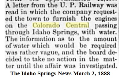 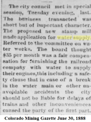 Construction of New Mills upstream(as per Todd Fergusson initial thoughts) Anderson Mill 4/1897 Jackson Mill 6/1897 Smith Mill 7/1897 + Newton Mill .....Mattie Mill(Chicago Cr.) 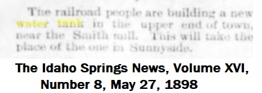 In summary I reckon that Harry got this notion from his contact in Idaho Springs of a rumour that the Argo was going to bury that housing, that was probably no more than gossip from some housewife who lived in the shadow of the overpowering dump with the fear that it would soon envelope her. How's that for thinking? It's a pity we weren't sitting around the kitchen table together and then you would hear the emphasis and tone of my voice. I think I've put up considerable visual clues to counter this, if you wish to provide same in support then be my guest, I've said my bit. EDIT: Putting paid to the notion the the Newhouse Tunnel was going to buy up the Houses to the West. note: Sunnyside was the area Nth of the tracks and East of the Virginia Canyon. 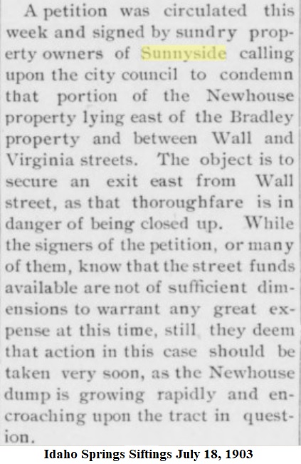
UpSideDownC
in New Zealand |
|
CONTENTS DELETED
The author has deleted this message.
|
|
Oh dear, John. I can't but help wonder if you actually read my words.
What I said there, now in bold, the key word is guessing you may refer back to original thread link if you wish. From this thread http://c-sn3-discussion-forum.41377.n7.nabble.com/Love-me-tender-With-apologies-to-Elvis-td499i20.html I can from past experience, relate a few incidents where we swapped Loco's halfway, turned and put it on the opposing train and sent it back where it came from. I was just, just wondering, not that I said so, if that could have been the case with that picture, which to me, did not fit with leaving Denver for the Clear Creek Line. From the same Nov/Dec 1982 Gazette article by Harry Brunk, here's the actual text so you can re-read it, Harry said 1904  As for the rest of your response, too many big words for me I'm afraid. Simply put, IF what you are saying about the Tank being removed/relocated for possible future expansion of the tunnel waste rock pile then please elaborate on why this area continued to have more and more houses built there and check with googlestreetview as to how many of those still exist today? The Street you want is Wall Street, that shows in the background of this next picture taken by the Natatorium. Oh look, the Tank...not many houses. 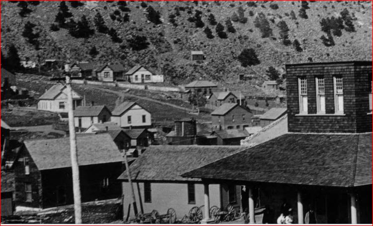
http://digital.denverlibrary.org/cdm/fullbrowser/collection/p15330coll22/id/7133/rv/singleitem Still more houses...no Tank though. 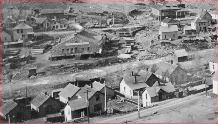
http://digital.denverlibrary.org/cdm/fullbrowser/collection/p15330coll22/id/3293/rv/singleitem And still more houses...  http://digital.denverlibrary.org/cdm/fullbrowser/collection/p15330coll22/id/90657/rv/singleitem/rec/7
UpSideDownC
in New Zealand |
|
CONTENTS DELETED
The author has deleted this message.
|
Given the nature of Clear Creek, that the roadbed at the 1st W.T. location has been constructed, on a bend from fill material with no visible defence from raging highwater in the first oldest picture, not built upon bedrock then it is not unreasonable to suggest washing out or undermining of the Tank foundations. I even found a follow on picture that includes the Tank to suggest that is not the case taken opposite the Natatorium. Those extra houses are a clue there, if I had found that picture I wouldn't have suggested a washout, yet upstream around this time a new retaining wall appears, still could be a factor. Rick or Derrell: Is there any mention of this W.T. location in the C&S inventory of 1899(?), something I've never seen to read. Yet you still cling to this idea that the Newhouse Tunnel expansion is the reason the 1st W.T. dissappeared, I am just challenging that idea, given the amount of urban sprawl in those and following years, as the wasterockpile "expansion" continued. I certainly had referred to Harry Brunk's date of around 1904 for the Tunnel completion, clearly wrote "the Mill was built between 1904 and 1910", I never thought to look in the Gilpin Era Book for anything on the Newhouse, a book that is published in 2009 vs 1982, by an Idaho Springs dwelling author vs Harry, living at the time in Nebraska. In my other thread postings I've included a number of clues to show that not all is as we seem it to be, and there are unknown reasons for that which will never be revealed. Also I really have to wonder why you expand, elevate and exaggerate my suggestions into statements e.g. "Clear Creek Cataclysm" Hmmmm. Because of this I have noticed no-one else now dares enter this particular discussion. Has anyone seen a picture of a Newhouse Tunnel Crane lifting the C&S W.T.?
UpSideDownC
in New Zealand |
«
Return to C&Sng Discussion Forum
|
1 view|%1 views
| Free forum by Nabble | Edit this page |

