Central City and Black Hawk question

Previous Topic Next Topic
 
classic Classic list List threaded Threaded
14 messages Options
Reply | Threaded
Open this post in threaded view
|

Central City and Black Hawk question

Kurt Maechner
I always assumed Central City was much higher in elevation than Black Hawk and that was why the Colorado Central needed a switchback to reach it.  Yet, I happened to notice in one of my C&S books that both towns' elevations are listed as exactly the same number.  On Wikipedia, it actually has a lower elevation for Central City compared to Black Hawk.  Can someone explain the need for the switchback?
Thanks,
Kurt
Reply | Threaded
Open this post in threaded view
|

Re: Central City and Black Hawk question

Jeff Young
I'm not sure what those sources are measuring, but the main street in Central City is definitely considerably uphill from the main street in Black Hawk.
Reply | Threaded
Open this post in threaded view
|

Re: Central City and Black Hawk question

Chris Walker
In reply to this post by Kurt Maechner
Kurt,

If you look at the Internet you get varying results depending on just where the site has placed the co-ords, one hit for Black Hawk was on the hillside above town. YMMV.

If you use Google Earth then you can establish the Elevation in that manner depending on where you place your cursor. YMMV.

If you look at Printed material such as the C&S Timetable for the line you will get what they had accepted as established by the USGS at the time of survey.  YMMV since in some places, sometimes over the years, newer surveys affected the results.

USGS Topomap printed in Mineral Belt V-III pg393
Black Hawk Benchmark 8042ft
Central City Benchmark 8422ft

CRRA #10 pg 87 (Printed Time Table: Union Pacific Colorado Central)
Black Hawk 8057ft
Cen Cty  8510ft

DSP&P pg 417 (profile)
Black Hawk 8035ft (Depot)
Cen Cty  8527ft  (EoT)

Mineral Belt V-III pg381 (Text: Personal Diary)
Black Hawk 7943ft (orig Depot) new Depot at 8035ft.

DSP&P pg 452 (Station List)
Black Hawk 8035ft (Depot)
Cen Cty  8517ft  (Depot)

Then there is this.... BTW, I haven't ever seen an actual C.C./C&S Rly elev, sign on either of the Central Depot.

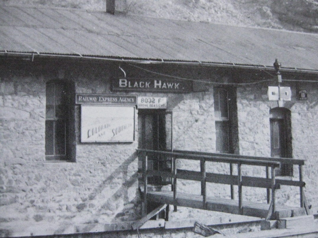
William Gibson Sr Photo Mineral Belt V-III pg387 Official C&S signage.


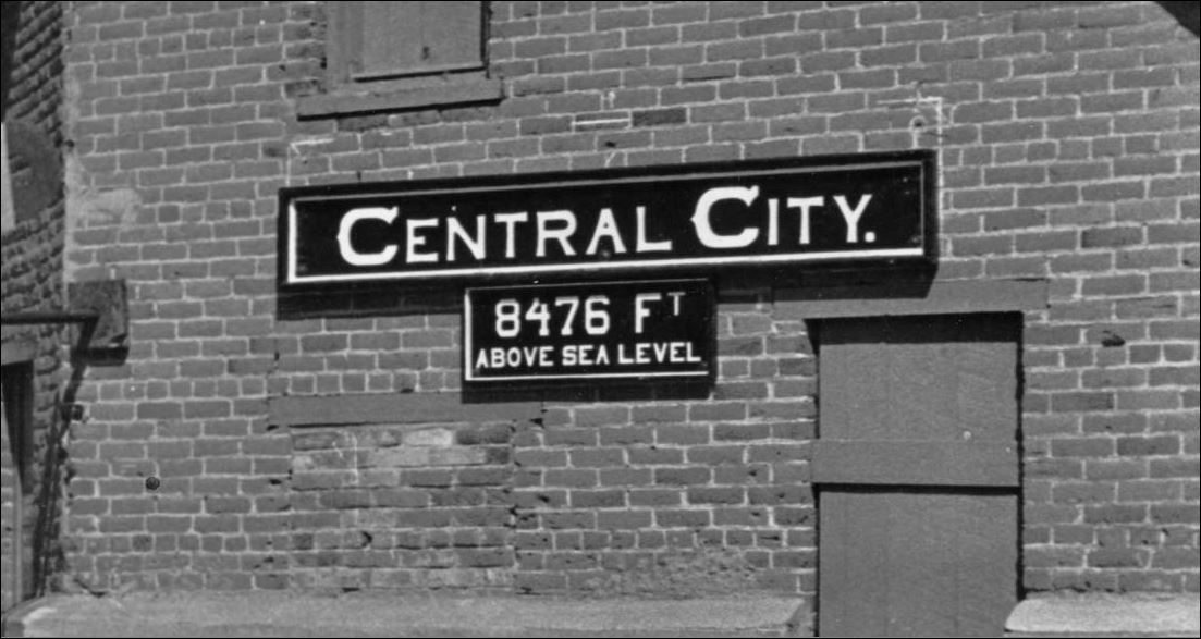
DPL X-11603 restoration signage.


You'll have to ask Rick Steele about the origins of the two Elev. Signs at the #71 display site, there was a NG&SL Gazette article about such back in the early 1980's.
UpSideDownC
in New Zealand
Reply | Threaded
Open this post in threaded view
|

Re: Central City and Black Hawk question

Kurt Maechner
In reply to this post by Jeff Young
Here are some variants I found:

The book Colorado Central Rail Road lists both towns as 8478 ft.
Wikipedia lists Black Hawk as 8537 and CC as 8510
A C&S timetable in Georgetown and the Loop lists Black Hawk as 8035 and CC as 8504

Maybe because Central City is so hilly, the elevation in the timetable is specifically related to the depot?
Reply | Threaded
Open this post in threaded view
|

Re: Central City and Black Hawk question

Kurt Maechner
Chris,
Just saw your message.  Those stats are very helpful.  I'm trying to write a piece explaining the use of the switchback and was confused by all the differing elevations, but at least the C&S documents make it clear that there was a roughly 500ish foot difference between Black Hawk and Central City.  I think what threw me off the most was the Colorado Central Rail Road book map which I would think the authors would have used railroad elevations, but apparently didn't.
Reply | Threaded
Open this post in threaded view
|

Re: Central City and Black Hawk question

South Park
  Had the South Park and Colorado Central only known that they were building
on flat ground, things might have turned out much differently for both, as operating
expenses would have surely been much less of a financial drain.  Such a shame
that this was never brought to their attention.
"Duty above all else except Honor"
Reply | Threaded
Open this post in threaded view
|

Re: Central City and Black Hawk question

Chris Walker
In reply to this post by Kurt Maechner
USGS Topo map for Black Hawk.

1906  Benchmarked  8042Ft

1942 Benchmarked  8057Ft  Note: BM has moved upstream to cnr of Blackhawk St and Clear Creek St.

USGS Topo map for  Central City.

1942  Benchmarked 8494Ft

To be compared with previous Post reference (undated) that maybe the Special 1906 for the Mining District.
USGS Topomap printed in Mineral Belt V-III pg393
Black Hawk Benchmark 8042ft
Central City Benchmark 8422ft
UpSideDownC
in New Zealand
Reply | Threaded
Open this post in threaded view
|

Re: Central City and Black Hawk question

Kurt Maechner
In reply to this post by South Park
South Park,
Agreed, it's a shame they didn't have Wikipedia to set them straight.
Reply | Threaded
Open this post in threaded view
|

Re: Central City and Black Hawk question

Kurt Maechner
In reply to this post by Chris Walker
Thanks, Chris, for those Topo map numbers and the Mineral Belt reference as well.
Reply | Threaded
Open this post in threaded view
|

Re: Central City and Black Hawk question

South Park
In reply to this post by Kurt Maechner
  You know what they say ....

"Blindsight is 20/20 !"
"Duty above all else except Honor"
Reply | Threaded
Open this post in threaded view
|

Re: Central City and Black Hawk question

Rick Steele
This post was updated on .
In reply to this post by Kurt Maechner
Kurt,

If you read the elevation signs on the depots (that were pictured) you will find that there is over 400 feet difference in the towns. Wikipedia is once again a font of misinformation. If you were a flatlander in Black Hawk and wanted to walk to Central City, you would truly appreciate the difference in elevation.

That being said, the 8,473 feet listed for Central City was raised by 20 feet to 8,496 feet by a new survey in the 1930's. Black Hawk rose 20 feet as well, but the difference in elevation remained the same.

On the Google search for Central City, the elevation is listed thus:
Central City is located in the Rocky Mountains 35 miles west of Denver. It is at the southern end of Gilpin County at an elevation of 8,496 feet.

BUT, it is also listed as 8,510 feet as well, the elevation of the old court house, perhaps?

In looking at the Google map of Black Hawk, I can see why it is listed as higher than Central City now. Black Hawk, in the past few years, has annexed a lot of property going north on Colorado 119, East, including Dory Hill and to the South. There are a lot of pointy lands in those annexations. Unfortunately, in the C&S Official Mileage Books, elevation is not listed.

The Switch Back was necessary because there was not enough room in the canyon between the two cities to put a Georgetown like Loop. Even if there was, at the time that the Switchback was built (1878), the canyon was so heavily populated that the cost of procuring the right-of-way would have been prohibitive.  The Central City, Black Hawk, Nevadaville and Russell Gulch area was the first case of urban sprawl in Colorado and at one time, for a short time, the population in this area was greater than the population of Denver. The tail track on the second switchback had about three (Passenger) cars of room. The tail of the Black Hawk end went up to the Hidden Treasure Mill which was the origin station of the Gilpin Tramway Company.

Along the line were the sidings at Running Lode and the Central City Mine as well as the Sauer-McShane Mercantile Warehouse, The Hawley Merchandise company Warehouse, the Zang Beer Distributor and the Neef Beer distributor. The Valuation map also shows a large coal dock in Central City as well as a Continental Oil Company distributor. All of the industries served, except Running Lode being in Central City proper. Of course Central City's depot had a Freight Dock because the new brick Central City Depot was built on the site of what was a wooden freight house.

FYI, at the end, When the Switchback was going to be abandoned in the late 1920's a spur track going up Gregory Street in Black Hawk was considered with a new Passenger Depot being located at Mountain City (at the base of Gregory Gulch). I have seen the drawings for the spur track, but the track was never laid and the depot was never constructed.

Rick
Reply | Threaded
Open this post in threaded view
|

Re: Central City and Black Hawk question

Dave Eggleston
Don't forget the spur used for the first coal bin in Central put in about 1878 and lasting until the late 1880s, next the south side of Hawley's. I'm not sure if any map shows that original structure, but at least one photo does. Circa 1905 that coal structure on the valuation shows up where the bins had been, serviced from the already extant passing siding next to it.

Rick, I've also noted that the spur just before the Central City mine spur, listed as spur no.1 on the valuation map, just below the East Boston, had a chute. I think it was built sometime between 1902 and 1915 based on photos. Following that chute down the slope, it appears it may have been used to feed boards to the lumberyard on Gregory. Does that sound right?

It's always fascinated me that after switchbacking so dramatically up to Central City the line ended well above the town's business core. A seemingly bad situation, for offloading there was an ingenious amount of leveraging gravity that resulted: dumping (the original coal shed), manhandling down (the later coal shed), sliding down chutes (the lumber yard, Central City mine, Sauer McShane, Hawley), rolling (barrels, visible below grade around Zang's and Hawley's) or teaming downhill. I don't know of other places like it.    
Dave Eggleston
Seattle, WA
Reply | Threaded
Open this post in threaded view
|

Re: Central City and Black Hawk question

Keith Hayes
Dave, I believe that Central City was rather mature by the time the railroad arrived. Unlike many other towns in CO-NM-UT which were created by the railroad, Central was a going place, and the CC likely got some cheap property at the edge of town and at the time not part of a mining claim.
Keith Hayes
Leadville in Sn3
Reply | Threaded
Open this post in threaded view
|

Re: Central City and Black Hawk question

Dave Eggleston
Keith, it definitely was mature, nearly 18 years old.

My point was the CCRR's difficult line into and through Central worked out well for local businesses. What was poor land for most uses was leveraged quite well for receivers of freight. I do wonder how cheaply that Central City ROW was acquired for, they had no other choices, and it certainly cost a good bit to build and a lot to maintain and operate.

Gets me wishing again that I had 20' of wall to build an HOn3 version of Central City in UPDG days.


Dave Eggleston
Seattle, WA