#9 in Dickey, and a Tale from the Past
12


12
|
Hwy 8 and US 285 follow a similar route to Buena Vista and then turn right and up to Leadville.
Some winters are not too bad, some are much worse. From a digging out perspective the last 3 winters in Como have been OK, but a friend who lives south of Fairplay, near the route they would have taken, has had to plow out regularly this winter, fortunately he has a skid steer. The County would have done something to keep the road open, but the equipment back then would have been much less capable. I can not imagine they would have gone over Hoosier and through Breckenridge. |
Re: #9 in Dickey, and a Tale from the Past
|
Administrator
|
In reply to this post by Charles McMillan
I'm quite sure he said they went over Trout Creek Pass, which would have taken them through Buena Vista. Mr Como Depot nailed it.
|
Re: #9 in Dickey, and a Tale from the Past
|
Great stories, Mike. Thanks for sharing these. I wish there was some way to collect all these anecdotes.
Kurt |
Re: #9 in Dickey, and a Tale from the Past
|
Administrator
|
This post was updated on .

|
Re: #9 in Dickey, and a Tale from the Past
|
In reply to this post by ComoDepot
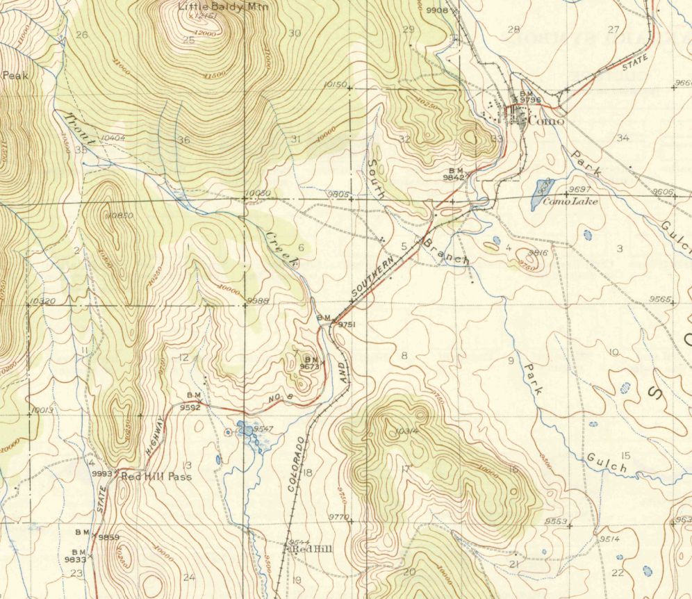
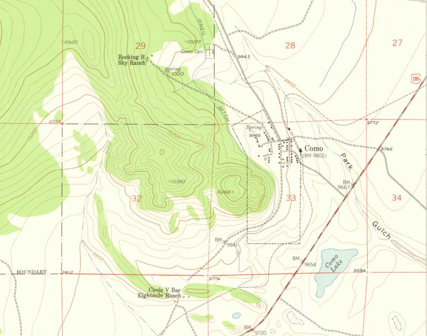
These may help. The two topo maps were downloaded from USGS, so if someone wants to take the time, there may be maps showing the whole route to Leadville. These show the area around Como.
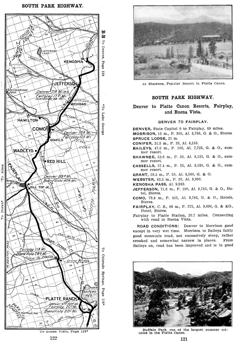
1912:  1937, showing highway 8 heading toward Fairplay:  1957, highway 8 is gone (as is the railroad), and 285 now runs south of Como: 
|
|
Todd, thanks for that.
The 1912 map shows what I understand to be the old wagon route coming of Kenosha and then does a hard left towards Jefferson, I think that originally the road carried on towards Hamilton through old Jefferson. I see Boreas is called Breckenridge Pass, seems like both terms were used, slightly surprised to it being used this late, 30 years after it was renamed. Hamilton is mentioned, I did not think there was anybody there at this time. O'Neils seems to be near the lower water tank. Wadleys I have not heard of, there is an old ranch in that area. US285 is further to the west of Antero, not sure why there is that loop there. The 1957 map shoes the old road into Como from US 285 at the top, the new one at the bottom I think was very new, I have spoken to people who remember coming in on the old one in the 50's, latter the turn was moved a couple of hundreds to the south so now there is a kink. |
Re: #9 in Dickey, and a Tale from the Past
The 1912 map is a strip map from a set that was sold page by page on eBay. I only got a few pages. From what I understand from the eBay listing, these were intended for early motorists to navigate their way using whatever roads were available, many of which would have been wagon roads. The facing page had notes about the conditions. Unfortunately, the facing page was the back of the previous map page, so I'd need to buy that map to get the notes, and it wasn't always clear which map that would be. In this case, I think the previous page covered from Morrison to Kenosha, and I have that map as well, so I have at least most of the notes for the South Park map. |
Re: #9 in Dickey, and a Tale from the Past
|
Interesting to me from the 1912 map the availability to get gas and oil along the route in many places.
if folks have other sections of this map it would be great to see them, put in archive? Al P. |
|
The very early maps show the road from Kenosha to Hamilton as a straight line with Jefferson about half way, seems Jefferson moved maybe for the 3rd time when the Railroad came through, also would explain why the Depot was built later. It would make sense for the road to originally have gone down the draw from the top of Kenosha, much more obvious route.
When I say road I assume it was the same as are shown in the early photos of Como, more of a trail. |
Re: #9 in Dickey, and a Tale from the Past
|
In reply to this post by Todd Hackett
Could the bridge north of Antero reservoir referred to on the 1912 map be the old one still standing near present 285 highway?
|
|
I had assumed that bridge was from a later period, I assumed that in the early days bridges were more horse focussed and that looked like a bridge built well after WW1, can not imagine there was much money up here for that sort of thing at the time?
|
Re: #9 in Dickey, and a Tale from the Past
|
This subject is fascinating. I am left with similar questions about the route
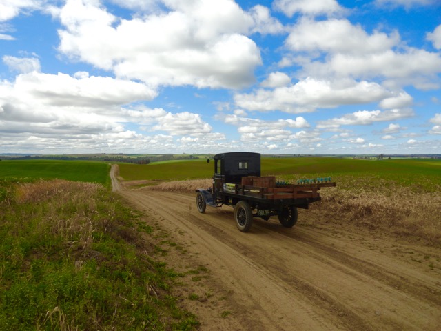
and time it took to make the trip. I drive a 1925 Model T. I intimately know HOW they drive and the roads they were built to be driven on ... basically deeply rutted/rough wagon roads. There were no highways like we generally think of them today. The through roads went from town-to-town, ranch-to- ranch, with an endless gamut to run of tee's and wyes in which to befuddle those unfamiliar with the route. The photo above, taken at Shawnee, is exemplary of what pre-war motorists had to deal with. Wonderful, delightful roads to drive and explore, if the weather is good and there is no pressing need to reach a desti- -nation. Getting aroung the Mosquito Range is no short run today. How they made it around that obstacle, over all those miles, those roads, in the weather that the high country often throws at you ... and to do it in a pre-war type motor vehicle ! Wow. 
"Duty above all else except Honor"
|
|
There was mention that Brownie Anderson bought a 1935 Chevrolet from the Garage in Fairplay, could not work out if it was a new 1935 or be bought it in 1935, I seem to recollect there were 2 car dealers in Fairplay, not sure if there were any in Como, never came across any.
Makes me wonder how they could afford a car, I thought it was more a hand to mouth type of existence, not much work to be had. I did speak to Bon Osier's son a few years back, not sure if he still around, he had a place over by Jefferson. I assume he was born about 1930, his father went into the trucking business after the Railroad and he went with him at times bringing up supplies from Denver, he made it sound quite a journey. |
Re: #9 in Dickey, and a Tale from the Past
|
How long was the Stone Garage in business?
|
|
I do not know when it became a Garage, gone by 1941.
I am assuming the businesses in there before did not survive the early 1910's but I have never found a good source. Luncheon counter, Pharmacist and Pool Hall right to left. |
«
Return to C&Sng Discussion Forum
|
1 view|%1 views
| Free forum by Nabble | Edit this page |

