Proof that not only the Eating House was built on stilts at Forks Creek.
123456


123456
Re: Proof that not only the Eating House was built on stilts at Forks Creek.
|
In Oct. 1902, a 110-foot spur for handling fuel oil was constructed inside the Forks Creek wye near the water tank. From what I can tell it was located along here:
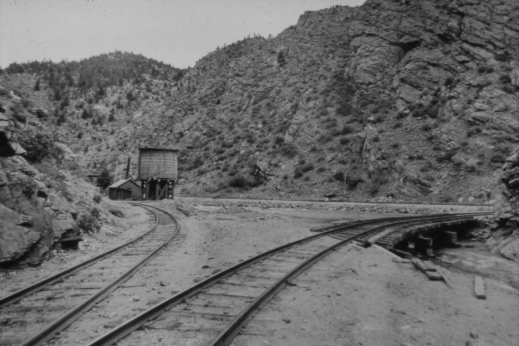 This was in anticipation of the 1903 season of Oil Fired Moguls. Two flat ng cars, 1055 and 1066, were converted to tank cars and used as fueling stations for the moguls. (And 12 SG cars were purchased to transport oil from Texas - 950 -951).This spur was to facilitate those cars on the CC line and it is thought they would have expanded the service to Platte Canyon as well. The 1903 season never happened (well it sorta happened in 2006). The price of oil skyrocketed and the economy of oil was gone. So when the summer of 1903 came the oil jets were never put back into the fireboxes (they had been removed for the winter months of 1902/03). This is based on the C&S files at the CRRM and Hol Wagner's research (and perhaps a little dot connecting on my part). |
Re: Proof that not only the Eating House was built on stilts at Forks Creek.
|
In reply to this post by John Schapekahm
CONTENTS DELETED
The author has deleted this message.
|
Re: Proof that not only the Eating House was built on stilts at Forks Creek.
|
In reply to this post by John Schapekahm
Thanks to all of you for posting these wonderful photos. All but one are new to me.
The image of C&S #21 at the Depot (I think it is c 1912-15 due to the steel pilot beam and "Como" spark arrestor) is particularly useful to me. Jim
Jim Courtney
Poulsbo, WA |
Re: Proof that not only the Eating House was built on stilts at Forks Creek.
|
In reply to this post by Derrell Poole
CONTENTS DELETED
The author has deleted this message.
|
Re: Proof that not only the Eating House was built on stilts at Forks Creek.
|
Harry Brunk wrote at least one article about rebuilding Forks Creek on his layout after he found photos and info about the back side of the buildings.
|
Re: Proof that not only the Eating House was built on stilts at Forks Creek.
|
Doug has another colour view taken just downstream opposite the rockwall where the Depot and Eatinghouse was, come on Doug don't hold out on us {:))
UpSideDownC
in New Zealand |
Re: Proof that not only the Eating House was built on stilts at Forks Creek.
|
In reply to this post by Derrell Poole
Where do you think the switch was Derrell? On the Main or off of the Wye leg?
UpSideDownC
in New Zealand |
Re: Proof that not only the Eating House was built on stilts at Forks Creek.
|
Don't know. The description only says near the water tower. The view is my best guess.
|
Re: Proof that not only the Eating House was built on stilts at Forks Creek.
|
In reply to this post by Derrell Poole
CONTENTS DELETED
The author has deleted this message.
|
Re: Proof that not only the Eating House was built on stilts at Forks Creek.
|
This post was updated on .
In reply to this post by Chris Walker
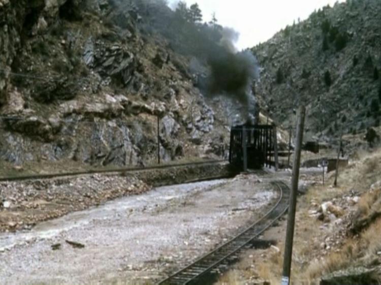
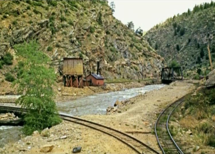
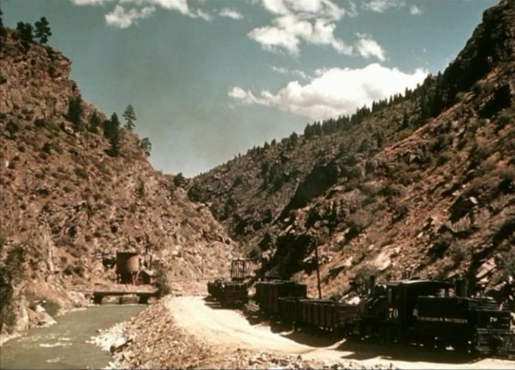
Here are a few more Forks Creek pics - circa late 1938 - 1940
   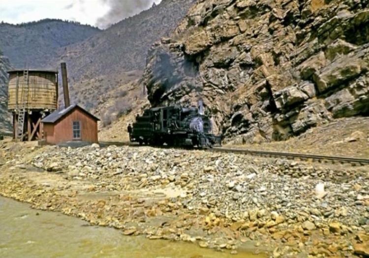
Doug Heitkamp
Centennial, CO |
Re: Proof that not only the Eating House was built on stilts at Forks Creek.
|
Thanks Doug, your date must be off a bit I can't see a shingled roof in your top photo, one that was visible in the Otto shot (3rd post in this thread) taken April '41. By the way I read your blog about building F.C. to Blackhawk and remember another shot you have, you're still holding out on us, haha! {:))
UpSideDownC
in New Zealand |
Re: Proof that not only the Eating House was built on stilts at Forks Creek.
|
Chris,
I think you are right, 1941 sounds more like it. Quite a few of the color pics I got are dated as 1938/39/40. Too early based on other known pictures. I think the only other color pictures of Forks Creek I have are these… 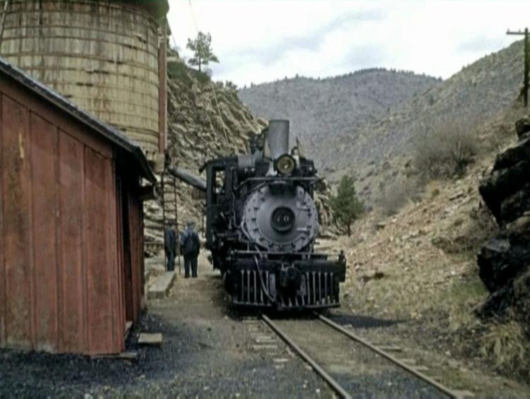 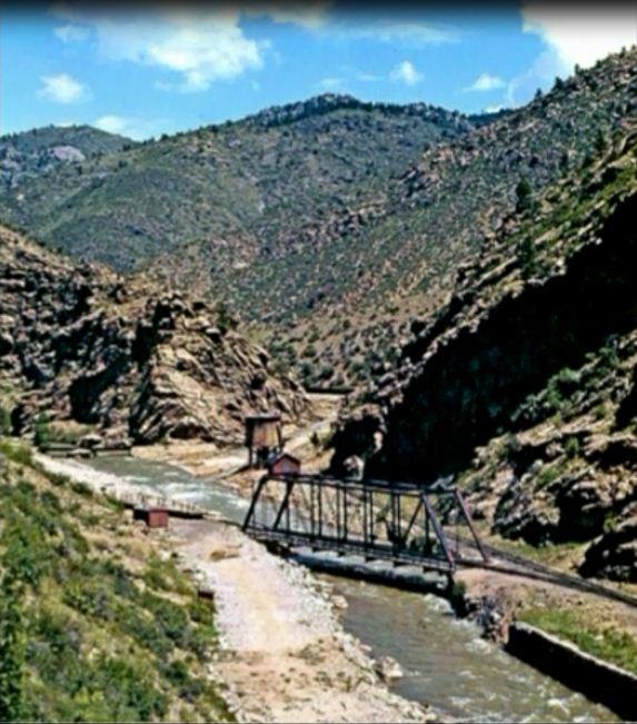 Doug
Doug Heitkamp
Centennial, CO |
Re: Proof that not only the Eating House was built on stilts at Forks Creek.
|
Ah, Beauty Mate, that 2nd shot was the one......
One thing left to puzzle is why the F.C. Depot lasted so long, just what need was there for it?
UpSideDownC
in New Zealand |
Re: Proof that not only the Eating House was built on stilts at Forks Creek.
|
CONTENTS DELETED
The author has deleted this message.
|
Re: Proof that not only the Eating House was built on stilts at Forks Creek.
|
Fascinating thread on Forks Creek, great photos. Still trying to familiarize myself with C&S locations and routes. Took my Dad up to the Loop to ride the train several summers ago and we came back thru Golden via Rt 6. Nice drive, would we have passed through the Forks Creek location?
Again, wonderful thread... Mike |
Re: Proof that not only the Eating House was built on stilts at Forks Creek.
|
In reply to this post by Doug Heitkamp
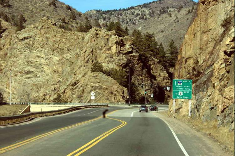
Here is Forks Creek a couple of years ago……
Doug Heitkamp
Centennial, CO |
Re: Proof that not only the Eating House was built on stilts at Forks Creek.
|
In reply to this post by John Schapekahm
Here is another view of one of the excursion cars with end windows: 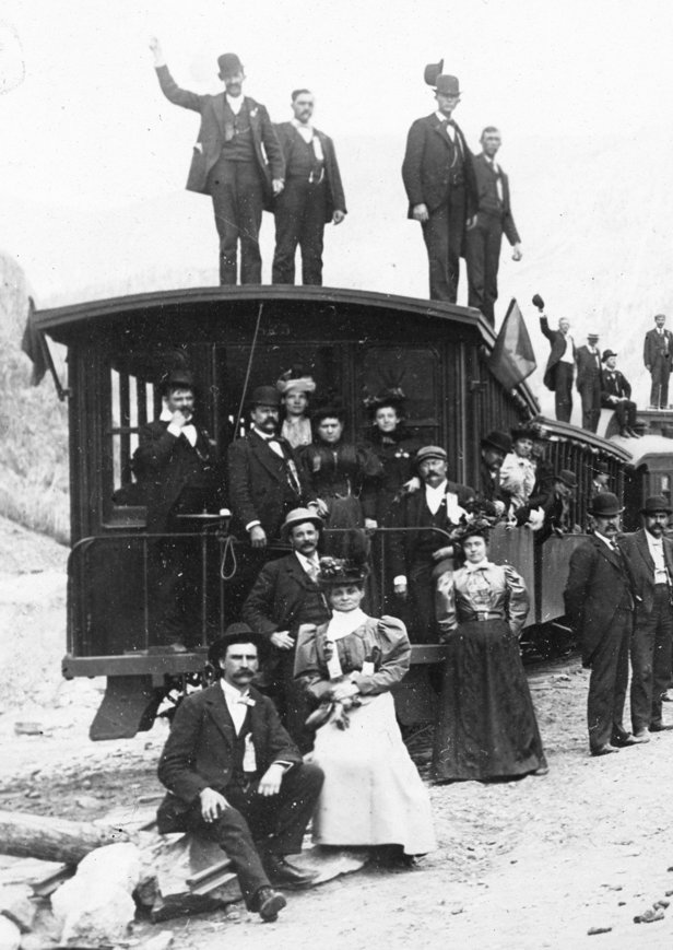 In an enlargement, you can see that it still had rolled up awnings on the side windows. 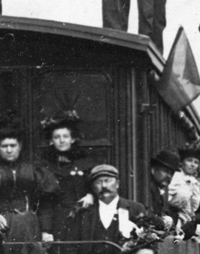 The car number is 825, which was built by the UP in 1883 as Colorado Central no. 18, according to the UP 1885 renumbering list. This comes from a photo of a large excursion that had at least four trains. I have two photos from this trip, both taken at the High Bridge. The close-up of the excursion car comes from a view with the trains headed upgrade. The following view shows them headed down. It looks like they had at least 4 trains. The photos are identified as taken by F. E. Post, and from his studio address on the back, the date is between 1893 and 1901 according to the Biographies of Western Photographers. All visible lettering and numbers are for DL&G and UPD&G, so it's proably before 1899. Locomotives include no.s 7, 112, and 26? (which looks to be a Rhode Island). Excursion car 825 is the only car with a legible number, but there is one coach lettered for UPD&G and a combine lettered for DL&G. The only information (other than the photographer) is "Wanamaker 3376." This may have been an excursion of employees of the Wanamaker department store chain. 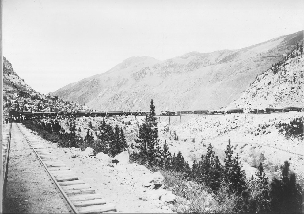
|
Re: Proof that not only the Eating House was built on stilts at Forks Creek.
|
Doug, your photo then is looking railroad west, correct? To the right is Blackhawk, etc. and to the left is Georgetown, etc. The depot would have been on the north bank of Clear Creek. Just getting it all clear in my head...
Thanks, Mike |
Re: Proof that not only the Eating House was built on stilts at Forks Creek.
|
In reply to this post by Todd Hackett
The photo over the Bridge is one of the most astonishing I've seen, Todd. Thanks.
|
Re: Proof that not only the Eating House was built on stilts at Forks Creek.
|
In reply to this post by Mike McKenzie
Dougs recent photo was taken westbound (railroad and highway). As the signs say, Blackhawk is to the right (or straight) and Idaho Springs (and therefor also Georgetown) is to the left. The depot would have been just to the left of the photographer, on the north side of the creek (really more the east side in that location). Here's a then and now using Doug's photo and a postcard photo taken from about the same spot. The old photo was probably taken from about where the station platform had been. 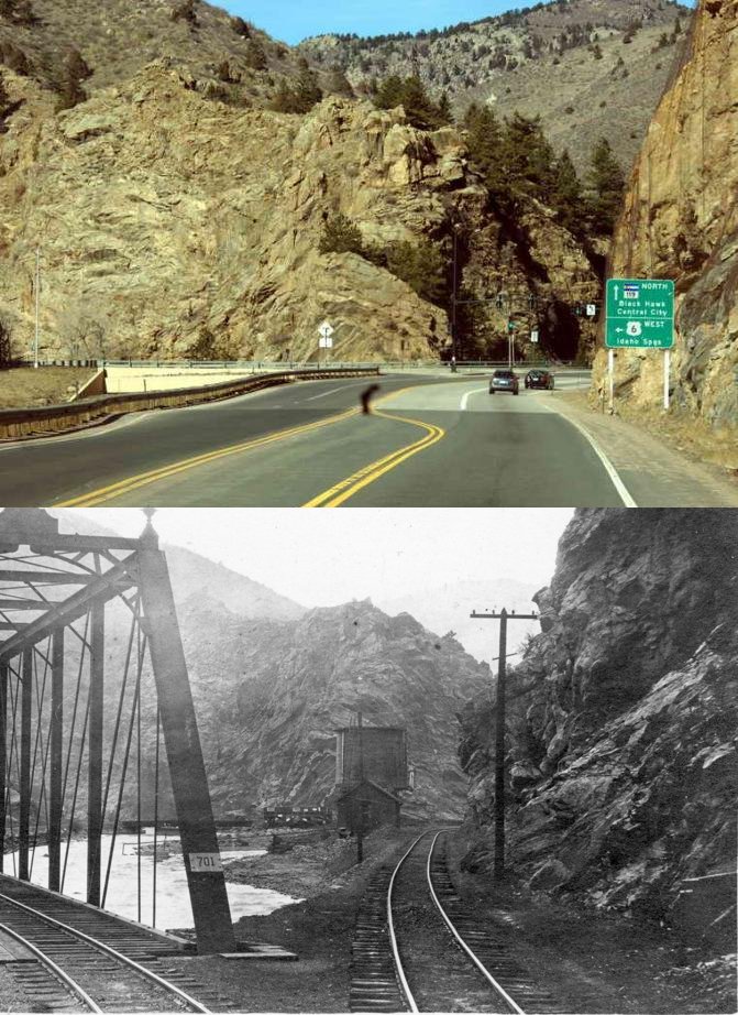 Here's the whole photo: 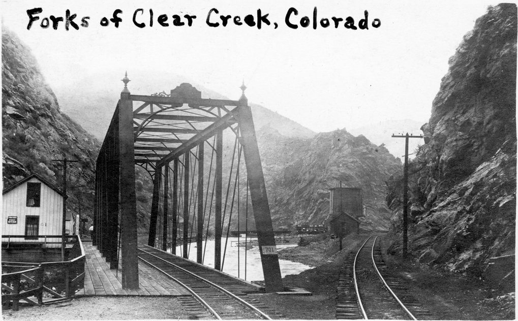 And for John, here's a close-up showing that the section house is now the post office. Also notice the Jefferson County sign. This seems to be misleading because while it appears to be in Jefferson County it is near the point where one would enter Clear Creek County. The photographer was in Jefferson County (as were the depot and lunch room), the Clear Creek County line is just past the section house according to the ICC map, so the section house and bridge are apparently in Jefferson County. The tracks heading toward Black Hawk are still in Jefferson County (entering Gilpin County just out of the photo), but the bridge over the north fork (behind the water tank in this photo) are in Gilpin County, and it appears that hthe small loading dock on the back of the wye (to the left of the water tank) is also mostly in Gilpin County. 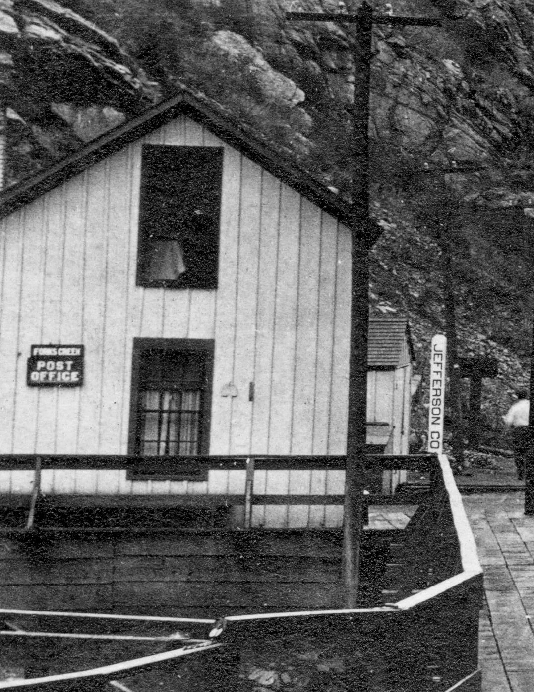
|
«
Return to C&Sng Discussion Forum
|
1 view|%1 views
| Free forum by Nabble | Edit this page |

