Blackhawk Boston & Colorado Smelter description - 1877
Blackhawk Boston & Colorado Smelter description - 1877
|
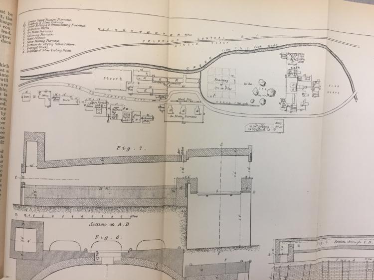
While wandering the stacks at the Seattle Central Library I came upon the Geologic Survey's annual mineral resources reports. Curious, I thumbed through the earliest volumes and in the 1875 report (printed in 1877) is a lengthy description of the processes of Professor Hill's ground-breaking and physically huge smelter in lower Blackhawk. Inserted in the report is a map of the smelter itself, showing the CCRR main and the spur into the smelter. Each building is listed with function. Handy reference material for deciphering the photos in various publications, in particular Abbott/McCoy/McCleod's Colorado Central Rail Road, pages 210, 211 (lower photo on 211 shows the spur, not the lead to the depot, I believe) and especially page 244 looking down on the works which appear to have expanded in the ensuing 2-3 years after the map was made.
After Hill moved the works to Argo in 1878 the area became home to the Randolph and the Public Sampling Works. I took a quick snapshot given I was running out of time, so I apologize for the quality. Hopefully this will be exciting to those early CCRR fans out there. I hope to get back and take a clearer photo for my records of the map and the full report but for now I wanted to see if this is something anyone has stumbled across before. Sure would be nice if the map had included more of the area, including the CCRR station in Fitzpatrick's Folly. 
Dave Eggleston
Seattle, WA |
Re: Blackhawk Boston & Colorado Smelter description - 1877
|
Neat stuff -- thanks for sharing.
Bill Uffelman
|
«
Return to C&Sng Discussion Forum
|
1 view|%1 views
| Free forum by Nabble | Edit this page |


