Another "Where Is This" Picture
12


12
Another "Where Is This" Picture
|
Group,
I'm asking because I don't know where. This is another picture I got from Robert Grandt and he didn't know either. Best guess so far is somewhere along Clear Creek. Anybody know? Doug 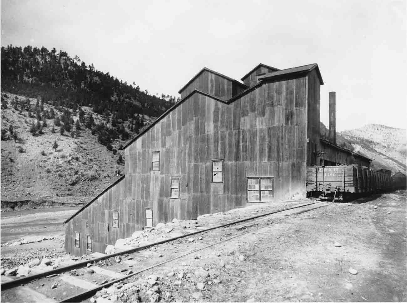 And here is the cropped close-up of the St. Charles Coal Cars…. 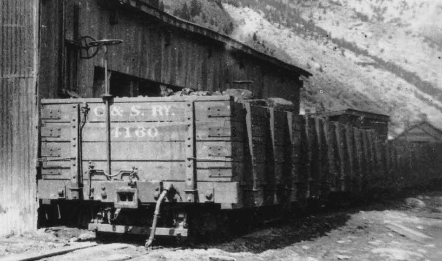
Doug Heitkamp
Centennial, CO |
Re: Another "Where Is This" Picture
|
Notice the "automatic"link and pin coupler.
|
Re: Another "Where Is This" Picture
|
This is the Mill where the Idaho Springs Section House/2nd Water Tank/Lumber Yard were at, known as the Bertha, or the Alpine Concentrator.
It subsequently burned as it is missing from a later view on pg314 in the Mineral Belt vol-3. 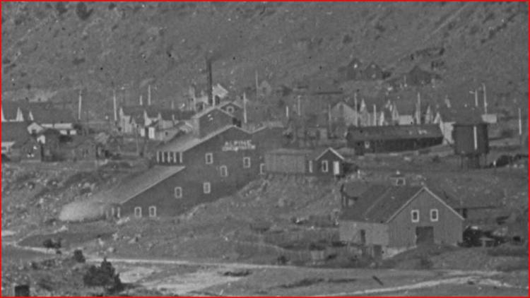 http://digital.denverlibrary.org/cdm/fullbrowser/collection/p15330coll22/id/67645/rv/singleitem/rec/24 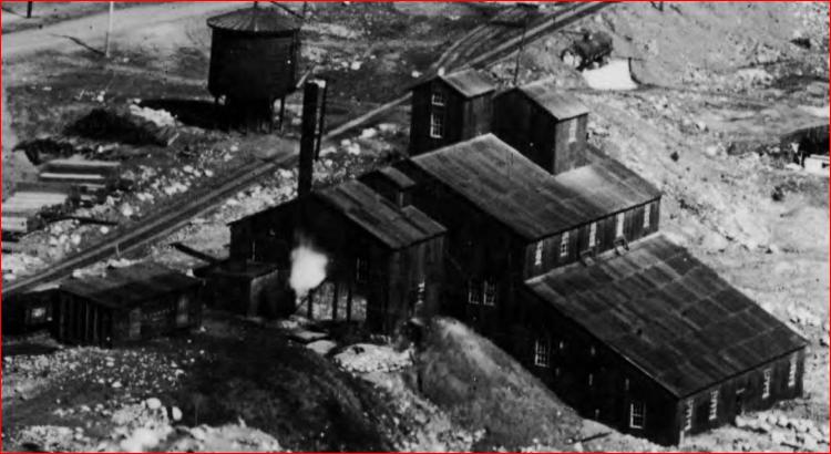 http://digital.denverlibrary.org/cdm/fullbrowser/collection/p15330coll22/id/3381/rv/singleitem/rec/2
UpSideDownC
in New Zealand |
Re: Another "Where Is This" Picture
|
Chris,
Well, that was too easy - Thanks! Doug
Doug Heitkamp
Centennial, CO |
Re: More on the Bertha/Alpine Concentrator.
|
This post was updated on .
Doug,
thank you and very much also to the late Bob Grandt for this picture. Since the close up from Roper's Blog showed the Chute-gate I wondered if it was the Bertha/Alpine, the ridgeline drew me to Idaho almost immediately, but like I've said in a few post's, just a matter of time before the missing piece of the jigsaw-puzzle fits. The Bertha Gold Mining and Milling Co were also active at two other places in Idaho, slightly downstream from the original resting place of the C&S#60 and also at the Newhouse Tunnel (later better known as the Argo).
UpSideDownC
in New Zealand |
Re: More about the Smith/Bertha/Alpine Concentrator.
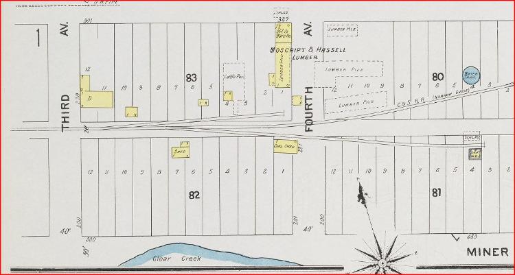 DPL called out this Mill as the Bertha in this photo. However the Alpine Concentrator lettering is not always present on the side of this huge building in later views. http://digital.denverlibrary.org/cdm/fullbrowser/collection/p15330coll22/id/3381/rv/singleitem/rec/2 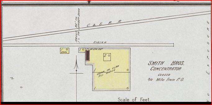 This Mill, in my initial post above I stated that "It subsequently burned as it is missing from a later view on pg314 in the Mineral Belt vol-3." Confirmation here of that speculation. http://libcudl.colorado.edu:8180/luna/servlet/UCBOULDERCB1~21~21  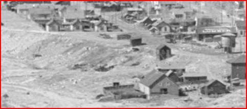 http://digital.denverlibrary.org/cdm/fullbrowser/collection/p15330coll22/id/1428/rv/singleitem In the Historical Society of Idaho Springs, book "A History of Clear Creek County" 2004 pg98, can be found a view (dated 1890) of similar perspective to Robert Grandt's Title picture at the top of this thread but with the addition of the long orebins facing the Siding as shown in this view.  http://digital.denverlibrary.org/cdm/fullbrowser/collection/p15330coll22/id/67645/rv/singleitem/rec/24 Like the Title photo showing the earlier building with a St Charles Coalcar, this purported 1890 photo shows a Coalcar, but with a Knuckle coupler visible. I wonder if the "Locality" or the Siding was also known by the name "Smith Mill" as it was still called that in the 1922/1929 C&S trackage map of Idaho Springs shown on pg213 CRRA#10. The siding was still present at the "Last Train" photo by John Maxwell also on pg198 (middle) of N.G.to Central & Silver. Finally there was a newer Mill built here in the last years of the C&S visible in the background of this photo. No name at this writing found. http://digital.denverlibrary.org/cdm/fullbrowser/collection/p15330coll22/id/38790/rv/singleitem/rec/1 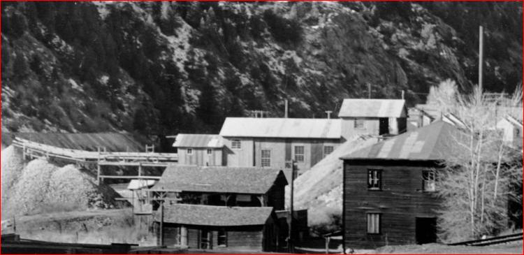
UpSideDownC
in New Zealand |
Re: Another "Where Is This" Picture
|
In reply to this post by Robert McFarland
Robert, the "automatic" link and pin looks a little like the Sam's Patent used on the F&CC Gon's.
|
Re: Another "Where Is This" Picture
|
Rick,
Described in CRRA#12 pg183..... Cars to be stencilled at each end with the words"Selden Automatic Coupler"(this was a link&pin coupler with draft gear and a pin lifter).... is that what "Sam's Patent" is about as I have seen references to both over the years.
UpSideDownC
in New Zealand |
Re: Another "Where Is This" Picture
S. C. Sams and Samuel Shelden each had similar patented automatic link and pin couplers. See the patents for Sams and Shelden. Note that it is a Sams' coupler, not Sam's. The main difference between Sams and Shelden appears to be how the pin was supported prior to coupling and how the pin on the other coupler held the link in the correct position (Sams with wings on the side of the pin, Shelden with a notch in the back). |
Re: Another "Where Is This" Picture
|
Further digging into photos looking for this Mill and adding to the general cloudiness of Clear Creek,
 http://digital.denverlibrary.org/cdm/fullbrowser/collection/p15330coll22/id/3356/rv/singleitem this view DPL dated 1884 shows a Mill of very generous proportions in this vicinity, not appearing on the Sanborn Maps until 1895 and then as the Humphrey Mill. 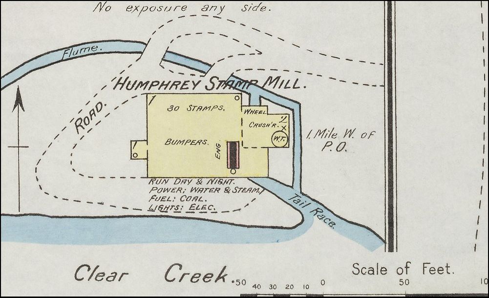
Further to this vagueness is no drawn proximity to the Colorado Central tracks that show on all other parts of the maps. The Stone outcropping on the lower ridge behind also confirms the location but the Chamberlain Sampling Works is not present in this view. I have a nagging feeling from all this that the Alpine/Bertha/Smith may just well be a different beast altogether, nothing correlates the other.
UpSideDownC
in New Zealand |
Re: Another "Where Is This" Picture
More digging supports that "nagging feeling" the Humphrey was a predecessor, note three Cottages (circled) that are present in the second picture and survive still by the time of the third picture, Chamberlain in circle on right. The Humphrey Mill should not be confused with the Big5 Tunnel started in 1900 (or 1906 depending on the source), the Big5 powerhouse later appears in the general area as the Humphreys appears to be in the first picture of the preceeding post. The Sanborn Map lists the Humphrey as 1 mile West of PO, which at that time was in the 3rd building short of the Brunswick Flats which still stands today. Googlemaps puts the 1 mile mark at the I-70 underpass by the Big5 tunnel portal. NOTE: I base this on Sanborn maps 5 year intervals as archived in the http://libcudl.colorado.edu:8180/luna/servlet/UCBOULDERCB1~21~21 whether maps were produced every year I don't know, I doubt the growth was there to support a lesser period than 5 years. Before Bertha/Alpine built. Post Humphrey. Elements in this picture date around 1890-95. 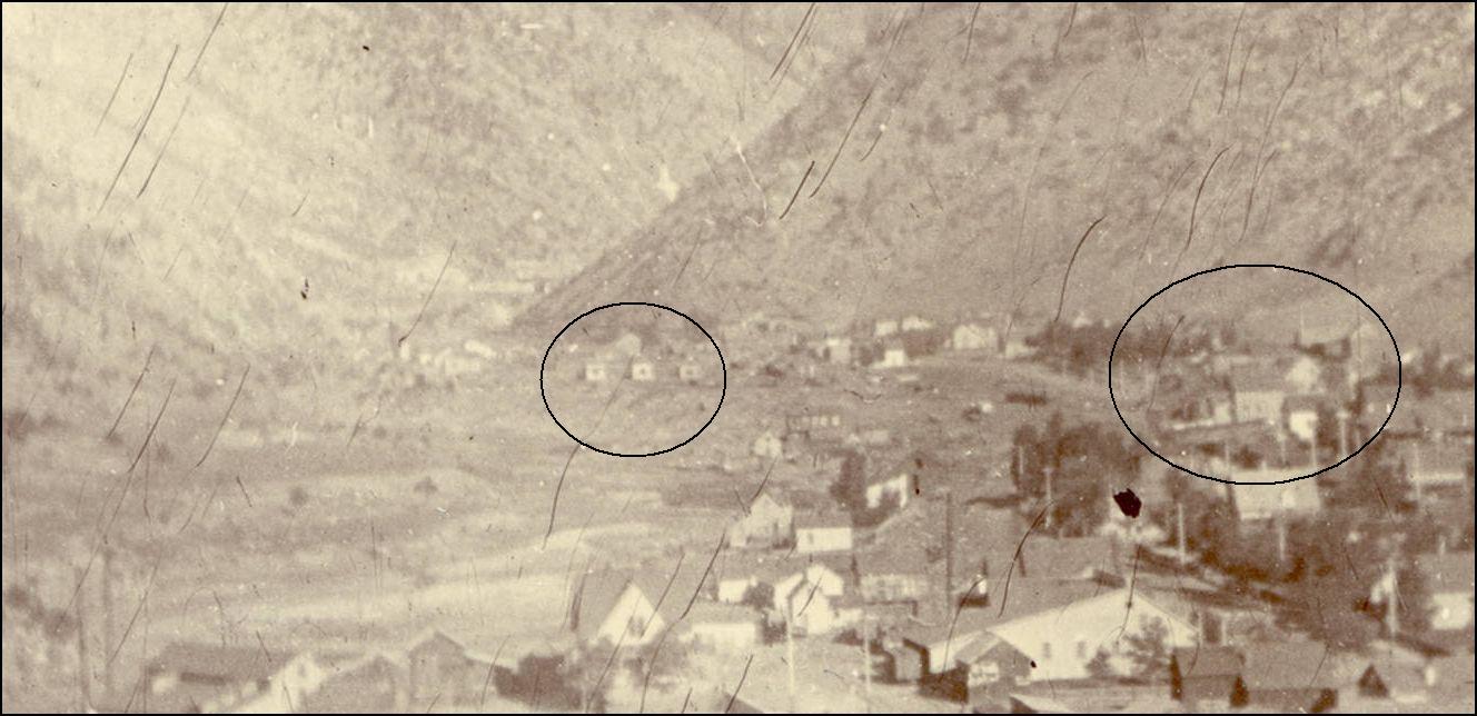 http://digital.denverlibrary.org/cdm/fullbrowser/collection/p15330coll21/id/11921/rv/singleitem  http://digital.denverlibrary.org/cdm/fullbrowser/collection/p15330coll22/id/67645/rv/singleitem/rec/24 After the Alpine/Bertha burned.  http://digital.denverlibrary.org/cdm/fullbrowser/collection/p15330coll22/id/1428/rv/singleitem/rec/24 An aside to this, the Silver Tank at the Oil Siding shows up clearly.
UpSideDownC
in New Zealand |
Re: Another "Where Is This" Picture
|
I have to say, Chris, you have certainly brought Idaho Springs to a better level of understanding. If someone wanted to do a TOC (or nearly any period of) of Gritty Switching Layout Idaho Springs would certainly be a worthy subject.
The second photo seems to date from around 1905. When I poll up the link none of the DPL data comes up - not that it matters. In the lower right is what appears to be a Type I coal car built in 1902. It looks to have knuckle couplers (I don't think the Type I cars ever had anything but). I don't see any cars with the Block lettering though there aren't very many cars visible to begin with. If you hang out at the State Ore Sampling Co. you will see at least a couple of "teams" and a few dogies... Lots of truly interesting - eclectic - detail. Wow! |
Re: Another "Where Is This" Picture
|
I agree Derrell, aside from Golden, Idaho Springs and Black Hawk were the two largest yards and thus the largest shippers on the Clear Creek lines. Either Idaho Springs or Black Hawk with both gauges would make fascinating layouts in themselves, if you had the room....
Rick |
Re: Another "Where Is This" Picture
|
This post was updated on .
Derrell and Rick hit the nail on the head.
We all tend to think of the narrow gauge as being a canyon serpent, sure there is plenty of that from Floyd on down to Golden or a mountain pass mauler, not a heavily populated urban back-alley dweller more suited to "back East" and the wide gauge. Blackhawk and Idaho are inconcruous with our preconceived notions, "gritty" as Darrell likes to say. Harry Brunk obviously recognised this years ago but he was severely constrained by the expansiveness of I.S. The amount of switching possibilities in I.S. are tremendous as the last "Mills" episode will show. I often find looking hard into these views, they may seem to be irrelevant but they contain subtle clues to our questions, I have alluded to this a number of times in my posts hoping you the reader, will jump on in and play "Spot the Twist". There have been a couple in this post, any takers? Stay tuned, there are a couple of surprises and a reaffirmation of beliefs, these things take awhile to lay out and correlate, given just as soon as one thinks it is complete, another detail pops out requiring a rethink. e.g. the Bertha and Humphrey had very similar outlines just to throw the curve ball. p.s. When I put in these links to the DPL, they go to the full-browser, at the top right there is a"close x" button, ckick that will lead you back to the Item Description Data.
UpSideDownC
in New Zealand |
Re: Another "Where Is This" Picture
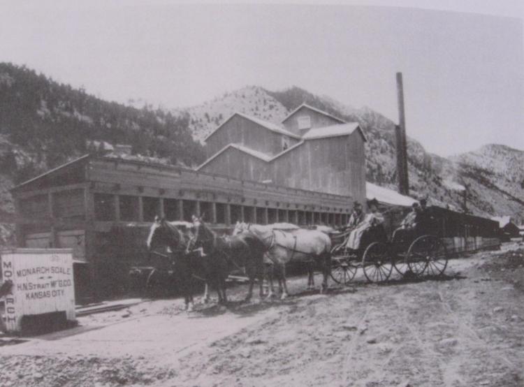 Historical Society of Idaho Springs, "A History of Clear Creek County" 2004 pg98, In that book can be found this view (dated 1890) of similar perspective to Robert Grandt's Title picture at the top of this thread but with the addition of the long orebins facing the Siding.
UpSideDownC
in New Zealand |
Re: Another "Where Is This" Picture
|
Nice find Chris! I'll have to find a copy of that book.
Doug
Doug Heitkamp
Centennial, CO |
Re: Another "Where Is This" Picture
|
Then I'd better post this then ..... should have been with the above but I forgot in my excitement over the Conoco find
 Note switchstand by trackwalkers, that is the Oil House siding, but before the "house" was built, the below grade tankcar dome is just visible on a line between the stack of ties in foreground and the first Boxcar on the Chamberlain Sampling works siding in the middle distance. This is also pre-Planing House of the Moscript & Hassell Lumber co. Note switchstand by trackwalkers, that is the Oil House siding, but before the "house" was built, the below grade tankcar dome is just visible on a line between the stack of ties in foreground and the first Boxcar on the Chamberlain Sampling works siding in the middle distance. This is also pre-Planing House of the Moscript & Hassell Lumber co.
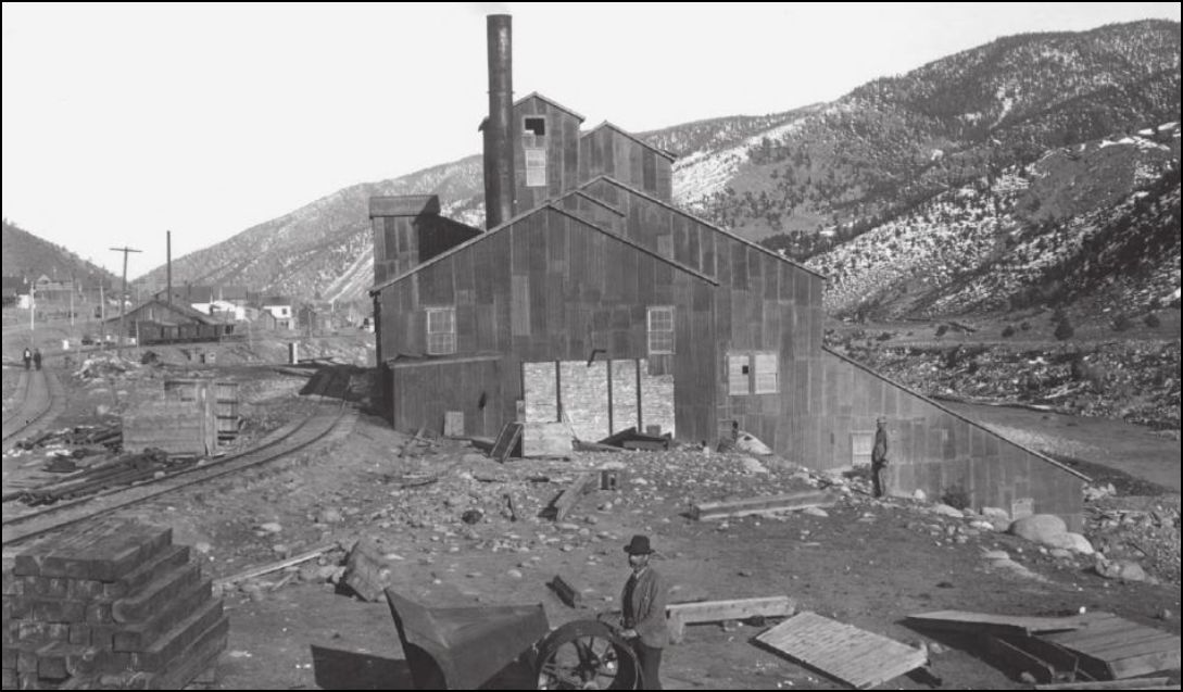 Lachlan McLean Photo from Idaho Springs Historical Society 1907 Sanborn (post-Fire Smith Mill) 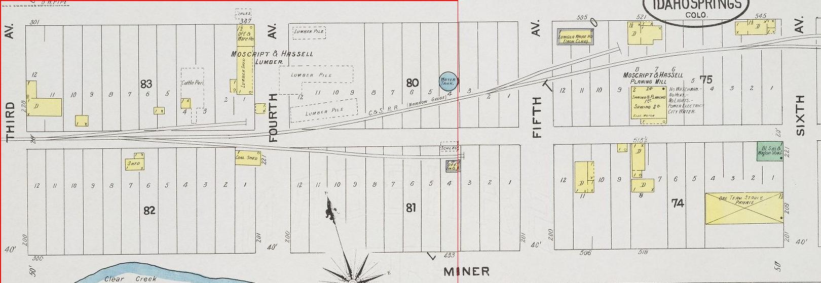
UpSideDownC
in New Zealand |
Re: Another "Where Is This" Picture
|
Ohhh, a cattle pen.
Keith Hayes
Leadville in Sn3 |
Re: Another "Where Is This" Picture
|
Administrator
|
In reply to this post by Doug Heitkamp
Book is free when you join the Clear Creek Historical Society.. I did earlier this year.
|
Re: Another "Where Is This" Picture
|
In reply to this post by Chris Walker
Another nice View of the Alpine and the Chamberlain.

UpSideDownC
in New Zealand |
«
Return to C&Sng Discussion Forum
|
1 view|%1 views
| Free forum by Nabble | Edit this page |

