Re: Dillon / Keystone Operations Revisited
Posted by Keith Hayes on
URL: http://c-sng-discussion-forum.254.s1.nabble.com/Freight-trains-at-Dillon-or-Keystone-tp1868p6609.html
Jim:
I was able to find a USGS topo from 1929 (Dillion Co, 1:62.5) that shows the contours roads and townsites before the lake. The location of the dam TOTALLY makes sense to me now. The map includes Dillon, Dickey, Frisco and Solitude/ Wheeler. Though the map is dated 1929 (based on 1927 data), it does not show the C&S or D&RGW ROW. There is also no indication that this was a map that was updated in, say, 1946 based on 1927-9 data. Even later maps often feature the abandoned ROW.
But we really don't need the ROW.
Now, if I was on the office computer, I could probably save the free PDF I downloaded to preview the map, along with a shaded area indicating the modern extant of the approximate shoreline. But that is for someone else to do.
The USGS maps are in the public domain. It might be interesting to find the TOC maps and post them. Just an idea.
Okay, take II:
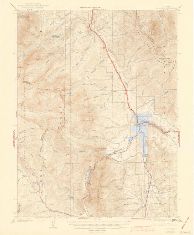
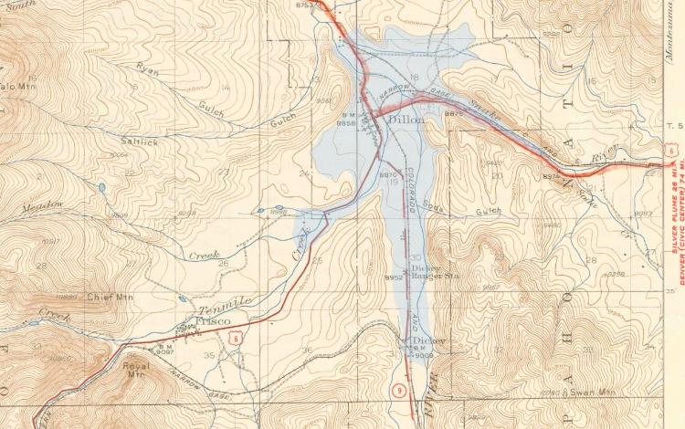
This is the Dillon quad from 1934. For reasons I don't understand, it has the ROW, which is extra handy. I grabbed the laptop and sketched in the water line just below the 9,000-foot contour for contemporary reference.
It all makes so much more sense now.
Enjoy.
Okay, take III, a bit larger this time:
URL: http://c-sng-discussion-forum.254.s1.nabble.com/Freight-trains-at-Dillon-or-Keystone-tp1868p6609.html
Jim:
I was able to find a USGS topo from 1929 (Dillion Co, 1:62.5) that shows the contours roads and townsites before the lake. The location of the dam TOTALLY makes sense to me now. The map includes Dillon, Dickey, Frisco and Solitude/ Wheeler. Though the map is dated 1929 (based on 1927 data), it does not show the C&S or D&RGW ROW. There is also no indication that this was a map that was updated in, say, 1946 based on 1927-9 data. Even later maps often feature the abandoned ROW.
But we really don't need the ROW.
Now, if I was on the office computer, I could probably save the free PDF I downloaded to preview the map, along with a shaded area indicating the modern extant of the approximate shoreline. But that is for someone else to do.
The USGS maps are in the public domain. It might be interesting to find the TOC maps and post them. Just an idea.
Okay, take II:
This is the Dillon quad from 1934. For reasons I don't understand, it has the ROW, which is extra handy. I grabbed the laptop and sketched in the water line just below the 9,000-foot contour for contemporary reference.
It all makes so much more sense now.
Enjoy.
Okay, take III, a bit larger this time:
Keith Hayes
Leadville in Sn3
Leadville in Sn3
| Free forum by Nabble | Edit this page |