Re: Dillon / Keystone Operations Revisited
Posted by Jim Courtney on
URL: http://c-sng-discussion-forum.254.s1.nabble.com/Freight-trains-at-Dillon-or-Keystone-tp1868p6592.html
Quite a few years ago, I purchased two sets of 1918 C&S Valuation Maps from the Colorado Railroad Museum, the sets that covered Platte Canon through Como, my primary C&S interest.
Jimmy Blouch's excellent thread on the D&RG Blue River branch (http://c-sng-discussion-forum.41377.n7.nabble.com/Ten-Mile-Stations-of-the-D-amp-RG-td6164.html) prompted me to recently purchase the two sets of maps covering Como to Leadville, via Boreas Pass, Breckenridge and the Ten Mile.
Tucked into the last several pages of the second Leadville set were maps for the Keystone Branch, including the Dillon station map:
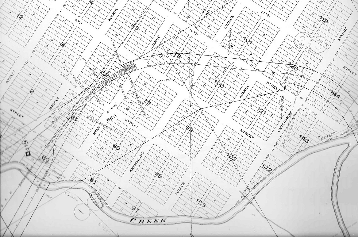
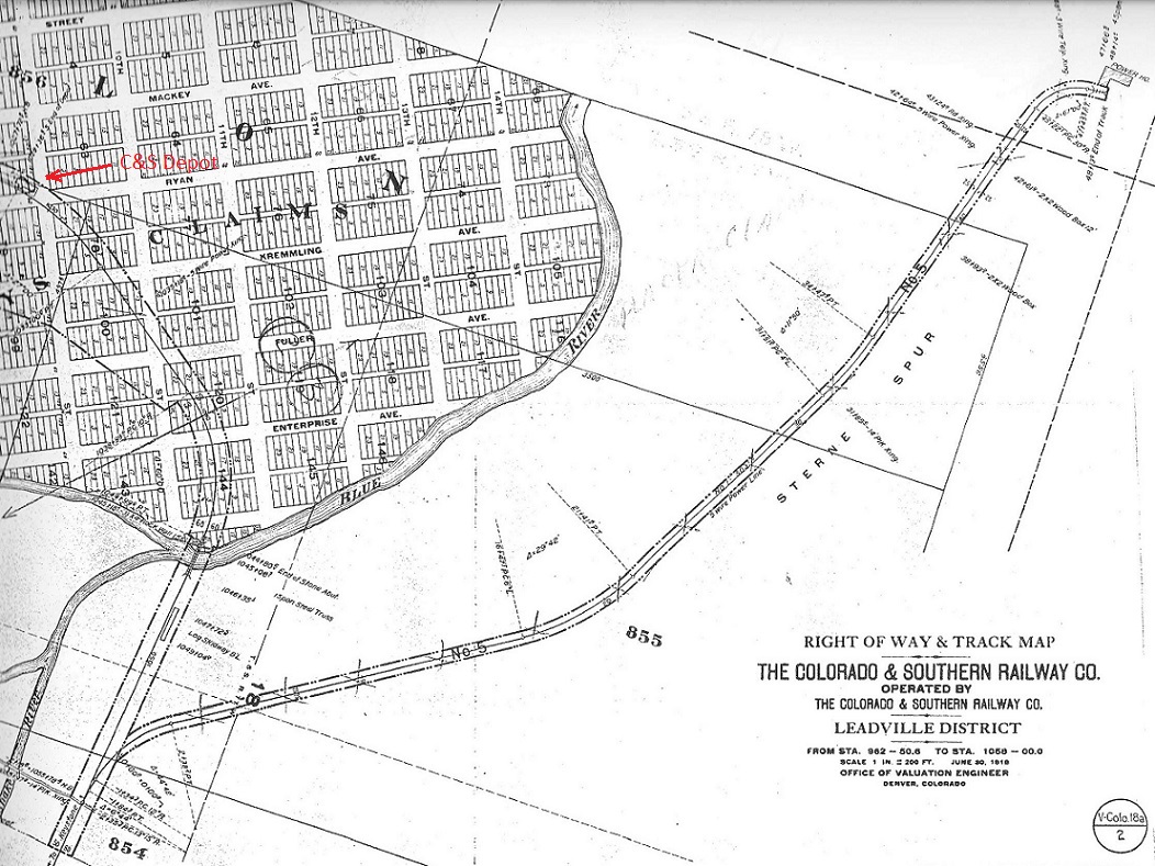
This busy map, showing the bridges over Ten Mile Creek, the C&S house track and the C&S depot area, was colored in at the top of this thread. Turns out, the house track at Dillon was the only double ended siding on the entire Keystone branch, at least by 1918.
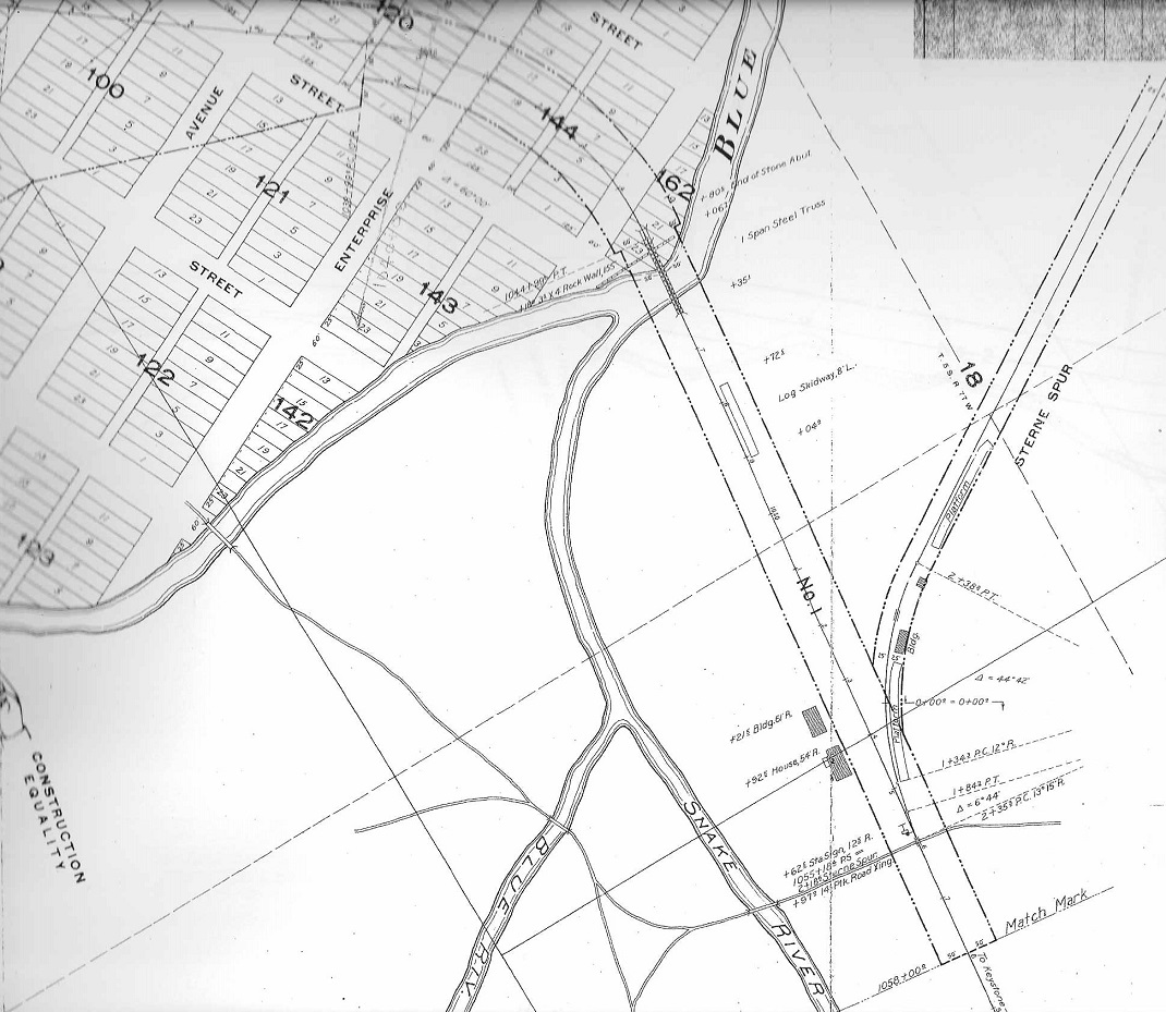
This right hand continuation of the Dillon station map shows how the C&S mainline made a near 180 degree curve to the east, from the crossing of Ten Mile Creek to the crossing of the Blue River. Just east of the Blue River bridge was a spur, Sterne's Spur, connecting to the mainline at the east (by compass) end. Note the spur had its own station sign, a couple of platforms for loading / unloading freight and a log skidway was located on the main between the bridge and the spur switch. Mac Poor lists the spur as 223 feet in length. But by 1918, Sterne's spur was much longer:
The spur was extended to the north, along the east bank of the Blue River three-quarters of a mile or so, to a power house serving some sort of industry, a placer mining operation perhaps? The history book Roadside Summit, The Human Landscape describes a shingle mill near this location and lime kilns just a bit further east. Note that the end of track for the spur, next to the power house, seems to have an elevated trestle or some such, for coal unloading.
Further to the east, headed toward Keystone, the mainline crossed the Snake River, on a pile trestle, just before mile post 122:
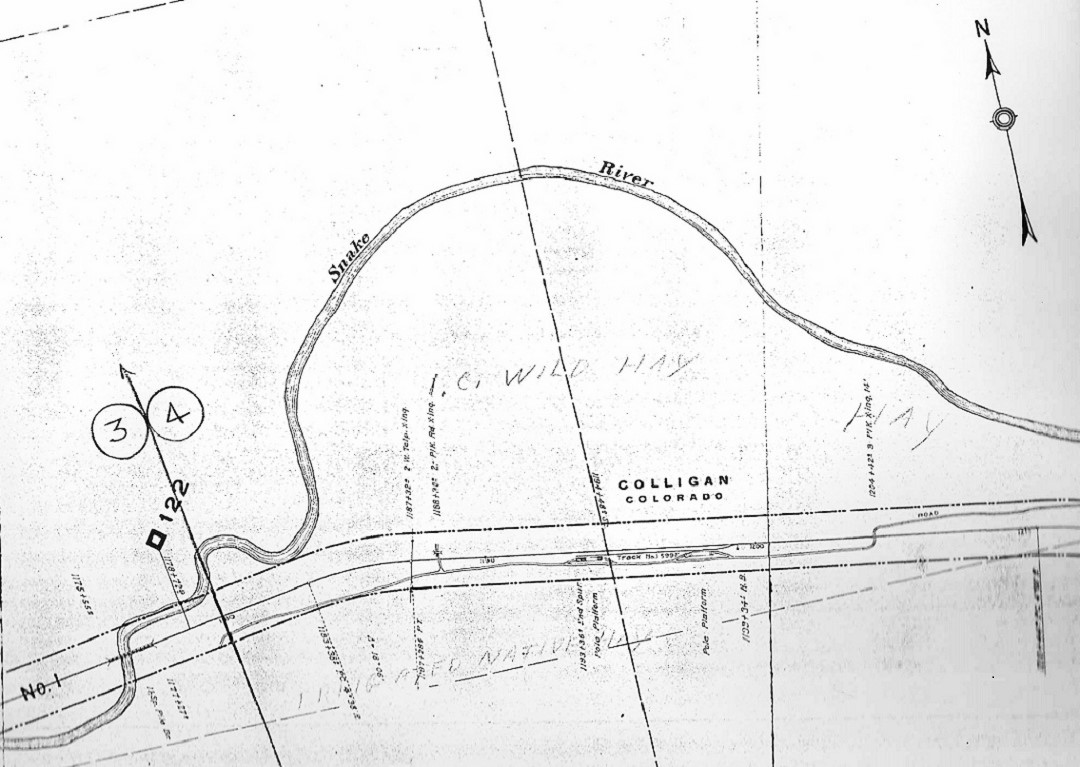
Just east of milepost 122 was a 599 foot spur that Mac Poor does't list, connected to the mainline at the east (compass) end. The 1918 valuation map lists the spur as Colligan (any relationship to "Curly", the engineer?). Two platforms with ramps at each end are clearly drawn on the south side of the spur, both connecting to the wagon road from Dillon to Montezuma and Peru Basin to the east. Who knows what was loaded / unloaded here -- local hay, perhaps, or maybe ore from the mines to the east.
The valuation map for Keystone itself was both surprising and disappointing:
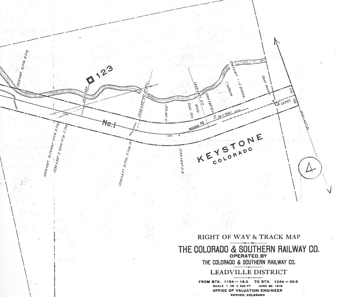
A single 700 foot spur, connecting to the mainline at its west end, served a coal bin, loading platform and the sawmill located here. The mainline simply stopped just east of the spur switch. The original mainline of the DSP&P to the depot and beyond, is shown as a dotted line, out of service. There is no representation of the wye that Mac Poor describes here at the end of the branch line.
But the map does jive with the only photo of Keystone that I've seen:
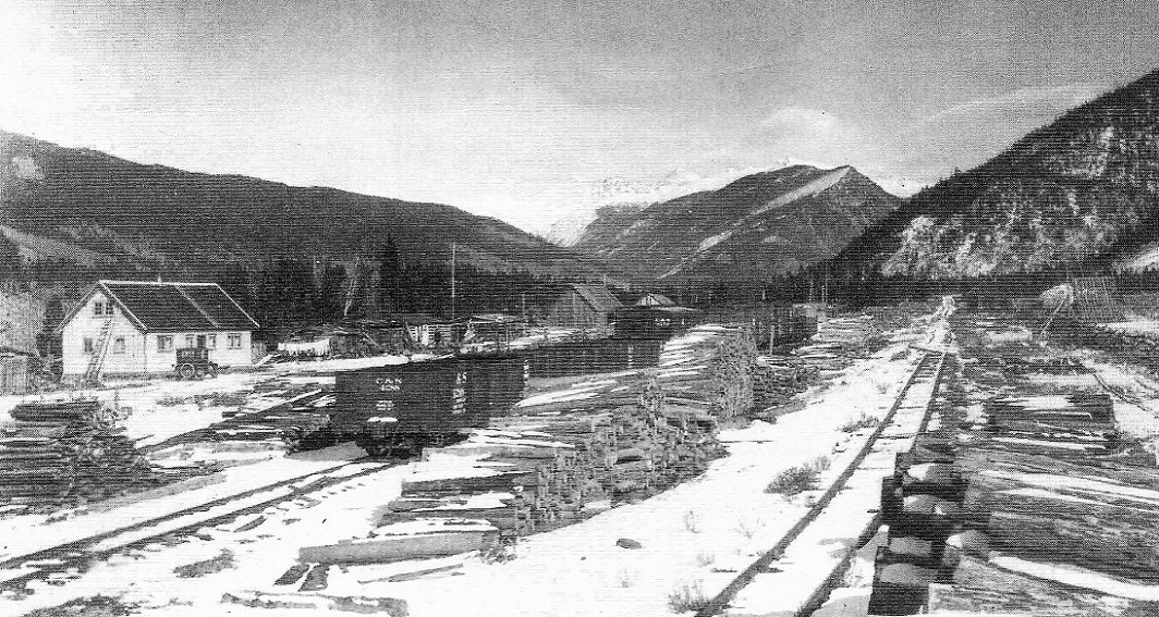
November, 1928. Colorado Historical Society, Whatley Collection, negative F15169. In the Klingers' C&S Highline Memories . . .
Looking east down the mainline, there is a single post used as a bumper of sorts at the end of track. The disconnected mainline to the depot remains visible in the distance. Clearly, any in bound freight cars delivered to Keystone were pushed upgrade ahead of the locomotive.
The track layout of the spurs at Colligan and Keystone, finally explain what's going on in this photo that we've discussed in the past:
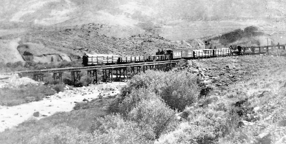
The locomotive and cars are backing across the Snake River trestle just below Colligan spur. The freight cars in front of the engine (loaded flats with mine props, two empty Peninsular coal cars, the boxcar) were likely pulled from the facing spur at Keystone, while the 2 or 3 boxcars behind the tender were likely pulled from the trailing spur at Colligan. I still don't understand D&RG boxcars north/east of Dillon. Perhaps they were inbound loads of supplies, taken in interchange with the D&RG at Leadville, consigned to Colligan spur for trans-shipment to the mines of Montezuma or Peru Basin. Now empty, perhaps they are being returned to Leadville.
This new (to me) information has changed my understanding of the Keystone branch: By 1918, there was no mechanism to turn locomotives anywhere on the Keystone branch north of Dickey. There was only one double ended siding on the entire branch, the house track by the Dillon depot. It seems to me that the entire branch line, from Dickey to Keystone, functioned as a very long seven-mile spur. Any round trip train movement, freight or passenger, required running in reverse half the time.
URL: http://c-sng-discussion-forum.254.s1.nabble.com/Freight-trains-at-Dillon-or-Keystone-tp1868p6592.html
Quite a few years ago, I purchased two sets of 1918 C&S Valuation Maps from the Colorado Railroad Museum, the sets that covered Platte Canon through Como, my primary C&S interest.
Jimmy Blouch's excellent thread on the D&RG Blue River branch (http://c-sng-discussion-forum.41377.n7.nabble.com/Ten-Mile-Stations-of-the-D-amp-RG-td6164.html) prompted me to recently purchase the two sets of maps covering Como to Leadville, via Boreas Pass, Breckenridge and the Ten Mile.
Tucked into the last several pages of the second Leadville set were maps for the Keystone Branch, including the Dillon station map:
This busy map, showing the bridges over Ten Mile Creek, the C&S house track and the C&S depot area, was colored in at the top of this thread. Turns out, the house track at Dillon was the only double ended siding on the entire Keystone branch, at least by 1918.
This right hand continuation of the Dillon station map shows how the C&S mainline made a near 180 degree curve to the east, from the crossing of Ten Mile Creek to the crossing of the Blue River. Just east of the Blue River bridge was a spur, Sterne's Spur, connecting to the mainline at the east (by compass) end. Note the spur had its own station sign, a couple of platforms for loading / unloading freight and a log skidway was located on the main between the bridge and the spur switch. Mac Poor lists the spur as 223 feet in length. But by 1918, Sterne's spur was much longer:
The spur was extended to the north, along the east bank of the Blue River three-quarters of a mile or so, to a power house serving some sort of industry, a placer mining operation perhaps? The history book Roadside Summit, The Human Landscape describes a shingle mill near this location and lime kilns just a bit further east. Note that the end of track for the spur, next to the power house, seems to have an elevated trestle or some such, for coal unloading.
Further to the east, headed toward Keystone, the mainline crossed the Snake River, on a pile trestle, just before mile post 122:
Just east of milepost 122 was a 599 foot spur that Mac Poor does't list, connected to the mainline at the east (compass) end. The 1918 valuation map lists the spur as Colligan (any relationship to "Curly", the engineer?). Two platforms with ramps at each end are clearly drawn on the south side of the spur, both connecting to the wagon road from Dillon to Montezuma and Peru Basin to the east. Who knows what was loaded / unloaded here -- local hay, perhaps, or maybe ore from the mines to the east.
The valuation map for Keystone itself was both surprising and disappointing:
A single 700 foot spur, connecting to the mainline at its west end, served a coal bin, loading platform and the sawmill located here. The mainline simply stopped just east of the spur switch. The original mainline of the DSP&P to the depot and beyond, is shown as a dotted line, out of service. There is no representation of the wye that Mac Poor describes here at the end of the branch line.
But the map does jive with the only photo of Keystone that I've seen:
November, 1928. Colorado Historical Society, Whatley Collection, negative F15169. In the Klingers' C&S Highline Memories . . .
Looking east down the mainline, there is a single post used as a bumper of sorts at the end of track. The disconnected mainline to the depot remains visible in the distance. Clearly, any in bound freight cars delivered to Keystone were pushed upgrade ahead of the locomotive.
The track layout of the spurs at Colligan and Keystone, finally explain what's going on in this photo that we've discussed in the past:
The locomotive and cars are backing across the Snake River trestle just below Colligan spur. The freight cars in front of the engine (loaded flats with mine props, two empty Peninsular coal cars, the boxcar) were likely pulled from the facing spur at Keystone, while the 2 or 3 boxcars behind the tender were likely pulled from the trailing spur at Colligan. I still don't understand D&RG boxcars north/east of Dillon. Perhaps they were inbound loads of supplies, taken in interchange with the D&RG at Leadville, consigned to Colligan spur for trans-shipment to the mines of Montezuma or Peru Basin. Now empty, perhaps they are being returned to Leadville.
This new (to me) information has changed my understanding of the Keystone branch: By 1918, there was no mechanism to turn locomotives anywhere on the Keystone branch north of Dickey. There was only one double ended siding on the entire branch, the house track by the Dillon depot. It seems to me that the entire branch line, from Dickey to Keystone, functioned as a very long seven-mile spur. Any round trip train movement, freight or passenger, required running in reverse half the time.
Jim Courtney
Poulsbo, WA
Poulsbo, WA
| Free forum by Nabble | Edit this page |