Re: Along The Gilpin Tramway - A Closer Look-Warming House.
Posted by Keith Pashina on Jan 26, 2025; 5:35am
URL: http://c-sng-discussion-forum.254.s1.nabble.com/Along-The-Gilpin-Tramway-A-Closer-Look-tp20380p20470.html
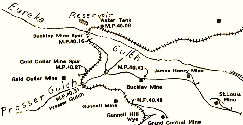
This map shows the Buckley Mine trackage, and was prepared by Dan Abbott. Originally published in the Gilpin Railroad Historical Society Newsletter No. 4.
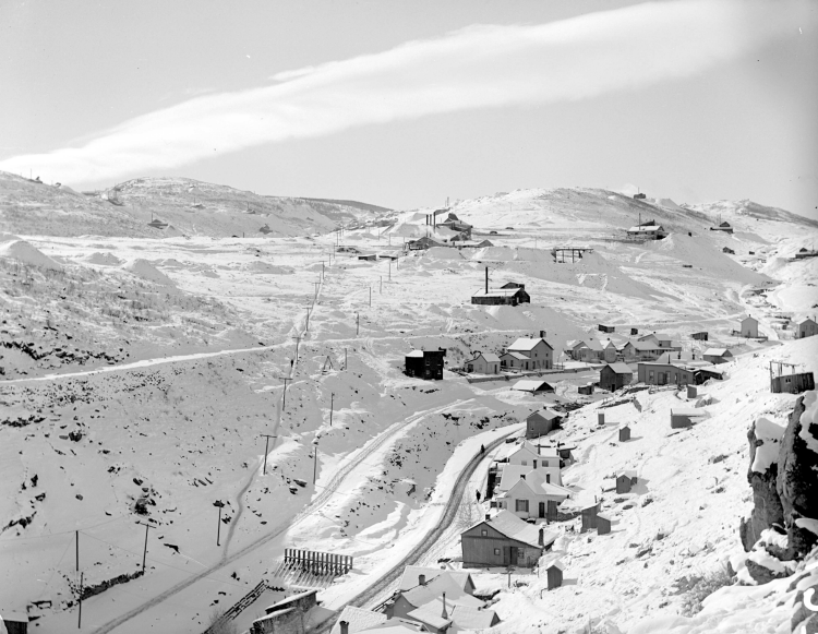
Another companion photo, also from Denver Public Library Western History Collection (DPL), shows the branch grade (it intersects the center of the left margin). In the center is the Buckley Mine. Immediately below is Eureka Street, a residential area.
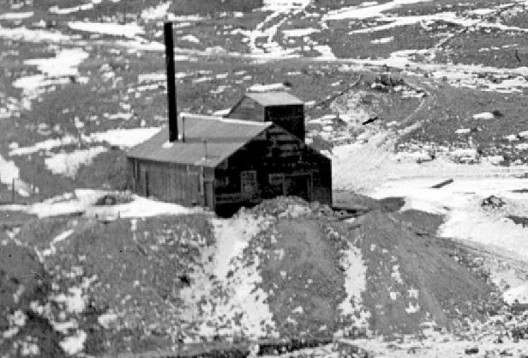
An enlargement of a prior DPL photo shows the Buckley Mine. I have been unable to tell from photos, and from walking the site, where the tram trackage was located. There is waste rock covering part of the branch grade below, indicating the mine was worked to some extent after the tram tracks were torn up or out of operation.
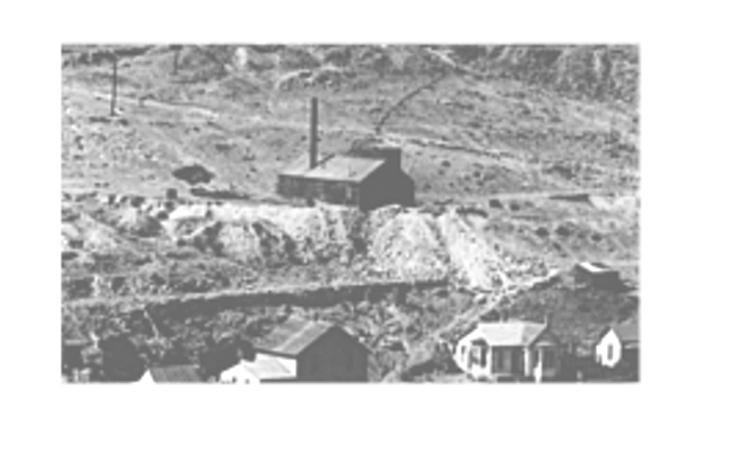
The large stone retaining wall seen in the previous photo is still there. The grade on the wall is unusually wide, and there could have been two tracks here, but there is no photographic evidence of this having been done.
Here’s another view of the branch retaining wall.
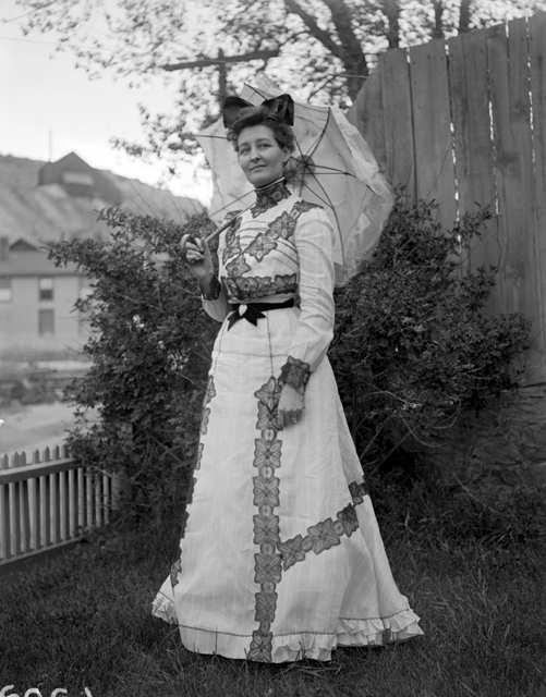
Sometimes you can find information about the tram and its mines where you don’t expect it. This is a DPL image taken by HH Lake, and shows his wife in her new dress in their backyard. In the upper left background is one of the few images of the James Henry Mine. This photo also demonstrates how close the mine operations were to Central City, as was a lot of the Gilpin Tram trackage.
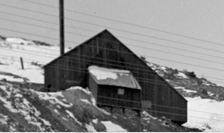
Enlarging the same DPL photo as previous, we get a better view of the James Henry mine’s east side. This photo is dated 1899.
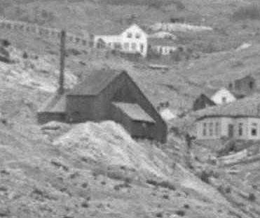
Greatly enlarged, this is another DPL image from about 1900, and shows more of the southeasterly side. The mine is comprised of the main shaft building, a boiler house on the west side, and perhaps a blacksmith shop on the east side. We’re looking northwest in this photo.
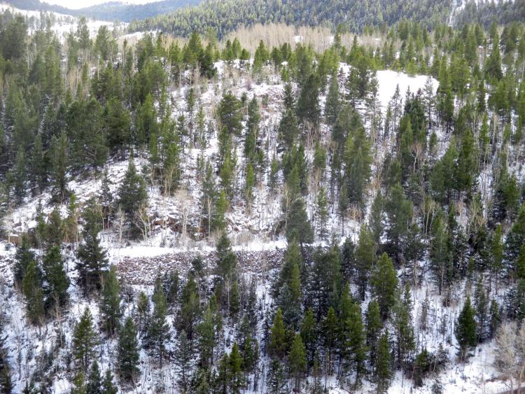
This is the James Henry mine site today. The branch grade is easily seen on the right side of the waste rock dump.
The James Henry mine structure is gone, except for the boiler. This artifact is a good view of how to model a mine boiler. I built an HO scale model from pacing off the distance from the smokestack and shaft, and then guesstimating dimensions off of the photos. No drawings exist, so I’ll claim that this is a precise model!
From the James Henry mine dump, we’re looking east/southeast, towards the St. Louis-Gunnell mine. Also, note how close the mine and branch are to Central City proper. I find it appealing as to how compact the whole Gilpin County mining districts and towns are.
Here is another image enlargement, the parent photo is from DPL. The St. Louis-Gunnell mine is at left center, and just beyond it, the James Henry Mine. This photo illustrates how close the mines were to each other on this short branch.
An enlargement of the parent photo shows the west and north sides of the St. Louis-Gunnell Mine. According to the Sanborn Fire Insurance map for this mine, Gilpin Tram trackage extended on both the north and south sides of this building. I see no evidence of trackage in this photo, so perhaps it was taken after 1910. This image is from the Denver Public Library, Western History Collection (DPL) and is image L-27.
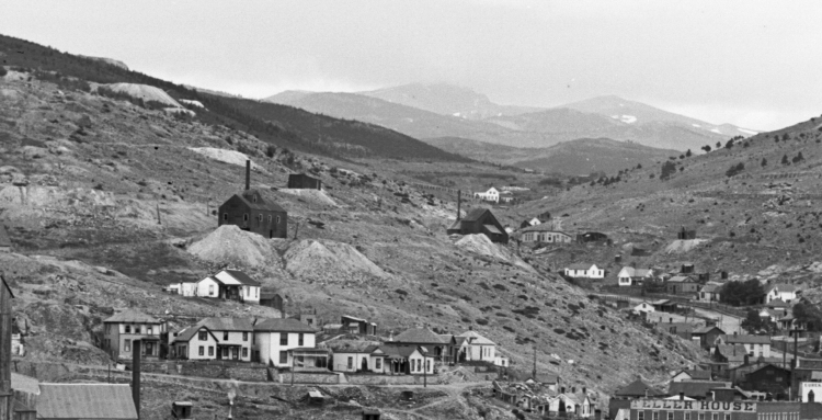
This DPL photo is image L-25, and another enlargement of the parent photo. The St. Louis-Gunnell mine stands all by itself in the center of the photo. The Gilpin Tram grades are easily seen in the snow. The large building just to the left of the mine is the St. Aloysius Academy. This was a Catholic parochial school in Central City, and this photo again illustrates how closely intertwined was the town and mining areas.
This is another enlargement of a DPL image, showing the St. Louis mine and the St. Aloysius Academy beyond. The mine looks rather forlorn here, and I would guess abandoned at this time. The Gilpin Tram grade can be seem on the right side of the building. Notice the city water reservoir building to the left of the mine – one of 3 that Central City built for their water supply.

This view was taken 9 years ago, from the St. Louis Gunnell mine site. Looking southeast, we see the Central City reservoir roof and triangular stone end walls at left center, and to its immediate right is the remains of the St. Aloysius Academy. The building was demolished decades ago, and the bottom portion saved. The white cross the marks the Kruse Memorial. The Freedom Mine dump is on the far hillside at center. Note the “progress” – there a 40 story hotel building standing at the far end of the valley, down in Black Hawk.
Today, nothing remains of the St. Louis mine, except a few stone retaining wall remnants. The Gilpin County Observer reported on March 7, 1902, “The heavy stone retaining wall, placed several years ago to secure the siding of the tramway back from its main track to the St. Louis mine on the easterly portion of Gunnell Hill, has been torn down and the track removed. So, this mine ended service early.
Well, that wraps up our look at the Buckley Mine Branch. Next, we’ll go back to the main line and visit Prosser Gulch, then start exploring the numerous mines and trackage up on Gunnell Hill.
URL: http://c-sng-discussion-forum.254.s1.nabble.com/Along-The-Gilpin-Tramway-A-Closer-Look-tp20380p20470.html
This map shows the Buckley Mine trackage, and was prepared by Dan Abbott. Originally published in the Gilpin Railroad Historical Society Newsletter No. 4.
Another companion photo, also from Denver Public Library Western History Collection (DPL), shows the branch grade (it intersects the center of the left margin). In the center is the Buckley Mine. Immediately below is Eureka Street, a residential area.
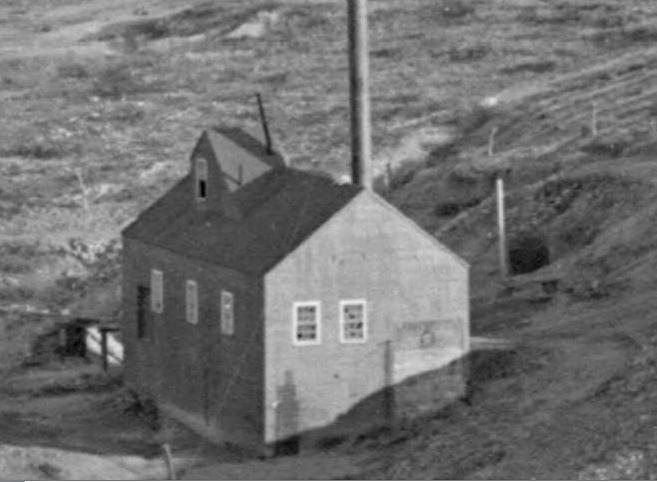
An enlargement of a prior DPL photo shows the Buckley Mine. I have been unable to tell from photos, and from walking the site, where the tram trackage was located. There is waste rock covering part of the branch grade below, indicating the mine was worked to some extent after the tram tracks were torn up or out of operation.
The large stone retaining wall seen in the previous photo is still there. The grade on the wall is unusually wide, and there could have been two tracks here, but there is no photographic evidence of this having been done.
Here’s another view of the branch retaining wall.
Sometimes you can find information about the tram and its mines where you don’t expect it. This is a DPL image taken by HH Lake, and shows his wife in her new dress in their backyard. In the upper left background is one of the few images of the James Henry Mine. This photo also demonstrates how close the mine operations were to Central City, as was a lot of the Gilpin Tram trackage.
Enlarging the same DPL photo as previous, we get a better view of the James Henry mine’s east side. This photo is dated 1899.
Greatly enlarged, this is another DPL image from about 1900, and shows more of the southeasterly side. The mine is comprised of the main shaft building, a boiler house on the west side, and perhaps a blacksmith shop on the east side. We’re looking northwest in this photo.
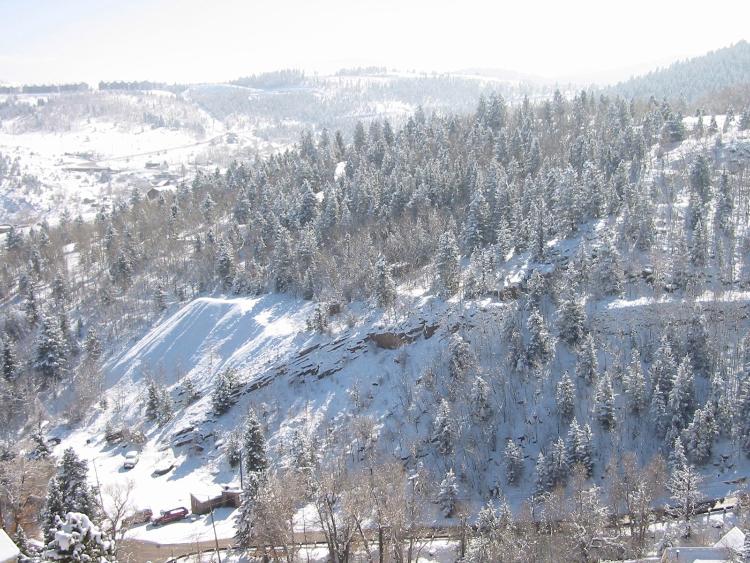
This is the James Henry mine site today. The branch grade is easily seen on the right side of the waste rock dump.
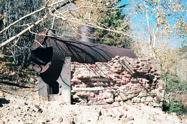
The James Henry mine structure is gone, except for the boiler. This artifact is a good view of how to model a mine boiler. I built an HO scale model from pacing off the distance from the smokestack and shaft, and then guesstimating dimensions off of the photos. No drawings exist, so I’ll claim that this is a precise model!
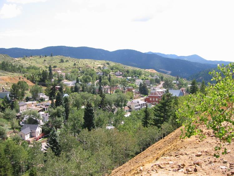
From the James Henry mine dump, we’re looking east/southeast, towards the St. Louis-Gunnell mine. Also, note how close the mine and branch are to Central City proper. I find it appealing as to how compact the whole Gilpin County mining districts and towns are.
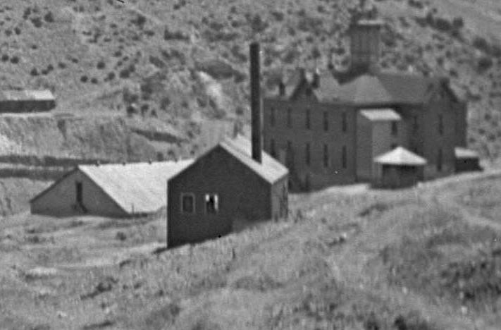
Here is another image enlargement, the parent photo is from DPL. The St. Louis-Gunnell mine is at left center, and just beyond it, the James Henry Mine. This photo illustrates how close the mines were to each other on this short branch.
An enlargement of the parent photo shows the west and north sides of the St. Louis-Gunnell Mine. According to the Sanborn Fire Insurance map for this mine, Gilpin Tram trackage extended on both the north and south sides of this building. I see no evidence of trackage in this photo, so perhaps it was taken after 1910. This image is from the Denver Public Library, Western History Collection (DPL) and is image L-27.
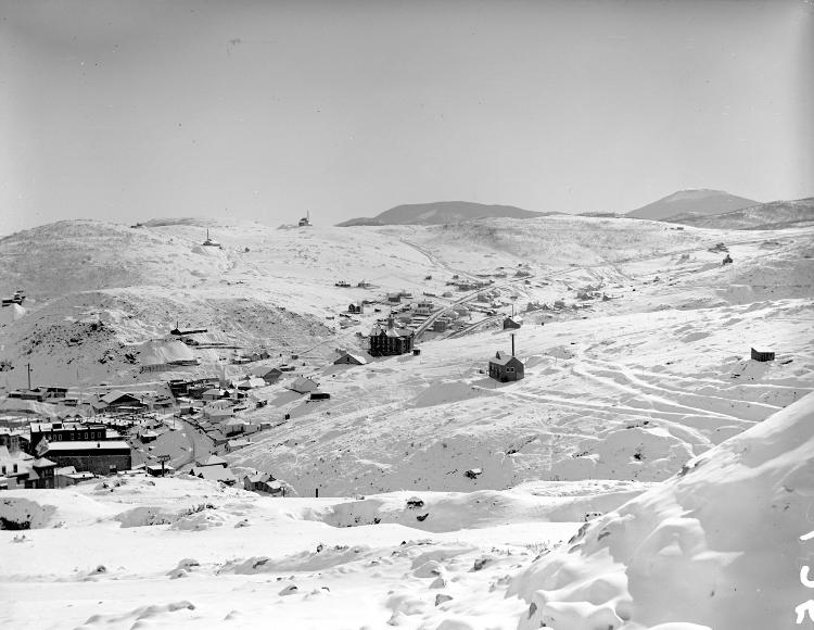
This DPL photo is image L-25, and another enlargement of the parent photo. The St. Louis-Gunnell mine stands all by itself in the center of the photo. The Gilpin Tram grades are easily seen in the snow. The large building just to the left of the mine is the St. Aloysius Academy. This was a Catholic parochial school in Central City, and this photo again illustrates how closely intertwined was the town and mining areas.
This is another enlargement of a DPL image, showing the St. Louis mine and the St. Aloysius Academy beyond. The mine looks rather forlorn here, and I would guess abandoned at this time. The Gilpin Tram grade can be seem on the right side of the building. Notice the city water reservoir building to the left of the mine – one of 3 that Central City built for their water supply.
This view was taken 9 years ago, from the St. Louis Gunnell mine site. Looking southeast, we see the Central City reservoir roof and triangular stone end walls at left center, and to its immediate right is the remains of the St. Aloysius Academy. The building was demolished decades ago, and the bottom portion saved. The white cross the marks the Kruse Memorial. The Freedom Mine dump is on the far hillside at center. Note the “progress” – there a 40 story hotel building standing at the far end of the valley, down in Black Hawk.
Today, nothing remains of the St. Louis mine, except a few stone retaining wall remnants. The Gilpin County Observer reported on March 7, 1902, “The heavy stone retaining wall, placed several years ago to secure the siding of the tramway back from its main track to the St. Louis mine on the easterly portion of Gunnell Hill, has been torn down and the track removed. So, this mine ended service early.
Well, that wraps up our look at the Buckley Mine Branch. Next, we’ll go back to the main line and visit Prosser Gulch, then start exploring the numerous mines and trackage up on Gunnell Hill.
Keith Pashina
Narrow-minded in Arizona
Narrow-minded in Arizona
| Free forum by Nabble | Edit this page |