Re: Along The Gilpin Tramway - A Closer Look
Posted by Keith Pashina on Jan 20, 2025; 5:38pm
URL: http://c-sng-discussion-forum.254.s1.nabble.com/Along-The-Gilpin-Tramway-A-Closer-Look-tp20380p20444.html
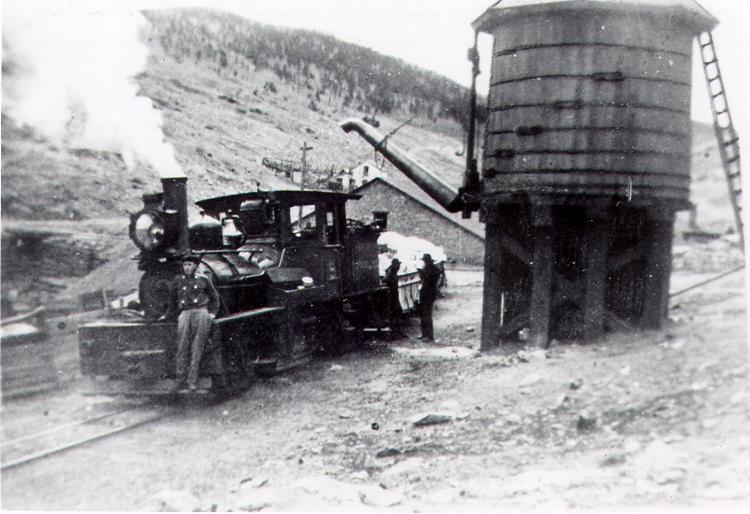
This view, from the Denver Public Library, Western History Collection, shows a loaded ore train pausing at the second water tank at Eureka Gulch. In the background is the City water reservoir and the Eureka Gulch bridge.
Eureka Gulch, at Milepost 40.08
Eureka Gulch was crossed by the Gilpin Tram grade on a broad curve.
These locomotives worked hard to climb out of the Clear Creek canyon, winding around the rugged rocky hillsides of Chase Gulch. The grade never really relented until the prime Quartz Hill mining district was reached, 4 miles uphill from Black Hawk. The little shay locomotives had fairly small water tanks in their tenders, and worked up quite a thirst climbing up the long grade up Chase Gulch.
The mining country around Central City has always had problems with a good water supply. Water pumped out of the local mountainsides tended to be heavily laden with minerals, which caused scale, foaming and other problems with boilers. In fact, water quality was so poor, several mines had to have their boiler water hauled in to them on the Gilpin Tram’s specially built water tank car.
When the Gilpin Tram crossed Eureka Street in Central City, they saw a golden opportunity for a clean, reliable water supply. The two-footer crossed Eureka Street about a half mile uphill from downtown Central City, at milepost 40.08. The city had built a water storage reservoir, for storing the water piped in from ranches several miles away. The Tram’s Eureka Street crossing was also 4 miles uphill from the Black Hawk engine house, and the shay tanks were probably pretty well drained after laboring their way upgrade with loaded coal cars and a long strings of empty ore cars.
Central City had built a network of 3 reservoirs strategically set around town. The tram took water directly from the reservoir, paying for the water supply.
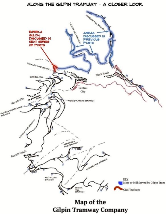
This map shows the location of Eureka Gulch, in relation to the portions of the Gilpin Tram we have covered in previous posts.
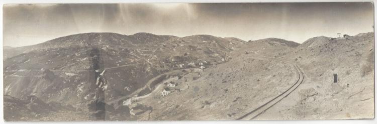
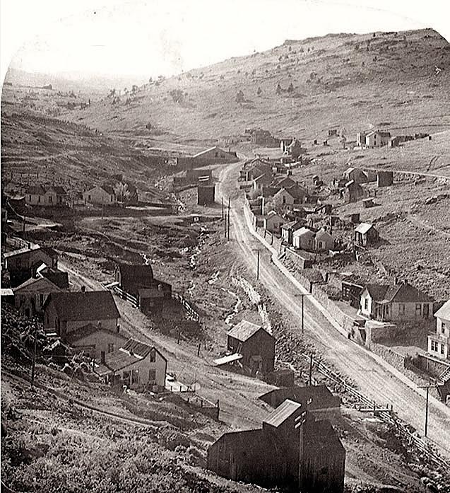
This nice view is looking towards Eureka Gulch. The photographer was standing on Winnebago Hill, looking west. Gunnell Hill dominates the center of this seen. I borrowed this image from another post on this C&Sng blog, and bot I cannot find the original post. My apologies to the original poster, for not being able to give you proper credit.
The Gilpin Tram actually built two different water tanks at Eureka Street. The first was an enclosed tiny affair, constructed in 1887. It was later replaced by a larger tank that was built in about 1900, due to the increased traffic and larger shay locomotives being used at the time. The original shays #1 and #2 were being sold at about this time to the Silver City, Pinos Altos and Mogollon line in New Mexico. The Gilpin Tram purchased the larger shays #4 and #5 in 1900 and 1902, respectively. These locomotives were not only more powerful than the first shays, but consumed more water, too.
The first tank was located on the south side of the tracks, and had an enclosed base. In the photograph, you can see how tiny the whole structure really was. This is the only close up photograph I have ever seen of this tank.
A Gilpin Tram shay with what appear to be 6 ore cars loaded with coal is approaching Eureka Gulch. At the gulch, the first water tank can be seen. Photo courtesy of the Mark Baldwin collection.
Another view of Eureka Street, looking west. The gulch is to the left of the street. The Gilpin Tram grade can be seen at right center, where is will cross the gulch on a broad curve. Photo courtesy of the Mark Baldwin collection.
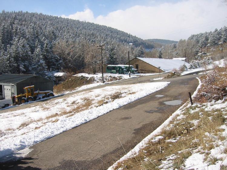
This is Eureka Gulch in modern times – photo was taken about 15 years ago. The paved road in the foreground is the former tram grade. The pipe sticking up on the right side marks the standpipe location of the second water tank. The water reservoir and bridge site can be seen in the background.
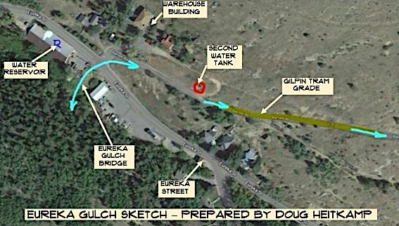
This overhead view of Eureka Gulch was prepared by Doug Heitkamp several years ago. All the key locations are marked.
Shay #1 has halted at the first water tank. Although adequate for small shays #1 and #2, as traffic increased and 3rd shay was purchased, the tank was soon undersized and replaced. Image from the Denver Public Library, Western History Collection.
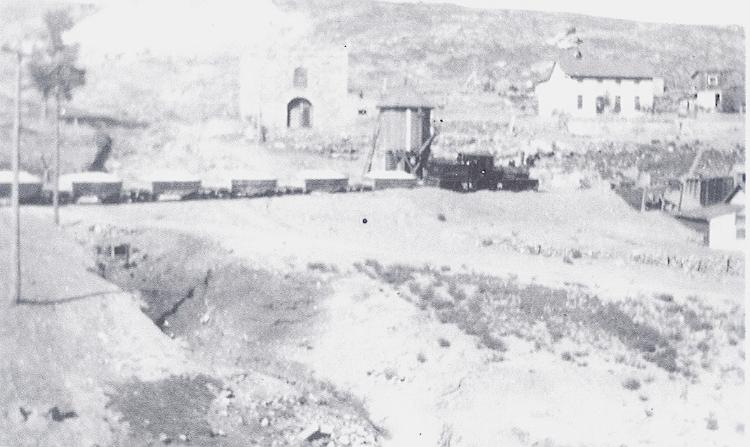
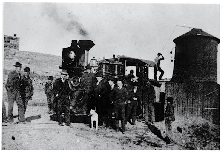
This image was provided by Dan Abbott, and shows Shay #3 headed downgrade with a train of loaded ore cars, and has paused at the 2nd water tank, perhaps for the photographer. Note the building just to the left of the water tank – it is still there today.
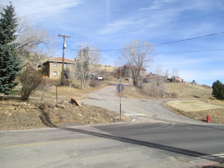
Another recent view of Eureka Gulch – the grade is the curving as it crosses Eureka Gulch. The same stone building is at left center.
URL: http://c-sng-discussion-forum.254.s1.nabble.com/Along-The-Gilpin-Tramway-A-Closer-Look-tp20380p20444.html
This view, from the Denver Public Library, Western History Collection, shows a loaded ore train pausing at the second water tank at Eureka Gulch. In the background is the City water reservoir and the Eureka Gulch bridge.
Eureka Gulch, at Milepost 40.08
Eureka Gulch was crossed by the Gilpin Tram grade on a broad curve.
These locomotives worked hard to climb out of the Clear Creek canyon, winding around the rugged rocky hillsides of Chase Gulch. The grade never really relented until the prime Quartz Hill mining district was reached, 4 miles uphill from Black Hawk. The little shay locomotives had fairly small water tanks in their tenders, and worked up quite a thirst climbing up the long grade up Chase Gulch.
The mining country around Central City has always had problems with a good water supply. Water pumped out of the local mountainsides tended to be heavily laden with minerals, which caused scale, foaming and other problems with boilers. In fact, water quality was so poor, several mines had to have their boiler water hauled in to them on the Gilpin Tram’s specially built water tank car.
When the Gilpin Tram crossed Eureka Street in Central City, they saw a golden opportunity for a clean, reliable water supply. The two-footer crossed Eureka Street about a half mile uphill from downtown Central City, at milepost 40.08. The city had built a water storage reservoir, for storing the water piped in from ranches several miles away. The Tram’s Eureka Street crossing was also 4 miles uphill from the Black Hawk engine house, and the shay tanks were probably pretty well drained after laboring their way upgrade with loaded coal cars and a long strings of empty ore cars.
Central City had built a network of 3 reservoirs strategically set around town. The tram took water directly from the reservoir, paying for the water supply.
This map shows the location of Eureka Gulch, in relation to the portions of the Gilpin Tram we have covered in previous posts.
This nice view is looking towards Eureka Gulch. The photographer was standing on Winnebago Hill, looking west. Gunnell Hill dominates the center of this seen. I borrowed this image from another post on this C&Sng blog, and bot I cannot find the original post. My apologies to the original poster, for not being able to give you proper credit.
The Gilpin Tram actually built two different water tanks at Eureka Street. The first was an enclosed tiny affair, constructed in 1887. It was later replaced by a larger tank that was built in about 1900, due to the increased traffic and larger shay locomotives being used at the time. The original shays #1 and #2 were being sold at about this time to the Silver City, Pinos Altos and Mogollon line in New Mexico. The Gilpin Tram purchased the larger shays #4 and #5 in 1900 and 1902, respectively. These locomotives were not only more powerful than the first shays, but consumed more water, too.
The first tank was located on the south side of the tracks, and had an enclosed base. In the photograph, you can see how tiny the whole structure really was. This is the only close up photograph I have ever seen of this tank.
A Gilpin Tram shay with what appear to be 6 ore cars loaded with coal is approaching Eureka Gulch. At the gulch, the first water tank can be seen. Photo courtesy of the Mark Baldwin collection.
Another view of Eureka Street, looking west. The gulch is to the left of the street. The Gilpin Tram grade can be seen at right center, where is will cross the gulch on a broad curve. Photo courtesy of the Mark Baldwin collection.
This is Eureka Gulch in modern times – photo was taken about 15 years ago. The paved road in the foreground is the former tram grade. The pipe sticking up on the right side marks the standpipe location of the second water tank. The water reservoir and bridge site can be seen in the background.
This overhead view of Eureka Gulch was prepared by Doug Heitkamp several years ago. All the key locations are marked.
Shay #1 has halted at the first water tank. Although adequate for small shays #1 and #2, as traffic increased and 3rd shay was purchased, the tank was soon undersized and replaced. Image from the Denver Public Library, Western History Collection.
This image was provided by Dan Abbott, and shows Shay #3 headed downgrade with a train of loaded ore cars, and has paused at the 2nd water tank, perhaps for the photographer. Note the building just to the left of the water tank – it is still there today.
Another recent view of Eureka Gulch – the grade is the curving as it crosses Eureka Gulch. The same stone building is at left center.
Keith Pashina
Narrow-minded in Arizona
Narrow-minded in Arizona
| Free forum by Nabble | Edit this page |