Re: Along The Gilpin Tramway - A Closer Look
Posted by Keith Pashina on Jan 10, 2025; 9:29pm
URL: http://c-sng-discussion-forum.254.s1.nabble.com/Along-The-Gilpin-Tramway-A-Closer-Look-tp20380p20428.html
Chris - good information on the Boodle Mine. Thanks for posting it. This operation was a lot more extensive than I had realized. I am also glad the building has been saved - it's easily seen from a public road.
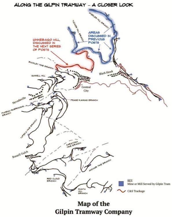
This map shows the location of Winnebago Hill, and the sections of the Gilpin Tramway covered in previous posts.
WINNEBAGO HILL
Back at Tucker Mill Junction, which is at the head of Chase Gulch, the Gilpin Tram main line crossed the Chase Gulch stream bed over a dry laid stone retaining wall and short bridge, and began its climb up Winnebago Hill. Winnebago Hill is a long narrow hill running generally east-west. The Gilpin Tram needed to climb around the north, east and south sides to reach Eureka Gulch. To do so, the grade climbs about 300’.
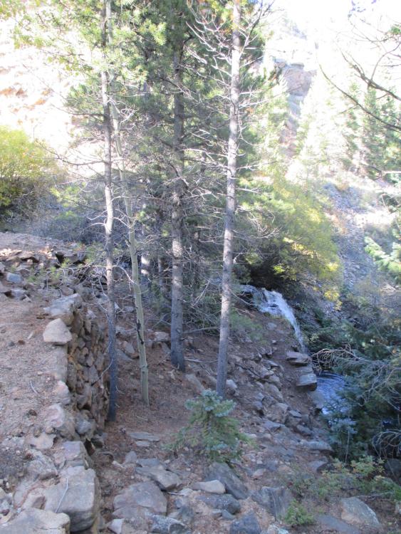
The grade was supported on dry laid stone walls as it crossed Chase Gulch. The small waterfall at this location can be seen. View is looking north.
The main line curved around nearly 180 degrees, and began its assault on the north slope of Winnebago Hill. Inside this curve was the Belden Tunnel. This mine had high hopes, and at one point began construction of a stamp mill nearby – the stone wall ruins can be seen today. To the best of my knowledge, this mining operation was not a shipper on the Gilpin Tram.
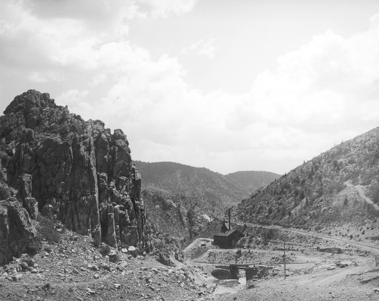
The tramway grade makes mule-shoe-like curve here, and the steepness of the grade as it climbs Winnebago Hill is easily seen. Castle Rock is at the left, Chase Gulch and the bridge in the center, and the Belden Tunnel is just above it. The branch to Tucker Mill had not be constructed at the time this photograph was made. This view taken by H.H. Lake is from the Denver Public Library, Western History Collection, Image Z-6877.
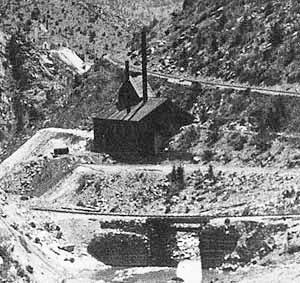
An enlargement of the previous photo shows the Belden Tunnel. The mine is tucked inside the mule-shoe curve. This would make a great scene on a model railroad! Today, the mine and railroad bridge have vanished from this site.
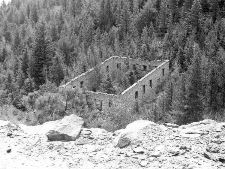
The Belden Tunnel company had ambitious plans, and had begun a stamp mill nearby in Chase Gulch. This structure was never completed, however. This image is from the grade near Castle Rock, and looking south across Chase Gulch. This is from the Denver Public Library, Western History Collection, Image X -2077. The ruins are still there today.
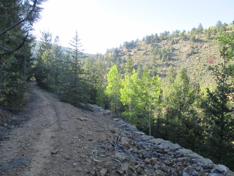
Climbing further, a very substantial and wide roadbed was constructed above a dry laid stone wall. View looking west.
URL: http://c-sng-discussion-forum.254.s1.nabble.com/Along-The-Gilpin-Tramway-A-Closer-Look-tp20380p20428.html
Chris - good information on the Boodle Mine. Thanks for posting it. This operation was a lot more extensive than I had realized. I am also glad the building has been saved - it's easily seen from a public road.
This map shows the location of Winnebago Hill, and the sections of the Gilpin Tramway covered in previous posts.
WINNEBAGO HILL
Back at Tucker Mill Junction, which is at the head of Chase Gulch, the Gilpin Tram main line crossed the Chase Gulch stream bed over a dry laid stone retaining wall and short bridge, and began its climb up Winnebago Hill. Winnebago Hill is a long narrow hill running generally east-west. The Gilpin Tram needed to climb around the north, east and south sides to reach Eureka Gulch. To do so, the grade climbs about 300’.
The grade was supported on dry laid stone walls as it crossed Chase Gulch. The small waterfall at this location can be seen. View is looking north.
The main line curved around nearly 180 degrees, and began its assault on the north slope of Winnebago Hill. Inside this curve was the Belden Tunnel. This mine had high hopes, and at one point began construction of a stamp mill nearby – the stone wall ruins can be seen today. To the best of my knowledge, this mining operation was not a shipper on the Gilpin Tram.
The tramway grade makes mule-shoe-like curve here, and the steepness of the grade as it climbs Winnebago Hill is easily seen. Castle Rock is at the left, Chase Gulch and the bridge in the center, and the Belden Tunnel is just above it. The branch to Tucker Mill had not be constructed at the time this photograph was made. This view taken by H.H. Lake is from the Denver Public Library, Western History Collection, Image Z-6877.
An enlargement of the previous photo shows the Belden Tunnel. The mine is tucked inside the mule-shoe curve. This would make a great scene on a model railroad! Today, the mine and railroad bridge have vanished from this site.
The Belden Tunnel company had ambitious plans, and had begun a stamp mill nearby in Chase Gulch. This structure was never completed, however. This image is from the grade near Castle Rock, and looking south across Chase Gulch. This is from the Denver Public Library, Western History Collection, Image X -2077. The ruins are still there today.
Climbing further, a very substantial and wide roadbed was constructed above a dry laid stone wall. View looking west.
Keith Pashina
Narrow-minded in Arizona
Narrow-minded in Arizona
| Free forum by Nabble | Edit this page |