Re: Mystery Water Tank
Posted by Jim Courtney on Mar 30, 2024; 10:59pm
URL: http://c-sng-discussion-forum.254.s1.nabble.com/Mystery-Water-Tank-tp19563p19575.html
Chris and Matt,
Thanks for the additional info and photos.
Before Jeff posted the water tank photo and started this thread, I knew very little about the Leavick branch. It bugs me that the B&B book lists no structures or bridges on this stretch of railroad, as if it didn't exist. My understanding is that the DL&G B&B book was printed in 1894, probably derived from similar inventories from original South Park days. The original owner of Rick's copy thereafter updated the book for many years, crossing out structures destroyed by fire (the Alpine engine house, the Kokomo water tank, etc.) and hand writing in additions such as the coaling trestle at Dickey, with details including the little things like privy's.
I've kept reading in my book collection and in The Mineral Belt, Volume 2 by Digerness, I found several pages devoted to the Leavick Branch. Included was this brief history of construction:
Explains why there is no mention of the Leavick branch in the 1894 B&B book--it had not been built yet! As the branch was owned by Receiver Trumbull, it was never a part of the DL&G, nor added to the official inventory. When Trumbull sold the branch to the newly formed C&S, there was so much going on, that no one ever sat down and added any bridges or structures to the C&S inventory.
In the abandonment chapter of Poor's book, he cites a 1923 ICC report that all operations on the branch had ceased by that date, but the rails were not removed until the final system abandonment. When the Garos to Alma line was pulled up, the scrap train must have made one last trip up to Leavick.
Photos in Digerness's book include this photo of the Leavick Mill, probably in the 1960s:
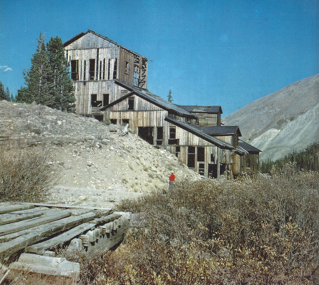
In the left foreground is the small bridge that was never listed in the B&B inventories. The siding at Leavick ran along the right side of the structure.
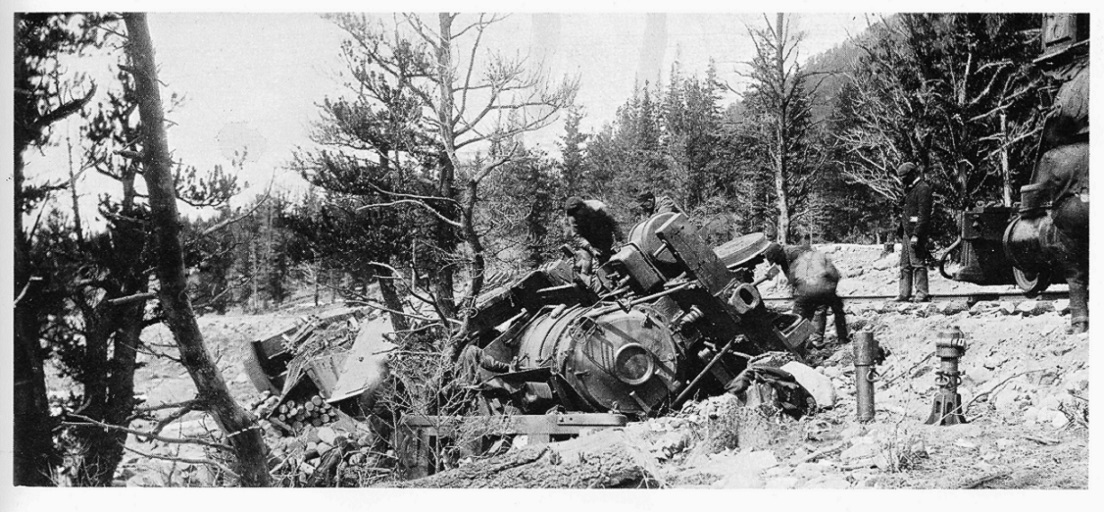
As to any photos of rail operations, that might lend a clue as to the location of any water tank, included are two good copies of photographs of the train wreck in 1897, By the oral history recorded by Poor, the location was likely just below Mudsill, where the train would normally stop for water.
The less-cropped photo looking west (upgrade) shows no sign of a water tank:
But the companion photo, looking downgrade to the east, might give a hint as to a water tank location:
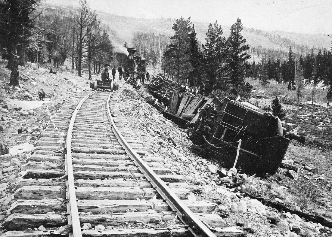
To the left of the distant locomotive, there appears to be a dark structure. Last night I enlarged this section, while sipping some of my "sanding" whiskey:
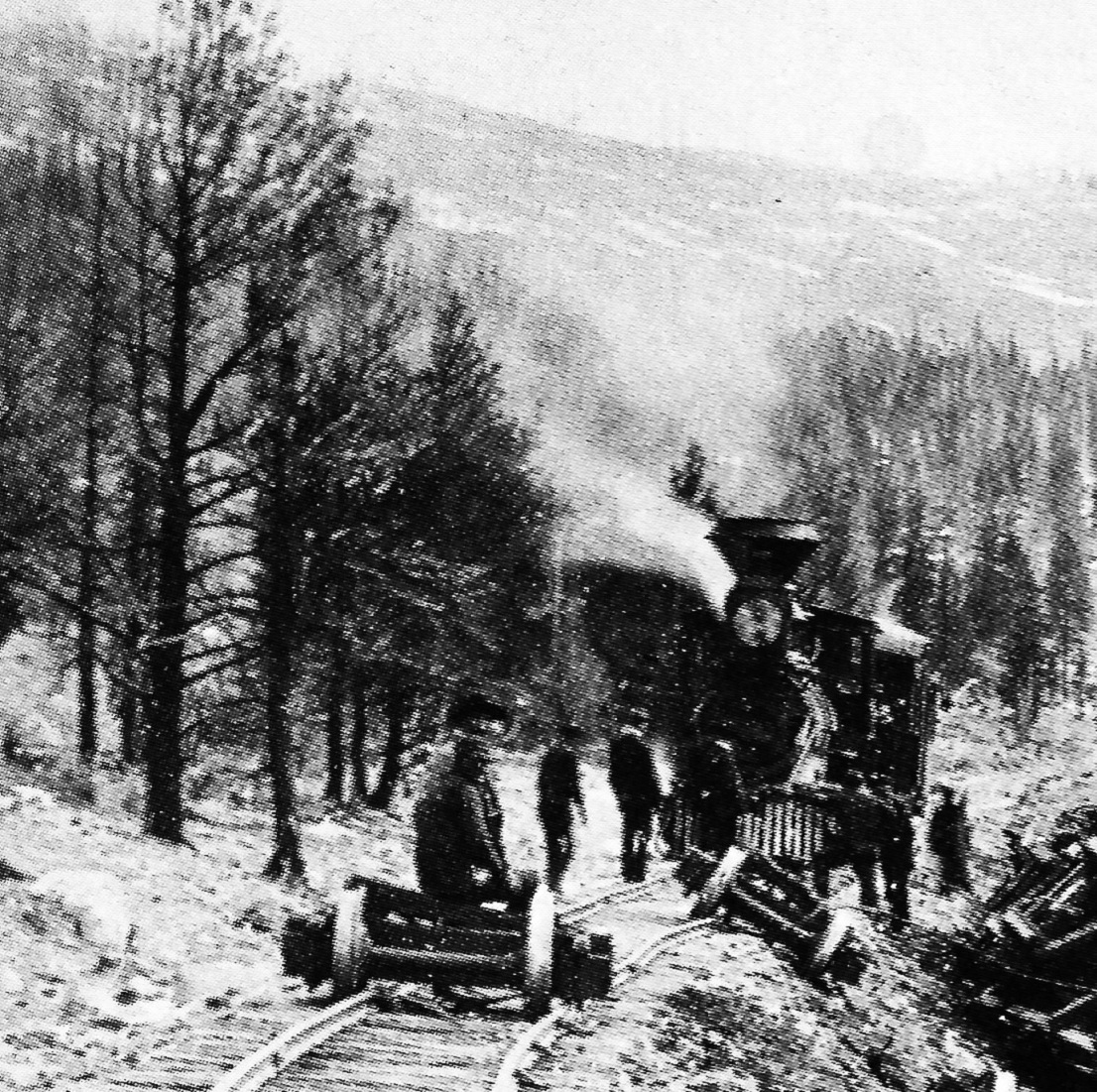
To my eye, the dark structure seems to have a conical roof with a center filial, hiding behind the steam from the locomotives whistle or blow-off cock. Or perhaps the whiskey helped me find what I wanted to find. You decide.
Admittedly, the structure seems set back too far from the track to have been a water tank. The map by Haley that Chris posted shows the "Dauntless Mine" located roughly in the same area, so the dark structure could be a building of that mining operation. If anyone has a high resolution copy of this photo, or knows of one online, that might further settle the matter.
So, I think it likely that Jeff's photo is a water tank (with a later flat topped roof) on the Leavick branch, the only place "near Fairplay" that it could be located. If so, I believe it would have been on the north side of the grade, just a bit down grade from Mudsill.
I remembered that I have several of the 1918 ICC valuation maps, that I purchased from the Colorado RR Museum. My map of the Garo-Alma section doesn't show anything of the Leavick branch, except Hill Top Jct. But not all 1918 ICC valuation maps were created equal. The Klingers' published this map from the 1918 valuation series in their Gunnison division book:
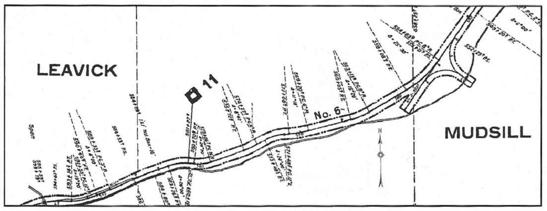
The little bridge and the siding at the Leavick Mill are at the left, lower corner. If that is Jeff's water tank in the second wreck photo, it would be located down grade from Mudsill, just off the map at the top right corner. If anyone has a copy of the 1918 maps that show the entire Leavick branch, there may be a water tank lurking in there.
Since Chris has established that the ties of the Mudsill wye still exist, a drive up there might give one a starting place to look for any evidence of the stone or timber footings for the "three bent tank", just down grade from the wye.
If Jeff's tank was built in 1896, by Trumbull's company, I think it is odd that they would follow standard plans for a UP era, small water tank. Maybe the drawings were still available in the DL&G files, so they just used those. Or maybe they just moved the tank up from Denver, as were other structures . . .
URL: http://c-sng-discussion-forum.254.s1.nabble.com/Mystery-Water-Tank-tp19563p19575.html
Chris and Matt,
Thanks for the additional info and photos.
Before Jeff posted the water tank photo and started this thread, I knew very little about the Leavick branch. It bugs me that the B&B book lists no structures or bridges on this stretch of railroad, as if it didn't exist. My understanding is that the DL&G B&B book was printed in 1894, probably derived from similar inventories from original South Park days. The original owner of Rick's copy thereafter updated the book for many years, crossing out structures destroyed by fire (the Alpine engine house, the Kokomo water tank, etc.) and hand writing in additions such as the coaling trestle at Dickey, with details including the little things like privy's.
I've kept reading in my book collection and in The Mineral Belt, Volume 2 by Digerness, I found several pages devoted to the Leavick Branch. Included was this brief history of construction:
Explains why there is no mention of the Leavick branch in the 1894 B&B book--it had not been built yet! As the branch was owned by Receiver Trumbull, it was never a part of the DL&G, nor added to the official inventory. When Trumbull sold the branch to the newly formed C&S, there was so much going on, that no one ever sat down and added any bridges or structures to the C&S inventory.
In the abandonment chapter of Poor's book, he cites a 1923 ICC report that all operations on the branch had ceased by that date, but the rails were not removed until the final system abandonment. When the Garos to Alma line was pulled up, the scrap train must have made one last trip up to Leavick.
Photos in Digerness's book include this photo of the Leavick Mill, probably in the 1960s:
In the left foreground is the small bridge that was never listed in the B&B inventories. The siding at Leavick ran along the right side of the structure.
As to any photos of rail operations, that might lend a clue as to the location of any water tank, included are two good copies of photographs of the train wreck in 1897, By the oral history recorded by Poor, the location was likely just below Mudsill, where the train would normally stop for water.
The less-cropped photo looking west (upgrade) shows no sign of a water tank:
But the companion photo, looking downgrade to the east, might give a hint as to a water tank location:
To the left of the distant locomotive, there appears to be a dark structure. Last night I enlarged this section, while sipping some of my "sanding" whiskey:
To my eye, the dark structure seems to have a conical roof with a center filial, hiding behind the steam from the locomotives whistle or blow-off cock. Or perhaps the whiskey helped me find what I wanted to find. You decide.
Admittedly, the structure seems set back too far from the track to have been a water tank. The map by Haley that Chris posted shows the "Dauntless Mine" located roughly in the same area, so the dark structure could be a building of that mining operation. If anyone has a high resolution copy of this photo, or knows of one online, that might further settle the matter.
So, I think it likely that Jeff's photo is a water tank (with a later flat topped roof) on the Leavick branch, the only place "near Fairplay" that it could be located. If so, I believe it would have been on the north side of the grade, just a bit down grade from Mudsill.
I remembered that I have several of the 1918 ICC valuation maps, that I purchased from the Colorado RR Museum. My map of the Garo-Alma section doesn't show anything of the Leavick branch, except Hill Top Jct. But not all 1918 ICC valuation maps were created equal. The Klingers' published this map from the 1918 valuation series in their Gunnison division book:
The little bridge and the siding at the Leavick Mill are at the left, lower corner. If that is Jeff's water tank in the second wreck photo, it would be located down grade from Mudsill, just off the map at the top right corner. If anyone has a copy of the 1918 maps that show the entire Leavick branch, there may be a water tank lurking in there.
Since Chris has established that the ties of the Mudsill wye still exist, a drive up there might give one a starting place to look for any evidence of the stone or timber footings for the "three bent tank", just down grade from the wye.
If Jeff's tank was built in 1896, by Trumbull's company, I think it is odd that they would follow standard plans for a UP era, small water tank. Maybe the drawings were still available in the DL&G files, so they just used those. Or maybe they just moved the tank up from Denver, as were other structures . . .
Jim Courtney
Poulsbo, WA
Poulsbo, WA
| Free forum by Nabble | Edit this page |