Re: The Gilpin Tram in Black Hawk
Posted by Keith Pashina on Apr 02, 2023; 2:37am
URL: http://c-sng-discussion-forum.254.s1.nabble.com/The-Gilpin-Tram-in-Black-Hawk-tp18436p18575.html
The Fullerton Mill Branch
At the Gilpin Tram’s engine house, if we looked north, we would have been peering over the runaround track and wye, and looking up Clear Creek at what was known as the Fullerton Mill Branch.
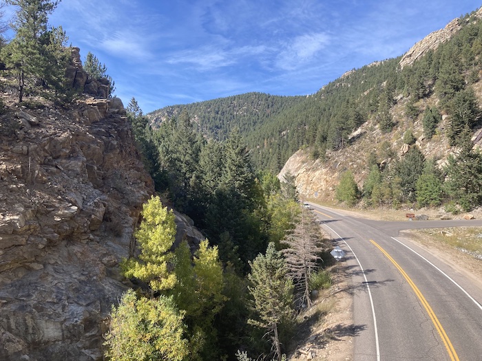
Looking north from the enginehouse site. The mainline up Chase Gulch and to the mines curved around the rock outcopping on the left side of the photo. Looking straight ahead, we are looking up Clear Creek Canyon, and the general route of the Gilpin Tram’s Fullerton Mill Branch.
M.P. 36.95 SWITCHBACK No. 1 (Engine House)
The Fullerton Mill branch officially began at the engine house, at milepost 36.95. This is where the mainline began its climb up Chase Gulch, the main headed downgrade to Black Hawk and several mills, and the trackage north went to more mills.
The Fullerton Mill Branch extended for about a mile to the northwest. The branch started out on the west side of Clear Creek, crossed over to the other side to reach two mills, then crossed back to the west side to reach the Martin/Wheeler Mill.
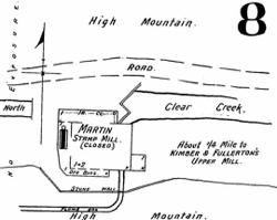
This branch was built to serve three ore-processing mills: the Golden Fleece/Brooklyn/Gunnell Gold M & M Company, the Fullerton Upper Mill, and the Martin/Wheeler Mill. The owners of the Martin/Wheeler Mill owned the trackage from “Martin Junction” at milepost 37.32, the to their mill, which was 2,693 feet of trackage, or about 0.51 miles.
The branch was built early in the life of the tram – newspaper records show the branch was in place to the Upper Fullerton Mill in 1887.
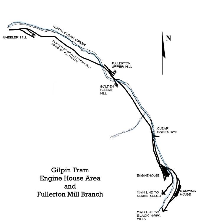
Map of the Gilpin Tram’s Fullerton Mill Branch
GOLDEN FLEECE/BROOKLYN/GUNNELL GOLD M & M COMPANY
This small mill was about 0.3 miles north of the engine house, although official records don’t document its location. I have never seen a photo of this mill, nor are there many records describing it. What we do know is that it started out known as the Golden Fleece Mill, maybe, although I don’t know this for sure, before the tram. Newspaper reports mention in processing ore from the Rialto Mine, in 1893 and 1894.
Later on, the mill was described as the Brooklyn Mill, then finally as the Gunnell Gold M & M Company. This latter name implies it was part of a larger conglomerate of the mines consolidated on Gunnell Hill.
The 1917 USGS Economic Geology of Gilpin County report stated this mill had 1 jaw crusher, 10 stamps, amalgamating tables, jigs, and Gilpin bumping tables.
The report describes this mill as still extant in 1917, but I don’t know when it quit operating.
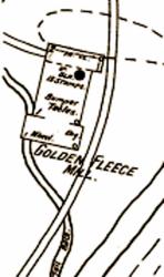
The 1895 Sanborn Fire Insurance Company map shows the Golden Fleece Mill, which was served by the Gilpin Tram.
The landscape in this area has been greatly changed since Gilpin Tram days. The highway construction has moved the creek to the west side of the canyon, and has been partially built over the old grade. However, the concrete foundations for the Golden Fleece/Brooklyn/Gunnell Gold M & M Company mill can still be found, now down in the creek bed. This area is heavily overgrown with underbrush, and in the summer, when the bushes are leafed out, almost impossible to find. My impression of the ruins was that the shape of the foundation was similar to what was depicted in the Sanborn Insurance Company map.
The general site of the Golden Fleece Mill is overgrown today. Road construction seems to have shifted Clear Creek further to the west side of the canyon, so that the foundations are very close to the creek and the soil eroded. Some of the concrete foundations of the mill can be found in the underbrush.
M.P. 37.31 UPPER FULLERTON MILL SPUR
This mill apparently had two spurs to it. The upper track was 728 feet long, according to Dan Abbott. Dan also reported that some maps described this spur as having one switchback before it reached the mill building. Over the years, this mill was variously known as the Gunnell Mill, St. Louis-Gunnell Mining and Milling Company, and the Kimball & Fullerton Upper Mill. Mine production records said the mill had a 30-ton ore capacity each 24 hours, and used 20 stamps. William Fullerton was a prominent mining man in the area, and built his first mill in 1867. He also owned the Gunnell Mine for a while, one of the largest producers in the area.
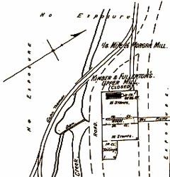
The 1895 Sanborn Fire Insurance Company map shows the Upper Fullerton Mill, which was served by the Gilpin Tram. Some maps show two spurs to the mill – one at the upper (right side), presumably to dump ore, and one near the base of the mill (left side).
Highway construction has obliterated the site, and there are no remains of it today. Also, I have never seen a photo of this mill.
There are very few records of this mill’s use, but it was used by the Tramway soon after railroad construction. The Weekly Register-Call, a Central City newspaper, reported some details on July 15, 1892:
The St. Louis-Gunnell Mining and Milling Company have placed sheet iron on their mill building, on North Clear Creek above Black Hawk, which has received a new coat of mineral paint. Before the water season is over and cold weather sets in, the company will secure a new steam boiler to supplant the upright boiler formerly in use. They will also widen the building on the east side, and add such other improvements to the premises as will better facilitate the milling of ore taken out by them from their group of mines on Gunnell hill this city. This will give them more room in which to store concentrates, and better facilitate the loading of the same into the Tramway company’s cars.
Since I built a model of this mill, I was interested in learning the mill was clad with sheet metal siding, painted mineral, which I would interpret to be a mineral red. Also, note the reference to Gilpin Tram cars being loaded. The article is also noting the upgraded boiler is needed to power the mill, which presumably used a water wheel to power the mill when Clear Creek had good water flow.
The same newspaper reported on August 25, 1893:
The main line of the Gilpin County tramway company is now extended to the Fullerton upper stamp mill, which is located only a short distance below. (note – the remainder of the news story is referring to the Wheeler Mill)
Note that within a year, the name reference changes from the Gunnell to the Fullerton mill. The news editor is loose on the name of the Gilpin Tram, too.
Things were busy here 8 years later, when the Gilpin County Observer reported on May 23, 1901:
Last week the Gunnell Gold Mining and Milling Company kept 80 stamps dripping on ore from the Gunnell and Grand Army shafts on Gunnell hill. This week they have kept 53 stamps dropping. The upper mill on North Clear creek, 33 stamps, is kept employed on ore from the workings of the Grand Army shaft.
I always thought stamps were used in group of 5 stamps per battery, but obviously not.
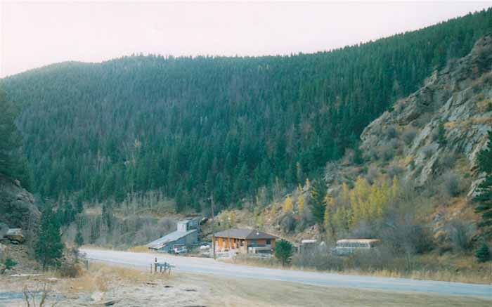
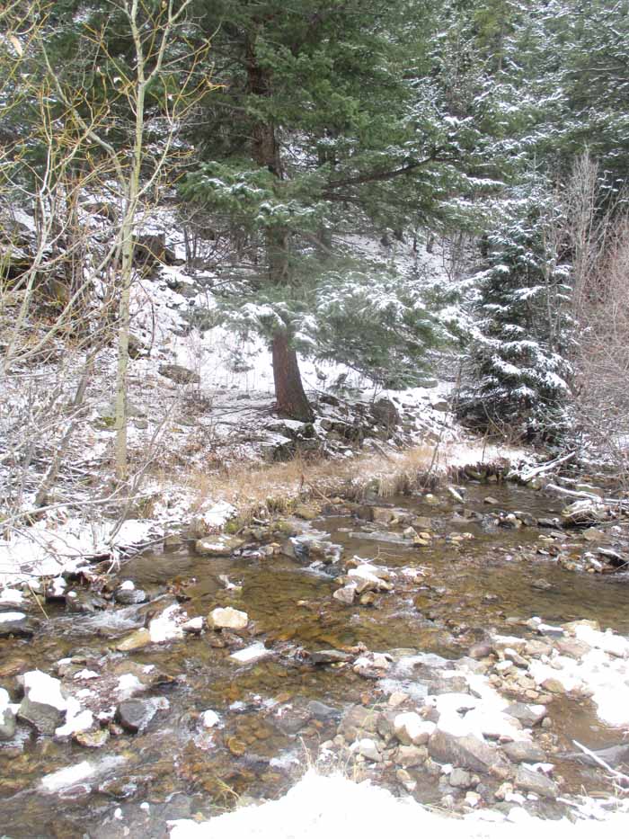
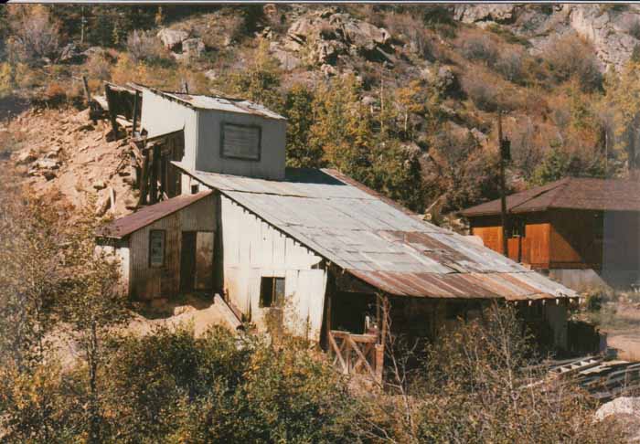
This is looking southeast in Clear Creek Canyon, and at the approximate location of the Martin/Wheeler Mill. The buildings here are not original to the Gilpin Tram. That is Highway 119 in the foreground.
M.P. 37.32 MARTIN JUNCTION
This junction was on what would probably be a switchback to the Upper Fullerton Mill spur, and was very close to this mill. A Mr. R.L. Martin owned this trackage, and it was used to reach his Martin/Wheeler Mill. R.L. Martin was a prominent mine and mill operator in the area, and he also owned the Gettysburg Mine, and I have seen his name mentioned with several other mining ventures.
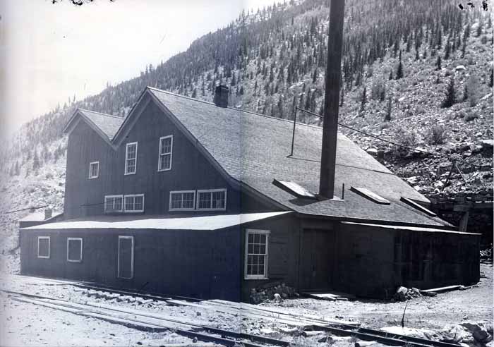
The Martin Mill, or better known as the Wheeler Mill. This photo courtesy of the Mark Baldwin collection. The branch grade is closest to the photographer, and there is a spur, perhaps to unload coal, next to the mill. I think there was an ore unloading spur on the opposite side of the mill, not shown in this photo. This is a very unusual building configuration for a mill, not typical of others in the area.
M.P. 37.77 WHEELER MILL (ON MARTIN’S EXTENSION)
The Martin/Wheeler Mill was also known as the Climax Mill at various times, according to Dan Abbott’s research and local newspaper accounts. An 1879 Mines Directory also lists this as the “Bostwick and Wheeler Mill.” But, the same report describes this as the “Wheeler Mill, owned by W. Wheeler and D. Sullivan” – I mention this to demonstrate how challenging it can be to track information on these operations – there were frequent changes.
This mill had 25 stamps and outside amalgamating tables, 5 Gilpin County bumping tables, and could handle 37 tons of ore each 24-hours.
The 1895 Sanborn Fire Insurance Company map shows the Wheeler Mill. The Gilpin Tram trackage is not shown
The Weekly Register-Call reported on the mill on August 25, 1893, and noted the mill was operated with a 28-foot diameter water wheel with an 8-foot face, fed with a 2’ x 3’ flume. The flume was being replaced with a new one, and workers were slightly altering the Clear Creek channel to make more room for concentrates storage. The stamps were of the “modern Gilpin County pattern” – more on that later. There was also a boiler and 35-horse power steam engine in use. The mill also had five “Gilt Edge concentrating or bumping tables”, too. And, of greatest interest to us:
The main line of the Gilpin County tramway company is now extended to the Fullerton upper stamp mill, which is located only a short distance below. This is a probability that this enterprise will be extended up the creek to the mill, should proper terms be made for the tramway company for transportation of the Climax mine to the mill.
Of course, we know track was eventually laid this mil. I think there were 2 spurs to this mill: one for coal unloading and supplies, and an upper track for presumably ore unloading. Both spurs faced south, so train movements would have required the train to pull the train up to the mill, then work the spurs. Since this branch is on a steep upgrade from the engine house, the shays must have put on a good show when switching the mill!
The mill is on or near the former Wheeler Mill site. It was built sometime after the Gilpin Tram ceased operations, and this particular structure was demolished perhaps 15 years ago.
The Gilpin Observer reported on August 31, 1899, that the mill was being overhauled, still a 25-stamp mill and the mill still used water power whenever the creek flowed, and mentioned:
“…is connected with the main track of the Gilpin County tramway.”
I could find no detailed records of shipments or traffic to this mill. By 1917, this mill was reported as being partially dismantled. When the mill quit operating is unknown.
We are fortunate to have a photo of this mill. Mark Baldwin, who also hosts the Gilpin Gold Tram website, gave permission to use this photo. This mill is looks very different from the typical mills in the area – it seems to be a wood-framed building with peaked, shingled roofs.
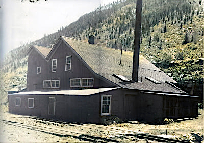
This is the photo from the Mark Baldwin collection, which was colorized by my photo software program. I don’t know if the colors are realistic or not, but to me, this helps hring the structure to life. This would make a unique and very interesting model.
URL: http://c-sng-discussion-forum.254.s1.nabble.com/The-Gilpin-Tram-in-Black-Hawk-tp18436p18575.html
The Fullerton Mill Branch
At the Gilpin Tram’s engine house, if we looked north, we would have been peering over the runaround track and wye, and looking up Clear Creek at what was known as the Fullerton Mill Branch.
Looking north from the enginehouse site. The mainline up Chase Gulch and to the mines curved around the rock outcopping on the left side of the photo. Looking straight ahead, we are looking up Clear Creek Canyon, and the general route of the Gilpin Tram’s Fullerton Mill Branch.
M.P. 36.95 SWITCHBACK No. 1 (Engine House)
The Fullerton Mill branch officially began at the engine house, at milepost 36.95. This is where the mainline began its climb up Chase Gulch, the main headed downgrade to Black Hawk and several mills, and the trackage north went to more mills.
The Fullerton Mill Branch extended for about a mile to the northwest. The branch started out on the west side of Clear Creek, crossed over to the other side to reach two mills, then crossed back to the west side to reach the Martin/Wheeler Mill.
This branch was built to serve three ore-processing mills: the Golden Fleece/Brooklyn/Gunnell Gold M & M Company, the Fullerton Upper Mill, and the Martin/Wheeler Mill. The owners of the Martin/Wheeler Mill owned the trackage from “Martin Junction” at milepost 37.32, the to their mill, which was 2,693 feet of trackage, or about 0.51 miles.
The branch was built early in the life of the tram – newspaper records show the branch was in place to the Upper Fullerton Mill in 1887.
Map of the Gilpin Tram’s Fullerton Mill Branch
GOLDEN FLEECE/BROOKLYN/GUNNELL GOLD M & M COMPANY
This small mill was about 0.3 miles north of the engine house, although official records don’t document its location. I have never seen a photo of this mill, nor are there many records describing it. What we do know is that it started out known as the Golden Fleece Mill, maybe, although I don’t know this for sure, before the tram. Newspaper reports mention in processing ore from the Rialto Mine, in 1893 and 1894.
Later on, the mill was described as the Brooklyn Mill, then finally as the Gunnell Gold M & M Company. This latter name implies it was part of a larger conglomerate of the mines consolidated on Gunnell Hill.
The 1917 USGS Economic Geology of Gilpin County report stated this mill had 1 jaw crusher, 10 stamps, amalgamating tables, jigs, and Gilpin bumping tables.
The report describes this mill as still extant in 1917, but I don’t know when it quit operating.
The 1895 Sanborn Fire Insurance Company map shows the Golden Fleece Mill, which was served by the Gilpin Tram.
The landscape in this area has been greatly changed since Gilpin Tram days. The highway construction has moved the creek to the west side of the canyon, and has been partially built over the old grade. However, the concrete foundations for the Golden Fleece/Brooklyn/Gunnell Gold M & M Company mill can still be found, now down in the creek bed. This area is heavily overgrown with underbrush, and in the summer, when the bushes are leafed out, almost impossible to find. My impression of the ruins was that the shape of the foundation was similar to what was depicted in the Sanborn Insurance Company map.
The general site of the Golden Fleece Mill is overgrown today. Road construction seems to have shifted Clear Creek further to the west side of the canyon, so that the foundations are very close to the creek and the soil eroded. Some of the concrete foundations of the mill can be found in the underbrush.
M.P. 37.31 UPPER FULLERTON MILL SPUR
This mill apparently had two spurs to it. The upper track was 728 feet long, according to Dan Abbott. Dan also reported that some maps described this spur as having one switchback before it reached the mill building. Over the years, this mill was variously known as the Gunnell Mill, St. Louis-Gunnell Mining and Milling Company, and the Kimball & Fullerton Upper Mill. Mine production records said the mill had a 30-ton ore capacity each 24 hours, and used 20 stamps. William Fullerton was a prominent mining man in the area, and built his first mill in 1867. He also owned the Gunnell Mine for a while, one of the largest producers in the area.
The 1895 Sanborn Fire Insurance Company map shows the Upper Fullerton Mill, which was served by the Gilpin Tram. Some maps show two spurs to the mill – one at the upper (right side), presumably to dump ore, and one near the base of the mill (left side).
Highway construction has obliterated the site, and there are no remains of it today. Also, I have never seen a photo of this mill.
There are very few records of this mill’s use, but it was used by the Tramway soon after railroad construction. The Weekly Register-Call, a Central City newspaper, reported some details on July 15, 1892:
The St. Louis-Gunnell Mining and Milling Company have placed sheet iron on their mill building, on North Clear Creek above Black Hawk, which has received a new coat of mineral paint. Before the water season is over and cold weather sets in, the company will secure a new steam boiler to supplant the upright boiler formerly in use. They will also widen the building on the east side, and add such other improvements to the premises as will better facilitate the milling of ore taken out by them from their group of mines on Gunnell hill this city. This will give them more room in which to store concentrates, and better facilitate the loading of the same into the Tramway company’s cars.
Since I built a model of this mill, I was interested in learning the mill was clad with sheet metal siding, painted mineral, which I would interpret to be a mineral red. Also, note the reference to Gilpin Tram cars being loaded. The article is also noting the upgraded boiler is needed to power the mill, which presumably used a water wheel to power the mill when Clear Creek had good water flow.
The same newspaper reported on August 25, 1893:
The main line of the Gilpin County tramway company is now extended to the Fullerton upper stamp mill, which is located only a short distance below. (note – the remainder of the news story is referring to the Wheeler Mill)
Note that within a year, the name reference changes from the Gunnell to the Fullerton mill. The news editor is loose on the name of the Gilpin Tram, too.
Things were busy here 8 years later, when the Gilpin County Observer reported on May 23, 1901:
Last week the Gunnell Gold Mining and Milling Company kept 80 stamps dripping on ore from the Gunnell and Grand Army shafts on Gunnell hill. This week they have kept 53 stamps dropping. The upper mill on North Clear creek, 33 stamps, is kept employed on ore from the workings of the Grand Army shaft.
I always thought stamps were used in group of 5 stamps per battery, but obviously not.
This is looking southeast in Clear Creek Canyon, and at the approximate location of the Martin/Wheeler Mill. The buildings here are not original to the Gilpin Tram. That is Highway 119 in the foreground.
M.P. 37.32 MARTIN JUNCTION
This junction was on what would probably be a switchback to the Upper Fullerton Mill spur, and was very close to this mill. A Mr. R.L. Martin owned this trackage, and it was used to reach his Martin/Wheeler Mill. R.L. Martin was a prominent mine and mill operator in the area, and he also owned the Gettysburg Mine, and I have seen his name mentioned with several other mining ventures.
The Martin Mill, or better known as the Wheeler Mill. This photo courtesy of the Mark Baldwin collection. The branch grade is closest to the photographer, and there is a spur, perhaps to unload coal, next to the mill. I think there was an ore unloading spur on the opposite side of the mill, not shown in this photo. This is a very unusual building configuration for a mill, not typical of others in the area.
M.P. 37.77 WHEELER MILL (ON MARTIN’S EXTENSION)
The Martin/Wheeler Mill was also known as the Climax Mill at various times, according to Dan Abbott’s research and local newspaper accounts. An 1879 Mines Directory also lists this as the “Bostwick and Wheeler Mill.” But, the same report describes this as the “Wheeler Mill, owned by W. Wheeler and D. Sullivan” – I mention this to demonstrate how challenging it can be to track information on these operations – there were frequent changes.
This mill had 25 stamps and outside amalgamating tables, 5 Gilpin County bumping tables, and could handle 37 tons of ore each 24-hours.
The 1895 Sanborn Fire Insurance Company map shows the Wheeler Mill. The Gilpin Tram trackage is not shown
The Weekly Register-Call reported on the mill on August 25, 1893, and noted the mill was operated with a 28-foot diameter water wheel with an 8-foot face, fed with a 2’ x 3’ flume. The flume was being replaced with a new one, and workers were slightly altering the Clear Creek channel to make more room for concentrates storage. The stamps were of the “modern Gilpin County pattern” – more on that later. There was also a boiler and 35-horse power steam engine in use. The mill also had five “Gilt Edge concentrating or bumping tables”, too. And, of greatest interest to us:
The main line of the Gilpin County tramway company is now extended to the Fullerton upper stamp mill, which is located only a short distance below. This is a probability that this enterprise will be extended up the creek to the mill, should proper terms be made for the tramway company for transportation of the Climax mine to the mill.
Of course, we know track was eventually laid this mil. I think there were 2 spurs to this mill: one for coal unloading and supplies, and an upper track for presumably ore unloading. Both spurs faced south, so train movements would have required the train to pull the train up to the mill, then work the spurs. Since this branch is on a steep upgrade from the engine house, the shays must have put on a good show when switching the mill!
The mill is on or near the former Wheeler Mill site. It was built sometime after the Gilpin Tram ceased operations, and this particular structure was demolished perhaps 15 years ago.
The Gilpin Observer reported on August 31, 1899, that the mill was being overhauled, still a 25-stamp mill and the mill still used water power whenever the creek flowed, and mentioned:
“…is connected with the main track of the Gilpin County tramway.”
I could find no detailed records of shipments or traffic to this mill. By 1917, this mill was reported as being partially dismantled. When the mill quit operating is unknown.
We are fortunate to have a photo of this mill. Mark Baldwin, who also hosts the Gilpin Gold Tram website, gave permission to use this photo. This mill is looks very different from the typical mills in the area – it seems to be a wood-framed building with peaked, shingled roofs.
This is the photo from the Mark Baldwin collection, which was colorized by my photo software program. I don’t know if the colors are realistic or not, but to me, this helps hring the structure to life. This would make a unique and very interesting model.
Keith Pashina
Narrow-minded in Arizona
Narrow-minded in Arizona
| Free forum by Nabble | Edit this page |