This One's A Gem: I.S.Yard Limits Begin.
Posted by Chris Walker on Mar 01, 2015; 12:10pm
URL: http://c-sng-discussion-forum.254.s1.nabble.com/This-One-s-A-Gem-I-S-Yard-Limits-Begin-tp1521.html
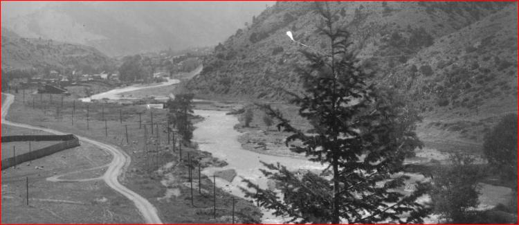
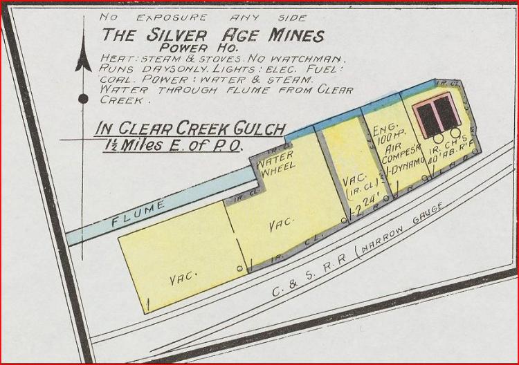
Yard Limits for Idaho Springs began M.P. 35.39, then a double-ended siding at Milepost #36 and a single-ended siding connected at the East-end, known as the Gem on the C&S Idaho Springs Yard Map 1929, and called the Silver Age on Sanborn Maps 1895(Concentrator) +1908(Powerhouse). Gem Mines Co. was very active around Clear Creek and Gilpin Counties. One I'd like to find out more on but never seen a picture of this site yet, none of the volumes written on the C&S mention this spot....The Wilkie Mill was on the South bank of Clear Creek opposite the Gem. Note, the I.S.P.O. did move locations during this period.

Hiding right behind that Tree. Gilson Gulch is to the right. This is close to where the 6&40 Motel is today. Damned Tree.
http://digital.denverlibrary.org/cdm/fullbrowser/collection/p15330coll22/id/3359/rv/singleitem/rec/9
http://libcudl.colorado.edu:8180/luna/servlet/UCBOULDERCB1~21~21


URL: http://c-sng-discussion-forum.254.s1.nabble.com/This-One-s-A-Gem-I-S-Yard-Limits-Begin-tp1521.html
Yard Limits for Idaho Springs began M.P. 35.39, then a double-ended siding at Milepost #36 and a single-ended siding connected at the East-end, known as the Gem on the C&S Idaho Springs Yard Map 1929, and called the Silver Age on Sanborn Maps 1895(Concentrator) +1908(Powerhouse). Gem Mines Co. was very active around Clear Creek and Gilpin Counties. One I'd like to find out more on but never seen a picture of this site yet, none of the volumes written on the C&S mention this spot....The Wilkie Mill was on the South bank of Clear Creek opposite the Gem. Note, the I.S.P.O. did move locations during this period.
Hiding right behind that Tree. Gilson Gulch is to the right. This is close to where the 6&40 Motel is today. Damned Tree.
http://digital.denverlibrary.org/cdm/fullbrowser/collection/p15330coll22/id/3359/rv/singleitem/rec/9
http://libcudl.colorado.edu:8180/luna/servlet/UCBOULDERCB1~21~21
UpSideDownC
in New Zealand
in New Zealand
| Free forum by Nabble | Edit this page |