Stanley Mills: Part Two. Salisbury Mill and Donna Juanita Mine.

Stanley Mills: Part Two. Salisbury Mill and Donna Juanita Mine.

|
This post was updated on .
Out past the Western end of Idaho Springs was a place called Spanish Bar named back in the days when the Clear Creek was being Placer mined. Once the sluice miners moved on further upstream to richer "diggings" the hardrock miners moved in and laid claim to this area that later came to be known as Stanley Mills on the C&S.
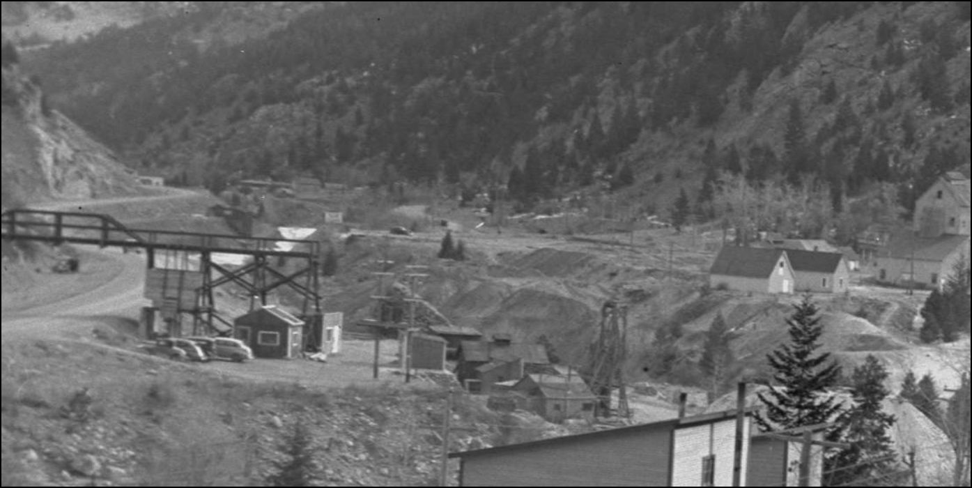
Here there were a number of mines and a couple of smelters were established. Both these buildings were re-purposed by seperate mining companies and as a tease, those will be detailed in the conclusion of this area, Stanley Mills: Part Three. Two Smelters and the Consolidated Stanley Mines. The Salisbury Mill and the mine drive is on the right near the Boarding house. The C&S Bridge #39 formerly numbered 716 can be seen in the middle distance with the settlement of Stanley Mills and the Lincoln Group of mines farther back. This Mill may have survived unused in later years right up until the abandonment of the C&S here. The 351Ft double ended siding here at Mp 38.91 was shown on the C&S Railway Trackage map of 1923/1929. At least until 1936 as shown in Mal Ferrell's RB Jackson photograph.  DPL McClure photo MCC-368. http://digital.denverlibrary.org/cdm/fullbrowser/collection/p15330coll22/id/77738/rv/singleitem/rec/16 In this picture you can see an additional tram trestle from the Southside of Clear Creek, this came from the Old Stanley(Plutus) Mine adjacent the Salisbury Mine on the Northside.  Lachlan McLean Photo: Idaho Springs Historical Society Coll. Inside the Salisbury Mill in 1895. 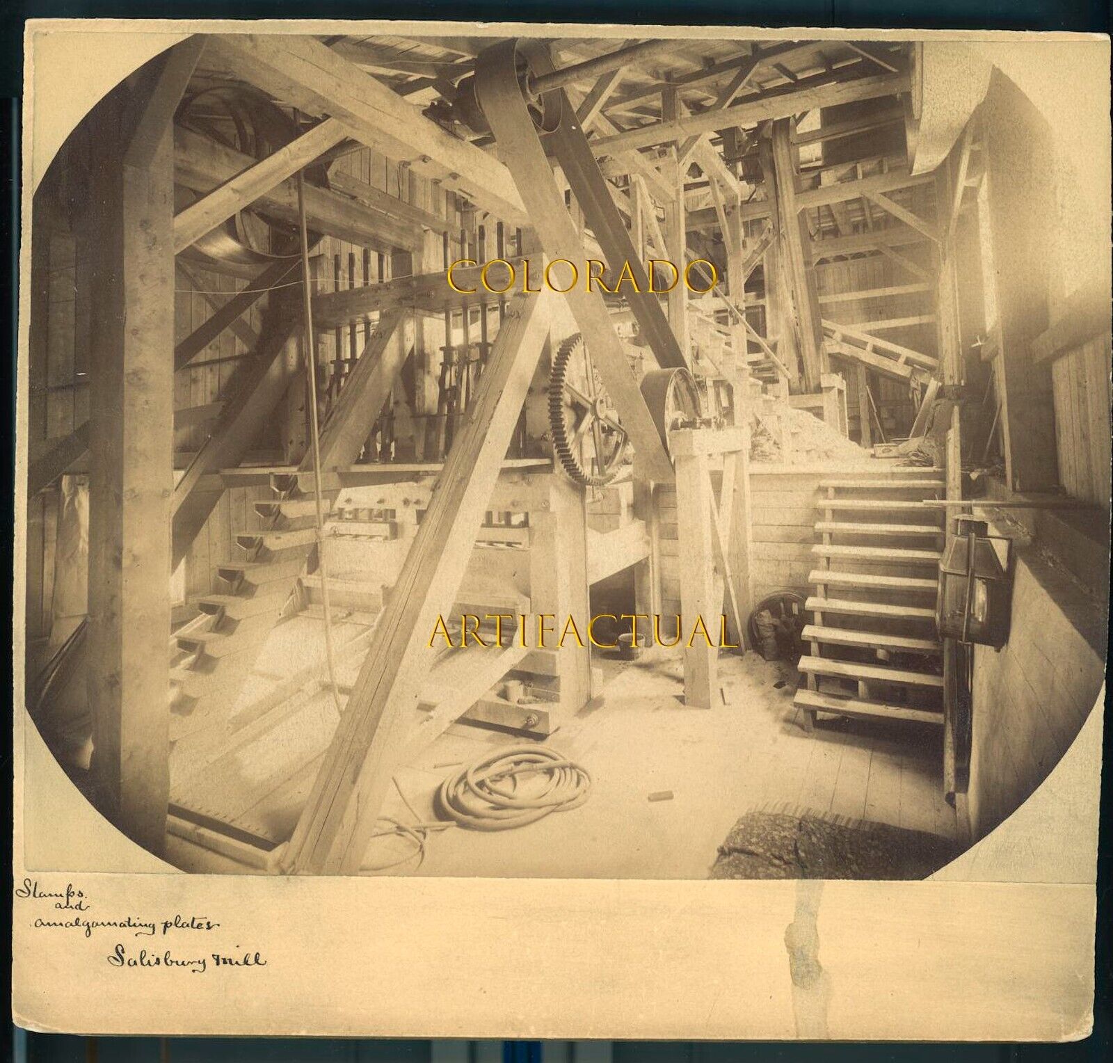 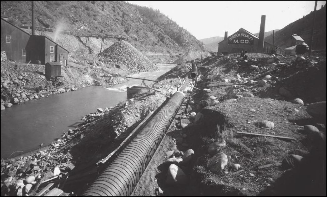 Lachlan McLean Photo: Idaho Springs Historical Society Coll. 1891 Sanborn 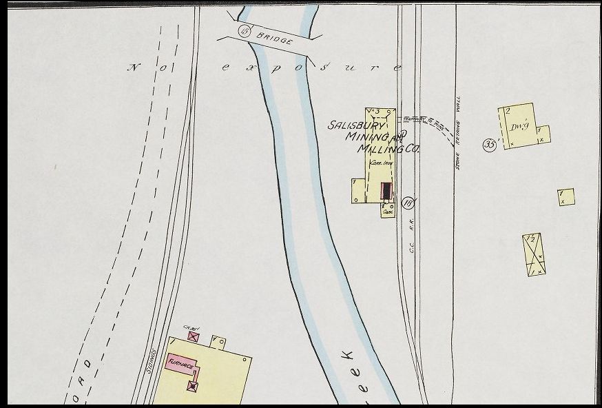 In this picture offered on Ebay, a Lachlan McLean photo also shown pg321 of the Sundance Colorado Central Rail Road book by Abbott: Note the boxcar on Salisbury Mill siding, this siding does appear to have been removed by 1936 in Mal's picture shown next.  In this rather neat R.B.Jackson picture we see the #70 and a short freight crossing the #39 Bridge in 1936, the same bridge that Harry Brunk so nicely modelled and wrote about in the May/June 1985 NG&SL Gazette. Here are the important clues: Note on the left there is no visible minetrestle over a roadway/highway but on the hillside a minedump can be seen. In the background sits the Salisbury Mill but the wastedump behind the Mill building isn't visible. The unusal braced headframe has an oretrestle crossing the C&S mainline to another wastedump alongside the Clear Creek. Note also the height difference between the railroad and stream. 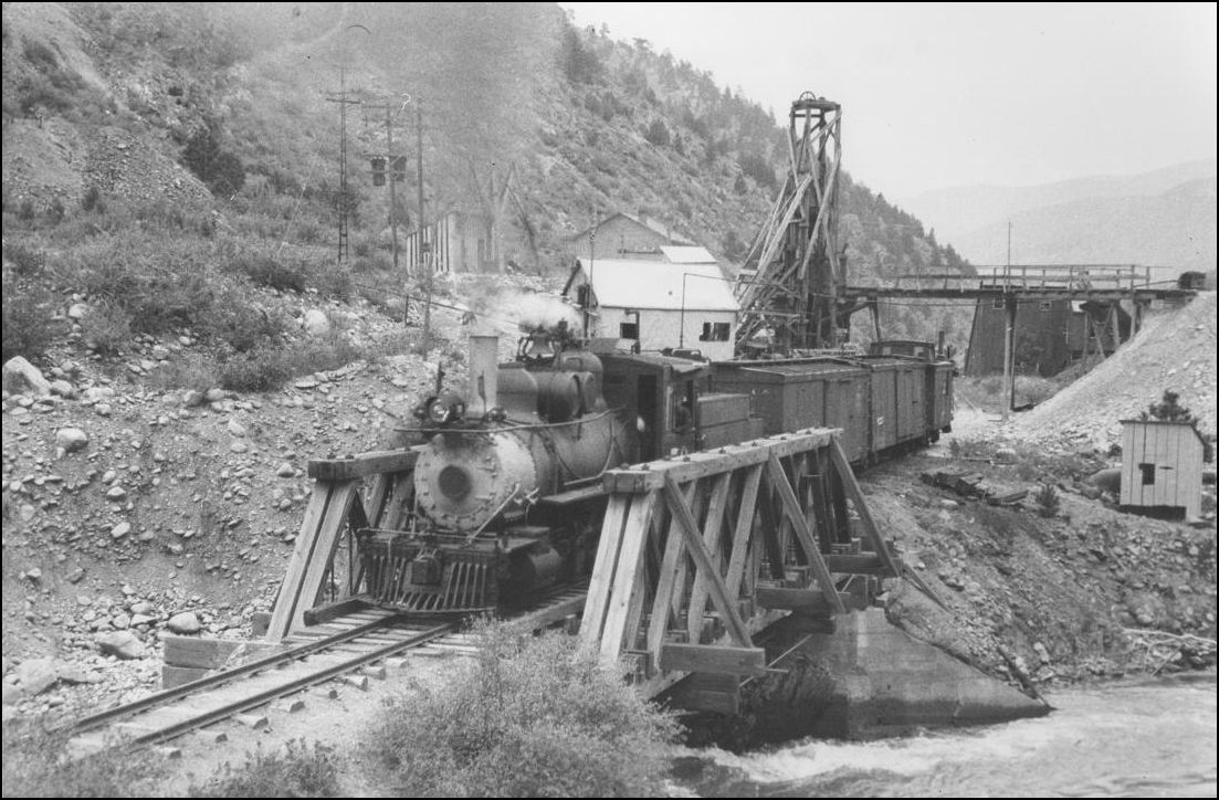 Courtesy of Mal Ferrell, R.B.Jackson photo from C&Sng: Colorado & Southern Narrow Gauge. It is this picture that now brings us to the Donna Juanita Mine. Harry Brunk described his model of the "Hukill" mine in the Jul/Aug 1985 NG&SL Gazette, but did not mention why he used that name. I wonder if it was first used mistakenly by Digerness in Mineral Belt Vol. III, but Harry went on in a later issues (Mar/Apr and May/Jun '95 Gazettes) to call it the Maude Monroe. However searching the USGS has revealed the true name of the Donna Juanita which had two openings on the vein, #18 a horizontal adit or minedrive on the Southside of Clear Creek and #17 the Orange Shaft Headframe and Orebins we know today and still refered to as the Hukill/Maude Monroe.  While on this Topomap(1966) from the USGS, I'd like to point out the #8 minedrive, the true location of the Maude Monroe that is above the grade of the 6&40 Highway, the Dump appearing in the top left corner of Mal's Jackson picture. The Hwy isn't visible there alongside the C&S #70 so I would be guessing that the improved highway West of Idaho Springs was post-1936. I base this on the Stanley Road was at that time the main wagon road to Georgetown, the Crockett and Salisbury properties being serviced by the minor road shown in the DPL McClure photo MCC-368. Will the real Maude Monroe please stand up. 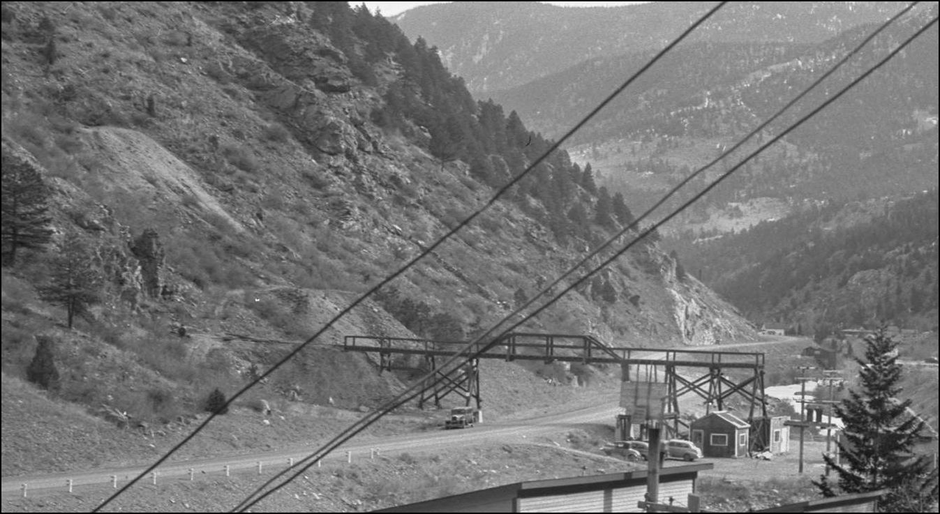 http://digital.denverlibrary.org/cdm/fullbrowser/collection/p15330coll21/id/11494/rv/singleitem/rec/270 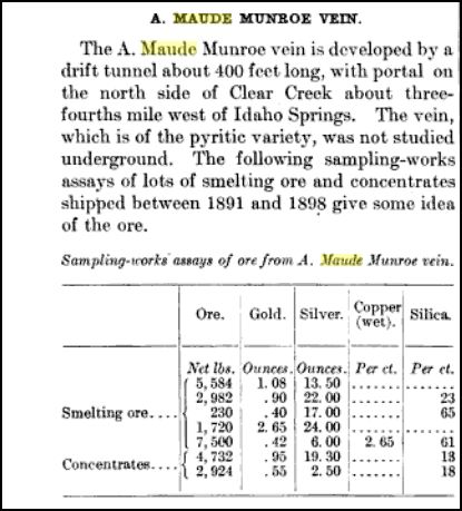 from the UGSG 1917 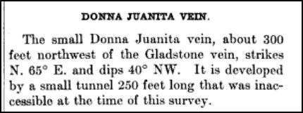 from the USGS 1917 Returning to the May/Jun '95 Gazette, Harry must've suspected all was not as it seemed with this Orange Headframe as he wrote, "...Even as I built the model of the mine head and ore bins, and first wrote about what was there in the pages of the GAZETTE, I had some doubts about whether it belonged in the era I am modeling -- the late 1920s and early 1930s. .... But what time? Back when the trains still ran? The only thing from that period that resembles the A-frame structure of the Maude Monroe shows up in a photo taken in 1936 by Richard B. Jackson. .... and the location seems about right. The structure shown, however, has a more primitive, unsophisticated look. The ore bins are either missing or are considerably smaller, so small that I can't detect them in the photo." With those words eching in my mind I noted several details to help pinpoint my view that the Headframe shown in the R B Jackson view was not the Headframe we see today during the time of the C&S, but came later in the 1940's during a resurgence probably after WW-2 (Executive order L-208) and these can be confirmed by careful examination of the background in several photographs. Taken from the Alma-Lincoln Mill grounds, this picture reveals several clues to show this older exploration type headframe continued to exist after the C&S. Now visible is the improved highway, the trestle across to the Maude Monroe and its small orebin incorporated into the trestlebents, note the concrete pillar supports. The Salisbury Mill has been demolished allowing us to see the wastedump now visible directly behind the twin Transformers (which also have been upgraded), the Headframe trestle to the waste dump of the Donna J. that crossed the C&S is also missing. Unfortunately in both the two shots taken from the Alma-Lincoln, the Mill towers obscure the Bridge #39. In the far distance there is also another Orebin that appears to be situated directly on the C&S grade, not serving the railroad either but road vehicles as the chutegates are not far above the creek, this building has not shown up in any other picture so far. Add into this scene no visible trackage which by all appearance gives me the impression this picture is post abandonment.  http://digital.denverlibrary.org/cdm/fullbrowser/collection/p15330coll21/id/11495/rv/singleitem/rec/271 This enlargement of the later picture, post burning of the Alma-Lincoln Mill about 1950 which shows the newer production Headframe with combined Orebins, note the location of the Hoisthouse adjacent to the Transformers and the height that the Headframe sits above the creek.  DPL X-3506 http://digital.denverlibrary.org/cdm/fullbrowser/collection/p15330coll22/id/6198/rv/singleitem/rec/304 EDIT: This next photo (about 1905: extant Mayflower Mine buildings near the Stanley Powerhouse and the Alpine/Bertha near the I.S. Water Tank) just confirms the wagon road location on the North bank of Clear Cr. up past the Maude and that the new 6&40 highway was built over the C&S grade from the Big5 Tunnel area to nearly as far as the Stanley Powerhouse. The "orebin in the distance" refered to was actually on the old wagon road not that of the C&S grade. 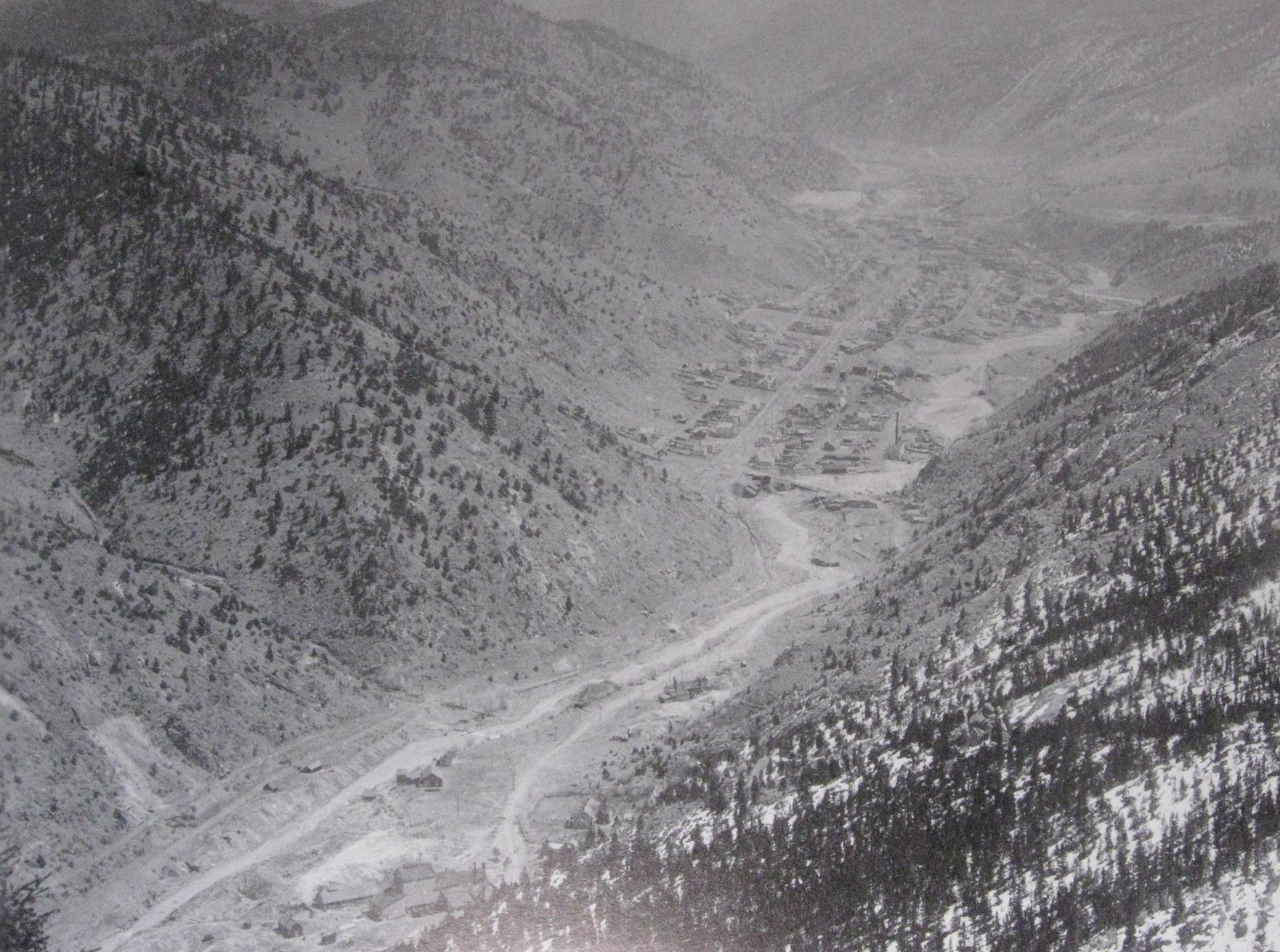 Lachlan McLean photo from Secure the Shadow: Lachlan McLean Colorado Mining Photographer, Smith & Wieler, CSM Press I now invite Ken Martin to share his postcard of the Donna Juanita, the Alma Lincoln Mill still extant in the background but the Maude Monroe orebin is missing from the trestle over the road. This picture also confirms that the Orange paint was applied before the Mill burned about 1950, something that was not apparent to me in the DPL X-3506.
UpSideDownC
in New Zealand |
Re: Stanley Mills: Part Two. Salisbury Mill and Donna Juanita Mine.
|
|
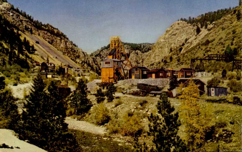
Here is a color postcard I found of the mine.
|
Re: Stanley Mills: Part Two. Salisbury Mill and Donna Juanita Mine.
|
|
> Here is a color postcard I found of the mine.
Outstanding! (Who would have guessed it was so colourful?) Cheers, Jeff. |
Re: Stanley Mills: Part Two. Salisbury Mill and Donna Juanita Mine.
|
|
This post was updated on .
I have edited the first post to reflect the addition of the photo I couldn't find when composing said post. This photo (about 1905: extant Mayflower Mine buildings near the Stanley Powerhouse and the Alpine/Bertha near the I.S. Water Tank) just confirms the wagon road location on the North bank of Clear Cr. up past the Maude and that the new 6&40 highway was built over the C&S grade from the Big5 Tunnel area to nearly as far as the Stanley Powerhouse. The "orebin in the distance" refered to was actually on the old wagon road not that of the C&S grade. Definitely Post C&S.
Thanks Ken for your postcard inclusion. That also shows the M Monroe trestle over 6&40 had been reduced by one span at the end and the odd looking Orebin removed. They seemed to have gone to some trouble with little to show for it.
UpSideDownC
in New Zealand |
Re: Stanley Mills: Part Two. Salisbury Mill and Donna Juanita Mine.
|
|
This post was updated on .
While revisiting the Donna Juanita some of my interpretations of the dating of these two pictures in the initial post hasn't sat well with me in regards to the existance of the new Hwy6&40 and the C&S prior to abandonment so I have looked back over this.
 http://digital.denverlibrary.org/cdm/fullbrowser/collection/p15330coll21/id/11495/rv/singleitem/rec/271 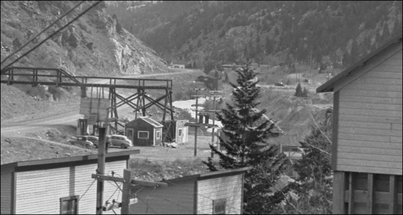 http://digital.denverlibrary.org/cdm/fullbrowser/collection/p15330coll21/id/11494/rv/singleitem/rec/270 Noting the amount of Tailings that have fouled the mainline here are visible in Alma-Lincoln Mill photos shown in Stanley Mills: Part One, especially when viewed in conjunction with this next R.H. Kindig picture. Those tailings do not appear to be over the tracks at the Bridge #16 shown in the C&S Valuation Survey 1939 photo on pg324 Abbott/McLeod Colorado Central Rail Road, Sundance Publications. My doubts were raised as in this R.H Kindig Aug 5th, 1938 photo, there clearly are two vehicles on the newly reconstructed highway while the last trains were running. 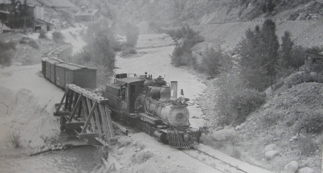 from pg301 David S. Digerness Mineral Belt Vol-3 Sundance Publications 1982 R.H.Kindig photo. Looking East and taken opposite the outlet of Trail Creek, former site of the Plutus Mill: note what looks like fresh asphalt on the Highway. 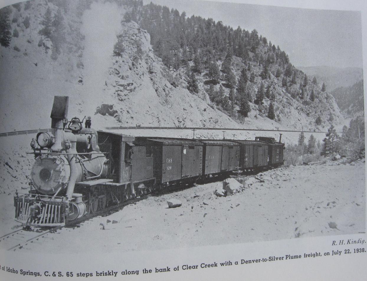 from Pictorial Supt. to D.S.P.&P. Cross-checking with CRRA #10 Narrow Gauge to Central and Silver Plume show photos and in Mineral Belt V-3 another, of the new highway and relocated C&S tracks near Blackhawk and Smith Hill prior to abandonment, thus raising the query. Could the C&S mainline immediately West of Idaho Springs been moved to allow construction of the new highway section and relaid alongside on the same grade as far as the Maude Monroe and Donna Juanita mines? This seems to be a bit of a stretch that the Hwy Dept. would do such but then again public money is easily spent. There apparently was considerable grade differences between the new Highway and the C&S tracks in this area, in the background of the Maude Monroe trestle there appears a newish constructed Orebin on what I assume to be the edge of the C&S grade with a Shed structure actually on the grade with little clearance between the new Highway fill. So any change of grade between sections especially where the new road bulges into Clear Creek at the former location of the Salisbury and Crockett mines should be apparent in the above enlargements. From that re-affirmation I can't see the C&S being operational at the time of those two DPL picture were taken.  EDIT:UPDATE The shed structure referred to above is the Beauzy Mine. source:USGS 1917. Perhaps someone-else will have an additional picture taken in this area in their collection or maybe Tom Klingers new book on the Clear Creek will produce something new.
UpSideDownC
in New Zealand |
«
Return to C&Sng Discussion Forum
|
1 view|%1 views
| Free forum by Nabble | Edit this page |