New Alpine Tunnel Book + Platte Canyon Construction Question...

Previous Topic Next Topic
 
classic Classic list List threaded Threaded
15 messages Options
Reply | Threaded
Open this post in threaded view
|

New Alpine Tunnel Book + Platte Canyon Construction Question...

chtrout
This post was updated on .
For those of you who have not seen it yet, author Michael Brown has just published a new volume entitled "Across the Great Divide – the History of the Alpine Tunnel in Images," which if I understand correctly, just came out in September 2019.


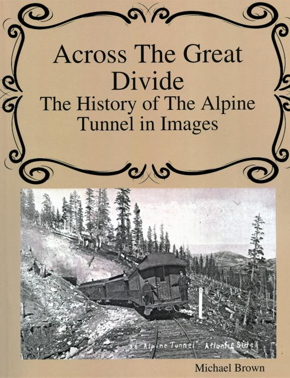
The book consists of (128) pages, with only (4) pages involving any text, the rest simply being a compilation of various photographs and station layout diagrams, approximately 90% of which have been seen previously in other publications.  The title is somewhat misleading in that the book actually covers the entire South Park line to Gunnison and beyond, and relatively few pages are dedicated to Alpine Pass and the tunnel itself.  The reproduction values are fairly good, and the main positive point on this book is seeing all of these many photographs collected together in one volume.  The gentle criticism I would make is that most captions only consist of several words at most, and very few photos are accredited to their original photographer, or to the collection from which they were derived.

The book is readily available on Amazon.com and other sources in paperback at about $18.95.  I do recommend this book, but also recommend that you manage your expectations in terms of hoping to add any detailed information to your reference library.

- - -
                                 
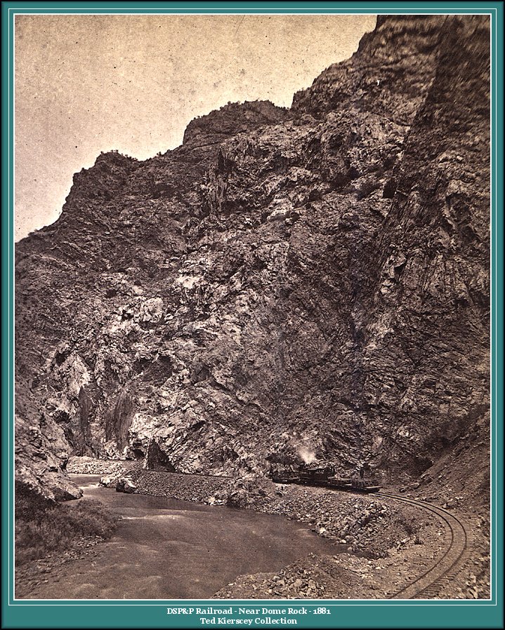
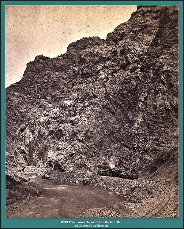
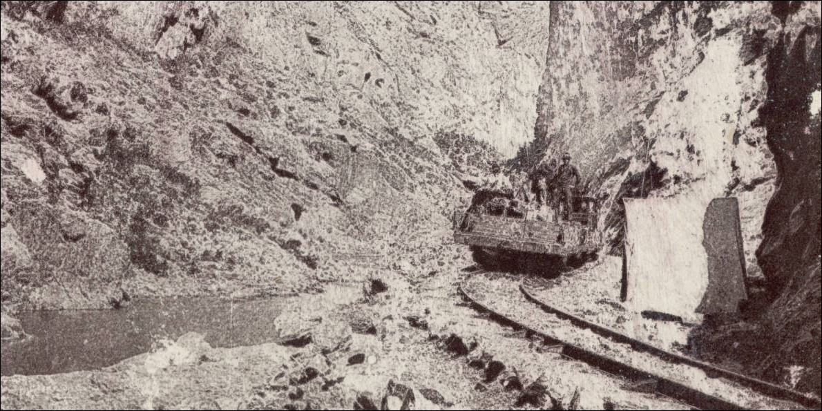
All that being said, I did see one photograph that is entirely new to me, and judging from the composition, I suspect it may be an enlargement from a portion of a larger view.  It is simply described as "DSP&P construction train in the Platte Canyon."  Due to the relatively low quality of the original photograph, or at least its published reproduction, it is difficult to make out many details, but it appears to be an early DSP&P engine pushing a flat loaded with equipment and construction workers, and pulling one or two staked-flats loaded with cross ties or bridge timbers.   Due to the low quality and deep shadows, it is difficult to make out the wheel arrangement of the engine, and the smokestack may either be a Diamond or Nesmith stack (I lean towards the latter), and the location (conjecture only) may be just upstream from the "upper bridge" (a.k.a. Deansbury Bridge) as the tracks approach "Big Boulder."


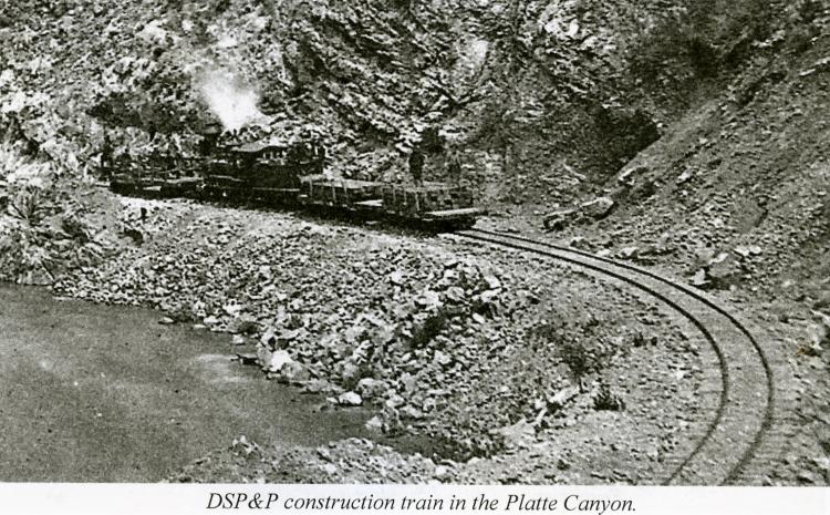
As several random observations, I am not sure that it is actually an original construction train, since the track does not appear to be all that raw (fully ballasted and such), and this may simply be a westbound work train going to repair a washout or to upgrade an existing bridge.

Has anyone seen this photo before, and do you have a better copy?

Does anyone have contact information for author Michael Brown so that I might ask him about this photo?
Craig H. Trout
Reply | Threaded
Open this post in threaded view
|

Re: New Alpine Tunnel Book + Platte Canyon Construction Question...

ComoDepot
Reply | Threaded
Open this post in threaded view
|

Re: New Alpine Tunnel Book + Platte Canyon Construction Question...

Robert McFarland
In reply to this post by chtrout
The Platte Canyon photos are part of the Ted Kiersey collection which can be found in Steve Hatch's DSP&P part of the Railway Engineering website
Reply | Threaded
Open this post in threaded view
|

Re: New Alpine Tunnel Book + Platte Canyon Construction Question...

chtrout
Robert, thank you so much...

Now knowing that the photo was from the"Ted Kierscey collection," I was able to easily find it on another site at:

https://www.narrowgauge.org/ngc/graphics/tkierscey/dspp/dspp003.jpg


Unfortunately, the site does not include the photographer, but only provides the caption "DSP&P Railroad – Near Dome Rock – 1881," and that it is from the "Ted Kierscey collection."

It is very obviously not near "Dome Rock," but instead within the interior of Platte Canyon, although I'm not certain of the exact location.  It clearly appears to be somewhere above the "upper bridge" (aka "Deansbury Bridge").
Craig H. Trout
Reply | Threaded
Open this post in threaded view
|

Re: New Alpine Tunnel Book + Platte Canyon Construction Question...

Chris Walker
In reply to this post by Robert McFarland
fwiw I've seen that construction train picture, but where it was isn't readily apparent to me at this moment.

The picture of #109 at Baileys is in reality taken at Silver Plume.
UpSideDownC
in New Zealand
Reply | Threaded
Open this post in threaded view
|

Re: New Alpine Tunnel Book + Platte Canyon Construction Question...

chtrout
Also, there is a very "remote" possibility this photo is simply misidentified and this is actually within the Royal Gorge.  For this reason, I would love to see a complete image of the original stereoview, plus any photographer's imprint on the reverse.
Craig H. Trout
Reply | Threaded
Open this post in threaded view
|

Re: + Platte Canyon Construction Question...

Chris Walker
Craig,

I feel your disconcert with the image being in the Canyon of the Arkansas not the Platte Canon certainly has worthy merit.

Unfortunately the image is poor, the rockwork, and sharp river bends don't shout out the Royal Gorge to me but then I rode that line on the modern higher speed line.  I haven't been in the lower Platte and only can go on photos of such.

However in your favour, there are a couple of details that reinforce your supposition.

The Flatcars with added low sides, two behind with one out front, and the poor photo quality go hand in hand with this photo actually in the Royal Gorge.  


http://digital.denverlibrary.org/cdm/ref/collection/p15330coll22/id/23201

The way the Crew is decorating the cars lends me to feel this was part of a series of Record perhaps.

Note that distinctive headstock on the Flatcar, there isn't the buffer block above the drawgear unlike any I've seen in DSP&P early photos.  A quick glance at the several published DSP&P construction train photos show the Flatcars all flattopped.

More investigation is needed on this I think  Thank you for raising that.
UpSideDownC
in New Zealand
Reply | Threaded
Open this post in threaded view
|

Re: + Platte Canyon Construction Question...

chtrout
Hi Chris,

Thank you for your very well thought out and nicely detailed response.

First I want to stress that I am not saying for certain the photo is "misidentified," I am just wanting to raise that outside possibility as a potential explanation.

As background, I have both hiked and ridden the entire length of Platte Canyon many times on my bicycle while growing up in nearby Littleton, Colorado, and I feel very familiar with its entire length.  Additionally, I have a very large collection of original stereoviews of Platte Canyon for the 1870s and 1880s, and I just can't seem to match this exact stretch of track in the subject photo with any images in my collection.

I have an even larger collection of original stereoviews for the Royal Gorge, and again, I cannot quite match this exact stretch of track to any that I am familiar with.  

Regardless, I did find your comments on the nature of the equipment very interesting.

I will continue to search for images of the original stereoview, which hopefully will also include images of the photographer's imprint or any text on the reverse.  Also, a full image of the original stereoview would include both the right and left images, and in some cases, one of the images is numbered and titled, which might be useful when looking at a sequence of numbered stereo views.  I am disappointed that the truly remarkable images in the "Ted Kierscey collection" often do not include the name of the photographer, or images of any imprints on the back of the stereoview.  

Going back to the original, it is labeled as being "Near Dome Rock" in 1881, and that simply cannot be correct since the valley at Dome Rock has opened up into more of a broad U-shaped valley, rather than the steep-sided canyon depicted in the scene.  As for as the date being reported as 1881, this would make sense, considering how "settled-in" the track in the grade appears to be.

Research continues...
Craig H. Trout
Reply | Threaded
Open this post in threaded view
|

Re: + Platte Canyon Construction Question...

South Park
  A Nesmith stack would block all visibility down low, behind the stack.  One
can clearly see the hillside there.  This is not a Nesmith stack.
"Duty above all else except Honor"
Reply | Threaded
Open this post in threaded view
|

Re: + Platte Canyon Construction Question...

ComoDepot
In reply to this post by chtrout
1881 I think was when the Iron was replaced with Steel so there would have been a lot of work trains, bit early to need significant tie replacement.
Reply | Threaded
Open this post in threaded view
|

Re: + Platte Canyon Construction Question...

chtrout
Como Depot,

All I see are ties and possible bridge timbers on the trailing flatcar(s), but I cannot tell what is loaded on the flat car being pushed.  If there are any rails, there are relatively few.  While I cannot be sure, I am thinking this is a work train en route to repair a washout or upgrade an existing trestle.  Regardless, I do not think this is a full-blown "steel gang" replacing iron rails with steel rails.
Craig H. Trout
Reply | Threaded
Open this post in threaded view
|

Re: + Platte Canyon Nope: Royal Gorge.

Chris Walker
In reply to this post by Chris Walker
Chris Walker wrote
More investigation is needed on this I think  Thank you for raising that.
Apparently this urgent Carload derailed into the river and only just was recovered.....


to compare with the Ted Keirscey Collection photo.

My Royal Gorge F7 cabride back in 2009 yielded this view.


My apologies for not getting this done sooner; good job you stuck your head in the doorway again, Craig!


UpSideDownC
in New Zealand
Reply | Threaded
Open this post in threaded view
|

Re: + Platte Canyon Construction Question...

Dave Eggleston
In reply to this post by Chris Walker
Sure looks very possibly a Billmeyer & Smalls flatcar with the distinctive springboard coupler arrangement.

I'd hoped it was a St Charles car...
Dave Eggleston
Seattle, WA
Reply | Threaded
Open this post in threaded view
|

Re: + Platte Canyon Nope: Royal Gorge.

chtrout
In reply to this post by Chris Walker
Chris,

Wow, that comparison photo really "closes the deal," especially with the distinctive rock formation above.   The "Keirscey" photo has clearly been misidentified as Platte Canyon when in fact it was in the Royal Gorge.  Ted Keirscey had incorrectly identified several images in his amazing collection, but all is forgiven, they are all truly wonderful photos.

Why do you say that this is a work train to recover a car that had gone into the river?  You may be right, I am just not seeing anything to suggest that.   The flat car being pushed is very hard to make out but appears to be loaded with some workmen and supplies.   The two trailing flat cars appear to be loaded with bridge timbers and crossties.  Conjecture only, but the train is too short for any heavy construction and is more likely simply installing or repairing water boxes/culverts or short timber bridges.   The distinctive roof line on the engine appears to be consistent with Canyon City & San Juan (AT&SF subsidiary) "The Echo."
Craig H. Trout
Reply | Threaded
Open this post in threaded view
|

Re: + Platte Canyon Nope: Royal Gorge.

Chris Walker
chtrout wrote
Chris,
Why do you say that this is a work train to recover a car that had gone into the river?  You may be right, I am just not seeing anything to suggest that.  

Craig,

Sorry I was being metaphorical, in the usual Railroader terms; relating to the mission I set myself and the unacceptable delay in bringing it to light.

I have long been a "then & now" comparison picture aficionado and during my cab-ride whilst I was videoing the track ahead, I saw the rockwork forming up, I couldn't explain the deja vu feeling and my subconsious made me take the still, and on later review of the trip photos, couldn't remember just why I ceased and took the image, until you posted that Kierscey image above.  

Over the years, I had looked at it many times and thought it was the Arkansas most likely.  The pair of faultwall slabsides were the key and also the River beach, skyline, strata and the track S-curves. The Kierscey image also has poor definition of the South canyon wall, which at that location is very prominant.

Then I just had to come across that trip photo again for it to all click into place.


UpSideDownC
in New Zealand