Forks Creek water tank
123
123
|
Rick,
Thanks for the additional details on the tank. I think I understand most of the abbreviations. Is there a valuation map, I believe that is what the maps posted in the Files Section are called, for Forks Creek? Would it show track layout details, building and bridge locations for the area? Is it safe to assume the C&S used the standard number 8 1/2 turnouts there also? It is a most interesting junction to me, simple yet with all the elements to make it a very railroady location worthy of modeling. Best, Todd Ferguson Harrisburg, NC |
|
Hi Todd,
Yes, there’s a valuation map for Forks Creek (I think from the early 20’s), and it should show all the layout details, building and bridge locations, etc. It will not, as far as I’m aware, show the turnout numbers. I don’t know the history behind the #8-1/2 standard. Did it come from the DSP&P, CC, somewhere else, or was it just what NG stubs were commonly made to? The Forks tracks were re-aligned in 1900, which also may or may not have some influence on the turnout #s used. (Even then, though, they may have just reused the frogs from the previous switches, whatever # they might have been.) Cheers, Jeff. |
|
Hey Jeff, If there is a map that would be a nice one to have in the files area too. I didn't know the track was realigned, but looking at photos it seems to have changed. Is that realignment related to the replacing of the wooden bridge with the steel bridge? That would seem to make sense to me. Of course the goal was to make money, so they wanted to get the trains running and then upgrade the infrastructure as needed and funds allowed. The other factor could be dealing with washouts that had to do their share of damage in the canyon too. I am not sure how the standards were selected back in the early days, but I today I believe the turnouts are sized based on the speed the railroad wants to maintain through the turnouts and the frequency of use. Here on the former Southern Railway mainline they took out conventional turnouts where the tracks went from single to double track and replaced them with higher speed equilateral turnouts. This allowed the trains to maintain 60-65 mph regardless of the route through the turnouts. They are currently rebuilding and reinstalling the double track locally to 79mph standards, upgradeable to 90mph in the future. They will be installing several high speed crossovers in my town. A track foreman told me the points alone are either 85 or 100 feet long. I have been told that rule of thumb is maximum speed through a turnout diverging route is two times the frog number, so, number 30 frog would be a 60mph turnout. Most of these high speed turnouts are closed frog, so the frog rail also moves to form a continuous rail through the frog too. I have drawings that show the D&RGW narrow gauge, and therefore the stepchild RGS, used 8 1/2 and 10 frog turnouts. Theses were point turnouts but I imagine the size would be the same for stubs. Space is much less of an issue for the real railroads than it is for us modelers. I have built a number of Sn3 8 1/2 turnouts and I love how the look and operate, but the do have some length. 8 1/2 in On3 would be interesting and I am planning to build a stub based on the C&S standard in On3. It will probably be about 15-18 actual inches long. So, it seems that narrow gauge turnouts were built for 15-20 mph through the diverging route. At least for point turnouts, stub operation may have been slower. This sounds about right as most speeds were low. I think the RGS stayed at 6mph in yards and towns IIRC. Looking forward to seeing your turnout efforts... Best, Todd Ferguson Harrisburg, NC Sent from my Wacked and Cracked iPad III, OUCH!!!
|
|
Hi Todd,
Unfortunately all the ICC Valuation Maps I have are copyrighted by the Colorado Railroad Museum. (And I only have maps of the South Park line as that’s the part of the C&S I model.) I’m not sure if the track realignment and bridge replacement are related or not. I’m sure others here will know, though. Most of the D&RGW split-point switches started out as stubs, and were replaced as they upgraded to heavier rails. Areas where they stayed with 30 or 40 lb rail (such as the siding at Sargent) kept their stub switches to the bitter end. (I model a few bits of the D&RGW too.) Cheers, Jeff. |
|
Jeff,
In spite of what others say, the tracks were not realigned at Forks Creek in 1900. The abutment to the bridge was moved when the wooden bridge was replaced with the iron one. I have seen this theory before and it doesn't hold water. To realign the tracks in the manner proposed, all of the buildings in Forks Creek would have had to have been repositioned and the line never made enough money to absorb that kind of cost. There is also no mention of anything like this in any of the C&S AFE's or the C&S records that still exist. Rick |
|
In reply to this post by Jeff Young
Jeff, I may have to check my copy of Colorado Central book or contact the Museum... There may be some maps in that book. I just don't recall off the top of my head. I don't know much at all about the South Park lines. I'm sure they interesting to understand and model too. I as many people just had easier access to info about the RGS and the D&RGW. Especially while living in the Midwest or East. Best, Todd Ferguson Harrisburg, NC Sent from my Wacked and Cracked iPad III, OUCH!!!
|
|
In reply to this post by Rick Steele
Rick, Thanks for the clarification. What you're saying makes a lot of sense. When was the wooden bridge replaced with the iron bridge, what year? Was it replaced by the Colorado and Southern or predecessor Road? Best, Todd Ferguson Harrisburg, NC Sent from my Wacked and Cracked iPad III, OUCH!!!
|
|
In reply to this post by Rick Steele
Hi Rick,
> In spite of what others say, the tracks were not realigned…. Rats. Caught out again taking stuff at face value. (‘Twasn’t even the internet I can blame this time; I read that in Harry Brunk’s book.) Cheers, Jeff. |
|
This post was updated on .
I got caught out on this once, not in 1900 but previously: see http://c-sng-discussion-forum.254.s1.nabble.com/Proof-that-not-only-the-Eating-House-was-built-on-stilts-at-Forks-Creek-td948.html#a969
the photos show a different alignment to the original there. One thing I can say for certain is we all have missed the Switch upgrade to Blades at Forks at some time! One bladed Turnout on the Clear Creek line to go with the one at Como.
UpSideDownC
in New Zealand |
|
The photos can appear to be a lot of things. The realignment argument really gets good once the stone wall was built behind the depot and eating house and it was backfilled to make it more sturdy and less prone to washouts when Clear Creek got a bit testy. That makes it look like they were moved when, after looking at the early photos of Forks Creek, it is readily apparent that there was no place else to move them to, This is especially true when looking at the width of the canyon and sharing the river with the buildings and the right-of-way.
I am still of the opinion that it was after the wooden bridges were replaced with iron bridges and the attendant rebuilding of the abutments to accommodate these new bridges that the new "configuration" appears. Hol Wagner and I discussed this at length and both agreed that in the absence of any compelling (that means original C&S) evidence to the contrary, we are in agreement that Forks Creek's buildings remained in their original positions throughout the existence of the station. I hate to disagree with Harry,... but even among friends.... Rick |
|
Rick,
So, was this post in the thread about Forks Creek found to not be accurate? John Schapekahm Reply | Threaded | More Feb 12, 2015; 8:37pm Re: Proof that not only the Eating House was built on stilts at Forks Creek. 233 posts In reply to this post by Chris Walker Chris = The Union Pacific Denver and Gulf railway made extensive trackage improvements at Forks Creek. The April 17, 1891, issue of the Idaho Springs Sifting-News reported “on the north side of the station the rock is being blasted away to enable the track to be moved about 6 feet in that direction. The new bed of track will be 3 feet higher than the old one, at a point where it crosses Clear Creek, and the new iron bridge shortly to be erected will be 16 feet longer than the one which was washed away.” The railroad erected a new iron bridge of pin-connected through truss design at Forks Creek during the spring of 1891. The Georgetown Courier on Saturday, June 6, 1891, reported “as soon as the bridge is completed the station and eating house, as also the telegraph office, will be removed below its present location. The company is taking every precaution to guard against having accidents through floods.” B&B crews jacked up and moved the depot structure easterly about 50 feet down the river from its original site to a place about where the former refreshment stand had been. A newly planted conifer tree marked the place the depot formerly occupied. A new platform extended approximately 16 feet between depot and track. The new paint scheme of the day appears to have been ivory with green trim. I will post pictures later showing the change in track layout occasioned by the rock blasting, but right now the dinner bell is just about to start ringing ... Best, Todd Ferguson Harrisburg, NC |
|
Uh……..
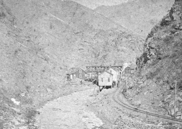 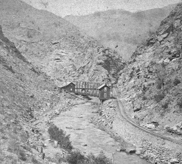 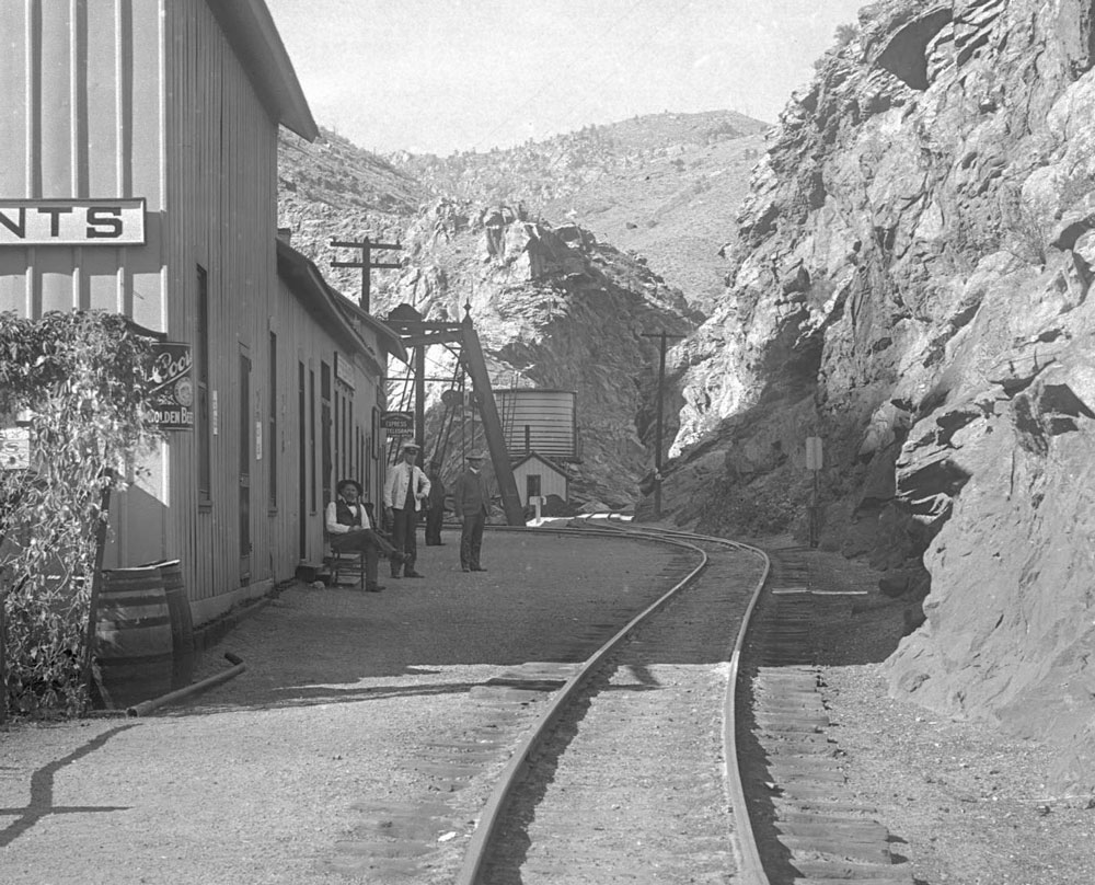
Doug Heitkamp
Centennial, CO |
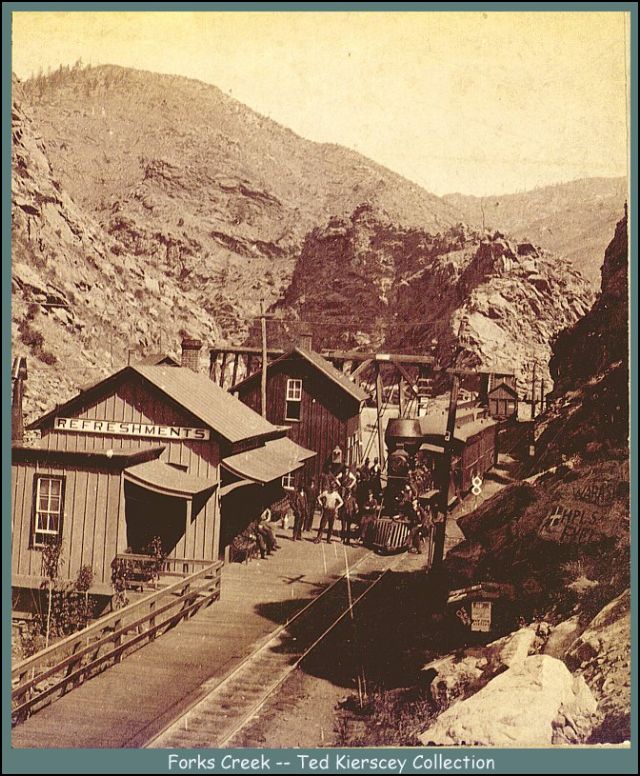 http://www.narrowgauge.org/images/tkcok//m00113.jpg 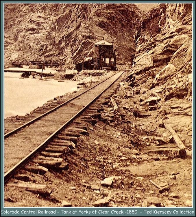 http://www.narrowgauge.org/images/tkcok//m00167.jpg
UpSideDownC
in New Zealand |
|
In reply to this post by Todd A Ferguson
I'm not going there. I told you what we discussed and thought happened. Newspapers are known to be wrong.
Look at the two story building next to the bridge, it still exists on both photos that Doug posted, with another two story appearing at the opposite end of the building strip. As I said, it is highly unlikely. Remember, though, in 1891 the road was still part of the UP system and darned near anything could have happened. The annual report for the year mentions nothing about it (and why would it), but the Pacific Extension is still shown on the route map and it was not renamed to the Baldwin Branch until the following year. So, it's up to you and Jay Gould to decide. Rick |
|
Rick, I understand your thinking and I agree that newspapers and books are not always accurate sources and can produce or perpetuate erroneous information. That is why I was asking about a valuation map as don't those usually document the track including the tangents and curves. I though such a document might help answer the question as to how the track was at least documented at that time. But maybe that info is just not available for Forks Creek. Best, Todd Ferguson Harrisburg, NC Sent from my Wacked and Cracked iPad III, OUCH!!!
|
|
Well, Todd,
If you give me a couple of weeks I can get a map done for you from the Valuations (I have my own copies from the National Archives), but they will be the same as the ICC/CRRM maps. There is a lot of information on them, but since these maps were done for the ICC in 1917-1918, there is not a whole lot of information on them as to what was. It would be great to find the ex UP/UPD&G/C&S engineering map like I have found for Golden and Black Hawk, but if Hysteric Colorado doesn't have them, and the CRRM doesn't have them and CSRM doesn't have them, they we're pretty much stuck with the ICC maps. I saw some erased info on the Trout Creek Pass maps, but the Forks Creek maps don't show much, just the stuff that you saw on the CRRM maps. The field notes show the structures as they existed, not as they were almost two decades prior to the valuation. Rick |
|
In reply to this post by Rick Steele
Pacific Extension?Figuring that this would have been about the time of some abortive grading on the part of the DL&G near Floresta and Irwin and Alpine Tunnel was closed,could the UP seriously have been thinking about building westward to Grand Junction using prior surveys?
|
|
I just know what I read in the annual reports (sorry Will...)
Rick |
|
This post was updated on .
In reply to this post by Rick Steele
Rick,
this 1891 date maybe reinforced by the appearance of the Buda Rotary Switchstands on the Clear Creek lines. EDIT: This view is pre-Dewey Sampler and Newton Concentrator which was first on Sanborn Maps in 1895. In this case the [1891] date by DPL if not accurate is probably close. http://digital.denverlibrary.org/cdm/fullbrowser/collection/p15330coll22/id/3316/rv/singleitem Looking back over the Idaho Springs pictures there is possibly a Buda in a photograph showing the Idaho Custom Mill, which first showed on Sanborn maps in 1890. I say "possibly" as the switchstand visible in this picture is more rotary-like in appearance as previous photographs showed White-painted Harps that really stood out. http://digital.denverlibrary.org/cdm/fullbrowser/collection/p15330coll22/id/3303/rv/singleitem/rec/304 The most conclusive picture showing the Budas throughout I.S. has the Jackson mill also in the picture, that Mill was opened in 1896. http://digital.denverlibrary.org/cdm/fullbrowser/collection/p15330coll22/id/3285/rv/singleitem This leads me to a theory that when researching and writing about such things one is governed by either written records if the author can locate these and the earliest photograph that the author has located. One can sit on one's hands and never bring things to print in the eternal hope of new discoveries.... or go with what is available at the time. I noticed that Harry Brunk in later parts of the NG&SL Gazette "Up Clear Creek" series, often mentioned more new evidence that he had come to light, and was more than willing to present this new material. I haven't reread all those yet, I don't recall Harry being aware of the changeover of switchstands nor using that to date pictures. Has anyone else ?
UpSideDownC
in New Zealand |
|
In reply to this post by Doug Heitkamp
Harry Brunk prepared an article years ago in the Gazette on the Idaho Springs tank. It caught my eye because it had cast iron columns with nice capitals. I forged ahead and built the barrel thinking I would figure out how to model the columns. Well, I never did find a suitable column, and proceeded to make a more standard frame base for the tank, and installed a shingle roof on the thing.
As my SketchUp skills are progressing, the columns recently returned to my mind: 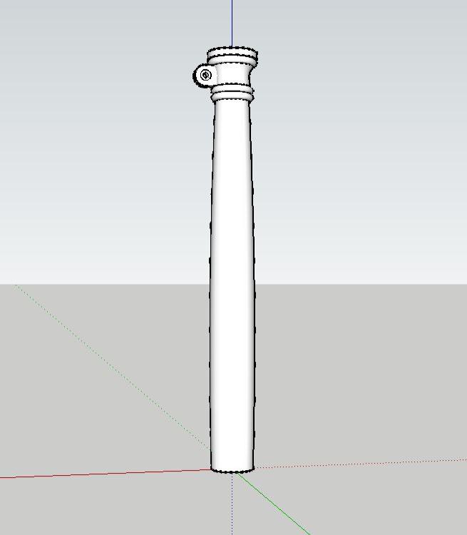 I posted this to Shapeways and will wait a day before placing my order. I don't know that I will replace the roof, but the works will make a favorable stand in. Who wants to recommend a source for the spout? Where did Banta get his casting in the day? Rio Grande Models?
Keith Hayes
Leadville in Sn3 |
«
Return to C&Sng Discussion Forum
|
1 view|%1 views
| Free forum by Nabble | Edit this page |

